You are viewing the expanded version of this Harbour,
for faster browsing
use the regular version here
Dundrum Harbour
Courtesy Flag
Flag, Red EnsignWaypoint
54°13.35N 005° 48.4W This is within D401 but it is impossible to get into Dundrum without infringing this Danger Area.Charts
AC 044-0 Nose of Howth to Ballyquintin point. Imray C62 Irish SeaRules & Regulations
D401 is used for small arms up to Mortar and Anti Tank weapons and the seaward side of it is essentially a safety area for “over throws”. When the range is active they fly Red Flags by day and red lights by night. The presence of these flags does not prohibit passage through the danger area. The authorities can expect that you will not linger in the area and they operate on the “Clear Range” principle. Range control is not contactable either by phone or VHF but, if you need to cross the range and the red flags are being flown, call Belfast Coastguard on #16 and they can contact the RSO.Hazards
Drying and awash rocks, see "Approach and Entry"Tidal Data Times & Range
HW is HW Belfast +0005 MHWS 4.8m MHWN 3.8m MLWN 1.8m MLWS 0.8m The streams into and out of the lagoon and in the anchorage are quite strong but unspecified.This site is designed for slower, roaming broadband connections, like you would get at sea, so it needs JavaScript enabled to expand the text.
General Description
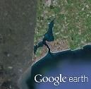
Dundrum harbour lies in a lagoon approached through a narrow channel with a sand bar at the seaward end.
The harbour was a fairly busy port and at one stage they tried to operate a ferry service from here to England but the tidal access limited that developement. Nevertheless it remained active as a port until the 1980’s but the competition from the other harbours on the East Coast finally brought that period of its history to an end.At various stages during the last two centuries there have been ambitious plans by its successive owners to enhance its attraction to the tourist trade; at one stage they had even hoped to build baths and turn it into a spa town for the rehabilitation of invalids et alia but these were never followed through to their conclusion. The result is that the main attraction here is its castle and the total lack of more raucous resort “amenities”!!
It is now a quiet holiday resort and dormitory town away from the hustle and bustle of commercial life. The town quay and the warehouses have been redeveloped as pleasant residential property and a railing fence has been erected around the quay to protect that property. (Can’t have landlubbers falling into the ‘ogwash, can we?)
Approach
Between the entrance to Dundrum channel and St John’s Point, all the way round....
....the bay there is a scattering of rocks, drying, awash and hidden up to a mile off the shore; you need an offing of at least a mile and it is not possible to route in a straight line from the Point to the channel. Note that the last close inshore survey was done in the early sixties and the Navionics chart is just a scan of the UKHO chart of the area. From the southern side the only rock to look out for is the Roaring Rock off Dunmore but is only two and a half cables off the shore so in the normal way of things should not cause a problem. The main hazard here is the depth of the unbuoyed channel into the anchorage; it is recommended that the approach should only be undertaken by shallow draft boats in settled conditions. That’s not to say it is not possible for fin keel boats; it has been done in recent years, at HWS and very, very carefully.
As has been stated above this approach should only be attempted by shallow draft boats in settled conditions on a rising tide. There may or may not be recently laid buoys in the channel but the best bet is to use two clearing transits: the castle ruins bearing 330T and a transit of the West point of the entrance in line with the church spire at the northern end of the village.
Run in on the 330T bearing until about a cable off the East side spit and then edge over to port to pick up the church/shore line transit. Hold this until abeam the old pile structures and then, leaving them about 50m to port, head for the quay and leave an old pole marker (if it is still there) fairly close to port and pick a spot to anchor off the quay.
There is a quay wall at the town which is the left over from when this was a trading port. That can be approached 2 hours either side of HW but it is not a good idea to dry out there because the strong currents there have scoured out a channel next to the wall which is evident from the photo of the quay. Also, note from that photo that local boats are moored fore and aft to the quay wall and there doesn’t appear to be much in the way of ladders.
There are quite a few local moorings with boats on them and probably quite a few more unbuoyed ones without boats so it would be a good idea to deploy a tripping rope with your anchor.
Having issued all the dire warnings if you make your approach at the top end of a rising tide there is very little danger of a mishap. There is an anchorage just to the SW of the Craigalea drying rocks where you can wait for the tide but if the range flags are flying you will be very unpopular with the RSO if you drop anchor too far to the west of those; probably better to wait between Newcastle and Dundrum or in the bay to the NNW of St John’s Point. If conditions are not suitable for anchoring in any of those places then they will not be suitable for an attempt on the entrance to the harbour here.
It’s worth restating the position on the Range here; you, basically, have the right to transit the range for navigational purposes so if you wish to go into Dundrum and they are flying red flags that should not deter you from making an approach. Just don’t hang about unnecessarily in the Range and if you are at all worried call Belfast CG and ask them to tell the Range of your intentions.
Berthing, Mooring & Anchoring
If you need to take on water, fuel of other stores it is possible.....
..... to tie alongside the quay for a couple of hours either side of HW. The harbour is unmanned, so no harbour dues.
Facilities
You will find water on the quay, fuel from the garage on the other side of the housing development on the quay and groceries from one of several stores on the High Street.
Eating, Drinking & Entertainment
There are several pubs and eateries here of good repute and, of course, a fish and chip shop!
Links
|
Got a comment to make about Dundrum Harbour ? Have you found this coverage helpful ? HAVE YOUR SAY (your email address will always be kept private)
Your Ratings & Comments


