

Marina Information (use the  icons to find out more)

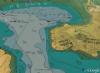

Dunstaffnage & Loch Etive
Your Comments: 6 Read or add your comments
Courtesy Flag
Flag, Red EnsignWaypoint
56° 27.65N 005° 26.73WCharts
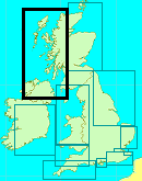
AC 2388 Loch Etive and Approaches, Loch Etive, Dunstaffnage Bay to Connel Bridge; Imray 65 Crinan to Mallaig & Barra (with Dunstaffnage Bay chartlet); SC5611.19 West Coast of Scotland Pack; Approaches to Loch EtiveRules & Regulations
None knownHazards
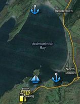
Reef off the end of Rubha Garbh-aird (Northern arm of Ardmucknish Bay). Use the stern bearing on AC 2388 to avoid this.Tidal Data Times & Range
HW Dunstaffnage is the same as HW Oban MHWS 3.9m MHWN 3.0m MLWN 1.9m MLWS 0.8m The ebb continues out of Loch Etive for a couple of hours after LW (links)This site is designed for slower, roaming broadband connections, like you would get at sea, so it needs JavaScript enabled to expand the text.
Approach
Dunstaffnage Bay & Marina. There is a new wave break pontoon and buoyage here ... read more
Berthing, Mooring & Anchoring
Apart from the marina in Dunstaffnage Bay it is possible..... ... read more
Your Ratings & Comments
6 comments
UPDATE JULY 2022
Written by Don Thomson 3 | 29th Jul 2022
I reviewed these notes in July 2022. The main change here is that the management has changed and, of course, the Oban stop over pontoons have been working for several years now which is making a difference here and at Kerrera
Update Early Summer 2021
Written by Don Thomson 3 | 24th Jun 2021
These notes were reviewed in June 2021. Prices have changed but not very much else
Entry to Loch Etive
Written by dashhouse | 10th Apr 2019
Contrary to the advice in the main body, you can get into Etive at around slack high or low water (about an hour either side), but use timings for Bonawe, not Connel. Everything is delayed by the reef just to the east of the bridge. You can find very accurate predictions of conditions and timings here: fallsoflora.info . Antares Charts do a very useful chartlet for navigating under the bridge.
1 of 1 people found this helpful
UPDATE APRIL 2017
Written by Don Thomson | 6th Apr 2017
These notes were reviewed by Don in April 2017. We've already updated here for the new marina layout and we also note that they are holding their mooring fees for this year.
Update December 2016
Written by Don Thomson | 13th Dec 2016
They have laid a new wavebreak pontoon here which has necessitated a change to the buoyage and the near approach to the pontoons. We have uploaded a new image in the Navigation Images and altered the approach instructions accordingly.
Update 2015
Written by dononshytalk | 20th Mar 2015
These notes were reviewed by Don in March 2015. I've added a berthing plan for the marina to our gallery (a little blurred!) and prices are updated
© visitMyHarbour.com | website design created by Black Culm Ltd