You are viewing the expanded version of this Harbour,
for faster browsing
use the regular version here


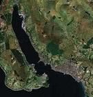
Gareloch and brief notes on Loch Long and Loch Goil
Courtesy Flag
Flag, Red EnsignWaypoint
None GivenCharts
Admiralty, 2000 (Gareloch), 3476 Loch Long, Loch GoilRules & Regulations
Whole raft of rules and regulations, the Lochs described are "Dockyard Ports" & controlled by the Royal Navy...see text and links. 7 knts speed limit in the "restricted" areas. Outside Loch Long and the Gairloch the Clyde is governed by Clydeport (a civilian company) and the only rule you really need to know is that the navigation channels from the Cumbraes inwards are Rule 9 ie everything gives way to ships whose movement is considered restricted by draft.Hazards
Submarines and Navy VesselsTidal Data Times & Range
+0110 Dover, MHWS 3.4m, MHWN 2.9m, MLWN 0.9m, MLWS 0.3m (links)This site is designed for slower, roaming broadband connections, like you would get at sea, so it needs JavaScript enabled to expand the text.
General Description
The area covered starts at the entrance to Loch Long and gives a very brief....
.... description of this loch, and Loch Goil which branches off from it. There are no dedicated facilities for yachtsmen or motorboaters within these two lochs, but there are anchoring possibilities, a few visitors moorings provided by hotels for their customers and 10 visitors buoys at the head of Loch Goil. Village style provisions can be obtained within these lochs.
This article also covers the Gareloch, where there are plenty of facilities for small craft including a Marina, boatyards and yacht clubs.
These three lochs all come under the jurisdiction of the Queen's Harbourmaster of the Clyde Dockyard Ports of Gareloch and Loch Long. Faslane in the Gareloch is the base for Britain's nuclear submarine fleet. Naturally security is tight, and there are a whole raft of rules and regulations including restricted and prohibited areas.
These are all covered fully in the "More Information" section. Anyone planning to visit this area needs to familiarise themselves with the regulations, and also pay close attention to the areas as marked on the Admiralty charts (the latest versions of which are displayed on this site).
In actual practice unless there is movement of these submarines or attending vessels, small craft should have no trouble navigating the area. Even when there are movements and restricted areas apply, there is often enough room to wiggle past without impinging. Perhaps the main exception to this would be the Rhu Narrows in the Gareloch, where it would not be wise to try and negotiate the passage at the same time as a submarine or ship movement. (Check the photo gallery).
Check the text from the Admiralty Pilot in the "More Information" section on this page, and use the link below for more information:
Approach
This section describes approach and entry to Loch Long, Loch Goil and the Gareloch....
.... together with a brief rundown of anchorages, moorings and facilities in the first two. Berthing facilities in Gareloch are covered in the next section. Although navigation in these waters would appear to be simple, if you have ever traversed this area on a dreich day you will know that it can be difficult to make out the entrances to the various lochs. As you pass the Cumbraes into God's own country you can be faced by a wall of greyish green mountainous shoreline which gives an ampitheatre effect with no apparent breaks. You would be advised to put waypoints into your GPS or keep a good plot going until you are certain that what you think is the entrance to your particular destination loch is, in fact, correct. More than a few large ships bound for Glasogow have found themselves going up Loch Long having missed the Tail o' the Bank completely. Another favourite mistake is to identify Loch Long as the Holy Loch (which can be missed altogether) and then pushed up into the Gareloch when aiming for Loch Long. So, be warned, do not drop the nav and rely on the Mark I eyeball until you are certain it hasn't been fooled.
Loch Long
Approach and entry to Loch Long is simple enough, with the red and white Loch Long safe water mark (Oc) laying centrally in the middle of the entrance. The East side of the entrance off Barons Point is marked by the green conical buoy Kil No3 (Fl.G.5s).
Cove Bay and the eastern shore about 500m north of Barons Point could provide a possible anchorage. There are plenty of private small craft moorings, and 6* 15 tonne well maintained moorings with pickup buoys, for the exclusive use of visitors to the Knockderry House Hotel. The Hotel encourages the well heeled, (their cheapest bottle of wine was £19) sailing fraternity.... telephone 01436 842283, and a link to their website is provided:
http://www.knockderryhouse.co.uk
Further into Loch Long on the Western side, Finart Bay (not to be confused with Finnart, much further in on the East side), can also offer anchoring possibilities. Close attention to the charts will be required as there are large drying areas, and the loch shelves steeply.
We have been told that the Ardentinny Hotel (Tel 01369 810126) is under new management and is now (2018) refurbished. In May of 2018 they have started to lay visitors buoys intending for there to be six of them. Update - there are now 6 Buoys, Free as long as you go ashore and spend some money there!!
Pushing further into Loch Long will bring you past the Coulport Jetty, c/w chimney and towers, or your starboard side. This is followed by a covered floating dock. This whole area is protected and restricted, see the notes in the "more info" section. Basically you are not allowed to go within 150 m of any of these installations, and there are guard boats to make sure you don't. At certain times access to the whole area is restricted altogether, leaving a very narrow passage alongside the western shore .. see the regulations.
Pushing further into Loch Long the entrance to the Loch Goil will be seen on your port hand side, and about a mile further on the Finnart Ocean Terminal comes up on your starboard side. Large tankers have to manoeuvre in the restricted space of the loch, beware.
Moving further north-east, Glenmallan Jetty also has a prohibited area... keep at least 150 m away from this installation.
In general this Loch is as it's name suggests, long and narrow... being surrounded by mountains violent squalls of wind can be expected.
The other anchoring possibilities can best be seen by reference to the chart provided, as can the extent of the restricted and prohibited areas.
Latest The new pontoon has been installed at Arrochar and there are new images in the Gallery. You can find further information HERE
Loch Goil
Again, entry to Loch Goil is simple enough, it branches off Loch Long on the Western side between Rubha nan Eoin on the South side and Carraig nan Rocks (Dog Rocks) on the northern side. The latter is marked by a beacon (Fl.2s7m11M). Entering centrally and proceeding Northwest will take you past the red can No1 buoy (Fl.R.3s) on your port side, followed by passing between the red can No2 buoy (Q.R) and the green conical No3 buoy (Q.G). There is also a sector light shining out of the entrance; it is very bright and can be seen clearly in daylight.
Inshore dangers in this area are clearly shown on the large scale chart provided, and include an unlit heavy mooring buoy.
Sometimes Loch Goil is used for submarine and other trials, and is closed for this reason. Keep clear of any rafts, buoys, and Douglas Pier (on the Western side a mile from the head of the loch). If you are visiting Loch Goil for the first time it is essential that you visit the two sites below (will open in a separate tab)
http://www.legislation.gov.uk/uksi/2011/1680/made
http://www.carrick-castle-boat-club.co.uk/speed-limits.html
As you proceed inwards in a north-north-westerly direction on your port hand side you will see Carrick Castle (photo gallery). Around this area there are anchoring possibilities in reasonably shallow water. If you see a large red board displayed at Carrick Castle pier (repeated at Douglas Pier) it means that the trials area is in use and you should contact GXA on #69 to inform them of your intentions.
Carrick Castle Boat Club's has 3 blue visitor's moorings one cable north of the castle - Visitor's Mooring No 1 in approximate position 56 deg 06.688' N 004 deg 54.378' W and Visitor's Mooring No 2 in approximate position 56 deg
06.710 N 004 deg 54.396' W. The blue buoys with yellow pick up buoys will accommodate any yacht or motor boat up to a maximum of 15 tonnes and are always serviced annually each spring. There is a £10 charge for using one of these. Details on the website below:
Further to the north of Carrick Castle is The Perch, a submerged reef marked by a beacon... this is a metal structure with an orange rectangular topmark. It does not mark the eastern edge of this reef, but is mounted on the shallowest part. Leave it well to port if heading northwards.
On the shore to the north-west of The Perch Beacon is a similar beacon, and they on line up on 318 degrees T to aid entry to Loch Goil. There is also a directional light on the perch Beacon, (Dir F.WRG.3m5M), the narrow white sector of which helps lead you in at night. All this is best seen by reference to the large scale chart provided, as are other anchoring possibilities within Loch Goil, as far as the Village facilities at Lochgoilhead.
There are 10 visitors buoys at Lochgoilhead; they are near the jetty on the chart, clearly marked and, as the shore is steep to here, they are pleasingly close to the jetty with its pontoon.
Update June 2022 The old pontoon has been replaced by a very swep up affair under the care of the Lochgoilhead Jetty Trust - latest image in the Gallery from earlier in 2022.
Fees for using these buoys can be paid at the honesty box or the small workshop/garage to the right as you come ashore. In the village there is a reasonably stocked shop/post office and a hotel/restaurant/bar
Keep well clear of MOD barges that may be connected to adjacent yellow buoys by cables.
The Gareloch
The Gareloch is entered between Rosneath Point to the West and Helensburgh to the east. It is around the point the River Clyde and the Firth of Clyde meet.
If approaching up the Firth of Clyde, a swing to starboard would have been made in the region of the entrance to Loch Long, and the Rosneath Patch, marked by an isolated danger mark (Fl (2)), would have been left on your starboard hand side.
Keep a good lookout for large or naval vessels in the Ardmore Channel, there is enough room for small craft to keep right out of this channel altogether.
Perch Rock laying to the north-east of Rosneath Point needs to be given a good offing, and this can best be achieved by leaving the red can No24 buoy (Fl.R.5s), on your port hand side before swinging North into the Gareloch.
For small craft it probably makes sense to nip straight across the deepwater channel leading out of Gareloch, and make towards Helensburgh Pier on the north-east side of the entrance. Once in reasonably shallow water (and outside the main channel), a turn can be made to the North West. Be aware that this is a seaplane operating area....Col Regs Rule 18e reproduced below...
"* (e) A seaplane on the water shall, in general, keep well clear of all vessels and avoid impeding their navigation. In circumstances, however, where risk of collision exists, she shall comply with the Rules of this Part."
The Gareloch entrance channel can be paralleled by small craft, leaving the green conical buoys close to port, and being careful not to drift too far to starboard, especially in the region of Ardencaple Castle.
Take note of the restricted areas, shown on the large-scale chart provided, that are only activated during submarine movements. Full details, including the signals to look out for are given in the "more information" section. In the normal course of events if a submarine is not moving, it is permissible to use the main channel.
More information about berthing and anchoring in the Gareloch are given in the next section...
Berthing, Mooring & Anchoring
This section only deals with the Gareloch....
..... the anchorages and facilities in Loch Long and Loch Goil have been briefly covered in the "Approach and Entry" section.
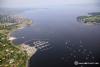
Once past Cairndhu Point to the North, and Castle Point to the South, Rhu Marina will clearly be seen. The breakwaters protecting it are very low slung indeed. The small green conical buoy (Fl.G.4s) to the South of the Marina entrance needs to be left on your starboard side. Don't try and pass between this buoy and the Marina breakwater, as you will foul the end of a sunken rock causeway...

Entrance to the Marina should be made when the entrance bears North or Northeast. The edges of the low-slung breakwaters are marked with red and green pyramid beacons These are lit at night, (fl 4 sec) however due to local regulations the lights are not bright and they are low.
Visitors tend to be berthed alongside the first pontoon you come to, just on your port side as you enter. Vessels up to 60 feet long can be accommodated at all states of the tide.
Telephone the Marina on 01436 820238, or call on VHF channel 80, Rhu Marina. A link to their website is provided below:
This Marina also operates swinging moorings rented on a long-term basis.
Visitors mooring rates here work out in £3.25per metre per night, and a flat rate of £15.00 for short stays under five hours. If looking for a jump off point for the Forth & Clyde Canal, consider James Watt Dock (much cheaper)
Most possible anchoring spots around the Marina are taken up with moorings, however Rosneath Bay on the southern side could be used with caution, although drying rocks radiate from the shore. Once again there are many small craft moorings in this area.
If intending to pass West through the Rhu Narrows, don't underestimate the extent of the drying spit off Rhu Point, on the north-east side. It is marked by a beacon WGW (Fl.3s 6m 6M). Also it would probably be unwise to attempt this when the restrictions regarding moving submarines are in force, even though enough potential room is shown in shallower water on the SW side of the narrows.
Once through the narrow gap on the north-east side will be seen moorings belonging to the Royal Northern and Clyde Yacht Club. They maintain some moorings for visitors, complete with a launch service for £15 overnight. A link to their website is provided below for more information and their telephone number is 01436 820322. They have a clubhouse with showers etc and a bar/restaurant with specified opening hours.
On the south side of Stroul Bay, just as you come through the narrows on your port hand side, will be found the moorings of Silvers Marine. Full boatyard facilities and repairs are available here, and they may be able to help out with a mooring. They have water and fuel available ashore. Try calling them on 01436 831222, a link to their website is provided below:
http://www.silversmarine.co.uk
Other small craft moorings extend up either side of the loch, close into the shore where the water is shallow enough.
A glance at the chart will show that further into the loch, the Faslane submarine base has a protected and prohibited area all round it, furthermore a restricted area and a submarine operating area.
There is enough room to slip up the Western side of the loch without getting in their way, and make it up to Gairlochead, where you will find most of the room suitable for anchoring taken up with more small craft moorings... village supplies are available here.
Facilities
This section only deals with the facilities at Rhu Marina, other facilities in this somewhat spreadout area have already been briefly touched on.
Water and electricity (included in the mooring fee) are available on the pontoons, showers and toilets ashore. The fuel berth here sells diesel, those needing petrol will need to take jerry cans to Helensburgh (about 2 miles)
Both Calor gas and camping gas are available here, while the on-site chandlery could come in useful. Other on-site services include marine electronics, marine engineering, boat building, RYA training, etc.
Boats of up to 35 tonnes can be lifted four hours either side of high water with shoreside storage. In addition there is a 4 tonne shuttle lift for smaller craft and a mobile crane for stepping masts etc.
Provisioning can be acomplished at Helensburgh, where a good supply of shops, banks and supermarkets etc. Will be found.
Transportwise for crew changes the town is served by three railway stations, Helensburgh Upper on the West Highland Line, Craigendoran, on the North Clyde Line and Helensburgh Central, the terminus of the North Clyde Line.
More general local facilities include various slipways suitable for trailer sailers..
The Pier Slipway at Helenburgh gives access to all the tidal range and is in the centre of the town by the pier. It can be extremely slippery, although it is capable of taking a larger boats (6m). It has been recommended to use a long rope for recovering the boat and trailer.
There is another free slipway at Rhu, not to be confused with the Outdoor Centre who have their own private ramp. This is only offers access at around a quarter of the tidal range, and may be suitable for smaller boats only.
On the other side the caravan site at Castle Point has a slipway for which there are charges. This gives access at all the tidal range and there are some facilities and parking included.
More Info
Extracted from Admiralty Sailing Directions West Coast of Scotland 2004 edition
Orders in Council, issued in 1967 and amended in 1971, 1972, 1973 and 1983, supplemented by Bylaws which in 1971, 1973, 1986 and 1992, enacted certain rules and regulations to be observed within the limits of the Clyde Dockyard Ports of Gareloch and Loch Long.
The limits of these Dockyard Ports, together with the limits of a restricted channel, restricted and protected areas, and prohibited areas within them, are shown on the charts of the area concerned.
Following is a summary of these rules and regulations enacted by the above Council and Bylaws which are in force (2001).
REGULATIONS
PRIVATE MOORINGS
1. No person shall lay moorings for private vessels, hulks, rafts, pontoons, bathing stages or any floating structures in Rhu Narrows Restricted Channel or in the Faslane or Coulport Protected or Restricted Areas, except with the licence in writing of the Queens Harbour Master. All such moorings shall be laid in a position designated by the Queens Harbour Master with the consent of Clyde Port Operations Limited, and shall be removed forthwith on the order of the Queens Harbour Master.
CLEARING ANCHORS AND MOORINGS
2. If at any time the anchor of any merchant or other private vessel hooks any crown moorings, or any electric cable, or moorings of buoys or any pipe, the master of such vessel shall forthwith give notice thereof to the Queens Harbour Master, and shall if safe and practicable, await his instructions or those of Clydeport Operations Limited before proceeding to clear the same.
FISHING IN FASLANE DOCKYARD PORT
3. Any person fishing in the Dockyard Ports shall comply with any directions which may be given to him by the Queen's Harbour Master. No fishing from boats or fishing by persons swimming under the water shall be carried on within 150m from the walls, slipways, roadways or boundaries of Her Majesties Naval Establishments, or from any naval moorings, floating docks, or dolphins, save with the licence in writing of the Queen's Harbour Master and in accordance with any conditions attached thereto.
Save with the permission in writing of the Queens Harbour Master and in accordance with any conditions attached thereto, no trawling or fishing by nets, whether drift or set nets, or the laying of lobster and/or crab pots, shall be carried on
(a) In Rhu Narrows restricted Channel or in the Faslane or Coulport Protected or Restricted Areas; or
(b) within the degaussing ranges, so far as they fall within the limits of the Dockyard Port, their positions being shown on current Admiralty Charts; or
(c) in any part of the Dockyard Port where it would obstruct any vessel exhibiting the International Code Flag " Second Substitute" at the yardarm or any submarine when making degaussing range runs over the ranges in (b) above.
SWIMMING AND DIVING
4. No person shall swim or dive within 150m of the walls, slipways, roadways or boundaries of any of Her Majesty's naval establishments, or from any naval moorings, floating docks, dolphins or ships of Her Majesty, save with the licence in writing of the Queen's Harbour Master and in accordance with any conditions attached thereto.
SHIPKEEPERS
5. If in an emergency it is necessary for any merchant or other private vessel, barge, hulk, raft, pontoon or other floating structure temporarily to lie anchored or secured to moorings in a Protected or Restricted Area, or in or near a main channel anywhere within the Dockyard Port, the master or owner thereof shall not leave such vessel or structure without a shipkeeper on board.
USE OF WHISTLES
6. A whistle shall not be used within the limits of the Dockyard Port except:
(a) As a signal of distress: or
(b) To prevent collisions; or
(c) In fog, mist, falling snow, heavy rainstorms or any other condition similarly affecting visibility; or
(d) In accordance with the Rules contained in this Order and for the control of tugs: or
(e) To test the whistle.
USE OF GUNS
7. No gun on board any merchant or other private vessel lying in or passing through the Dockyard Port shall be kept loaded, nor shall any gun be discharged from any such vessel over the waters of the said Port except:
(a) As a signal of distress: or
(b) As a signal in connection with the conduct of sailing races.
ANCHORING AND MOORING
8. No merchant or other private vessel shall anchor or fish:
(a) on the line of any electric cable or pipe laid down in the Dockyard Port when such line is indicated by posts or other discernible marks on shore; or
(b) Within any area shown on the Admiralty Charts as an area in which anchorage is prohibited and in respect of which a warning has been conveyed to mariners by notice issued by the Ministry of Defence.
9. No merchant or other private vessel, or barge, hulk, raft, pontoon or other floating structure shall:
(a) make fast to, or lie at, any of the buoys or beacons placed by the Queens Harbour Master to mark channels or shoals in the Dockyard Port; or
(b) be moored or fastened to any of her Majesty's naval moorings, buoys, breakwaters, boom defences, dolphins, jetties, piles or vessels in the Dockyard Port, save with the licence in writing of the Queens Harbour Master and in accordance with any conditions attached thereto; or
(c) be moored or anchored within 150 of any of Her Majesty's naval moorings, jetties, floating docks, dolphins, vessels, hulks, installations or armament depots, save with the licence in writing of the Queens Harbour Master and in accordance with any conditions attached thereto; or
(d) Be moored, anchored or placed in the Dockyard Port so as to give a foul berth to any vessel already at anchor or at moorings, or to obstruct passage within or entrance into any part of the Dockyard Port.
RULES
GENERAL
1. The Queens Harbour Master may, as necessary, require the owner or agent of any vessel of and above 80 tons net registered to notify him of the times of prospective arrivals and departures of such vessels within the Dockyard Port over a specific period including any unforeseen changes of those times.
2. This rule shall apply when it is necessary to carry out the movement of a Fleet Ballistic Missile Submarine or a Nuclear Powered Fleet Submarine to or from a naval establishment within the Dockyard Port.
The owner, agent or Master of any vessel shall comply with any special directions of the Queens Harbour Master at to any variation of the time of arriving or sailing or as to the navigation of the vessel; within the Dockyard Port.
TEMPORARY RESTRICTIONS DURING THE MOVEMENS OF HER MAJESTY'S SHIPS
3. When it is necessary for a Fleet Ballistic Missile Submarine, a nuclear-powered Fleet Submarine, or other large naval vessel to proceed to or from a Dockyard Port, or to be turned, moved, berthed or docked within the area of a Dockyard Port, the Queens Harbour Master may, for the sake of safety of navigation, hoist the following signals. During the period these signals are displayed, no vessel shall enter the waters of the Restricted Area concerned and any vessel within the said area whether under way or at anchor, shall leave the area forthwith. The Restricted Areas and fixed positions at which signals are displayed are indicated on the charts.
FASLANE RESTRICTED AREA
Three green lights vertically disposed, supplemented by day by Code Pendant Nine, displayed at:
(a) Faslane - on the Floating Dock or otherwise in a conspicuous position; and
(b) By tugs or patrol craft in the vicinity of Faslane Restricted Area.
COULPORT RESTRICTED AREA
Three green lights vertically disposed, supplemented by day by International Code Pendant superior to Pendant Nine, displayed at:
(a) Coulport Jetty: and
(b) By tugs or patrol craft at the northern and southern limits of the Coulport Restricted Area.
RHU NARROWS RESTRICTED CHANNEL
4. The restricted channel and the fixed positions at which signals are displayed are indicated on the charts. The signals which bring the Bylaws into operation are a red light above two green lights vertically disposed, supplemented by red rectangular flag with a white diagonal bar, displayed at:
(a) Faslane in a conspicuous position, (normally the QHM building at the southern end of the naval establishment);
(b) Rhu Hard;
(c) The DG Range building adjacent to Green Isle;
(d) The Navy Buildings, Greenock; and
(e) By tugs and patrol craft in the Rhu Narrows, attending the vessel for which the Restricted Channel is closed.
PROHIBITED ACTIVITIES
5. During the period these signals are displayed no person shall:
(a) Enter or pass through or over or remain in or over the Restricted Channel without authority or permission;
(b) Cause or permit any vessel or thing to enter into or upon or to pass through or over or to be or remain in or upon or over the Restricted Channel without authority or permission.
(c) Remain in the Restricted Channel after having been requested to leave;
(d) Make any false statement, either orally or in writing, or employ any other form of misrepresentation, in order to obtain entry to any part of the Restricted Channel;
(e) Intentionally obstruct any person acting in the proper exercise or execution of his duty within the Restricted Channel;
(f) Board, climb upon or remain on board any vessel or thing within the Restricted Channel without authority or permission;
(g) Interfere with, or interfere with the movement or passage of, any vessel or thing in the Restricted Channel.
TEMPORARY RESTRICTION OFF GLEN MALLAN JETTY
6. The Queen's Harbour Master may direct that International Code Pendant Nine be exhibited by day or three green lights disposed vertically by night in a conspicuous position at Glenn Mallan, as shown on the chart, to indicate that an ammunition ship is to be berthed or otherwise moved to or from the jetty. Whilst said signal is displayed all vessels shall, whilst observing the prohibited area below, give a wide berth to the ship being berthed or moved.
PROHIBITED AREA
7. Every vessel, whilst under way in Loch Long, shall at all times keep clear of the area in the vicinity of the jetty at Glen Mallan, as indicated on the chart.
PROTECTED AREAS
8. Protected Areas at Faslane and at Coulport are indicated on the charts.
OFFENCES
9. In respect of the Protected Areas no person shall:
(a) Enter or leave the Protected Areas by land except by way of an authorised entrance or exit.
(b) Enter, or pass through or over or remain in or over either of the Protected Areas without authority or permission.
(c) Cause or permit any vessel, vehicle, animal, aircraft or thing to enter into or upon or to pass through or over or to be or remain in or upon or over either of the Protected Areas without authority or permission.
(d) Remain in either of the Protected Areas after having been requested to leave.
(e) Make any false statement, either orally or in writing, or employ any other form of misrepresentation, in order to obtain entry to any part of either the Protected Area or to any building or premises within the Protected Areas.
(f) Intentionally obstruct any person acting in the proper exercise or execution of his duty within either of the Protected Areas.
(g) fail to comply with any notice prohibiting or restricting access to any part of either of the Protected Areas or to any part (or part of any) building or premises, jetty, berth, pontoon, floating dock, or other installation or structure (including any floating structure) within either of the Protected Areas.
(h) Board, climb upon or remain on board any service vessel within either of the Protected Areas without authority or permission.
(i) Interfere with, or interfere with the movement or passage of any service vessel in either of the Protected Areas.
(j) Distribute or display any handbill, leaflet, sign, advertisement, circular, poster, bill or notice within the Protected Areas, or affix the same to either side of the perimeter fence without authority or permission.
SPEED OF VESSELS NAVIGATING THE DOCKYARD PORT
10. Within the limits of Rhu Narrows Restricted Channel, the Protected Areas and the Restricted Areas mentioned above, the speed of any vessel shall not exceed 7 knots through the water, or if, to ensure safety of navigation, it is necessary to exceed 7 knots, shall be no greater than the speed necessary for this purpose.
No vessel navigating the waters of a Dockyard Port, other than the channel and areas mentioned above shall exceed 12 knots through the water.
VESSELS TURNING ROUND
11. When a power driven vessel under way (including a tug while towing) is about to turn around by day or by night, she shall signify her intentions by four short blasts on the whistle in rapid succession, followed after a short interval, if turning with her head to starboard, by one short blast, and if with her head to port by two short blasts, and whilst turning shall repeat such signal to any approaching vessel. These signals are only to be used by vessels in sight of one another.
NARROW CHANNELS
12. For the purposes of interpreting Rule 9 of the "International Regulations for Preventing Collisions at Sea (19720 (Narrow Channels), the whole of the Dockyard Port shall be determined to be a "narrow channel".
LIGHTS, SHAPES AND SIGNALES FOR DREDGERS
13. A dredger when at work or in position for working shall carry the following lights and signals, viz.:-
Lights between sunset and sunrise
(a) Forward - In the forward part of the dredger at a height of not less than 6.1 metres and not more than 12.2 metres above the hull, a white light in a lantern so constructed as to show a clear, uniform and unbroken light visible all round the horizon at a distance of at least one mile.
(b) Amidships - Three white lights of the said description placed in a triangular form at least 2.4 metres apart, at right angles to the keel with the apex uppermost, the base of triangle to be at least 3.0 metres higher than the forward light and to be also higher than and clear of the framework funnels, or other erections upon the dredger. If a dredger is so moored or working as to make it necessary to prohibit the passage of vessels on one or both sides, a red light (visible as aforesaid) shall be substituted for the white light at the base of the triangle on the side, or sides, on which passage is prohibited.
(c) Aft - One white light of the said description at or near the stern of the dredger and at such a height that it shall not be less than 4.6 metres lower than the forward light.
SIGNALS BETWEEN SUNRISE AND SUNSET
Amidships - Three black balls of not less than 0.6 metres in diameter placed in a triangular form at least 2.4 metres apart, at right angles to the keel with the apex uppermost, the base of triangle to be higher than and clear of the framework, funnels, or any other erection upon the dredger. If so moored or working are to make it necessary to prohibit passage on one or both sides, a red flag or flags at least 1.5 metres in the hoist is to be substituted for the lower ball at the base of the triangle on the side or sides on which passage is prohibited.
SIGNAL IN FOG
In fog, mist, falling snow, or heavy rain storms or in any other condition similarly restricting visibility, a dredger art work or in a position for working shall at intervals of not more than 1 minute sound a gong rapidly for about 5 seconds.
WRECKS AND SUBMERGED OBJECTS
14. Should a vessel sink, be stranded or become a wreck in any part of the Dockyard Port so that an obstruction is caused, or is likely to be caused, the master or owner of such vessel shall immediately notify the Queens Harbour Master.
PORT REGULATIONS, RULES AND GUIDANCE TO MARINERS
Submitted for the Clydeport Guide to Leisure Boating
March 2006
"Mariners should be aware that warships at anchor maintain an anchor watch to cover both navigational safety and security. As a rule, small craft should not approach within 1 ship's length and make every effort to make their intentions clear. They should also be prepared to obey any instructions given from the upper deck or accompanying police vessel - increasing the stand off distance as necessary. Further advice may be obtained from the Duty Controller at Faslane Naval Base (01436 674321 ext 3206 - or as promulgated at www.rnopsscotland.com)".
History
Gareloch
The Gare Loch or Gareloch is a sea loch in Argyll and Bute, Scotland.
A sea loch aligned north-south, Gare Loch is 10 kilometres long with an average width of 1.5 kilometres. At its southern end it opens into the Firth of Clyde through the Rhu narrows. The village of Rosneath lies on the western shore just north of Rosneath Point and gives the name Rosneath Peninsula to the whole body of land separating the Gare Loch from Loch Long to the west. The area lies in the Lieutenancy area and former county of Dunbartonshire.
The town of Helensburgh lies on the eastern shore, giving attractive views across to Rosneath Point. Rhu, to the north of Helensburgh, features a yacht marina. Further north the eastern shore is dominated by the Faslane Naval Base, the home of the United Kingdom's Trident nuclear submarines. The loch was the site of a major naval base during World War II and was used to store decommissioned naval vessels in the 1950s. A shipbreakers yard ceased trading in the 1980s and has been absorbed into the naval base.
At the north end of the loch the substantial village of Garelochhead includes adventure holiday facilities and has a station on the West Highland Line. Garelochhead is used as a Royal Marine training centre. The Gare Loch offers good conditions for sightseeing, sailing and sea angling. The Greek sugar boat Captayannis was heading for the sheltered waters of the Loch but now lies wrecked in the Clyde.
Loch Goil
Loch Goil is a small sea loch in Scotland. It is an arm of Loch Long. The village of Lochgoilhead stands at its head.
Located in the Loch Lomond & Trossachs National Park, Lochgoilhead sits at the head of Loch Goil, a fjord type sea loch. Only 1 hour from the Erskine Bridge, Glasgow Airport the M8 and Glasgow. The village is accessed from the Rest & Be Thankful pass via a 6 mile single track road. This is a special place, surrounded by hills and mountains, with superb loch views, as well as a wide range of accommodation, leisure activities and entertainment. The landscape at Loch Goil shows its remoteness and Highland grandeur with the Arrochar Alps surrounding with conifers in the Highlands of Scotland.
It is used for exercises by Trident submarines from HMNB Clyde at Faslane.
Loch Long
Loch Long is a body of water in Argyll and Bute, Scotland. The sea loch extends from the Firth of Clyde at its southwestern end. It measures approximately 20 miles in length, with a width of between one and two miles. The loch also has an arm, Loch Goil, on its western side.
Loch Long was historically the boundary of Argyll and Dunbartonshire. However in 1996 boundary redrawing meant that it moved wholly within the council area of Argyll and Bute.
The loch was used as a testing ground for torpedoes during World War II and contains numerous wrecks. It is now a popular area for sport diving. The Ardentinny Outdoor Education Centre (on the other bank) also uses the loch for watersports.
The Finnart Oil Terminal is located on the eastern shore of the loch, linked to the Grangemouth Refinery via a sixty mile long pipeline. The eastern shore is also the location of the Royal Navy's Coulport Armament depot, part of HMNB Clyde, and the Glen Mallan jetty, linked to Glen Douglas defence munitions depot.
Important villages on the loch include Arrochar at its head and Cove on the east shore near its foot.
The loch forms the entire western coastline of the Rosneath Peninsula.
The text on this HISTORY page is covered by the following licence
http://en.wikipedia.org/wiki/Wikipedia:Text_of_the_GNU_Free_Documentation_License
Eating, Drinking & Entertainment
If based at Rhu Marina, the good-sized town of Helensburgh is not far. Here the hungry and thirsty crew will find a plethora pubs and restaurants of all kinds. The town is apparently the second most expensive in Scotland for house prices, no doubt driven by the proximity of Glasgow, and accommodating MOD staff based at Faslane, just 6 miles away.
The net result is there is a very good selection, check out the links below:
Pubs:
http://www.pubutopia.com/pubs/H/Helensburgh/
Restaurants:
Restaurants & Places to Eat in Helensburgh 2021 - Tripadvisor
Closer to the Marina will be found the local inn at Rhu Village.
Links
|

Your Ratings & Comments
The toilet and shower facilities have been greatly improved this year (2011) and a small café, open 7 days/week, can provide you with a hot meal.
See www.carrick-castle-boat-club.co.uk for information on the visitor's moorings and there is plenty of local information there too."