

Harbour Information (use the  icons to find out more)

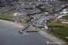
Kilkeel Harbour
Your Comments: 7 Read or add your comments
Courtesy Flag
Flag, Red EnsignWaypoint
None GivenCharts
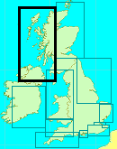
AC 0044 Nose of Howth to Ballyquintin Point, AC 2800-2 Carlingford Lough, AC 2800-3 Kilkeel Harbour, Imray C62 Irish SeaRules & Regulations
None KnownHazards
Off lying rocks at Ballymartin Point, Cranfield Point and Lee Stone Point. Shoals SSW of Kilkeel Point to East of the approach bearing.Tidal Data Times & Range
HW is Belfast +0035. MHWS 4.7m MHWN 4.1m MLWN 1.5m MLWS 0.8m: It is worth noting that although the local fishermen go by the Liverpool Tide Tables (claiming that they are the same as their own) it appears that those tables have more in common with Belfast than Kilkeel. (links)This site is designed for slower, roaming broadband connections, like you would get at sea, so it needs JavaScript enabled to expand the text.
General Description
Contacts: Kilkeel HM VHF #12 tel 028 4176 2287 mobile 07592 786138 ... read more
Approach
In clement weather the entrance to this harbour presents no difficulties. ... read more
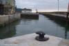
Berthing, Mooring & Anchoring
We have discussed the options for berthing above but re-emphasise.... ... read more
Your Ratings & Comments
7 comments
UPDATE AUGUST 2022
Written by Don Thomson 3 | 3rd Aug 2022
I reviewed these notes in August 2022. This is still mainly a commercial harbour and they were keen to point this out. I was quoted a price of £40 a night for a 10metre boat but the person quoting it was somewhat unshore of his ground.
Update Early Summer 2021
Written by Don Thomson 3 | 30th Jun 2021
I reviewed these notes at the end of June 2021. I had difficulty contacting the HM and had to resort to email so prices are still unknown.
Update Spring 2019
Written by Don Thomson 3 | 15th May 2019
These notes were reviewed in May 2019. Their mooring fees have increased since we last wrote and we have updated the charts. Note that it can be difficult to raise the HM on the phone so you should start trying to contact him a couple of days before your intended visit.
UPDATE APRIL 2017
Written by Don Thomson | 10th Apr 2017
I reviewed these notes in April 2017. Nothing has changed here, "Taff" (below) was lucky to find room on the pontoons as there is definitely nothing reserved for visitors. Expect to have to raft on an FV and that nobody will be able to find out from their paperwork how much to charge you!!
Kilkeel pontoon
Written by Taff | 4th Jul 2015
Having to wait for the tide for Carlingford, we put in here for the night. No HM after 1800, but we came in and found a place on the pontoon. You need a fob to be able to open the gate to go ashore. I'm not sure how you avoid meeting a FV in the blind bend in the narrow entrance if you can't raise the HM. The locals were very kindly on the pontoon.
Update 2015
Written by dononshytalk | 30th Mar 2015
These notes were reviewed by Don In March 2015. Nothing has changed here except the price which is still cheap at under £10 per boat per night irrespective of length.
Update November 2013
Written by dononshytalk | 13th Nov 2013
These notes were reviewed by Don Thomson on November 13th 2013. Although we have emphasized the lack of dedicated facilities for yachts it should not deter you from visiting here; they will fit you in where they can,just remember that the entrance is tidal.


© visitMyHarbour.com | website design created by Black Culm Ltd