

Harbour Information (use the  icons to find out more)


Kirkcudbright, Marina and River Dee
Your Comments: 7 Read or add your comments
Courtesy Flag
Flag, Red EnsignWaypoint
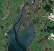
Kirkcudbright Bay 54:46'N 004:04'WCharts
Admiralty 1344Rules & Regulations
Pleasure boats to use pontoon, not Town Quay. Some berths dry outHazards
Approach up a twisting very shallow channel. Tidal streams up to 3.5 Kt.Tidal Data Times & Range
HW + 0030 Dover Kirkcudbright Bay MHWS 7.5m, MHWN 5.9m, MLWN 2.4m, MLWS 0.8mThis site is designed for slower, roaming broadband connections, like you would get at sea, so it needs JavaScript enabled to expand the text.
General Description
Contact Details:
Harbourmaster (Robbie Garside) VHF #12 & 16, Tel. No. 01557 331135 mobile 07709 479663 ... read more
Approach
Small craft mariners should be mindful of the cross tides when planning their approach. ... read more
Berthing, Mooring & Anchoring
Possible anchorages in the approach area are best seen by reference to the chart. ... read more
Your Ratings & Comments
7 comments
Kirkcudbright Harbour & Marina
Written by North Country | 22nd Jul 2025
As has been stated by others the entry & exit timing for the river is critical, however given the excellent buoyage in the approach channel & river there's little difficulty with this harbour. There's a maximum draught of 2.5m.on the outer floating pontoon. There's a protected anchorage behind Ross Island on which two leading marks form the start of the entry into the River Dee.
The Council have introduced a smartphone booking service and with your receipt come the gate entry codes.You can do it on arrival if necessary.
It's a nice sail from Whitehaven and the Isle of Man is also within a days sailing. Kirkcudbright is a lovely town and local seafood is readily available. Very helpful HM.
10m yacht on outer pontoon £36.15 July 2025
Winston Collinge
1 of 1 people found this helpful
UPDATE AUGUST 2022
Written by Don Thomson 3 | 4th Aug 2022
I reviewed these notes in August 2022. No changes apart from the addition of an image of the Lifeboat Station in the gallery and a correction to the typo in the Marina prices.
1 of 1 people found this helpful
UPDATE SUMMER 2021
Written by Don Thomson 3 | 1st Jul 2021
I reviewed these notes in July 2021. Prices have changed. The light on the Lifeboat Station has been reduced in visibility to 2M (Solar panel cannot keep it charged for the greater distance listed) Please contact the HM on his mobile to advise of intended visit.
1 of 1 people found this helpful
Update Spring 2019
Written by Don Thomson 3 | 16th May 2019
These notes were reviewed in May 2019. There were two warnings of shoal waters close to the buoyed channel. Prices have changed since we last reported. New charts have been uploaded.
1 of 1 people found this helpful
UPDATE APRIL 2017
Written by Don Thomson | 10th Apr 2017
I reviewed these notes in April 2017. You'll notice on the UKHO charts that there seems to be no shore access to the pontoon; this is incorrect. They've put their harbour dues up but it is still quite a cheap place to pull up to for the night
1 of 1 people found this helpful
Update 2015
Written by dononshytalk | 10th Apr 2015
These notes were reviewed by Don in April 2015. There have been no significant changes
Update 2013
Written by dononshytalk | 1st Mar 2013
These notes were updated on the 1st March 2013. No major changes; I've updated the prices with the 2012 prices as they don't work out the new ones until sometime in April.
1 of 1 people found this helpful

© visitMyHarbour.com | website design created by Black Culm Ltd