You are viewing the expanded version of this Harbour,
for faster browsing
use the regular version here

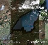
Lough Foyle and Port of Londonderry inc. Foyle Marina
Courtesy Flag
Flag, Red EnsignWaypoint
North Channel Approach 55° 13.8’ N 006° 54.25’ WCharts
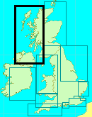
AC 2510 Moville to Londonderry AC2511 Lough Foyle AC 2798 Lough Foyle to Sanda Island AC 2723 Western Approaches to the North Channel.SC 5612 Imray C64Rules & Regulations
The buoyed channel in Lough Foyle is a “narrow channel” within the meaning of Rule 9 of the Collision Regs, so keep right and don’t get in the way of large ships. NW part of the Lough is in the Republic of Ireland, Donegal. SE part in the UK, inc. Londonderry.Hazards
The ebb tide spills out beyond Inishowen Head and in NE winds can cause very turbulent seas.The Tuns Bank extends out from Magilligan Point at the extreme NE end of which there is a lit PHM In rough weather the seas break over this bank and the NW side has been known to dry in some years.
Tidal Data Times & Range
WARREN LIGHTHOUSE -0430 Dover MHWS 2.3 MHWN 1.9 MLWN & MLWS no data MOVILLE -0350 Dover MHWS 2.3 MHWN 1.9 MLWN 1.0 MLWS 0.4 LONDONDERRY -0255 Dover MHWS 2.7 MHWN 2.1 MLWN 1.2 MLWS 0.6 See Approach and Entry for more information. (links)This site is designed for slower, roaming broadband connections, like you would get at sea, so it needs JavaScript enabled to expand the text.
General Description
Contacts
H M Foyle Port (at Lisahally) Bill McCann. VHF Channels 16,12 & 14 with Traffic & Nav info on Channel 14. Tel: 028 7186 0555.&
Visiting Vessels should contact 'Foyle Port Harbour Radio' on VHF Ch14 when in the channel advising of your intention to berth at the Marina - instructions will be given.
Lough Foyle is a large expanse of water stretching 13miles from Magilligan Point to the River Foyle at Culmore Bay and, at its widest point 6miles from the Donegal coast to the mudflats off Ballykelly. There is a well marked channel down the Donegal side which is used by large ships importing and exporting from Londonderry Port at Lisahally opposite Culmore Bay.
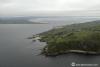
There are no harbours or anchorages on the wide SE side of the Lough until one is inside the River Foyle itself. On the Donegal side there are a couple of harbours; Greencastle and Moville, both of which are utilised by small fishing boats but have room for visiting yachts; Greencastle is an especially convenient spot for a stopover during a cruise along the North Coast of Ireland and you will find a friendly welcome there. There is a small pier at Carrickarory which is taken up by fishing boats but does have room outside for anchoring, as does Moville, but both of these anchorages are in the run of the tide which make them a) uncomfortable and b), a long row from the shore against the tide! Further along the Lough where it narrows into the River there is a sheltered little bay in behind the point to starboard opposite the old oil and chemical jetties. This is Culmore bay; it’s a pleasant anchorage, out of the main tideway, with a pub and small shop at its Western end (Ballynagard) serving a small community. You’ll often find other yachts there waiting to catch the next flood up to Derry as the river is a shoally affair and best taken on the rising tide.
The North West shore of the Lough is in County Donegal which is in the Republic of Ireland and the South East shore is County Londonderry (UK) and the two meet in the mudflats at Muff. There are no border restrictions or Customs Posts in place (2022) as both countries are part of the Common Travel Area (1922) reaffirmed by the "Memorandum of Understanding" (2019) but if you intend cruising these waters with a pet it would be sensible to ascertain the rules in force before leaving your home port.
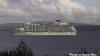
From an historical point of view the region has been steeped in conflict since Viking times; Londonderry (shortened to “Derry” by the locals) is famous for its siege in 1689 when the apprentices in Derry locked the gates against the Jacobites and the city then withstood the ensuing siege until relieved by forces loyal to King William of Orange 105 days later. Derry celebrates that siege annually to this day, the city walls and artefacts are proudly maintained and the visitor can spend many hours exploring Derry and its history. During WWII Lough Foyle was a focus for the Atlantic War, the City Airport is an old Royal Naval Airbase (RNAS Eglinton), there were two Coastal Command Airfields on the SE shore of the Lough, both of which are now disused airfields. Today’s Port of Londonderry at Lisahally was originally a small abandoned shipyard which the Admiralty was refurbishing. This refurbishment was accelerated during the Atlantic campaign and it became a hugely expanded deep water port with a tanker farm, an ammunition depot, accommodation etc all of which was scaled down after the war but has been modernised over the years to its present standard so that now the visiting yachtsman should be prepared to encounter freighters or cruise ships at any time during his passage along the Lough.
Approach
Tidal Information:
The Standard Port here is “River Foyle (Lisahally)” and....
.... the first thing to note is that High Water in Lough Foyle varies hugely along its length to Londonderry where HW is about an hour and a half later than at the narrows at Magilligan. The other notable point is that there is the vast amount of water going into and out of Lough Foyle with each tide and the streams through the Magilligan narrows can reach 3.5 kts at Springs and 1.6 kts at Neaps. There is a UKHO Tidal Diamond (B) in the middle of the Magilligan narrows which is reproduced in the Charts on this site and gives a good indication of the best time to be in these waters.
Skippers coming round from Malin Head will be glad of a counter current close in to the shore which sets Eastwards from Glengad Head two hours into the main Westward ebb tide. This is invaluable if one wants to reach the entrance to Lough Foyle as the inwards flood starts. To the West of Glengad Head the tides and streams are complicated as is the passage around Malin Head.
Coming from the East is not so bad as one can run West with ebb and time ones arrival at the narrows for the beginning of the flood but have a care if running through the South Channel (known locally as “The Dorus”) between the Tuns Bank and Magilligan Point as the ebb tide from Lough can set one to the North towards the tail of the Tuns bank. The deeper water is to the Southern side of the South Channel about 400 m off shore. If you can identify the left hand edge of the ivy covered ruins of Greencastle and line it up on 304° with the radio mast on the top of Crockaulin that will take you through the channel but lean a little to the left (about 200m) abeam Magilligan Point. It must be said that in strong onshore winds or poor visibility it would be wiser to take the longer, safer route to the North of the Tuns and come in from the Initial Fix . The saving in distance from Portrush through the Dorus is 3 miles over the outside route but could prove a false economy in adverse conditions.
Once inside the Lough the channel through to the Londonderry Pontoon in the centre of the city is narrow but well marked. The yachtsman should treat this channel as a “narrow channel”; keep to the starboard side of the channel and give way to large vessels which are restricted in their movements due to their draught. It is unwise to stray too far from this channel as it shelves rapidly outside that and passes drying banks on both hands.
The harbours and anchorages on the Donegal side provide good shelter in winds from the WSW through to North but be aware that the large expanse of Lough to the South East, and low lying land beyond that means that there is no protection from SE winds until one gets into the River Foyle at Culmore Bay.
See HERE for coverage of Greencastle and Moville
If intending passage up river to Londonderry it is a requirement to contact Foyle Port Harbour Radio on VHF Channel 14 passing Magilligan Point Instructions will be given on the marina.
The port authority website carries instructions to stop at Lisahally for harbour dues and access codes for the marina gate that is still necessary if you require shore power. The arrangement with the coffee shop no longer exists. If you are unsure about the arrangements give the Port authorities a ring for instructions to save having to go back down there to sort things out.
Berthing, Mooring & Anchoring
Alongside berths can be found inside Greencastle Harbour....
.... occasionally at Moville but in SE winds the berths on the outside of the wall there can be exposed, as will be the anchorage to the SW of it. There is an anchorage to the South West of the pier at Carrickarory but again this is exposed and in the tideway.
There is an anchorage providing good protection in Culmore Bay opposite Foyle Port
Once inside the river the next available moorings are at the Foyle Marina which comprises two pontoons 1.4 miles up from the Foyle Bridge. Here there is a single pontoon linked to the shore by a standard access bridge with a code lock. There is a portakabin with shower and toilet facilities on this pontoon. There is a further 200m long, wooden pontoon lying parallel to the river bank beyond that; it is accessed at it's upriver end separately from the first pontoon and has no facilities so make sure in your conversations with the harbour that they know that you want the pontoon with the facilities. There is a second 160 meter concrete breakwater pontoon facility, this is where the majority of large visiting vessels will moor. Full water and electric is available on both pontoons.
Although it is still possible to anchor in the river below the new Peace Bridge there is a very strong flow there and the harbour authorities are not happy for boats to be left unattended; anyway, trying to “catch up” with your boat in a rubber dinghy is not the most pleasant way to end a convivial evening ashore!
Facilities
Water and shore power are available on the pontoon - cards/tokens are available from Lisahally. The Marina is a secure, but unmanned, facility with full CCTV. Diesel and petrol can be obtained in cans from the nearby petrol station. Diesel may also be obtained from Lisahally; for that ring the HM or call on Channel 14 a couple of hours ahead whilst coming up the Lough from Magilligan; they don’t like small quantities and have a min delivery of 100 litres.
The petrol station is a short walk NE along Strand Road with a small food store collocated and there’s a Sainsbury’s a bit further along which can also be accessed from the Riverside walk. There is a chandler about three quarters of a mile away (about the same distance again as Sainsbury’s); go along the Strand to the Big Pennyburn roundabout and go left up Buncrana Road to the Springtown Industrial Estate which is the third turn on the left.
There is no facility for holding tank discharge.
Eating, Drinking & Entertainment
Derry is a large provincial City and abounds with restaurants, pubs, fast food, theaters and cinemas to suit all tastes.
For a comprehensive list of 173 pubs go to
http://www.beerintheevening.com/pubs/results.shtml?l=Londonderry&show_comments=5
In fact, just out on Strand Road, between the marina and Sainsbury’s you’ll find examples of just about everything you require; there’s even a Automotive spares shop if you need 12V spares and a Carphone Warehouse if your mobile is causing trouble.
For tourist attractions within walking distance from the marina see http://www.visitderry.com/ for full details. Golfing can be arranged via the marina allowing marina users access to some of the worlds finest Links golf courses. There is access to road and rail links to the main Irish Cities. Londonderry Airport is close to the city and has regular Ryanair flights to the main airports in the UK.
Links
Shipping Forecast
http://www.metoffice.gov.uk/weather/marine/shipping_forecast.html#All%7EMalin
Inshore Forecast
http://news.bbc.co.uk/weather/coast_and_sea/inshore_waters/13
|

Got a comment to make about Loch Foyle ? Have you found this coverage helpful ? HAVE YOUR SAY (your email address will always be kept private)
Your Ratings & Comments
Foyle Marina: 02871860313
No space availability info, overnight per meter £2.50
We arrived at Londonderry to discover that electricity/water cards are no longer available to purchase from the coffee shop just outside the marina. We were saved by the lovely local boat who had a spare card! When entering the Lough it is best to check with the harbourmaster about current situation as you might be able to stop at the pontoon in the actual commercial port to get this sorted before arriving in the Londonderry. Apart from that showers are good, and the town is lovely!