You are viewing the expanded version of this Harbour,
for faster browsing
use the regular version here

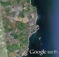
Portavogie Harbour
Courtesy Flag
Flag, Red EnsignWaypoint
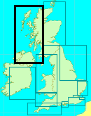
54° 27.5N 005°24.7WCharts
AC 2156 Strangford Lough & East Coast, SC5612.9A & B, Imray C62 Irish SeaRules & Regulations
Don’t obstruct the fishing boatsHazards
Plough Rocks to the South of the entrance channel and McCammon Rocks to the NorthTidal Data Times & Range
HW Dover +0016 or Belfast +0005. MHWS 4.7m MHWN 3.9m MLWN 1.4m MLWS 0.6m==The bottleneck effect of the North Channel is beginning to lessen here; expect off shore streams to be in the region of 1.5 kts at Springs. (links)This site is designed for slower, roaming broadband connections, like you would get at sea, so it needs JavaScript enabled to expand the text.
General Description
Contacts: Portavogie HM VHF #12, #14, #16 (Mon to Thur 0800 to 1630, Fri 0800 to 1530 & Sat 0800 to 1200) tel 028 4277 1470. The harbour master here is very helpful and can be contacted on
07712 074609
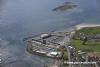
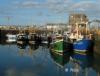
This is a busy commercial fishing port and was not set up to deal with cruising sailors. They now have pontoons in the Inner Basin fitted with water and electricity and there is generally room there for visiting yachts in amongst the crab boats.
This is all good because the harbour provides excellent shelter, entry is well marked for day & night entry and accessible in all but strong onshore winds. Have a care though - in strong Easterlies you'll be beam on to the seas whilst entering and it could be very dangerous.
Approach
It is imperative that you contact the harbour authorities to ascertain....
.... if your boat can be accepted before setting up the approach.
If you are coming from the North once you have rounded Burial Island there four navigation marks ahead and the one you want (the red can buoy off Portavogie) is the smallest; In a straight line beyond that are the pylon marker on the North Rocks, the disused light house on the South Rocks and to seaward of that the South Rocks Racon buoy.
If you have come round to seaward of Burial Island it really doesn’t matter which of these marks you pick up first they’ll all keep you clear of inshore dangers, just don’t be surprised if you finally pick up the Portavogie can buoy broad on the starboard bow later on. If you have braved the inner channel inside Burial Island it would be wise to stand out to sea a bit until you are certain of what you can see ahead because a straight line from the inner channel to the disused light house on the South Rocks (likely to be the first you see) will take you too close to the inshore dangers along the coast.
Coming from the South you can safely set course to pass inshore of Butter Paddy and the South Rocks, then outboard of the North Rocks to pass them tracking north for the Portavogie buoy.(if you can see Burial Island, just head for that and you’ll trip over the can buoy en route!)
Once you have picked up the Portavogie can buoy leave it to port and head in for the harbour mouth on a course of between 258°T and 275°T; the harbour mouth will open to port and is wide enough not to present a problem. If coming from the South and you can see the Plough rocks you can pass between them and the Portavogie PHM can staying a cable clear of the rocks. Keep a good lookout for other boats entering and leaving the harbour or manoeuvring within it and, if in any doubt at all, give them priority.
Berthing, Mooring & Anchoring
You'll be entering on a South Westerly heading and should follow the Outer breakwater past the opening for the Outer Slip before turning hard to starboard into the middle basin and on down to the far corner to turn into the Inner Basin. Probably a good idea to clear away for harbour before entering if you are short handed because the skipper will be quite busy finding his way around!
Once you have found an empty berth (with luck the HM will have been able to tell you where if you have called in advance) you'll have to go and pay him - they are charging 31p per metre (yes, that is just £3.10 total for a ten metre boat) for boats about 10 metres (I treble checked this with him) They will charge for shore power
Facilities
Water and shore power can be found on the pontoons Petrol and diesel can be obtained at the petrol station within sight of the harbour, although, being a fishing port, it may be possible to arrange delivery of diesel; they also do Calor Gas but not Camping Gaz.
As you would expect there are engineering facilities to deal with most mechanical and electrical problems. There is also a chandlery adjacent to the harbour.
Eating, Drinking & Entertainment
At the SW end and overlooking the harbour is the Quays Sea food restaurant which has good reviews; further up the road is a Chinese restaurant.
Links
|

Got a comment to make about Portavogie ? Have you found this coverage helpful ? HAVE YOUR SAY (your email address will always be kept private)
Your Ratings & Comments