You are viewing the expanded version of this Harbour,
for faster browsing
use the regular version here

Portpatrick Harbour, Rhins of Galloway
Courtesy Flag
Flag, Red EnsignWaypoint
Portpatrick Location 54:50'.5 N 005:07' WCharts
Admiralty 2198Rules & Regulations
Not KnownHazards
Narrow shallow entrance, fringed by rocks. Unsafe to enter in strong onshore winds. Night entry with local knowledge only. Strong cross tides in the approach.Tidal Data Times & Range
HW Dover +0037, Liverpool +0022 MWHS 3.8m, MHWN 3.0m MLWN 0.9m, MLWS 0.3m (links)This site is designed for slower, roaming broadband connections, like you would get at sea, so it needs JavaScript enabled to expand the text.
General Description
Contact
Harbour Master 07565102096
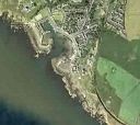
Portpatrick is small harbour with a narrow somewhat tricky entrance. It is set midway along the west coast of Galloway an area beset by strong tidal streams. Being only 14 miles away from the Irish coast, it popular with Northern Ireland boats.
At one time Portpatrick was used for commercial traffic to Ireland, but was abandoned for this purpose in 1870. It's disadvantage is facing West, and thus exposed to heavy seas which in fact smashed up the breakwaters. The remains of these will be seen either side of the close approach.
For the modern day yachtsman or motorboater, the inner harbour can offer decent shelter, perhaps except in very strong SW winds. There is enough water for most boats to remain afloat within, but the entrance channel has less than half a metre, entry and exit must be timed accordingly.
No pontoons or any other modern trappings, just the harbour walls. There used not to be much here in the way of facilities for the cruising yachtsman but in the last three or four years things have improved and the harbourmaster now has a very good reputation for helpfulness.
Plans for floating pontoons were mooted and finally rejected in 2007, which is a bit of a shame, as access from the boat to the high harbour wall is difficult.
Update 2013
The rumours that plans for 100 pontoons had been approved in 2012 are exagerated. What has happened is that the harbour now belongs to a local harbour trust having been in private ownership for a very long time. The Trust has no plans to spend money on pontoons because the present geometry of the harbour precludes this option without considerable sea defences of the same type as were wrecked way back when. They have moved the Lifeboat out of the inner harbour,are doing what they can with the NE wall and have put fenders on the ladders. The channel through the outer harbour has been dredged to 2m and a little bit of dredging has been done by the visitors wall but if you draw 2+metres you may still ground at LWS.
Approach
The Rhins of Galloway is the 26 mile long peninsular, with Portpatrick located about midway.
It is generally rocky, with tidal eddies and overfalls inshore along the coast.The South going tidal stream begins about +0430 Dover, and the North going three begins about -0310 Dover. With the tidal stream reaching up to 5 kn in places at Springs, planning is necessary. In the closer approaches to Portpatrick, tidal streams of up to 3 kn may be experienced setting across the mouth of the harbour.
If approaching from the North West there is a single plain radio mast close to the North of Portpatrick, and another radio mast set to the East, this one having dishes on it.
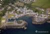
If approaching from the South, the big hotel set to the North of the harbour will be seen. The photo gallery shows both these features.
In the closer approaches to Portpatrick is it need to be borne in mind that the entrance is less than 40 m wide between the ruined breakwaters, which may well be hidden underwater at higher states of the tide. Again the photo gallery will show what a rock strewn entrance it is.
For the small craft Mariner what this means is that the leading marks that will see you safely into the harbour will need to be positively identified before making the approach. They consist of a post on the outer harbour wall painted orange (the forward mark), that lines up with the rear mark, an orange vertical stripe on the corner of the building in the main street. They line up on 050.5°. Although marked as lit occasionally, this should not be relied on.
Depths within the outer harbour are shown as low as 0.2 m at chart datum, so it would be wise to delay your entrance at least a couple of hours either side of low water, especially if there is any kind of onshore sea. In a strong onshore blow it would be wise to give it a miss altogether and to make your way round to Loch Ryan where shelter may be found.
Once through the outer entrance, a sharp turn must be made to port to avoid running up the beach. The turn must not be commenced until you have passed Half Tide Rock on your port side. This is marked by a small orange spherical buoy, that resembles a mooring buoy rather than a navigational mark.
At this stage the entrance to the inner harbour is "open", and you can make your way in.
The link we had to the Portpatrick Lifeboat station no longer works and we have been unable to find a replacement.
Berthing, Mooring & Anchoring
After making your way into the inner harbour get yourself tied up.
The Lifeboat is now moored in the small cove on the porthand side as you enter and should not be obstructed, also avoid trying to moor anywhere near the stone steps. We are told that there are now (2015) some visitors moorings in the outer harbour
Good fenders, preferably a fenderboard, and long mooring lines and springs will be needed to cope in this harbour, especially at the weekends when the harbour is stacked with yachts from Northern Island rafting four and five deep.The overnight vistors charge varies from £18 to £25 dependant on length - about £21 for a 10m boat.
The harbour master has a very good reputation for helpfulness, and if he doesn't appear you could call 07565102096, or visit their offices nearby:
Harbour Office, Portpatrick, Stranraer, Wigtownshire, DG9 8AN
The Harbour Trust now has a website which has uploaded some useful photographs of the harbour:-
Further Berthing Information
This video contains some good shots of the arrival into Portpatrick
http://www.youtube.com/watch?v=ziiDpah9kQo
On the other hand this video shows what it's like in a strong westerly blow
Facilities
Basic facilities only, water is available around the inner harbour, toilets and showers are nearby.
We are informed that they now have "electrical points all round"
The village has basic shops and post office. Calor gas can be obtained, and camping gas is available at Castle Bay caravan park, about a mile away.
The garage in Main Street, Portpatrick Filling Station, has closed but the Harbour keeps a small stock of diesel in jerrycans so if you are short they can help
Stagecoach buses link the following towns : Portpatrick - Stranraer - Girvan - Ayr, Rail connections from Stranraer. Perhaps not the best place for crew changes.
Trailer sailors will find slipways at Ardwell Point, and Port Logan, about 10 miles south of Portpatrick.
History
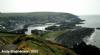
Portpatrick is a village hanging on to the extreme south-westerly tip of mainland Scotland, cut into a cleft in steep cliffs.
Dating back historically some 500 years, and built adjacent to the ruins of nearby Dunskey Castle, its position on the Rhins of Galloway affords visitors views of the Northern Irish coast to the west, with clifftop walks and beaches both north and south. The Gulf Stream, flowing in from the north, gives the coastline a pleasant climate, in which subtropical plantlife can flourish.
Industrially, the village was founded on fishing origins, with construction of the crescent shaped harbour that remains the focal point of the village today. In the latter stages of Portpatrick's history it was important as a ferry port for transport between Northern Ireland and Scotland, and handled postal mail and freight. However, in the late 19th century, when shipping became a considerably larger feature of industry, the village's vulnerability to strong westerly winds made it unviable for larger ships, and thus most of the profitable trading routes were diverted to nearby Stranraer, despite the longer voyage out of the northerly-facing Loch Ryan.
To the extreme north on the clifftop where the village's 100 year old Portpatrick Hotel stands, begins the scenic Southern Upland Way to Cockburnspath on the east coast.
Today the village retains a fleet of fishing craft, and a lifeboat is still stationed in Portpatrick. There are bowls clubs, a very active golf club (Dunskey), many guesthouses and hotels, and rustic public houses.
The text on this HISTORY page is covered by the following licence
http://en.wikipedia.org/wiki/Wikipedia:Text_of_the_GNU_Free_Documentation_License
Eating, Drinking & Entertainment
Portpatrick offers opportunities for the sailor who enjoys his golf too. The big hotel above the harbour has an excellent pitch and putt course, while there are nearby golf clubs.
Otherwise the small village can provide a few pubs and hotels, one of which is right on top of the harbour.
The energetic will find plenty of difficult and less difficult coastal walks, while being rewarded with spectacular views.
Links
|

Your Ratings & Comments
I entered about an hour before spring low and saw 1.8m in central channel, but may not have taken the perfect line.
Whichever way you look at it, the entrance is narrow and between scary looking rocks. I would not fancy coming in with any onshore wind.
Coming into the harbour, turn to port and ignore the port hand harbour housing the lifeboat and go into the inner harbour. This was over 2m but involved tying up on a big stone wall. There are large fenders guarding the ladders, but nothing between. Immediately upon tying to the ladder to enable ascending and putting lines in place, my bow was scraping the limpet covered stone.
Long story short, you need to carry quite a bit of rope up 20 feet of rusty iron ladder so this can be tied off as far from bow and stern as length allows then throw this back down. Being single handed, this was an operation in itself and luckily I brought a rucksack which I could carry the ropes in. There is no facility to tie lines which would move up and down with the tide, so however you tie up, you will drift into the harbour at high tide. I don't know how I would have handled this if I had arrived at high tide, beyond ensuring I was able to re tie lines at low.
This was spring low, so entering at high tide would be a different experience.
There is electricity all around the harbour and a shower and toilets.
10.5m is £28 payable by bank transfer.
The height of the ladders at low tide should be borne in mind as you need to be fit and, crucially, have a head for heights - which I don't!
I would avoid this harbour if single handing or if you don't like heights, but it is sheltered and the only port of call in 25 miles of the mull of Galloway. If you are rafting then I expect the experience is very different.
The inner harbour has been dredged to a minimum depth of 2m so no risk of running aground in my 1.8m draft yacht.
The ladders are spotlessly clean - no more pigeon pooh on your hands as you climb!
There is now effective fendering at each ladder so the gelcoat wasn't at risk.
We had a superb meal at the Waterfront Bistro and a few drinks at the next door Crown Bar - a lively singer was performing and we thoroughly enjoyed our evening.
I spoke to the harbourmaster by phone before sailing over and he was extremely helpful. A community association now runs the harbour - well done! It is now a decent destination for yachtsmen and I hope they benefit from an increase in visitor numbers. It is a great weekend trip for boats from N. ireland or a passage stop for those doing the W. Coast of Scotland.
Da Jamibeg'r
The village was very quaint and we had a superb meal at the Waterfront Bistro.
Pest control for the pigeons, some dredging and a small investment to make the harbour wall more accessible would go a long way to encourage yachts to access this very attractive village