You are viewing the expanded version of this Harbour,
for faster browsing
use the regular version here

Rothesay, Port Bannatyne and Anchorages Around Bute
Courtesy Flag
Flag, Red EnsignWaypoint
None givenCharts
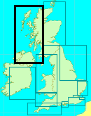
Admiralty, 1907 S.Bute, 1906 N.ButeRules & Regulations
UnknownHazards
No Particular Hazards. Tide can reach up to 3 knts in the narrow passages of the Burnt Islands.Tidal Data Times & Range
+0100 Dover MHWS 3.6m, MHWN 3.1m, MLWN 1.2m, MLWS 0.6m Note: The flood tide enters W.Kyle and E.Kyle from seawards and meets up around the Burnt Islands. (links)This site is designed for slower, roaming broadband connections, like you would get at sea, so it needs JavaScript enabled to expand the text.
General Description
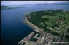
Rothesay harbour nestles in Rothesay Bay on the East side....
.....of the Isle of Bute facing north-east and giving perfect shelter from all westerly winds. Rothesay Sound forms the entrance to East Kyle and Loch Striven and is not at all far from the yachting centres of Largs, Inverkip, Holy Loch, and Rhu.
The small town offers all the facilities expected, and indeed was once a popular holiday location in it's own right.
The Isle of Bute can be circumnavigated with ease by pretty well all yachts, there are numerous anchorages and several enterprising hotels lay out moorings for visitors. This article also touches on and provides charts some of those anchorages, namely Kilchatten Bay, Kames Bay (Port Bannatyne Marina)), Burnt Islands, An Caladh, St Ninian's Bay, Scalpsie Bay, and Inchmarnock Island.
Approach
Entry to Rothesay Bay is straightforward enough,
It is well charted and lit heavy mooring buoy resides in the middle of the bay.
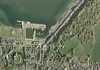
The town and harbour of Rothesay are at the southern end of the bay. The harbour itself is entered at its eastern side, take note of the red can buoy (Fl.R) marking shallows and leave it to port when entering. Best water closer to the E.Pier rather than the shore.
International traffic signals are shown, three vertical red lights mean that the harbour is closed to all movements, and three vertical green lights mean that the harbour is open.
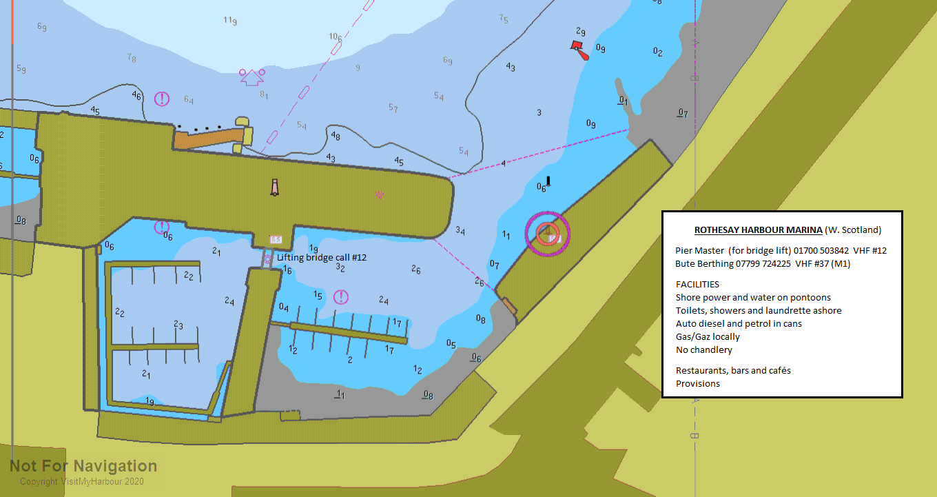
There are berths available within the harbour either in the outer basin, or underneath a lifting bridge and into the dredged inner basin. The lifting bridge stays closed whenever a ferry is in.
Another less protected pontoon is located behind the Western extremity of the pier.
Small craft should find room to anchor around the west side of Rothesay Bay, somewhere near the Isle of Bute sailing club. (Water can be obtained here).
Berthing, Mooring & Anchoring
Anchorages around Bute...anti clockwise from Rothesay.
Port Bannatyne Marina, Kames Bay 01700 503116

They have a website:
Ashore you'll find in the small village three pubs (two serve food), a cafe, a post office, and a golf course. There are no ferries to disturb the peace at this location. The problem here is its remoteness; the village is at the end of a ribbon development along the coast from Rothesay and is entirely a dormitory village for the larger town
Burnt Islands..(and Colintraive)
To get up to this corner of Bute you will either have come up the East Kyle or the West Kyle. Unless you come and go via the East Kyle you will have to negotiate your way through the Burnt Isles which you will find entertaining. Tidal streams in East Kyle are almost non existent until you get to Colintraive but up the West Kyle you will start to experience them once past Tignabruaich when you will want to be running with the flood.(up to 2 kts springs). Around the Burnt Isles the West going stream occurs 2.5 hours before HW and the East going 5 hours after HW so you need to plan to pass Rubha Ban just before half flood, getting to the Burnt Isle channels just before the turn. If you leave it much later you can hit adverse tides of up to 5 kts at springs. It is immaterial which channel you use through the Burnt Isles but we would suggest that, if you have an engine available, it might be an idea to have it idling because the winds here are fickle and one can be taken aback in the blink of an eye - which in a narrow tidal channel can be exciting to say the least. The northerly short channel is easier to navigate (just split the two sets of buoys) but can look a bit like a lively trout stream whereas the southerly one is a bit twisty and involves some line of sight pilotage to be safe, but has less current.
Be aware of the Calmac Ferry operating between Bute and Colintraive. Although it's free floating (ie not a chain ferry), it works to a timetable so tends to hoot rather than give way. It's a far cry from the old LCT that used to potter back and forward in my youth when it had some cars to carry
Again the small craft anchoring areas are well shown on the large scale chart provided. Bit exposed to the west or northwest. In these cases the northern anchorage tucked in behind Eilean Buidhe will prove superior.
There are Hotel moorings at Colintrave available to customers, 5 x 15 tonne & 1 x 60 tonne clearly marked mooring buoys with pick ups, to north of ferry ramp. Showers available £2.50 (bring your own towel). If you have dinner at the hotel (well recommended by the writer) the mooring is free otherwise it's £20.00 per night. There is a small village shop with the basic essentials Telephone 01700 841207.
2021 no showers for this summer but hope to have them available again for 2022
Anchorages on the west side of the W.Kyle are covered elsewhere.
Inchmarnoch an St Ninian's Bay..
Again the anchoring spots are shown clearly on the chart provided, off Midpark farm on the east side of Inchmarnock, or in St Ninian's Bay, being aware of the drying rock rocks near the landing on the west side of the bay. Reasonable depths to anchor in will be found either of these places.
Scalpsie Bay...
Wide open to the South West, but could provide good shelter from NW winds.. Best anchoring spot shown on the chart once more.
Kilchattan Bay
On the eastern side of Bute. This has a small village with a Hotel, and the head of the bay dries out extensively. Opposite the village the depths drop-off very sharply into deep water, but in the northern half of the bay reasonable depths for anchoring will be found.
St. Blane's Hotel in the village has changed hands and the new owner is trying to get funding to lay some buoys but, for the moment there are none there for visitors. Their telephone number is 07507 559621. There are three old piers, with the one W. of the Hotel being the refurbished for landings.
The bay is exposed to the east, but can offer reasonable shelter in westerlies.
Rothesay
There are no longer any visitors buoys laid out in Rothesay Bay. If you wish to lie to your own tackle you should be able to find good holding to the NW of the Pier complex.

Within the harbour there are now 100+ pontoon berths, 68 in the dredged inner harbour marina reserved for overnight berthing, while the other 40 in the outer harbour and behind the Western pier can be used for overnight berthing or shortstays. There is shore power and water to the Inner and Outer harbour pontoons but not on the Western Pontoon.
2022 The berths in the outer harbour are not available for use at the moment.(August 2022) with a bit of luck they may be open for the autumn of 22
The inner harbour berths can only be accessed when the lifting bridge is opened. This is in the charge of the Pier Master call on VHF channel 16 or 12 or telephone 01700 503842. The bridge will remain shut when a ferry is alongside the pier.
All the moorings around the harbour and all the berths within the harbour are under the control of Bute Berthing who can be contacted on VHF#37 (M1) or 07799 724225 . Their website can be found at:
http://www.buteberthing.com/
The charges (2022) within the harbour work out at £28.00 for a 10m boat with shore power thrown in. Shortstays are charged at £6.00 for four hours.
There is a considerable number of creel boats and other assorted commercial fishing boats in the inner harbour so it does not present a "leisure" outlook; it's very tight and looks "grubby"
Facilities
The facilities (or lack of.. ) around the individual anchorages have been touched on, these paragraphs deal with what is available at Rothesay.
If within the harbour, water and electricity are available at the pontoons or at the pier. Showers at the Victorian toilets £1.50. Free WC at ferry terminal. 24 hour facilities at the marina coming soon, but how soon is still unknown (even to the berthing Company!) Until such times as separate amenities are provided the visiting yachtsman will be sharing facilities with the general public.
Petrol and diesel are available in the town by jerry can, although it may be possible to arrange a tanker for larger quantities. Calor gas & Camping Gaz is available.
The town can provide a reasonable range of shops for provisioning, post office, bank and chandlers. There are boatyards capable of repairs in Kames Bay. Transport is by ferry to the mainland.
History
The town of Rothesay is the principal town on the Isle of Bute, in the council area of Argyll and Bute, Scotland. It can be reached by ferry from Wemyss Bay which offers an onward rail link to Glasgow. At the centre of the town is Rothesay Castle, a ruined castle which dates back to the 13th century, and which is unique in Scotland for its circular plan.
History
Rothesay is the county town of the former county of Buteshire, which included the islands of Great Cumbrae, Little Cumbrae and Arran. The former county buildings, now partially closed down, overlook the castle.
During the Victorian era, Rothesay developed as a popular tourist destination. It became hugely popular with Glaswegians going "doon the watter" (lit: down the water, where the 'water' in question is the Firth of Clyde), and its wooden pier was once much busier with steamer traffic than it is today. The town also had an electric tramway - the Rothesay and Ettrick Bay Light Railway - which stretched across the island to one of its largest beaches. However, this closed in the mid 1930s. The centre of activities was the Winter Gardens building (built 1923) which played host to some of the best known music hall entertainers of the day.
The impressive bauhaus-inspired pavilion of 1938, stands-out on the seafront.
From the 1960s onwards, with the advent of foreign package holidays, Rothesay's heyday was largely over. The Winter Gardens closed and lay derelict for many years. However in the 1990s, it was redeveloped and is now a tourist information and exhibition centre.
Duke of Rothesay
The heir to the British throne is known as the Duke of Rothesay in Scotland. This practice was begun by Robert III, who regularly resided at Rothesay Castle, and first granted the title to his son David in 1398. The title was given to the heir of the Scottish throne until the Union of the Crowns in 1603. Unlike the equivalent English title of Duke of Cornwall, there is no land attached in the form of a Duchy. The main landowner on the island is the Marquess of Bute, whose principal seat, Mount Stuart, is located a few miles to the south.
Sport
The most successful sporting club on the island is Bute Shinty Club who play at the highest level of the sport (the Marine Harvest Premier League). In 2006 Bute won promotion to the Premier League by winning the South Division One. Bute also won the Ballimore Cup and were runners up in the Glasgow Celtic Society Cup in 2006.
The town has a senior amateur football club called Rothesay Brandane F.C. who play in the Caledonian Amateur Football League, and an under 15 youth team called Rothesay Brandane Rovers who compete in the Paisley & District Youth League.
The island has three golf courses, one of which is situated on the outskirts of the town, the 18-hole Rothesay Golf Club, another, the 9 hole Bute Golf Course, near the sands of Stravannan Bay on the west coast of the island, and the other, the rather unusual, 13 hole Port Bannatyne Golf Club, situated on the hills behind the village.
The town hosts the High School of Glasgow rugby camp every summer.
The text on this HISTORY page is covered by the following licence
http://en.wikipedia.org/wiki/Wikipedia:Text_of_the_GNU_Free_Documentation_License
Eating, Drinking & Entertainment
No shortage of watering holes here for the thirsty crew, with around a dozen pubs in the town many of which serve food ... check them out with this link:
http://www.beerintheevening.com/pubs/results.shtml/el/Rothesay%3BIsle%20of%20Bute/
Dedicated restaurants including Indian and Chinese:
Restaurants & Places to Eat in Rothesay 2022 - Tripadvisor
For those of you who enjoy fishing the fly there used to be good brown trout in Quien Loch above Scalpsie Bay but you need a permit which can be obtained from Bute Estate Office Tel: 01700 502627
Links
|

Your Ratings & Comments
Caladh Harbout, on the west side of the entrance to L Riddon, is another good anchorage in 3-4m, but is tight when there are >3 boats in there. Holding good.
Rothesay: Anchorage from 250m west of the ferry ramp as far as the yacht club building is good, though avoid the few private moorings there (or use trip line). Holding is OK.
When approaching or leaving give the harbour master a shout on CH12 and they will change the lights if they are able. They are very friendly and go out of their way to help where they can.
If there is noone around the gate code is at the top of the ramp and the Bute Berthing Company office has an honesty box (it's a small yellowish kiosk next to the bus stop by the inner harbour).