You are viewing the expanded version of this Harbour,
for faster browsing
use the regular version here

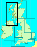
Stornoway and Loch Tarbert
Courtesy Flag
Flag, Red EnsignWaypoint
58° 11.15N 006° 21.6WCharts
AC 2529-1 Stornoway Harbour; AC 2529-0 Approaches to Stornoway; Imray C67 North Minch and the Isle of Lewis (with harbour plan for Stornoway). There is no Admiralty Leisure Portfolio for StornowayRules & Regulations
Must call the Harbour on VHF #12 before entryHazards
Beast of Holmes Rocks off Holm Point (now has an SCM) and the Chicken Rock off Chicken Head. There are shoals within the harbour area marked by perches. The channel to the West of the marina is marked by two red pylons which are lit at night – it’s quite narrow.Tidal Data Times & Range
HW Stornoway is 10 minutes before HW Ullapool. MHWS 4.8m MHWN 3.7m MLWN 2.0m MLWS 0.7m (links)This site is designed for slower, roaming broadband connections, like you would get at sea, so it needs JavaScript enabled to expand the text.
General Description
Contacts
Stornoway Harbour Master VHF 12, tel 01851 702688,
Stornoway, situated on the North Eastern side of the Isle of Lewis, is well protected from the prevailing SW winds and the marina itself, tucked right up in its north western corner is pretty well sheltered from anything the weather can throw at one in these latitudes. Mind you running into here on a South Easterly gale would be interesting until one was well past the Calmac ferry pier.
The harbour is the raison d’être for Stornoway; it’s the main terminal for the Calmac Ferry to the islands of Lewis and Harris (although there are other options serving the islands to the South) and, of course was a fishing port through the heyday of the herring fishing.
There has been a settlement of sorts here since pre history and various clan leaders (since the Vikings) have fought to capture and control the town and the island; until the 1920s the island was “owned” by a series of clan chiefs and finally an English land lord (Lord Leverhulme) who finally gave up on getting his own way and gave the island back to its inhabitants.
Today the town is the centre of Government for the Islands, it’s a tourist hub and location for landing catches (though many fishing boats prefer to land their catches on the mainland at places like Loch Inver, Kinlochbervie, Ullapool and Gairloch)
In recent years Stornoway Port Authority has caught onto the fact that there is a thriving cruising community and has improved the facilities for the cruising yachtsman. This means that one can come across sailors from many European countries as well as the usual collection of English and Scottish cruisers who love this cruising ground. The town has everything one needs to victual and bunker yachts of all sizes and the marina is, as has been said, very well sheltered.
They are dredging the bay behind Goat Island (ie between the Power Station and No 3 Pier) in preparation for a new marina. This work is expected to last until midwinter 2019/2020.
2021 The new Marina is now available, called "Newton Marina". We have changed the visichart in the Gallery and added a new chartlet in the berthing and anchorage section. They advise that the Inner Harbour marina is used for short stops as it is more convenient for the town.
Their website can be found at Leisure (stornowayportauthority.com)
Approach
Whatever direction you approach from you are required to call the Port on #12....
.... to find out the movements of any large ships they may be working and to get a marina berth allocation or get permission to anchor in the outer harbour.
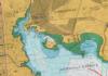
From the South the approach is very clean; the first thing you will pick out is the huge tower at the Cnoc nan Uan War Memorial which is at the top NW corner of AC 2529-1 and after that the large Arnish Sheds on Arnish Point can be identified (they are painted a light shade of pastel green) . About a finger’s width to the right of this you can pick out the lighthouse on Arnish Point and eventually the red can buoy off Arnish Point. If you are unlucky there may be a cruise ship anchored to the South of Arnish point which will obscure it (be aware that during your approach this will swing on the tide which will give the impression that it may be about to leave, but a call to the harbour authority on Channel 12 will soon clarify that). Once you round that buoy at Arnish point the harbour opens before you.
From the East and North East you will not see much to be identified until you pass abeam of the SCM at Chicken Head. Be aware that if coming from the NE (Cape Wrath) Eilean a’ Chrotaich will be seen as separate from the Eye Peninsula and that the Chicken Rock is beyond that. From Chicken Rock you should be able to see the Arnish Sheds against the dark background of the island and can aim for those until the harbour opens as you pass Holm Point which now has an SCM (we have shown this on the charts in our gallery)
From either direction, once in the harbour, look to the North West and identify the prominent Calmac terminal which you will eventually round into the marina but you cannot head straight for it at this stage due to the shallows off Eilean Gobhar (Goat Island). Shape a course close to the green SHM (depending on your draft and the state of the tide) and thence pass close(but not too close) abeam the Calmac Ferry Terminal. There is a new yellow Special Mark just to the SE of No 3 pier but that should not impede your progress. There is now a new green Navigation light on the end of Pier No 2 withing the Ro-ro complex. This means that on your approach there are places where you will be able to see the Q(2)G.10s on the end of pier 3, the new Fl G 3s on the end of Pier 2 and possibly the green sector sector of the light on the end of Pier 1 which is a Q.WRG. Depending on the state of the tide you should be able to give the Esplanade Quay sufficient offing to be able to see any fishing boats departing from the North Beach Quay, but be aware that you won’t be able to see their masts above the Quay and should be ready to take avoiding action (you would be the burden vessel to anything coming out from behind the quay)
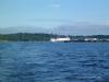
Once around that corner the marina becomes obvious and you will probably have been allocated a berth on or close to one of the hammer heads. You will have some decisions to make at this stage. The approach channel is close bounded by shallows on the Western side which are marked by two red poles (lit at night) which can be seen on the photo in our gallery. It will be your choice on which way to tie up - depends on the wind, your turning circle and the state of the tide because at low tide there is not a lot of room to turn round. If there is a strong SE blowing you may well have to resort to passing a bow line and allowing the wind to take the stern round to tie up port side to. All part of life’s rich pattern for the sailor!!
Berthing, Mooring & Anchoring
Most visiting yachts opt to enter the inner marina as it is in the heart of the town and nearer the shops and hosteleries. The new marina is intended for the long stay/permanent boats.
You will be allocated a berth at some stage in your approach. In 2022 they are charging £2.92 pmpn which includes shore power and showers and VAT. They are very yacht friendly here and where ever possible the HM will meet you and help you tie up; he will also have a visitors pack for you which, in 2015 included a miniature of the local malt!! If you open the link to their web site (in our General Description section) you can download a copy of their handbook but in case you have a ropy internet connection there is a chart of the marina layout in our Navigation Gallery.

Alternatively you may choose to anchor. There is good shelter in Glumaig Harbour behind Arnish Point and, in Northerlies, you would be sheltered in Mol Sandwick but, we are told it is a “bit exposed” there. In neither location will you find much in the way of services close ashore. The HM has advised us that you would still be required to call them on #12 to advise of your intentions.
Facilities
As has been said, this is a very yachtie friendly harbour. The marina dues are inclusive of shore power and showers. Some of the facilities are of the portacabin variety but they hope to have a custom built marina facility in due course. They have diesel but petrol will have to be obtained from a local garage - which is a fair walk away but, never fear, if you ask nicely one of the harbour staff will turn up and give you a lift in the harbour pick up. Calor and camping gas will also have to be obtained from the garage and, beware, the prices are astronomic for Camping Gaz.
There is a chandlery close to the HM's office but it tends to stock for large ships rather than for yachts.
There is a page in the harbour year book which gives directions to everything you need.
marina-handbook-0820-a5-digital.pdf (stornowayportauthority.com)
Eating, Drinking & Entertainment
The Harbour Year Book advertises all the good restaurants and there are plenty of watering holes. Fresh fish is available on the quayside opposite the marina gate. There is a large Tescos not too far away. If you want a bit of Harris Tweed this is the place to get it in the shape of small gifts to full blown suits/jackets.
The Hebridean Celtic Festival is in July and the 2022 event will be from 13th to 16th July - there’s music on every corner of the town and in every pub and if you are cruising these waters it’s well worth adjusting your timings (weather permitting) to arrive here for that (or to miss it depending on your tastes!)
Links
|

Got a comment to make about Stornoway ? Have you found this coverage helpful ? HAVE YOUR SAY (your email address will always be kept private)