You are viewing the expanded version of this Harbour,
for faster browsing
use the regular version here

Strangford Lough Anchorages
Courtesy Flag
Flag, Red EnsignWaypoint
None GivenCharts
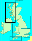
AC2156 Strangford Lough and East CoastRules & Regulations
Absolutely no rubbish or fuel in the Lough please. Landing on some of the islands is prohibited in the breeding season (March to August). A licence is required for salmon and trout fishing; no licence needed for “sea” fishing but if salmon or trout are caught they must be returned to the water (dead or alive). Also be on the lookout for oyster beds and don’t anchor over them.Hazards
Many just awash rocks and pladdies. See General description.Tidal Data Times & Range
The tidal range within the Lough varies the largest being about 4m at springs to 2.5 at neaps. HW varies on Belfast from about 15mins after at the entrance to nearly 2 hours after further into the Lough....Expect streams of up to 2kts within the Lough in the main channels and in the squeeze spots between some islands. (links)This site is designed for slower, roaming broadband connections, like you would get at sea, so it needs JavaScript enabled to expand the text.
General Description
Contacts: Strangford HM at Ferry Terminal VHF #12 #14 tel 028 448 1637.
Strangford Lough is a huge expanse of enclosed water which is a beautiful cruising ground in its own right; you could very easily make this your “holiday destination” from England. There are piles of yacht clubs (big and small), loads of places where you can anchor and take your ease and it’s only four or so miles from one side to the other. It’s rather like the Scillies in that you can have lunch in one place, have a snooze and then potter somewhere else for the evening; the main difference is the backdrop and it’s much less exposed than the Scillies. The other thing is that once you have braved the narrows inbound it would be a shame to turn round and go straight back out without stopping to sit down and enjoy yourself without any harbour dues !
On top of that, although it looks a difficult place to navigate around, the art of “transits” will serve you well – draw transit lines on your chart which will keep you clear of charted dangers ie “when I can see the edge of that island round the edge of that one I’ll be clear of that hidden rock”; it works a treat both in the Scillies and here! The chartlet of Part of Strangford Lough includes the listed transits shown on the chart with their circled letter designation but you will soon work out more of your own as you potter around.
We have shown the more well known anchorages below along with the navigation and facilities where known; if you know of others please contact us with the details.
Hazards
The whole lough is a feature produced by a retreating glacier at the end of the last ice age. The melting ice has left deposits in its wake producing an extremely undulating sub surface profile which can be seen at the surface as a multitude of islands and rocks (some just below the surface). The AC 2156 chart is a very good representation of this but, if using a GPS remember the WGS84 offset. The rocks and islands (called “pladdies”) are often marked by poles or perches (our chart, below, has emphasised the known ones) but these merely indicate the presence of an hazard, not it’s extent; as these poles are not officially maintained they should not be used as navigation marks or channel indicators but only as “ ‘ere be dragons” warnings.
We would strongly suggest that if you are intending to visit the Lough on your travels it would be a good idea to produce some laminated blow ups from the "members only" zoomifiable charts on our web site; beats a soggy chart and a magnifying glass any day.
Other Contacts
Portaferry Marina
028 4272 9598
http://www.portaferrymarina.co.uk/
Quoile YC
028 4461 2266
http://www.quoileyc.com/
Killyleagh YC
028 4482 8250
http://www.killyleaghyachtclub.co.uk/
East Down YC
028 4482 8375
http://edyc.co.uk/
Strangford Lough YC
028 9754 1883
http://www.slyc.co.uk/
Down Cruising Club
http://www.downcruisingclub.org/
028 9754 1663
Kircubbin Sailing Club
028 4279 8050
http://kircubbinsailing.club
Ringhaddy Cruising Club
http://www.ringhaddy.co.uk/#%21visitors
Approach
The passage through the “Narrows” has already been dealt with in our article at
.jpg )
If you click on this chart to the left it will open in a separate window. It's my old chart which highlights the poles and shows some of the routes
After that it’s a case of where to go first. If this is your first visit, or you are short handed, it would be advisable to be under engine before entering the Narrows and prepared to either anchor or pick up a mooring as it’s possible that you will be unable to find an alongside berth unless you have rung ahead and booked. You may want to stop first at Portaferry on the starboard side or continue up to Ballyhenry Bay; whichever, remember that you are being effected by the tide so that your turn into the current to anchor will be elongated to such an extent that if you leave it too late you won’t even be able to make it back to where you want to anchor!! For Ballyhenry leave the Walter Rocks (marked by a pole) well to starboard (also avoid the Turbine marked by four yellow buoys) and ahead to starboard you will see some yachts at permanent moorings in the bay; you should anchor clear of these opposite a cottage in the trees. You will find good holding in about two and a half metres on clay/mud and clear of the main tidal stream; none the less it would be wise to set an anchor watch until the tide has turned, or at least be back on board to see how she settles. You should be able to pick out a gap in the wall along the road which is a good place to land. There are no facilities ashore in the bay; you’ll have to walk into Portaferry where there is good selection of shops etc.
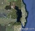
Google O/H link for Ballyhenry Anchorage
The next anchorage up the East side is in Kircubbin Bay. The route is clearly marked on chart 2156-0 but here is a list of waypoints of the junctions to help.
D/E opp Ballyhenry Point 54° 23.596N 005° 35.373W
F/E opp Abbey Rock 54° 25.839N 005° 35.665W
F/G opp Long Sheelagh 54° 27.012N 005° 34.906W
Sandy Rock Pladdy 54° 28.104N 005° 33.262W
Entrance to Kircubbin Bay 54° 29.474N 005° 33.067W
The first thing to note is that you need to set off from Portaferry or Ballyhenry Bay somewhere in the middle of the flood tide because there are spots on the route where the stream can get up to 2kts ebb/flood. The trip will take 1hr 30m to 2hours depending on your boat speed. Watch out in the area opposite Don O’Neil Island and Limestone Rock where you may find you are set a bit to starboard.
Split the gap between the WCM & ECM at Craigyouran and Long Sheelagh and head for the SHM at Hoskyns Shoal giving the SCM at Tip Reef a cable and a half offing. On the chart at that point you will see a note saying "See View B" - you'll find that view on the West side of the chart. Turn onto Northish (005°T) at Sandy Rock Pladdy and head for the gap between the Port & Starboard marks just under a mile ahead.
Right, having sorted out the correct bay, (helpfully indicated by other moored yachts!) you should aim to anchor either at the north end of the bay (where there is a boat club slip for landing) or you may find that there is enough water here (HW is about 3m above LAT) for you to go alongside the town quay in the middle of the bay, especially if you can take the ground and you need fuel (which is at the South end of the village).
The pier wall is rough rock so you’d better use a fender board. If you anchor close to the Sailing Club slip, they have water and showers which you are welcome to use. The village is about a mile from the Sailing Club and has a good selection of small stores and pubs. If you find you have a load of shopping to carry back there is a bus along the foreshore road which would save you the walk with it; bus times can be found at:-
http://www.translink.co.uk/Services/Ulsterbus-Service-Page/Timetables/?spn=&spns=&lrn=10
Google O/H link for the Kircubbin Bay Anchorage
This is the only place on the East side of the lough with a viable anchorage; the rest are all on the West side. On the West side of the Lough opposite Kircubbin Bay are the anchorages of the Down Cruising Club and the Strangford Lough Yacht Club separated by Sketrick Island. How you get here depends on where you start. We used to advocate a route through the pladdies to the West of Kircubbin Bay but the poles and twigs on those pladdies are no longer there so you'd have to be very careful to get through there nowadays.
If you are coming up from Portaferry the route is well marked though there is no reason why you shouldn’t cross from Dead man’s Rock ECM to pass north of Trasnagh into the anchorages. It also possible to take a short cut North from Abbey Rock to the gap between Janes Rock and Long Sheelagh, then on between Sand Rock and Dunsy Rock turning to port for the gap between Dunsy Pladdy and Green Island (leave this turn until Gull rock is in line with the house on the South end of Dunsy Island to clear the shoals north of Dunsy Rock). Then continue NNW to pass close to the NE end of Darragh Island and on to Braddock Rock.
The route from the South through Ringhaddy Sound will be dealt with further down.
The anchorage at Down Cruising Club, known as Ballydorn, is fairly narrow and the tide can run through there at up to 3kts so it’s best to turn up at slack water. They have a pontoon alongside the Lightship and facilities for visitors. Note that here they do make a charge for your stay.
The Strangford Lough Yacht club next door in White Rock Bay also welcomes visitors and often have a spare mooring. Their pontoon has 1.2 metres at its outer end with shore power and water. Toilets and showers are available in the Club House where there is also a restaurant which is open at the weekends.
The nearest shops are in the village of Balloon and on Sketrick Island can be found the famous Daft Eddy’s pub ((028) 9754 1615) which should be visited at least once before you leave the Lough.
The next anchorage down the west side of the Lough is in Ringhaddy Sound. There are two or three of ways down to here from White Rock Bay the inshore route between Darragh Island and Parton Island straight into the Sound, or the long route via the main channel or you could thread your way down through the middle; that’s the fun of this place, it depends on the wind, the time, the tide, your draft and most of all your inclination, as to which way to go! If making for here from Portaferry just leave the AC route E at 54°24.98 005°35.55 and make for the Sound which will be obvious from the forest of masts (the ruined windmill at Killinchy which the chart shows as a guide can no longer be seen.)
The Ringhaddy Cruising Club resides here and has pontoons for temporary mooring where there is both power and water.
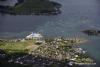
Overhead shot of Ringhaddy Cruising Club
And so to the SW corner of the Lough where there are lots of lovely places to stop either for the night or just for the afternoon; the main ones are the East Down Yacht Club, the Killyleagh Yacht Club and the Quoile Yacht Club. These all have pontoons and club houses with bars and showers but availability of pontoons and moorings during the summer weekends should not be taken for granted; where they are available all the yacht clubs are happy for visitors to use them and if they are not available then there is normally room to anchor near them.
Entrance to the East Down Yacht Club is best made from the SE the first time although there is a very narrow channel in from the North to the West of Island Taggart. The narrowness of the Northern entrance channel can be seen in the Google Earth link below; it’s best taken on a rising tide, watching the echo sounder all the way. The pontoon at the EDYC is accessible above half tide.
Google Maps East Down Yacht Club
There is also a pleasant spot to anchor between Castle Island and Island Taggart but be aware of the spits stretching out to the SE from Castle Island if departing to the North.
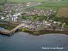
Entrance to the roads at Killyleagh poses no problems, the anchorage is to the South of the Town Rock, but you may be lucky and find that they have a mooring spare or a slot on their pontoon. There is a substantial town behind it with access to shops, banks, pubs and restaurants. It also has internet access available at the local Library.
Google Overhead view of Killyleagh
The approach to Quoile Yacht Club is a little narrower further along the shore to the South. If coming in from the Narrows the safest route is to the north of Skate Rock and Rigg as there is a scattering of rocks between them & Green Island. The Rigg itself can be hazardous as its pole is one of the locally maintained ones and cannot be relied upon. After that the channel is well marked and you should leave Toad Stone to starboard and watch out for a buoy marking a drying rock close to the north of the club pontoon which is topped by an ECM. Their pontoon has 3m alongside for loading and off-loading supplies and they have moorings for visitors further out into the pool.
Google Overhead view of Quoile yacht Club
Facilities
All the anchorages mentioned above with the exception of Ballyhenry have yacht clubs along with the facilities you would expect of them. Killyleagh and Kircubbin are the only ones with a village/town within a short distance where supplies (& cash) may be obtained. If planning an extended stay in the Lough it may be wise to drop in to Portaferry on arrival to top up on supplies and fuel. It’d probably be a good idea to call in at somewhere like Killyleagh early in one’s perambulation around the Lough and pick the clubs’ brains for information on where to go.
There is nowhere in Strangford Lough (or at Portaferry) to pump out your settling tanks so do that at sea before you start your approach; remember that the whole Lough is a conservation area of one sort or another so depositing your effluent into the lough is a definite no-no.
Eating, Drinking & Entertainment
Most of the Yacht Clubs have bars/restaurants but these are not available every day of the week so you should contact them when you are thinking of using them.
There is quite a bit of info on this website
Strangford Lough - 2021 All You Need to Know Before You Go (with Photos) - Strangford, UK | Tripadvisor
Links
|

Got a comment to make about Strangford Lough ? Have you found this coverage helpful ? HAVE YOUR SAY (your email address will always be kept private)