You are viewing the expanded version of this Harbour,
for faster browsing
use the regular version here

Plymouth, the Rivers and Anchorages
Courtesy Flag
Flag, Red EnsignWaypoint
None GivenCharts
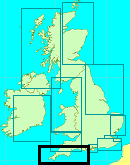
Admiralty 871, SC5602 SC5912Rules & Regulations
Keep at least 50m, from moored Navy Ships/ Property. 100m from Submarines. Give Way to Chain FerriesHazards
Busy Naval Dockyard HamoazeTidal Data Times & Range
HW Dover-0540 MHWS 5.5m MHWN 4.4m MLWN 2.2m MLWS 0.8mThis site is designed for slower, roaming broadband connections, like you would get at sea, so it needs JavaScript enabled to expand the text.
General Description
Getting away from the main centre of Plymouth there are many opportunities......
..... for the adventurous to seek out peace and quiet, and a shoal draft boat although useful is not necessary.
To the eastern side of Plymouth proper lies the Cattewater, which houses Plymouth Yacht Haven, as already described in the main Plymouth article. The Cattewater is not navigable too far before it is blocked by a low bridge, and therefore does not provide much of an opportunity for exploration.
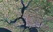
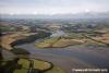
The Western side of Plymouth proper feeds into an area known as the Hamoaze, which is home to the Navy dockyards, and also contains a couple of marinas and boatyards. This area has to be passed to reach St Germans or Lynher River which branches off to the West, and leads to the small town of St Germans. It doesn't look too promising on the chart, but even deep draft craft can find peaceful anchorages, and lay afloat as far as Dandy Hole, a deeper patch with over 5 m at LAT. Shoal draft craft that can take the ground can make it up to St Germans.
The River Tamar is a direct continuation of the Hamoaze, and winds inland 12 miles passing Saltash, Cargreen, and Calstock. The River offers several anchoring and mooring opportunities for deep draft craft, together with some facilities.
It would be wise to stock up well in Plymouth or Saltash if planning to spend some time exploring this area, as provisioning could be difficult. You will however be cheered to learn that anchoring in these areas will not result in some irritating little man arriving in his launch demanding money..... anchoring is free. As it always should be.
Quick link to adjacent coverage: Plymouth, Plymouth Sound, Anchorages and Central Marinas
Approach
To approach the Hamoaze, follow the instructions given in the Plymouth main.....
..... article as if you were going to the Mayflower Marina.
Beyond Mayflower Marina everything widens out into the Hamoaze, and you will see the Royal Naval Dockyards lining the eastern shore. Before you reach these on the western shore you will see Millbrook Creek and then Torpoint Yacht Haven, a small Marina surrounded by incredibly thick walls, formed within an area that used to be the Ballast Pound.
Moving further northwards you pass the dockyards, and several large navy mooring buoys on the Western side. Remember you are not allowed to pass closer than 50 m to any navy ship or shore establishment. This area is normally busy and the skipper will need his wits about him, and to make things more interesting there are chain ferries operating just north of Torpoint Yacht Haven. These ferries show an orange flashing light at their forward end, and have right of way... pass well astern.
St Germans or Lynher River branches off to the West shortly after the dockyards and before the bridges at Saltash. If planning to explore this River you can make your turn to port as soon as you pass the red can Lynher buoy (Q.R).
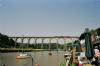
For the Tamar continue straight on past Saltash and underneath the two bridges which have adequate clearance for any yacht (see photo gallery). If planning to push on to the narrow upper reaches be aware that if the River is in spate the stream can attain rates of 5 kn on the ebb, complete with floating debris. In these cases the Lynher is probably a safer option.
Berthing, Mooring & Anchoring
The visiting yachtsman or motorboater will find numerous opportunities.....
..... for mooring or anchoring in the area covered, from Hamoaze to Calstock. Southdown Marina, Torpoint Yacht Harbour, The Mulithull Centre, and assorted boatyards in the Tamar may offer pontoons and moorings. Various clubs & pubs have moorings for thirsty passers by !
All these are now covered together with some pilotage details...
Millbrook Creek.
On the western shore shortly after passing the Mayflower Marina one will see Mashfords shipyard at Cremyll, and then the drying Millbrook Creek.(See chart) There are slipways and buildings at Southdown Marina on the northern side of the Creek. The Marina has moorings and pontoon berths that dry to soft mud. It is possible that visitors could be accommodated at £20 per night but phone ahead on 01752 823084. Facilities ashore include toilets and showers, launderette, cafe, boat lift and dry storage facilities. Freshwater and diesel are obtainable. Southdown Marina is owned by the same local company that owns Torpoint Yacht Harbour a little further up the Tamar. Link to website below:
A little further up this drying Creek is a long pontoon belonging to Multihull Centre Services Boatyard, which as the name implies specialises only in multihulls. Visiting catamarans can dry out here for two nights free of charge, after which there are charges. Facilities at this yard include showers and toilets, repairs, water, chandlery, and rigging. They can be contacted on 01752 823900, link to website below:
The village of Millbrook is walkable from either of these sites and provisions can be obtained. Fish and chips and three pubs that serve food complete the picture.
Getting back to the Hamoaze, just to the north of Millbrook Creek lies the shallow St John's lake, and then continuing northwards you come to Torpoint Yacht Harbour, just south of the chain ferries. This establishment has 80 pontoon berths and full tidal access, with 2 m depth within. Visitors can sometimes be accommodated within this walled enclosure, but it is best to arrange ahead by phoning 01752 813658. They are charging (2022) £25.00 minimum per day for visitors. Facilities include water, electricity, toilets and showers, with WiFi available. There are also 100+ moorings here with a free water taxi, sailing club & restaurant, together with lift out and dry storage facilities. Link to website below:
www.torpointyachtharbour.co.uk
Provisioning can be dealt with at Torpoint, the town centre is not far, and right next to the Marina is the Torpoint Mosquito sailing Club, where visitors are welcome.
Torpoint Mosquito Sailing Club (tmsc.org.uk)
Lynher/St. German's River
Pushing on up the Hamoaze, past the chain ferries and dockyards comes the St Germans or Lynher River on your port side to the West. There are plenty of peaceful anchorages available here, but attention is needed to 2 areas where underwater electricity cables and gas pipes cross the River. These are highlighted in red on our chart. Obviously anchoring is not allowed in these areas. The only other problem apart from large drying areas is where an overhead power cable crosses that has 30 m clearance. This is also shown on the chart. Anchor in the deeper pools to suit draft anywhere clear of moorings. Even deep draft craft can lay afloat as far up as the Dandy Hole Anchorage, which carries over 3 m at LAT ! It makes sense to carry out your explorations on a rising tide and with the aid of Admiralty chart 871.
After Dandy Hole the River dries completely, and if at anchor here a dinghy mission can be mounted to reach St Germans, where you will find the Quay Sailing Club, which has a dinghy landing pontoon and a water tap by the club. The village of St Germans about a mile away has basic provisions, a post office and a pub.
This whole area is suitable for those seeking solitude in beautiful surroundings, which may be quite welcome after a few days in Plymouth.
River Tamar
From the Hamoaze heading north, once past the entrance to the St Germans/Lynher River, St Budeaux will be seen on the eastern shore and Saltash on the western shore, together with the Tamar Bridges. Before reaching the bridges you will see the trot moorings belonging to the Saltash Sailing Club, and their short stay pontoon. This has ample water on all but low Springs. The club may be able to arrange a temporary mooring for you, call them on 01752 845988. Visitors are welcome to use the club's facilities, and it is open most lunchtimes and evenings. Link to website below:
Ashore at Saltash, the main shopping area can cope with the usual provisioning requirements and has a Sommerfield and the Co-op. Major banks with cashpoints are represented.
On the opposite bank at St Budeaux, the Tamar River Sailing Club has its waterfront premises with a landing pontoon and moorings. Telephone 01752 362741, link to website below:
www.tamarriversailingclub.co.uk
Upstream of the bridges there is pontoon off Saltash Jubilee Green, and the outer end is available for boats up to 10 m for short stays free of charge, which could be handy for provisioning in Saltash. On the eastern shore opposite, the pier is MOD property, as are the heavy moorings laying upstream of this on both sides of the River. Heading northwards past the green buoys marking the eastern bank, you will see the entrance to the River Tavy, which is blocked by a railway bridge (7.6m clearance). The River virtually dries out, but dinghies and small motorcraft can explore upstream as far as Bere Ferrers. Beware of a drying patch in the middle of the River Tamar about level with the fourth green buoy (Neal Point) which you don't want to find in the traditional manner. Stick close by the buoyage. Anchorage is possible off Neal Point on the Western side of the River, with about 0.5 m at CD (plenty of water at neaps) out of the strongest tidal flow.
Proceeding northwards an overhead power line crosses the River at Weir Point with 21 m clearance, and from here on up the River efficient use needs to be made of the tide tables and a large scale chart. Below the power line the deepwater is marked on the eastern side by a yellow buoy (indicating a water ski area) and on the Western side by a post with a red square top mark. Aim to favour the post side if trying to find the best water.
The deepwater will be evident as you approach the village of Cargreen by the trots of local moorings, although there are shallow patches. Cargreen was once a major crossing point of the Tamar River, but is now not much more than one street village running down to the Quay, a post office and general store.
Cargreen Yacht Club a little further on has a useful slipway and a tap adjacent to the clubhouse. It is usually open on Wednesday and Friday evenings through the weekend and visitors are welcome to use the facilities including the showers and the bar. If you wish to stay overnight on a club mooring there contact their moorings officer by email [email protected] (If possible 48 hours in advance) They are charging (2022) £7.00 a night to use a mooring but, unless you make prior arrangements, you will not be able to acces the club's toilets/showers etc.
Anchoring is not allowed in the vicinity of a submerged gas pipe, just north of the club and clearly marked on the charts, and slightly still further north powerlines cross the river with the clearance of 16 m.
Pushing further northwards we come to Weir Quay Boatyard, who maintain 120 moorings either side of the deeper water, and may be able to provide one for you, for around £20 a night (2022). Call them on 01822 840474. The yard has toilets, showers, diesel by Jerry can, and gas. A small provisions store and a chandlery complete the picture. Full boatyard services are available here including repairs and engineering, specialising in classic boats. Their website is:-
Continuing up the River from here things get more tricky, as apart from a few deep water pools there is less than 1 m in the deepest parts of the channel at LAT. The River winds around on itself, and the deepest water is normally found on the outside of the bends. There are few if any markings. The intrepid explorer will almost certainly find tranquil deep water pools to anchor in, but may find things get less than tranquil when large tripper boats plying between Plymouth and Calstock attempt to pass this unexpected and unwelcome obstruction in "their" narrow channel.
For the determined Gunk-holer, it is possible to push right up to and beyond Calstock, passing Cothele Quay (where there is a small maritime Museum on the Quay), and it might be possible to find an Anchorage in a deep pool just south of the Quay, with over 4 m.
The boatyard at Calstock has a full range of services available - mooring, fresh water, showers, toilets, laundrette as well as diesel, repairs and full chandlery. Boats up to 2 metres draft can be berthed by arrangement (check the charts and the tides). They are close to Weir Quay, Cotehele, Morwellham and many other places of interest, and there are train and bus services to Plymouth and Tavistock, Dartmoor and beyond. On their website they also have advice on the navigation up to Calstock which they think is not as difficult as some people make out and have accessed the boatyard with a 2 metre darft boat on the tide with ease.
www.calstockboatyard.co.uk
Visitors also have free temporary membership of Calstock Social Club. Visitors charges are £10 per night. Telephone 01822 834559
Anchorage is possible after passing under the impressive viaduct, and beyond the moorings where a deepwater pool may be found, clear of the ferry jetties. The ferry operators don't seem to mind yachts dropping off crew on their pontoon, but this is not a place to take root.
Calstock itself can boast a newsagents and food store, a couple of restaurants and pubs, a petrol station, a post office and a Lloyds Bank. There is also a station with trains to Plymouth, apart from the ferries already mentioned.
Facilities
Facilities available at the individual locations have been covered in the section above.
History
Cattewater
The city of Plymouth, Devon, England is bounded by Dartmoor to the north, the river Tamar to the west. The open expanse of water called Plymouth Sound to the south and the river Plym to the east.
The Cattewater is that stretch of water where the mouth of the river Plym merges with Plymouth Sound, just to the east of Sutton Pool. It is around this Pool that the manor of Sutton started which grew to form the present day city. On the northern shore of this confluence of waters there was a rock outcrop, which it was claimed, had the appearance of a cat. This gave its name to this stretch of water and eventually the name of Cattedown to the adjoining wharves and commercial area. Apart from an occasional small oil tanker the area is now used mostly by fishing trawlers yachts and smaller pleasure craft. There is a water taxi across it from the Mayflower Steps on Plymouth Barbican to MountBatten and also Oreston both on the southern bank.
The spelling 'Cattewater' is by not old or consistent. Local sources and texts together with early maps and drawings refer to the opning of the estuary variously as Catwater, Cat Water and Catt Water.
Saltash
Saltash (Cornish: Essa) is a town in Cornwall, England, United Kingdom. It has a population of about 17,000. It lies in the extreme southeast of Cornwall, facing Plymouth over the River Tamar. It is in the Caradon district and is known as "the gateway to Devon". Saltash means ash tree by the salt mill.
Saltash is the location of Isambard Kingdom Brunel's Royal Albert Bridge, opened by HRH Prince Albert on May 2, 1859. It takes the railway line across the River Tamar. Alongside it is the Tamar Bridge, a toll bridge carrying the A38 trunk road, which in 2001 became the first suspension bridge to be widened whilst remaining open to traffic.
Saltash railway station is close to the town centre. It was hoped that the empty buildings could be restored as a visitor centre for the bridge, but they have instead been purchased by a property developer.
The cottage of Mary Newman, Sir Francis Drake's wife, can be found in Saltash on Culver Road downhill from Saltash railway station.
There have been both real and fictitious Royal Navy ships named HMS Saltash.
Nearby are the castles at Trematon and Ince, as well as the nature reserve at Churchtown Farm.
The town expanded in the 1990s with the addition of the large new estate Latchbrook, and is currently growing further with the recent building of another housing area, Pilmere.
Saltash hosts a number of annual festivals: Saltash Mayfair takes place in and around Fore Street during early May, and Saltash Town Regatta brings music and entertainment to the Waterside area in the summer. On the water there are intense Gig races with the best teams taking part, along with Flashboat rowing and dinghy racing, and the now infamous 'England and back' race between local organisations. For 2008 a new 5 towns challenge has been added to the list of events, pitting Saltash against Liskeard, Callington, Looe and Torpoint. Ashore you will find many stalls, music and marquees.
History
There is no doubt that the history of Saltash is linked to the passage, or ferrying place across the Tamar. The original ferry became established by fisherman for those passing to and from the monastery at St. Germans and to Trematon Castle.
After the Norman Conquest, Robert, Count of Mortain, who held the castle and manor at Trematon, took the market from the canons at St. Germans and established it at Saltash. The Count granted Trematon and other manors to the de Vallerots, who had then to provide for the ferry boat. In the twelfth century a borough was founded (1190), and Saltash became the only franchised seaport between Dartmouth and Fowey. This fact has given rise to the Saltash saying, Saltash was a borough town, when Plymouth was a fuzzy down, as the City of Plymouth, and its seaport did not exist in 1190.
The Charter of Incorporation refers to the place as 'Essa' (Latin for 'Ash'). However, the spelling of the town has changed over the years. For example, in Edward the Confessor's time it was called and spelt 'Aysche'. In the 1584 Charter it is stated that Essa is now commonly called Saltash. A family called Essa lived in the twelfth century at their property near Ashtor Rock, where the Manor Courts were once held. The 'Salt' part of the name was added to distinguish it from other places called Ash.
Roger de Vallertort (Reginald De Valle Torta) sold out in 1270 to Richard, Earl of Cornwall and King of the Romans while Edward, the Black Prince, became the first Duke of Cornwall, and a visitor to Trematon Castle.
in 1549 there was a Cornish insurrection against the introduction of the Protestant liturgy, and the rebels under Humphrey Arundell, for which he was beheaded at Tyburn, gained possession of Trematon Castle by treachery, capturing Sir Richard Grenville, the elder, in the process. They then carried out acts of barbarity on their surprised visitors.
St Germans
St Germans (Cornish: Lannales) is a village in east Cornwall, England, United Kingdom. It stands on the St Germans River or Lynher River, part of the Tamar Estuary. It takes its name from the St. German's Priory Church of St Germanus. This magnificent and ancient Norman church is adjacent to the Port Eliot estate of the present Earl of St Germans.
It was originally a busy fishing village in the 19th century. The St Germans Quay was busy in the last century with cargoes of timber, coal and limestone. Until the last war the trade in roadstone continued. Now St Germans Quay is home to the village sailing club; the Quay Sailing Club (QSC). The sailing club is now well established and plays a part in the life of the village.
The village was one of the rotten boroughs, electing two members to the unreformed House of Commons until the Reform Act 1832. As in many of the Cornish rotten boroughs, the franchise in St Germans was restricted to a tiny number of "freemen", rather than to all residents, but even they were not numerous - by the time of the reform bill, the male population of the borough was only 247. However, the previous census had shown that the whole parish (of which the borough made up only a fraction) had a population of 2,404, and the initial proposal was that St Germans should lose only one of its two MPs; but the Whig government subsequently decided that the availability of sufficient population in a surrounding parish should not save a borough from disfranchisement unless a substantial part of that population was already within the borough boundaries, amending the bill's schedules so as to extinguish both of the St Germans MPs. The Tory opposition attacked the decision as politically motivated (St Germans was a Tory borough), and the vote in the Commons was one of the narrowest in the entire reform bill debates.
St Germans was originally the seat of the Bishop of Cornwall before the see was combined with Exeter in 1261. Today the Bishop of Truro's deputy is known as the Bishop of St. Germans in acknowledgement of this, although he has no specific links with the village.
St Germans railway station was opened on 4 May 1859 at the west end of St Germans viaduct, 106 feet above the quay. It is notable for having the best preserved Cornwall Railway station buildings.
Calstock
Calstock is a village and parish in south east Cornwall, England, United Kingdom, on the border with Devon. The village is situated on the River Tamar six miles south west of Tavistock and ten miles (16 km) north of Plymouth. The parish has a population of 6,095. The village is part of the Tamar Valley AONB, lies on the scenic Tamar Valley railway, and is overlooked by Cotehele house and gardens. The parish consists of 5,760 acres (23 km²) of land, 70 acres (280,000 m2) of water, and 44 acres (180,000 m2) of the tidal Tamar.
Calstock railway station opened on 2 March 1908.
The hamlets of Albaston, Chilsworthy, Gunnislake, Harrowbarrow, Latchley and Metherell are also part of the parish.
History
There is evidence of human settlement in Calstock from Roman, or pre-Roman times, settlers attracted by the rich source of minerals, such as tin, in the area. In Saxon times Calstock was in the kingdom of Dumnonia, which resisted the spread of Wessex from the east. In 838 CE Wessex had spread as far as the Tamar, and the last battle for independence was fought near Calstock. Following the Norman Conquest Calstock manor was recorded in the Domesday Book. The Saxon manor was taken over, and in the 14th century became part of the Duchy of Cornwall.
Mining was certainly important in Calstock from Mediaeval times, with the Duchy mining silver. The industry was booming in the late 19th century and the discovery of copper, and coupled with nearby granite quarrying made Calstock a busy port. The rapid population boom due to the growth of industry led, in 1849, to an outbreak of cholera. The industry declined in the early 20th century due to foreign competition, and now only the ruined pump houses that dot the landscape remain.
The Tamar is navigable to boats past Calstock some 3 miles (4.8 km) upstream to Morwellham Quay with some 10 or even 20 feet (6.1 m) of water at extreme spring tides. Calstock Quay was once important for transporting goods, and in the Victorian Era when steamers brought tourists to the village, Calstock was visited by Queen Victoria and Prince Albert in 1846. The importance of the river as a transport route declined with the construction of the 14-mile (23 km) Tamar Valley railway at the start of the 20th century. The village is still dominated by the railway's viaduct, which was first crossed by truck on 8th August 1907 and first used by passengers on 2nd March 1908.
Eating, Drinking & Entertainment
These quiet rivers and isolated anchorages are not exactly thriving with nightlife, which is perhaps the whole object of seeking out these areas. It is possible to eat out and get a pint in many of these places if one is prepared to dinghy ashore, and the facilities available at each individual spot have been covered in the berthing, mooring, and anchoring section.
Links
Other local moorings and boatyard and storage services:
www.plymouthboatliftservices.co.uk
|

Your Ratings & Comments
Choice of 2 pubs in the village, Gelato ice cream parlour, excellent woodland walking and rich mining history. Not to mention the Pirate Ship Playground. Aye!
Ashore, there's a friendly social club and a pub with good beer and friendly barmaid. No showers though, that I could find.
A few miles further up the Tamar is Morwellham Quay where copper, arsenic and other valuable minerals were loaded for transport and export in former times. It's now one of those 'living museums' with a variety of industrial attractions. I was permitted to moor for nothing on the (now grass-covered) quay itself but long lines are required, since the only mooring posts are several yards back. Good café/pub with excellent carrot cake.
Ed Note: this is, in fact, true - closed quite a while ago