You are viewing the expanded version of this Harbour,
for faster browsing
use the regular version here

Dunbar
Courtesy Flag
Flag, Red EnsignWaypoint
From the SE 56° 01.0N 002° 30.77W;Charts
From the NW 56° 01W 002° 32.34WRules & Regulations
Speed Limit 3 knotsHazards
Drying reefs scattered about the approaches to Victoria HarbourTidal Data Times & Range
HW Dunbar is HW Leith ± 5 mins MHWS 5.3m MHWN 4.1m MLWN 2.0m MLWS 0.9m (links)This site is designed for slower, roaming broadband connections, like you would get at sea, so it needs JavaScript enabled to expand the text.
General Description
Contacts
Harbour Master mob 07958 754858 or 07583 463991
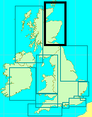
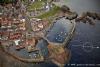
Located 30 miles East of Edinburgh and 30 miles NW of Berwick on Tweed, Dunbar is a drying harbour consists of two basins, Victoria and Cromwell, both of which are accessed via the harbour entrance through the cliffs at the West end of the Victoria basin. The old Cromwell Harbour entrance has been filled in.
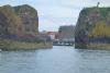
Cromwell harbour was developed by the said gentleman in the middle of the 18thC but, due to storm damage, had to be reinforced near the end of that century. There had been a small harbour here from back in the 16thC but it was very exposed so Cromwell had the East wall built and used it as a front line port to harass the Scots. Victoria Harbour was a much later addition in the middle of the 19th C and a passage, which today forms the main harbour entrance, was breached through the ruins of the old Dunbar castle. That harbour entrance is fairly narrow and I wouldn’t want to try an approach in strong onshore winds. There is a lifting bridge between the Victoria basin and the Cromwell basin but this should not be of interest to the visitor as he will be berthed in the Victoria basin.
The town itself has a long history going back into the annals of time and has variously been involved in trade, war and fishing, It’s original castle at the West end fell in to disrepair when a fort was built on the promontory between the two basins (before the Victoria basin was built). That too is now a ruin though it has been restored as a tourist attraction.
The harbour is home to a small fishing fleet which uses the South wall of the harbour whilst the rest of the harbour is given over to moorings for leisure craft. As has been said the harbour is a drying harbour; the deepest water is to be found along the South wall and on the visitors berth below the castle where you may stay afloat at neaps but will dry at springs.
The harbour website can be found at
Approach
Firstly, it would be unwise to attempt to make the harbour in strong....
.... onshore winds which would cause breaking seas across the entrance. The harbour is tidal giving about 3 hours either side of HW
You will note that we have given two Waypoints for this harbour; that is because there is a short cut between two of the islands to the North of the harbour entrance which has lead in marks/lights otherwise coming up the coast from Berwick you would have go round the outside of the islands and make your way in from the NW. The second Waypoint from the NW is for those coming down from the Forth in which case it’s just a straight run in.
From the NW it can be difficult to distinguish the harbour and your eye will be drawn to the prominent power station four miles further down the coast Coming from the NW, pass between the perches on two rocks either side of the channel (quite wide at that point)and aim for the red lead in light on the far end of the South wall. That light is not at all obvious in day time but it suffices to keep the harbour entrance open to get in.
The HM has produced a video of Dunbar and its close in approaches and this can be found HERE
Berthing, Mooring & Anchoring
If you have managed to contact the HM ....
....(He doesn’t monitor VHF at all times) he will have advised on where to berth. The visitors berth is on the starboard side as you enter the harbour marked with a blue sign saying "Visitors". It's basically a ninety degree turn to starboard and then stop; so you will need fenders rigged for starboard side to before you begin your approach to the harbour. If you have arrived at HW you will have a bit more time (and room) to enter, have a look and then make a more sedate approach.
There is a flat rate charge for all visiting boats, below 10m is £20 per night and over 10m, £25 per night
Facilities
Water is available but basically only to the South wall so if you need to do a major bunkering you would have to consult the HM for a time to move to that wall otherwise it’s a case of using your water breaker to top up. Their diesel is also on that wall so you could combine the two tasks.
There is shore power to the visitors' moorings under the castle on the inside of the entrance but not to the North wall, (though that is on the HM’s wish list) so if power is a priority you would have to get a berth just on the inside of the entrance.
Showers are available in the Yacht Club (key from either the Life Boat or the Volunteer Arms); these were not all that attractive in the summer of 2014 but, we are told, they have been tidied up somewhat since then. At the moment (June 2022) the Yacht Club is undergoing a refurb and the showers are not available.
As usual, for petrol you will have to go to the garage which is quite a distance away (they also do the Gas/Gaz there) but the HM may be able to give you a lift.
There are shops locally for small items and an ASDA way out on the outskirts of town (not within practical walking distance so a lift would be required)
Eating, Drinking & Entertainment
The Volunteer Arms is the favourite watering hole for the local yachties.
For the avid explorer there are the ruins of the fort (The Battery) at the SE end of the harbour which features on the website Dunbar Battery – A Dunbar Harbour Trust Project
Should you want a swim there is a Leisure Centre overlooking the harbour (they also have showers)
The Creel Restaurant is a recommended seafood restaurant adjacent to the harbour.
For further information on restaurants try
Restaurants & Places to Eat in Dunbar - Tripadvisor
Links
|

Got a comment to make about Dunbar ? Have you found this coverage helpful ? HAVE YOUR SAY (your email address will always be kept private)
Your Ratings & Comments
A welcoming and interesting port. Without the mishap we would not have visited as our motor yacht is not really designed for tidal quays - just pontoons!
Update by Karl Cook.
The prices have changed and we have updated the local chart