You are viewing the expanded version of this Harbour,
for faster browsing
use the regular version here

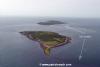
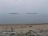
Saltee Islands
Courtesy Flag
Irish TricolourWaypoint
Kilmore Quay SWM 52° 09.22N 006°35.32WCharts
AC 2740-0 Saltee IslandsRules & Regulations
No landing on Little Saltee. See the Saltees web site (below) for rules regarding landing on Great SalteeHazards
Numerous rocks and strong tidal streams around the Saltees; AC 2740-0 can be inaccurate as regards to Latitude and Longitude. Positions derived from GPS should not be plotted on this chart.. There have been reports of “extra” uncharted rocks which have not been substantiated and may be the result of the above source datum inconsistency.Tidal Data Times & Range
HW Great Saltee is HW Cobh + 0015; MHWS 3.8m MHWN 2.8m MLWN 1.5m MLWS 0.6m The ebb and flood of the Atlantic along the South Irish Coast is disrupted around the Saltee Islands. See Approach section.This site is designed for slower, roaming broadband connections, like you would get at sea, so it needs JavaScript enabled to expand the text.
General Description
Contacts: For organised boat trips around Great Saltee contact Declan +353 (0)53 9129684
These two islands to the South of Kilmore quay belong to the Neale family who purchased the Islands in 1943 and the, then, Michael Neale declared himself “Prince Michael the First” of the Saltees. The family still own the Islands and his son, Michael, is now “Prince Michael the Second.” Prior to that the Little Saltee was the property of the Grattan-Bellews and Sir Henry returned to Little Saltee in the late twentieth century to refurbish and restock Little Saltee and has since died and his children have taken over custodianship of the Island.
The two islands are famous for their bird populations and day trips out to Great Saltee are organised at Kilmore Quay; landing is not permitted on Little Saltee and, whilst the public are welcome to visit Great Saltee, it is strongly suggested that you only do so in settled weather. Having said that, if you get caught out in strong Westerlies on passage past here, the anchorages under the cliffs of Great Saltee provide a welcome haven out of the wind.

Our chartlet of the Islands shows the various options for anchoring around the Saltees but it should be noted that the only landing place on Great Saltee is at the landing anchorage on its NW side; there is no access up the steep cliffs on the SE side. It must be said that you are unlikely to have Gilert Bay on Great Saltee to yourself on a sunny Sunday afternoon in the summer as it is probably the most popular of the available places to anchor
There is a website hosted by the owners of the Islands which provides much historical, ornithological and geological information about the islands at:-
http://www.salteeislands.info/Index.htm
Approach
Tidal Information:
To the South of Great Saltee the beginning of the
..... flood curls NE an hour before HW Cobh but as it strengthens it straightens out to follow the coast and then as it dies off towards the turn of the tide it goes round to the SE. The ebb then leads SSW at about five and a half hours after HW Cobh and, as it strengthens, it again straightens along the coast and finally as it goes towards LW it bends NW before the turn is complete and it goes back to NE for the next flood.
In Saltee Sound the streams can be up to 3.5kts at springs but the direction is unpredictable due to the many eddies.
Across St Patrick’s Bridge the flood runs through at up to 4.5kts and starts just under three hours before HW Cobh.
There is a period of about an hour slack water between ebbs and floods and vice versa.
Before you visit here it would be wise to study AC 2740-0 carefully; the area inside the 5 meter contour is scattered with rocks, named and un-named, drying, awash and submerged. Also make sure your echo sounder is working and the tanks have enough fuel for the trip as there is no fuel on the island.
You should be very careful in your use of GPS; all underwater hazards should be given a wide berth as experience has proved that positions derived from GPS systems are not compatible with the chart and can be as much as a cable out in some cases. You only have to look at the top left hand corner of AC2740 to realise how accurate the information is, based on Admiralty surveys in 1847!!!
So, “Caution” is the watch word but as long as you are reasonably careful you should have no problems and it is fun brushing up your old navigation skills; the chart shows some useful clearing sight lines and you can work out some of your own. Watch out for the rocks off the South end of great Saltee as they stretch out for about three cables from the cliffs and outside that there is that rock about half a mile off with its “ED” (Existence Doubtful) notation.
Some of the rocks have been added to AC2740 as a result of reports by various sources, specifically those three to the NNE and NE of Whitty Rock but locals have been unable to substantiate their existence which, of course, doesn’t mean they are not there somewhere; though exactly where is the problem.
Berthing, Mooring & Anchoring
The locations of the various anchorages around the islands is shown on our extract of AC2740.
Be aware that landing is permitted only on Great Saltee and that from the landing anchorage on its NW side. There is no overnight camping allowed on the island and no fires permitted. Further information can be found at the Saltee Islands website at:-
http://www.salteeislands.info/Index.htm
STAY AT LEAST 6 METRES CLEAR OF NESTING BIRDS. PEOPLE TAKING CLOSE UPS ARE SCARING THE BIRDS OFF THEIR NESTS.
Facilities
There are no facilities on the Islands.
Eating, Drinking & Entertainment
Take your own food, make your own entertainment and don’t disturb the birds.
Links
|

Your Ratings & Comments