You are viewing the expanded version of this Marina,
for faster browsing
use the regular version here


Walton Backwaters
Courtesy Flag
Flag, Red EnsignWaypoint
Pye End Buoy: 51:55'.04 N 001:17'.9 ECharts
Admiralty 2695, SC5607Rules & Regulations
8 Knts Speed LimitHazards
Much Dries Out, Unwise to enter in Strong Onshore Winds.Tidal Data Times & Range
Stone Point, Dover +0040 MHWS 4.1m, MHWN 3.3m, MLWN 1.2m, MLWS 0.5m (links)This site is designed for slower, roaming broadband connections, like you would get at sea, so it needs JavaScript enabled to expand the text.
General Description
The Walton Backwaters provides many anchoring opportunities....
with shelter available from virtually all directions. Even deep draft craft can find places to lie to their own gear. For those looking for a bit of peace and quiet the area is ideal, although the port facilities at Harwich are very visible.
The whole area, however, is more suited to shoal draft craft that can wiggle up the narrow creeks and take the ground where necessary. Owners of sailing dinghies in particular can find the Walton Backwaters a very attractive area.
"Secret Water", by Arthur Ransome is a book in the Swallows and Amazons series and is based on children's adventures afloat in these very waters.
Boating needs in the area are covered by one Marina that is available at nearly all of the tidal range, together with a yacht club and a couple of boatyards. The "pool" at Walton on Naze is well worth an overnight stop having a welcoming yacht club, full services and very attractive overnight mooring fees which have been unchanged since 2013.
It used to be the case that if planning to spend a little while exploring the creeks it was wise to do a major stock up before arriving, This is no longer the case as Walton now has an Aldi, an M&S food hall and I think it may aslo have a Tescos Express. Bedwells boatyard is also useful for bits and pieces and can haul you out if necessary.
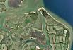
Unfortunately we do not have a good set of photos for the Backwaters yet, but the interactive Google swoop and zoom thingy has remarkable resolution in this area, to the extent of being able to recognise individual boats on pontoons or moorings. Used in conjunction with the charts it will help.
A windy day in the backwaters, but this video from Dylan Winter shows how some make good use of it !!! (It's worth noting that this looks like an offshore wind and supposedly in shelter!!)
Approach
The entrance to the Backwaters is not obvious until you are in the fairly close approaches.
It lays about a mile south of Harwich, which is very conspicuous with it's cranes and docks at Felixstow, and about 3 miles north of the conspicuous Naze Tower, a 49 m structure.
Whichever direction you approach from you will need to locate and identify red-and-white Pye End Buoy (LFl.10s)... it's coordinates are given in the data.
From the South you will be coming from the Wallet. Approaching Walton on the Naze it is necessary to maintain a good offing from the coast to avoid shallows. 1 mile minimum is recommended. The area is infested with lobster pots waiting to snag your propeller so a sharp lookout will be needed during the day, and at night it would be best to stand well offshore.
Pilotage Directions...
Keeping well off the shore and heading generally northwards you should be able to spot and identify the green conical Medusa buoy (Fl.G.5s), you can leave this close to port and set a NNW course into the Medusa Channel. NB the buoyage here is laid "flood South"
Find and identify the Stone Banks Buoy (Fl.R.5s) which can be left to starboard. This marks patches with only around 2 m at CD. From here providing the visibility is reasonable you should be able to see Harwich just to the west of North. Head towards Harwich and about a mile before you get there you should be able to find the Pye End Buoy. Alternatively enter it as a waypoint and head for it directly from the Stone Banks buoy.
From the North you will have to are cross the shipping channel leading in and out of Harwich. There is a recommended crossing points for small craft, but the main thing is to get across the Channel quickly at right angles to it. The recommended small craft track lies just to the south of the main dredged and buoyed channel and parallels it. Follow this track westwards, and at the point you would bear off to the North to enter Harwich, turn South West and locate and identify the Pye End buoy.
The approach channel to Harwich and the recommended small craft options are covered fully in the Harwich article.
Whichever way you arrive at the Pye End buoy it is now necessary to locate the buoyed channel leading into the Backwaters. This buoyage is not particularly conspicuous especially if you are arriving late afternoon and the sun is low. The shallows all around consist of hard sand and it is essential to avoid grounding in onshore winds or if there is swell.
In strong winds from the north-east or if any kind of big sea is running it is probably wiser to go to Harwich, as any kind of mistake or miscalculation could have serious consequences. You will be going across least depths of around 1 m at CD, with considerably shallower water close by on either side. Deep draught vessels may want white for a suitable rise of tide to give them a good safety margin.
From the safe water mark Pye End, a generally south westerly course will bring you to the next buoy, the red can No.2 (Fl(2)R.5s) lying about a mile away. This needs to be left to port as the water shallows to the south-east of it. Everything ahead is low-lying and you may not be able to make out the entrance yet.
Continuing on the south westerly course from this buoy locate and identify the green conical Crab Knoll (No.3) buoy (Fl.G.5s)... leave this to starboard and continue on the same track passing the unlit smaller green conical buoy No.5, also left to starboard.
A glance at the depth sounder will now show that you are in deeper water. In fact you are in a deep gully with steep hard sides... there will be no warning from the depth sounder should you stray from this channel, and the tide can run fast on the ebb.
The buoyage in this channel is laid by the Walton and Frinton Yacht Club, who get local businesses to sponsor the marks. The buoys are generally quite small but easy enough to pick out and identify with good light. In poor light conditions or at night it's difficult or impossible to make them out.
The cautious skipper will make his first entry here on a rising tide with a series of carefully planned and checked waypoints. I have ignominiously gone aground in this channel on a falling tide in a 66' MFV, while trying to depart on an ebbing tide in the first glimmers of dawn light. One mistake identifying a red buoy put us on the steep bank from which there was no escape. There we laid at an awkward angle for many hours, the subject of many comments from passing yachtsman and being suspiciously observed by a solitary seal ... cringingly embarrassing.
Having given you this warning however, in good visibility and if you take things steadily and assume nothing there should be no problems. Simply leave the unlit red buoys on your port hand side until you reach the diminutive Island Point northerly cardinal which is lit (Q).
From here you can branch off to port or carry on into Hamford Water....
Berthing, Mooring & Anchoring
Once safely within the Backwaters the visiting yachtsman or motorboater ....
...will need to decide if they're going to find somewhere to anchor or make for Titchmarsh Marina (covered shortly with prices.)
Anchoring first, even for deep draught vessels there are plenty of choices while for shoal draft vessels with explorative skippers the choices are untold.
Most first-time visitors in larger vessels looking for somewhere to anchor simply continue along Hamford Water and anchor in deepwater. The holding is generally good unless your anchor encounters weed, so it's worth digging it in under power to check.
It is worth noting that sometimes small coasters work their way to an explosives works up Oakley Creek... obviously they can only get there at HW. Once past the entrance to Oakley Creek as marked by the Easterly Cardinal buoy, you won't encounter commercial traffic.

Further explorations looking for perhaps more sheltered spots to anchor are probably best carried out when the water is fairly low but rising, so that the edges of the banks can be made out...
Landermere Creek is an option to explore. There are a few moorings as the Creek swings round to the South West around Skippers island but in general there is plenty of room to anchor. There is nowhere nearby from any of these spots to nip ashore for provisions or a pint.
Kirby Creek has oyster layings and anchorage is only possible at the very start of it, or after the layings end in the region of Honey Island, where anchorage can be had on the Western side. Anyone grounding or anchoring on shellfish beds is liable to pay damages to the owners of the damaged stock.
If anchored in this spot it is possible to make a landing on the mainland shore nearby, from where an energetic hike of well over a mile will bring you to Kirby-le Soken with shops and a couple of pubs. Alternatively a dinghy mission could be launched to follow the mainland coast around by using the gutways to arrive at Kirby Quay, where a landing can be made and you'll be on top of the village.
Not pilotage, but this video from Dylan Winter shows it can be done...
Going back to the entrance of the Backwaters, a popular daytime anchorage is off Stone Point, which is steep to with landing possible at all states of the tide. It doesn't look so promising on the chart but in actual fact there is good shelter available. There is plenty of water available, but the tide runs hard through here on the ebb and you'll have to check your anchor is well dug in. The way in to this channel is well marked by buoyage, and a little bit deeper in moorings commence and show the way.
All the mooring buoys in this area are either privately owned or belong to one of the boatyards in Foundry Reach. They are generally identified by the letters H, B, or P for private. Ones marked with an H belonged to Frank Halls & Co, while ones marked with a B belong to Bedwells. Both their details will be found in the directory, and you may be able to organise a buoy through them.
Following the Walton Channel southwards, using the moored boats as a guide to the best water you will find the main channel branches round to the West into Twizzle Creek, which is really a continuation of the Walton Channel. There is plenty of depth here but nowhere to anchor because of the moorings. This leads to Titchmarsh Marina described shortly.
Another much smaller and drying branch keeps going in a southerly direction and the branching off point is marked by a small northerly cardinal buoy called Marinestore after it's sponsor. This is the drying Foundry Creek and leads to the two boatyards already mentioned and the Walton and Frinton Yacht Club who's tireless work keeps the Backwaters buoyed. There is a very small wet basin owned by the yacht club and run by Bedwells, one of the boatyards. It can only be accessed at high water, and sometimes at neaps the gates can't be opened at all (to maintain water levels inside the basin). The basin has been modified in the last couple of years and the central mole has been removed and replaced by a pontoon and fingers. (We have supplied an aerial view of the new layout in our Navigation images) If you want a pontoon berth here for an over night stop prices haven't changed since 2013 and now (in 2022) the first night will cost you £18.00 on both pontoons and staging berths with subsequent nights at £16; Contact the Walton and Frinton Yacht Club on 01255 678161 or Bedwells on 01255 675873 . A link to the club's website is provided below:
Any kind of trip up this Creek is obviously going to need a rising tide, but perhaps the best advantage, if you can get moored up here, is the proximity to the town. If on a mooring buoy in Twizzle Creek the club and the town can be reached by a dinghy mission at most states of the tide, and landings made by the club.
Titchmarsh Marina.
The Marina has capacity for over 400 boats and is formed by a cut into the land on the southern side of Twizzle Creek. After leaving the northerly cardinal buoy Marinestore to port and turning West into Twizzle Creek you will find the way forward marked by moorings on either side of the Creek. You will then come to a pontoon on the southern side of the Creek, a gap, and then a further pontoon.
Entry to the Marina is between the pontoons, and there is around 1.3 m at LWS over the sill. Obviously deeper draft craft need a little rise of the tide. A tidal gauge on the pontoon in the approach shows the depths of water over the sill, and it may be possible to get tied up on the pontoon while waiting for enough water to enter.
Be aware that the pontoons here do not have normal cleats but closed loops through which one must pass one's warps, so, unless you have one of those clever thingies on the end of boat hook for picking up buoys, you'll have to send someone ashore to tie up. And, if you are single handed, best of luck, 'cos it's you skipper!! Joking apart, it might be an idea to call the marina on the box (#80)and get them to send someone down to take your lines. (Still the case in 2022!)
Contact the Marina on VHF channel 80 or callsign Titchmarsh Marina. Alternatively telephone 01255 672185. A link to the Marina's website is provided below:
http://www.titchmarshmarina.co.uk/
All the normal Marina facilities are available including water and electricity (£1 per night for 7.5Kw card) on the pontoons, toilets and showers ashore, and WiFi available. A 10m overnight berth is £22 for 2022.
Diesel is available at the fuel berth while Calor and Camping Gaz are both available. A scrubbing berth is available while a 35 tonne travel lift and 25 tonne crane can handle most boats. All boatyard services are available, and there is a well-stocked Chandlers on-site.
The Harbour Lights pub/restaurant is on-site and available for the hungry and thirsty crew, but for a bigger choice a journey will have to be made to the town.
Provisioning is not straightforward or easy as it either involves a long hike to Walton or a taxi ride.
If not going to the Marina there is little of interest once past the pontoons in Twizzle Creek. Oyster beds occupy the rest so there is nowhere to anchor.
Taking the ground.
Shoal draft boats able to take the ground will find many places suitable throughout the whole area. A good survey beforehand would make sense so you don't end up sitting on anything unpleasant or on the edge of a deep gutway. The shellfish beds are shown on the charts...... avoid.
Updated March 2022
Facilities
Initially it appears that there is nothing much in the way of facilities really and services available at the Marina have already been mentioned.
The boatyards in Foundry Reach may be able to help with problems, as may the Marina boatyard. The moorings in the basin at Walton have shore power (card) and water whilst the club has free Wifi
Most day-to-day town facilities will be found at Walton, it's a popular little holiday spot, so provisioning won't be a problem . Gas Gaz and fuel is available at Titmarsh Marina.
Trailer Sailers looking to launch will find a slipway at Titchmarsh Marina that is usable all the tidal range at a cost of £18. PWC's are not allowed.
Any kind of transport for crew changes etc. Will have to be handled through Walton which has a railway station connecting with Colchester and London. There is also a National Express coach service to London.
History
Walton-on-the-Naze is a small town in Essex, England, on the North Sea coast in the Tendring district. It is north of Clacton and south of the port of Harwich. It abuts Frinton-on-Sea to the south, and is part of the parish of Frinton and Walton. It is a resort town, with a permanent population of about 12,000. It attracts many visitors, the Naze being the main attraction. There is also a pier.
Walton has an HM Coastguard team and houses Thames MRCC (Maritime Rescue Coordination Centre), organising rescues from Southwold to Herne Bay.
Walton-on-the-Naze railway station is on a branch of the Sunshine Coast Line.
The Naze
"Naze" derives from Old English næss "ness, promontory, headland". In 1722 Daniel Defoe mentions the town calling it "Walton; under the Nase".
The Naze is a peninsula north of the town. It is important for migrating birds and has a small nature reserve. The marshes of Hamford Water behind the town are also of ornithological interest, with wintering ducks and brent geese. Many Bird watchers visit at migration times.
The Hanoverian tower (more commonly known as the Naze Tower) at the start of the open area of the Naze was a sea mark to assist ships on this otherwise fairly featureless coast.
The Naze is eroding rapidly and threatening the tower and the wildlife. The Naze Protection Society was formed to campaign for erosion controls. The Naze has become popular for school fieldwork into erosion and methods to protect the coast. Protection includes a sea wall, a riprap, groynes and a permeable groyne as well as drainage. Millions of tons of sand have been added to the beach to replenish it and stop the cliff eroding. However, the cliff near Naze Tower is greatly eroded. The cliff is receding fast and within 50 years Naze Tower may have tumbled into the sea like the pill boxes that can be seen on the beach.
Walton Pier
The original pier was built in 1830, one of the earliest in the country. It was built for landing goods and passengers from steamers and was 300ft (91m) long. The pier was badly damaged in a storm in the 1890s. In 1895, the Walton-on-the-Naze hotel and pier company (then owners of the pier) opened a replacement pier 500ft longer than the original. Several extensions have increased the pier's length to 2,600ft (793m), the third longest in the UK.
When the new pier opened in 1895, an electric tramway was installed to take passengers from the steamers to the front of the pier. This was in use until 1935 when it was upgraded to a battery-powered carriage. In 1945 fire damaged the pier, and the carriage was replaced by a diesel locomotive train. This was removed during the 1970s.
Today, the pier remains a popular attraction, with amusements and fun-fair rides in a hangar-type building. Beyond this, the pier extends into a promenade popular with anglers.
War memorial
The unusual war memorial commemorates a Halifax crew which all died when they crashed on the Naze. It also has a tribute to Herbert George Columbine ,who won the VC and after whom the local leisure centre is named, and a tribute to those lost in World War I in HMS Conquest.
Cultural references
Walton was inspiration for the fictional Balford-le-Nez in Elizabeth George's "Deception on His Mind." Hamford Water and the town of Walton-on-the-Naze are the location of Arthur Ransome's Swallows and Amazons book, Secret Water.
The text on this HISTORY page is covered by the following licence
http://en.wikipedia.org/wiki/Wikipedia:Text_of_the_GNU_Free_Documentation_License
Eating, Drinking & Entertainment
This whole area is not really the place for a boisterous night out.... unless your idea of a wild night out is sharing a peaceful anchorage with wild birds and seals!
If at the Marina you have the choice of the on-site offering or a long trip to town. If on a mooring buoy or at anchor providing the tide serves a trip can be made up the drying Foundry Reach to reach the Walton and Frinton Yacht Club who are welcoming to visiting yachtsman. If you do tie up in the Walton Basin the village has plenty of shops, eateries and several interesting looking pubs
From this area an exploration can be made of the little holiday town where you will find ample pubs and restaurants to suit most tastes, but unfortunately one eye will have to be kept on the tide tables for your return dinghy trip. A couple of links are provided below exploring what's available in Walton.
Pubs:
http://www.beerintheevening.com/pubs/results.shtml/el/Walton%20on%20the%20Naze%3BEssex/
Restaurants:
Restaurants & Places to Eat in Walton-on-the-Naze - Tripadvisor
Links
|

Your Ratings & Comments
The center mole has gone and been replaced with pontoons with electricity.
Access is still via the 'Cat Flap' around high water so all boats stay afloat at all states of the tide.
For more details and to book the cat flap go to:- https://walton-on-the-naze.cylex-uk.co.uk/company/bedwell==-co-13036060.html
If you wish you can also moor on trots, with direct access to ashore in the mud outside.
The Walton Basin has been updated, for info and access go to:- https://marinas.com/view/marina/x1crv6_Bedwell_and_Company_Boatyard_Walton_on_the_Naze_GB_United_Kingdom
Regards
Capt Nik"
Regards
Pete"
The pontoons do not have open cleats, but closed loops that lines have to be looped through. Take care when coming alongside and get someone ashore quickly to hold your boat as you cannot simply lasoo a cleat.