 Grimsby (Marina and Docks)
At a Glance
Download Guide
"We have waded in mire for five terrible weeks; there was no
lack of mud where we were, in the middle of Grimsby. But now away
we let our ship resound meerily on the waves over the sea to
Bergen."
This was written in verse by the Viking Rognvald Kali.
Well there is still no lack of mud in Grimsby, but over the many intervening years docks have been built, first to serve fishing fleets and nowadays also housing a Marina. This facility belongs to the Humber Cruising Association, and they do cater for visiting small craft. The marina surrounds are not very pituresque but verything you need is available.
Grimsby is within easy reach of the mouth of the Humber although the visiting Mariner will still have to plan his times carefully to fit in with the powerful tides.
Once installed in the Marina the visitor will find himself within striking distance of all the considerable town facilities. Grimsby has turned itself into a major shopping centre for the area, therefore there will be no lack of things to do and see.
Liftings and repairs can be handled.
Transport connections for crew changes etc. are good. Couple this with the fact that if heading south to the East Coast this will be your last chance for a really decent stock up until Lowestoft. Likewise if cruising northwards from the East Coast you will probably be in need of a decent stock up before pushing on. Unlike our hapless Viking of the poem you won't be having "wade in mire" to stash your booty onboard....
Grimsby (Marina and Docks)
Approach
Any kind of approach to the River Humber needs a good study of the charts,.....
..... to understand the various well buoyed shipping lanes in the approaches. The yachtsman or motorboater, even at low water, can keep out of and skirt the edges of these lanes. Approaching from the South it is easy enough to keep well clear of them, and indeed if going to Grimsby there is no need to get involved at all. There are clearly marked recommende tracks on the UKHO but, although there are dashed lines on the Navionics charts they don't identify them.
One point worth noting if approaching from the South is to be aware of the Tetney Monobuoy (53º 32'.36N 000º 06'.75E). This is used by large tankers, and when not in use has a floating pipeline that can extend 290 m from the buoy. The pipeline is marked by quick flashing yellow lights, and the buoy itself is lit 2 VQ.Y(Vert). Small craft should give it a very wide berth.
You should also be aware of the Off shore Wind Farms from both the North and South. You can come down the coast from Flamborough inside the Westermost Rough site and the Humber Gateway site but the wind farms off Skegness will cause you some head scratching if coming up from Wells whilst, from the Wash you can plan inshore of them.
On top of all this there is the Donna Nook Firing Range (Air to Ground) Active 0900 to 1630 weekdays only during the summer. They operate on a "clear range" policy (ie they can't operate if there is any shipping in the range) They listen out on #16. It's up to you if you want to cut the cornerover over the Rosse Spit - it saves about 2 miles, otherwise you have to skirt round the DZNo3 buoy.
Pilotage details:
Approaching from the North, providing you keep
well clear of the Outer Binks that radiates eastwards from Spurn
Head, you should be able to pick up and parallel the edge of the
shipping channel as defined by the Spurn easterly Cardinal light
float, the South East Chequer southerly Cardinal light float, and
the Chequer southerly Cardinal buoy. The shallows of the Outer
Binks Sands can produce very rough seas that are best avoided by
small craft altogether.
There can be tidal eddies in the region of The Chequer buoy, also to the north of the shipping channel between Chequer Sand and Spurn Head. These tidal eddies can be dangerous for small craft. It is however assumed the skipper has done his tidal calculations and is approaching Spurn Head either at slack water or with the tide under him.
The tidal flow around Spurn Head is slack at around high water Hull, but then commences its outpouring immediately... reaching a maximum of over 4.3 kn three hours after high water Hull (at spring tides, neaps 2.5 kn maximum). Six hours after high water Hull there is still a significant outflow in this immediate region, up to 1.8 kn.
At six hours before high water Hull the tidal flows are slack around Spurn Head, but by three hours before high water Hull they can increase to inflow of 3.8 kn at Springs and 1.7 kn at neaps.
It would therefore be a complete waste of time trying to force your way in against the powerful ebbing tide, furthermore you would be exposing yourself to unpredictable tidal eddies too. Six hours before high water Hull to high water Hull is the window for pushing your way in here. Bear in mind the Marina lock gates only open for free flow between one and two hours before local high water, depending on the height of the tide, and you need to time your arrival off Grimsby to coincide with this.
Shipping permitting there is nothing to prevent you encroaching into the channel a little if you have to... at least you're going the right direction. It does need to be noted however that sometimes large deep draught ships have to use the wrong side of the Channel between Spurn Head and the Spurn Light Float.
At some point a skipper is going to have to take the bit in his teeth and plunge across the Traffic Separation Scheme and ABP Humber recommend that this should be done in the region of Chequer SCM, avoiding the currents close to Spurn Head, as shown in the website reference below
Alternatively having mastered the currents around Spurn Head (and clear of the TSS) the small craft Mariner could look for his opportunity to cross the shipping channels after passing close to Spurn Head, preferably at right angles and get himself into the Bull Channel.
A north-westerly course can then be set from the region of the Bull sand Fort, and the following buoyage could be paralleled to keep you out of the way of ships. First the red can Bull Sand buoy (Q.R) is left to starboard, then the red light float No.4A Clee Ness(Fl(2)R.10s) is also left to starboard. A more westerly course is set and the red can No 4B buoy (Fl.R.2s) is also left to starboard. From No.4 B, WNW should get you to Lower Burcom red light (No.6) Float (Fl.R.4s). Here you will be in deep water and able to see the entrance to the docks. You may be perturbed by the shallow soundings in this area but even at LWS there's over a metre of water and, as you will be near the top of the tide, there will be plenty of water
The directions given above are specifically to keep you out of channels used by ships, you will be passing the red buoyage the "wrong way", and out of the channel. Bear in mind not to wander off too far to port.
It would be extremely wise to monitor VTS Humber on VHF Channel: 14 and 16 for traffic movements, and change to VHF channel 12 once past the Clee Ness (4A) light float. A link is given below to the page on the official Humber websites that deals with advice and regulations for small craft, this should be studied: Be in no doubt that this is as busy a piece of water as anywhere in the UK; you will need to keep a careful radio watch as well as a 360 degree visual scan for oncoming and overtaking vessels. And for goodness sake remember that if you can't see the bridge windows he can't see you.
http://www.humber.com/Yachting_and_Leisure/Pleasure_Craft_Navigation/
They also give their own pilotage directions for pleasure craft entering and using the Humber.
£ GMT
Waypoint
Charts
Rules & Regs
Hazards
Tides
Berthing
The previous paragraphs gave guidance on how to approach the docks at Grimsby.....
.....this piece is more concerned with getting into Humber Cruising Association's Marina...full details and visitors prices:
As already mentioned it is necessary to be lurking off the entrance at the times that the fish dock is open for free flow. This might not always be so easy as although the tides are not so strong as elsewhere in the Humber they can easily reach 3 kn at springs. Call VHF channel 74 for the "Fish Dock Island", and find out the times of free flow. There's free access to the open lock two hours either side of high water, outside of these times leisure vessels can lock through for a £20 charge.
There is absolutely nowhere convenient to wait or anchor nearby. Waiting in the Outer Harbour is possible but not topside friendly...
In northerly winds if you have to wait, anchorage is available off Hawkins Point on the North side of the River tucked well in. Anchorage is also available off Spurn Head, but neither of these would be too clever in brisk southerlies.
Perhaps the best plan is to arrange that your vessel arrives in Grimsby Road not much earlier than two hours before high water, and no later than one hour after high water. If you do have to gill around for a while it won't be for long.
The stranger here may be tempted by the huge lock gates to the West of the tall brick red hydraulic tower into the main harbour. You want the smaller lock to the East of the tower into the Fish Docks
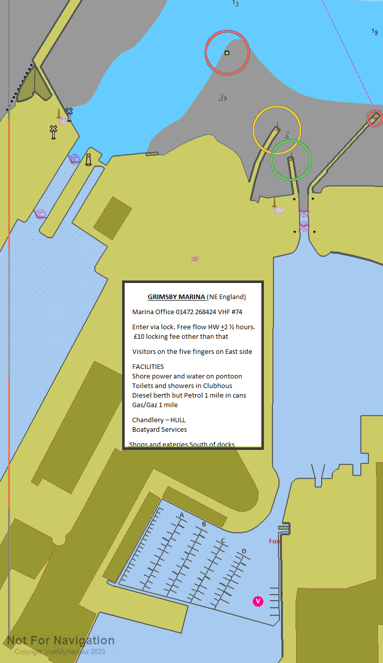
Once through the lock don't wander off to port, proceed straight to the number two fish dock, . Here you will find the Humber Cruising Association's Marina, with visitors moorings on the East Quay, show clearly on the Chart.
You can contact the club on 01472 268424 for the Marina or VHF Channel 74. A link to their website is provided below:
Prices (2022) work out at 2.45 per metre per day dropping to £11.15 per metre for a week and further reductions for longer stays. This is a minor increase on previous years but their old price had been maintained for years before this. This includes shore power with a minimum charge of £17.15
Updated March 2022
Marinas and Mooring
Grimsby Port Authority
Port Office, The Quay, Cleethorpe Road, Grimsby, DN31 3LL
The HCA Fishing Club
The Croft, North End Crescent, Tetney, Lincs, DN36 5LZ
Humber Cruising Association Ltd
Meridian Quay, Fishing Docks, Aukland Road, Grimsby, NE Lincs. DN31 3RP
Facilities
The usual facilities are available with water, electricity (included with the mooring fee) and toilets and showers ashore. Laundry facilities are available.
A travel lift together with hardstanding are available for visitors, and diesel fuel is available too.
The visitor won't have to go too far to find bottled gas (Calor Shop on Hainton avenue does Camping Gaz as well as Calor) and other chandlery. All kinds of engineering and repairs can be accomplished in the area. Check the directory.
Grimsby as already mentioned is a major shopping centre for the area, and to get to the centre of the action which is not exactly on top of the docks, it is possible to nip one-stop on the train. Grimsby Dock has it's own railway station, with Cleethorpes in one direction and Grimsby Town in the other. Trains every couple of hours after 0900 and the last one back about 2255
There are a Tescos and an ASDA fairly close but you'll need your shopping trolley. Update 2022 There is now an ALDI on Cleethorpes Road (unfortunately that is on the other side of the Railway line so it's about a twenty minute walk.
The award-winning Freshney Place Shopping Centre in the heart of the town boasts over 70 stores including Marks and Spencer, Binns (House of Fraser) and BHS. All the usual banks complete with cash machines will be found.
TransPennine Express provide direct trains to Manchester Airport via Doncaster and Sheffield whilst Northern Rail operate services to Barton-upon-Humber (for buses to Hull) and Lincoln and East Midlands Trains services to Nottingham.
14 miles west of Grimsby is Humberside Airport, which mainly caters for charter holidays. There are also scheduled flights to Aberdeen and Amsterdam, provided by Eastern Airways and KLM respectively.
Boatyards & Boatyard Services
Chandlers
Spinnaker Yacht Chandlery
Plot 5 Europa Way, Grimsby, South Humberside, DN41 8DS
TG Marine Chandlery
8 Oakfield Close, Springfield Park, Scartho, Grimsby, DN33 3ALE
What to Do
The Marina boasts a friendly clubhouse on the spot, and as mentioned the town is not exactly on top of the moorings.
Should you venture to town you'll find there is no shortage of places to eat, drink or enjoy some nightlife. The history section has some notes on this, and the links provided below will give the inquisitive a place to start:
Pubs:
grimsby pubs and bars; pubs in grimsby # beerintheevening.com
Restaurants:
History
Grimsby (or archaically Great Grimsby) is a seaport on the Humber Estuary in Lincolnshire, England. It has been the administrative centre of the unitary authority area of North East Lincolnshire since 1996. According to legend, Grimsby was first founded by Grim, a Danish fisherman. 'By' means 'village' in Old Norse and 'city' or 'town' in the modern Danish language. The town was previously titled "Great Grimsby" to distinguish it from Little Grimsby, a village about 14 miles (22 km) to the south, near Louth. People from Grimsby are called Grimbarians.
The town itself has a population of around 87,589. It is physically linked to the adjoining town of Cleethorpes, and 11,000 of its inhabitants live in the village of Scartho which was absorbed into Grimsby before laws on the Green Belt were put in place. All three areas come under the jurisdiction of the same council, North East Lincolnshire. It is close to the main terminus of the A180, which ends in Cleethorpes. 22 January is Great Grimsby Day.
History
Vikings
Grimsby was founded by the Danes in the 9th century AD, although there is some evidence of a small town of Roman workers sited in the area some seven centuries earlier. Located on The Haven, which flowed into the Humber, Grimsby would have provided an ideal location for ships to shelter from approaching storms. It was also well situated for the rich fishing grounds in the North Sea.
The name Grimsby probably originated from the Grim's by, or "Grim's Village". This is based on Grim the Danish Viking, supposedly the founder of the town, with the suffix -by being the Old Norse word for village. For more on the legendary founding of Grimsby see the Lay of Havelock the Dane. This is only one explanation of the founding of Grimsby, and is completely unsupported, being a legend. There is however a Grim and Havelock Association which has produced evidence to back up the legend.
In Norse Mythology, 'Grim' (Mask) and 'Grimnir' (Masked One) are names adopted by the deity Odin (Anglo-Saxon 'Woden') when traveling incognito amongst mortals, as in the short poem known as 'Grimnir's Sayings' (Grimnismal) in the Poetic Edda , so the intended audience of the Havelock tale (recorded much later in the form of The Lay of Havelock the Dane) may have implicitly understood the fisherman Grim to be Odin in disguise. The Odinic name 'Grimr/Grim' occurs in many English placenames within the historical Danelaw and elsewhere in Britain, examples being the numerous earthworks named Grimsdyke [3]. Every other British placename containing the element Grim- is explained as a reference to Woden/Odin (e.g. Grimsbury, Grimspound, Grime's Graves, Grimsditch, Grimsworne), so one may argue that 'Grimsby' is unlikely to have a different derivation.
Grimsby is listed in the Domesday Book, having a population of around 200, a priest, a mill and a ferry (probably to take people across the Humber, to Hull.
It also appears in the Orkneyinga Saga in this Dróttkvætt stanza by the Viking Rognvald Kali:
Vér hofum vaðnar leirur vikur fimm
megingrimmar;
saurs vara vant, er várum, viðr,
í Grímsbœ miðjum.
Nú'r þat's más
of mýrar meginkátliga
látum
branda elg á bylgjur Bjorgynjar til dynja.
"We have waded in mire for five terrible weeks; there was no lack of mud where we were, in the middle of Grimsby. But now away we let our beaked elk [= ship] resound meerily on the waves over the seagull's swamp [= sea] to Bergen."
During the 12th century, Grimsby developed into a fishing and trading port, at one point ranking twelfth in importance to the Crown in terms of tax revenue. The town was granted its charter by King John in 1201 The first mayor was installed in 1218.
Grimsby does not have town walls. It was too small and was protected by the marshy land around it. However, the town did have a ditch. In medieval times, Grimsby had two parish churches, St Mary's and St James'. Only St James' now remains.
In the 15th century, The Haven began to silt up, preventing ships in the Humber from docking. As a result, Grimsby entered a long period of decline which lasted until the late 18th century. In 1801 , the population of Grimsby numbered 1,524, around the same size that it had been in the Middle Ages.
Fishing and maritime industry
In the early 19th century, the town grew rapidly. The Great
Grimsby Haven Company was formed by Act of Parliament in May 1796
(the Grimsby Haven Act) for the purpose of "widening, deepening,
enlarging, altering and improving the Haven of the Town and Port of
Great Grimsby". Grimsby's port boomed, importing iron,
timber, wheat, hemp and flax. New docks were necessary to cope with
the expansion. The Grimsby Docks Act of 1845 allowed the necessary
building works.
Alexandra Docks and National Fishing Heritage Museum
The Dock Tower was completed in 1851, followed by The Royal Dock in 1852. No.1 Fish Dock was completed in 1856, followed by No.2 Fish Dock in 1877. Alexandra Dock and Union Dock followed in 1879. During this period the fishing fleet was greatly expanded.
The arrival of the railway in 1848 made it far easier to transport goods to and from the port. Coal mined in the South Yorkshire coal fields was brought by rail and exported through Grimsby. The population of Grimsby grew from 75,000 in 1901 to 92,000 by 1931 but then remained fairly static for the rest of the 20th century.
The former Humber ferry, PS Lincoln Castle, is moored in Alexandra Dock. It used to be a pub\restaurant, but now lies adjacent to Corporation Bridge, its future very much uncertain. Also in the dock is the Ross Tiger, a trawler which can be toured in the summer as part of the Fishing Heritage centre.
World War II
During World War II, Grimsby's status as a major port made it a focus of the German Luftwaffe. They used the Dock Tower as a landmark and refused to bomb it (the British Government discussed its' demolition to prevent its use as a navigational aid). It was later revealed that had the German invasion been successful Grimsby would have been one of the first landing points in the north of England due to the combination of its location and its infrastructure. This was probably one reason why the town suffered significantly less bombing raids than neighbouring fishing port Hull whose geographical location would have made it harder to reach. However, Grimsby was still hit by numerous air raids during the war and 197 people were killed. Grimsby was also the first place in Great Britain to have the Butterfly Bomb used against it by the Luftwaffe in 1943, devastating many areas.
The Royal Dock was used as the UK's largest base for minesweepers, to patrol the North Sea. Minesweepers are military vessels using deep-sea trawling methods. There is a memorial next to the dock.
In reference to modern-day minesweeping, HMS Grimsby is a Sandown class minehunter (commissioned in 1999) currently in service in the Royal Navy.
Economy and manufacturing
Frozen food
Grimsby is indelibly linked with the sea fishing industry, which once gave the town much of its wealth. At its peak in the 1950s, it was the largest and busiest fishing port in the world. However as a result of the Cod Wars with Iceland this industry has been in decline for many years. It is still home to the largest fish market in the UK although most of what is sold is now brought overland from other ports or Iceland via containerisation.
In recent years the frozen food industry has become a large part of Grimsby's economy and new industries such as light engineering, chemicals and plastics have grown. Grimsby held the record at one time for the largest 'Cold Store' in the UK and it was in Grimsby that the UK's first 'fish finger' food was produced in 1955. Birds Eye closed their frozen ready meal factory in 2005, ending a link with the town that stretched back 50 years. The said factory has since been demolished, following a fire which gutted the building and almost totally destroyed it itself. Arson is suspected. 70% of the fish sold at the town's market is now imported from outside the United Kingdom, particularly Iceland.
Grimsby is colloquially known as UK Food Town, previously known as Europe's Food Town. It is said that more pizzas are produced in Grimsby than anywhere else.
The food production and seafood heritage links are perpetuated in a UK 2006 Young's Seafood television advertising campaign emphasising Grimsby as the source of its seafood products. In the campaign, Grimsby Docks are briefly shown, at dusk, lit and shot somewhat romantically. In 2008 this was followed up by further commercials paying reference to the town and its main industry as the company launched a range of Great Grimsby fish-based frozen meals.
Shopping facilities
The award-winning Freshney Place Shopping Centre in the heart of the town boasts over 70 stores including Marks and Spencer, Binns (House of Fraser) and BHS. It was originally constructed between 1967 and 1971 in a joint venture between the old Grimsby Borough Council and developers Hammerson's UK Ltd. and was known as the Riverhead Centre (so named as the development was adjacent to where the two local rivers, the Freshney and the Haven, meet). Victoria Street is the main shopping street.
The Riverhead Centre development caused some controversy at the time as it followed the 1960s trend of replacing old architecture with new; in this case it involved the wholesale demolition of much of the old town centre including the historic Bull Ring (which is now where Wilkinson's, the Halifax Bank and the St James Hotel are based) and streets going back many centuries including Flottergate, Brewery Street and East St Mary's Gate.
In 1990 the council agreed to sell the area around the shopping centre, used for surface car parking, to Hammerson's UK Ltd.. The development owner and Humberside County Council, the highway authority at that time, agreed to the sale of the area of Baxtergate, the road which ran to the rear of the shopping centre, between the shopping centre and the surface car park. Baxtergate was relocated alongside the River Freshney and became phase one of the Peaks Parkway. Hammerson's UK Ltd. began a £100 million redevelopment of the site which saw it double in size. The centre was also covered in a glass roof and (where the new extension was built) two multi-storey car parks were constructed at each end of the centre, effectively privatising, roofing and enclosing the old Top Town area of Grimsby. Servicing to the stores was made available from a first floor service area, accessible by even large vehicles, using a ramp at the western end. The ramp also provided access to the car park on the roof of the indoor market which is operated by the local council. In recognition of the design of the new facilities, the Royal Town Planning Institute awarded the scheme a commendation in 1992.
Other developments near the town centre include a new Tesco Extra (the second in the area), the Victoria Mills Retail Park which is home to several chain stores including Next and a B&Q Depot off the Peaks Parkway A16.
Unlike many other towns who have shopping facilities on their outskirts, these (and other similar developments) can be found in and around Grimsby's town centre, making shopping far easier for pedestrians and public transport users, reflecting Grimsby's relatively cheap central commercial land. Other major retailers include the supermarket chains Tesco, Marks & Spencers, Sainsbury's, Asda on Holles Street and Morrison's. The Morrison's store is located just outside the town boundary, in the parish of Laceby, and is peculiarly known as Morrison's Cleethorpes. This is an anomaly arising from when the area was part of the now defunct Cleethorpes Borough. Most major supermarket's in the town have expanded somewhat in the last few years, including a massive extension built at Asda, and more recently another floor was built at Tesco at Hewitts Circus. Trade is going from strength to strength.
There are also a number of local, independent specialist stores and the Abbeygate Centre (off Bethlehem Street) is where many are located. Abbeygate Centre has been dubbed "Little Town" by locals. Once the head office of local brewers Hewitt Brothers it was renovated in the mid-1980s and is home to a number of restaurants and designer clothing stores. The town also has two markets, one next to Freshney Place and the other in Freeman Street (B1213), itself once a dominant shopping area in the town with close connections to the docks but one that has sadly struggled since the late 1970s when the fishing industry declined.
In March 2007, Henry Boot properties announced a new £30m shopping development adjacent to the existing Freshney Place site. The project will create 150,000 square feet (14,000 m2) of retail space and 290 car parking places on land between the River Freshney and Sainsbury's, presently occupied by the former Travis Perkins builders' merchants. Included in the plans are 25 residential apartments with the possibility of riverside Nightclubs and amusement Arcades.
A new retail and leisure complex is also to be built on the West Marsh by landowners P&O Estates. Covering 85 acres (340,000 m2) and costing £35 million it is planned to be open by 2009, although there is little evidence of construction work as of March 2008; a smaller retail development is planned alongside the proposed new stadium for Grimsby Town FC at Great Coates adjacent to the A180, scheduled for completion in mid-2010. A road access to the area has been built from a new roundabout on Cromwell Road, near to the town's Leisure Centre, with a bridge, over the main railway line to the town, leading to the former refuse land fill site. There is a retail park next to Alexandra Dock.
Such is the quality of shopping in the area that bus services are run to bring in shoppers from across the county of Lincolnshire, especially from smaller towns such as Louth, Brigg, Market Rasen and Scunthorpe.
Entertainment
The area has a developed, if somewhat corporate, nightlife. Aside from the nightclubs in nearby Cleethorpes, the town centre has undergone a renaissance in the last decade. A number of national pub chains have redeveloped or opened new outlets, including a specially-built complex at the Riverhead which is home to three (originally five) such operations. Prior to the late 1960s many public houses in the area were owned by the local brewer Hewitt Brothers and gave a distinctive local touch but following a takeover in 1969 by the brewer Bass Charrington these have been re-badged (many times), closed or sold off; examples are the Yarborough Hotel.
Musical entertainment is found at the Grimsby Auditorium, built in 1995, on Cromwell Road in Yarborough near Grimsby Leisure Centre. The smaller Caxton Theatre is on Cleethorpe Road (A180) in East Marsh near the docks. The Caxton Theatre provides entertainment by adults and youths in theatre. A notable theatre company in the area is the Class Act Theatre Company run by local playwright David Wrightam. The company produces strong factual drama and premiere award-winning productions.
North East Lincolnshire Council have installed a Wi-Fi network covering Victoria Street in central Grimsby. The service provides access to the Internet for the general public on a yearly subscription.
Transport
Buses
Grimsby's bus service is provided by Stagecoach which took over the original Grimsby-Cleethorpes Transport in 1993. Grimsby-Cleethorpes Transport had been formed in 1957, with the merger of the previously separate Grimsby and Cleethorpes transport (GCT) undertakings. Stagecoach had all the buses resprayed to their standard livery to replace the buses previous colour-scheme of orange and white. Prior to this, the buses were painted blue and white until 1981, when the colours were changed to caramel and cream. The orange and white livery was introduced in 1987. Until 1982 GCT ran a mixture of crewed and one-person operated services. However, in that year the job of conductor was abolished and the company changed entirely to driver-only services.
In 2005, Stagecoach bought out Lincolnshire Road Car, who provided buses to Killingholme, Louth, Barton-upon-Humber and the Willows Estate. The company is now known as Stagecoach in Lincolnshire. Joint ticketing was allowed with Stagecoach Grimsby-Cleethorpes from May 2006.
From September 2006, a new fleet of low-floor single-decker was introduced, making the fleet an unprecedented 85% low-floor.
Railways
Grimsby also has rail links via Grimsby Town railway station and Grimsby Docks railway station. There is a level crossing in the centre of the town across Wellowgate. TransPennine Express provide direct trains to Manchester Airport via Doncaster and Sheffield whilst Northern Rail operate services to Barton-upon-Humber (for buses to Hull) and Lincoln and East Midlands Trains services to Nottingham. The service to Cleethorpes runs at least hourly during the day, along a single track, passing stations at Grimsby Docks and New Clee.
Airport
14 miles (23 km) west of Grimsby is Humberside Airport, which mainly caters for charter holidays, and is popular for general aviation, with five flying clubs based there. There are also scheduled flights to Aberdeen and Amsterdam, provided by Eastern Airways and KLM respectively.
The text on this HISTORY page is covered by the following
licence
http://en.wikipedia.org/wiki/Wikipedia:Text_of_the_GNU_Free_Documentation_License
Local Business
Boat Charters
Marine Engineering
Blackrow Engineering Co Ltd
Estate Road 7, South Humberside Industrial Estate, Grimsby, South Humberside, DN31 2TP
Bacon Marine Engineering
Hutton Road Fish Docks, North East Lincolnshire, Grimsby, South Humberside, DN31 3PS
Rigging and Riggers
Grimsby Yacht Rigging Ltd (2)
Humber Bank South, Fishdocks, Grimsby, DN31 3SD