 Isle of Man-Douglas
At a Glance
Download Guide
Contacts
Marine Operations Centre VHF 12 tel no 01624 686628
Inner Harbour Office tel no 01624
687543
Douglas Bay Yacht Club tel no 01624
673965
Douglas Harbour is situated at the South end of sweeping Douglas
Bay. Douglas itself is the capital of the Isle of Man and has been
a very popular holiday resort since Victorian times. Approaching
from the sea you could be coming into Weymouth, Bridlington or any
of a number of similar Victorian seaside towns; broad sandy beach
backed by a wide promenade and behind that tall nineteenth century
houses which have been converted into apartments, hotels, B&Bs
and interspersed with amusement arcades and souvenir shops; it's
all here, risqué postcards, Isle of Man rock, T-shirts
and fish and chips!! (For amusements and diversions see our section
on Entertainment below)
As well as being a holiday resort, by reason of its independent
status, the Isle of Man is well known as a tax haven for the well
heeled, has a very busy financial district in the middle of the
town and the island is "home" to quite a few well known people. On
top of this, situated in the middle of the Irish Sea with sea
connections to England, Ireland and Scotland the island has an
amazing mix of dialects during the summer as young men & women
from all these areas flock here for work; you'll be amazed at the
number of Irish accents you come across.
When you visit here you have definitely left "England" and only
fifty years ago if you misbehaved on a run ashore you could expect
to be sentenced to a birching (the last birching was carried out in
1975). You will also be aware of the TT races, held on closed roads
at the end of May and early June. The course follows the A1 Peel
Road out to the A3 which it follows all the way round to Ramsey; it
then returns to Douglas via the A18 and A2. These roads are closed
for most of the time so travel in those areas is much restricted
although you can still get to Ramsey via Laxey on the A2. The
south of the island is undisturbed by the races themselves but
basically the whole island is taken over by the circus and
spectators involved in this world famous event, accommodation is
full, campsites are full, pubs and restaurants are full and so will
be the marinas and harbours. Unless you are following the races it
would not be a good time to come here for a quiet cruise.
The harbour itself is the main entry port to the Isle of Man and is
the terminus for HS ferries, slower freight vessels and car/lorry
transporters and you in your 28 foot pride and joy will have to
dodge through the lot to get to your mooring. The harbour consists
of an outer basin protected by Battery Pier; the ferries dock
between Victoria Pier and King Edward VIII Pier and yachts proceed
between King Edward VIII pier and Fort Anne Jetty through a drying
basin, over a flap gate into the yacht basin.
There is an IOM harbour information website which lists all the IOM
harbours and a whole raft of downloadable docs (most of which do
not apply to cruising skippers) at:-
Isle of Man Government - Harbours
Information
Isle of Man-Douglas
Approach
The tidal streams close in around the IOM do
not follow those depicted in the UKHO tidal Atlas; there are often
counter currents. For close-in information you can access the
IOM's own tidal streams info at
tidal_streams.pdf
(gov.im)
tidal_streams_2.pdf (gov.im)
We suggest that if you are spending any time in
the Irish sea with regular visits to the IOM you visit those two
internet pages, print and add them to your Pilot Book.
What eve r direction you are coming from it is imperative that you contact Marine Operations Centre on Channel 12;
They will be able to advise you of any, large fast traffic. It
might also be an idea to contact the Inner Harbour Office before
departing for here to see what sort of room is available in the
Inner Harbour. They don't take reservations but at least you'd know
if there was no chance at all!!
When positioning for the approach give the end of Battery Pier a
wide berth and make your final run in to the Initial Fix from the
NE to avoid any possible overfalls off the end of that pier. If
making your approach at night note that the lead in lights (to the
right of the Lifeboat house) are Blue. It won't have passed your
notice that there is a large lump of rock topped by a tower just NW
of the harbour entrance; at HW you need to give that tower at least
a cable and a half offing to avoid the rubbish around it. If you've
studied your history you will know that the tower was built not to
warn of the rock but as a refuge for distressed mariners who could
not make it back into harbour; you can actually land here in a
dinghy at LW if you want to explore it.
As you approach the harbour entrance you should take notice of the
International Port Signals at the end of Victoria Pier which we
have reproduced in the picture gallery. (If you have an old copy of
the Imray Pilot for these waters the subsidiary lights mentioned in
that publication no longer exist)
**You can only get right in to the pontoons in the inner harbour
two hours either side of HW, outside these times and during the
summer months only, there is a temporary berth available on a
pontoon alongside berth 14 (see chartlet)**
https://www.gov.im/categories/travel-traffic-and-motoring/harbours/douglas/
Once you have negotiated the harbour entrance, continue on course for the lead in marks/lights until the channel between the King Edward VIII pier and Fort Anne Jetty opens up and make for that. Note that the lights on the end of these piers are two verticals and that there is another set of vertical reds at the inner end of Fort Anne Jetty. Then it's just a case of motoring up to the lifting bridge/flapgate keeping well to starboard especially if near the time limits for this approach. The inner harbour office listens on Channel 12 so should be aware of your approach and will advise you of the next opening time (roughly every half hour unless you happen to arrive at rush hour)
£ GMT
Waypoint
Charts
Rules & Regs
Hazards
Tides
Berthing
The main berths are in the inner harbour but,
......... as has been mentioned, there are berths available on the pontoon by no 14 berth on the Battery Pier. A NE wind sets up an uncomfortable swell inside the harbour so this pontoon is not a good place in those conditions.
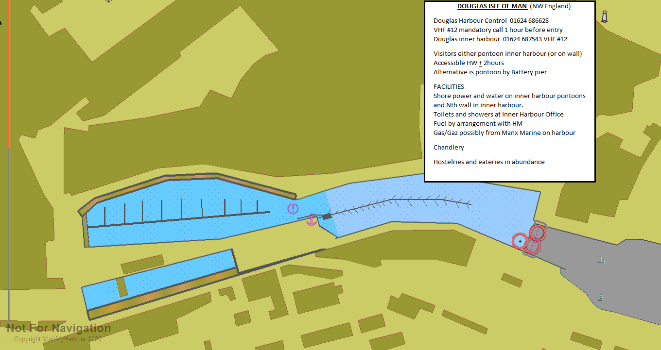
Within the inner harbour there are pontoon berths or alongside berths against the wall.
You can anchor out in the bay but that's more for very large boats with mile of cable and a mechanical winch! If you anchor in close you'll be liable to get caught up in the surf at some stage of the tide.
In 2022 if you tie up for the night in the outer harbour in a 10m boat you will be charged £16.68, against the wall in the inner harbour it's £25.00 and for a pontoon it's £34.32 (that does entitle you to free shore power)
The harbour authorities have advised that the reports of silting in the inner harbour have been addressed and that, as all visitors have to check in with them before gaining entry to the Inner Harbour, they are able to allocate a berth suitable to the vessels draft.
Facilities
Water and power (payment card) is supplied on the pontoons in the inner harbour, but just water on the outer harbour pontoon. There's a shower and toilet block next to the Inner Harbour Office at the west end of the Tongue where you'll also find the Douglas Bay Yacht Club. The Yacht Club is RYA affiliated and also houses showers, toilets and a two bars. Their web site has links to all the services available on the Island including chandlers, sailmakers, electrical and electronic engineers, mechanical engineers and boatyards; they also do food on race days and Sundays.
http://www.douglasbayyachtclub.com/
We have been advised that the chandler, Manx Marine, has ceased
operations which has made the obtaining of fuel cards difficult.
These cards are still available at Peel from the Manx Fish
Producers but, until they sort something else out you will have to
rely on voluntarty help to obtain red diesel or treck across to
Peel. (Thank you our member Jaypea below)
Chandlers
Manx Marine
The Tongue Building, The Tongue, Douglas Harbour, Douglas, Isle of Man. IM1 5A
What to Do
You are spoiled for choice here and we will not attempt to list
all the watering holes and eateries; just explore and enjoy.
For entertainment they have three theatres and two cinema, eight
night clubs. On a Saturday night the area close to the marina and
the South end of the promenade is the focal point for the younger
generation; for family meals/entertainment you'd best try the
Gaiety Theatre, Villa Marina or Summerland Concert venue further
along the promenade.
For days out there is the Electric Railway to the Laxey Wheel, the
Steam railway to Peel and if you walk to the far end of the prom
you can always hop on a horse drawn tram to rest tired feet on the
way back.
Bus & train time tables https://www.gov.im/categories/travel-traffic-and-motoring/bus-and-rail
Ideas http://www.isleofman.com/
Yacht Clubs and Associations
History
Local Business
Marine Electrics/Electronics
Outboard Sales and Service
MJS Mobile Marine Services
Balthane Industrial Estate, Ballasalla, Isle of Man. IM9 2AL
Bottom Line Ltd Unit 8
Side Road, Middle River Industrial Estate, Douglas, Isle of Man. IM2 1AL