You are viewing the expanded version of this Harbour,
for faster browsing
use the regular version here

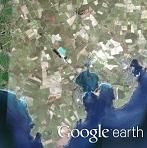
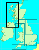
Killough Bay
Courtesy Flag
Flag, Red EnsignWaypoint
None GivenCharts
AC 0633, Ardglass & Killough Harbours, AC 0044 Nose of Howth to Ballyquintin, SC 5612-3 Ardglass & Killough Harbours, Imray C62 Irish SeaRules & Regulations
NoneHazards
Water Rocks at the entrance to the bay; further rocks to left and right of the approach transit. Shoals and rocks out to 2 cables from both Ringfad and Ringsallagh Points.Tidal Data Times & Range
HW is Dover +0025. + 0020 on Belfast. MHWS 5.3m MHWN 4.6m there is no data for LW but Ardglass is MLWN 1.7m MLWS 0.7mThis site is designed for slower, roaming broadband connections, like you would get at sea, so it needs JavaScript enabled to expand the text.
General Description
Killough harbour in the bay adjacent to Ardglass was first built in.....
..... the 18th Century by Michael Ward who, a man after our own hearts, objected to paying the harbour dues at Strangford!! He owned a mansion called Castle Ward near Strangford and the street in Killough called “Castle Street” still runs all the way to that mansion. Mind you it is a ten mile long road!!
The harbour became a busy place exporting grain for the wars between England and France in the late 18th Century and expanded to support that trade in the early 19th Century. The impressive houses on Castle Street were built by the, then, wealthy corn merchants but when the Napoleonic War ended the bottom dropped out of that market and Killough slowly declined.
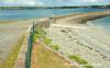
Ardglass took over as the main port on that bit of coast and took the fishing trade with it. The village fell into decline and until the late 20th Century the piers at Killough and Coney Island opposite it also became derelict. The pier on the Killough side was restored earlier this century to encourage local fishing; the result is a sturdy pier with no facilities.
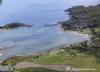
The bay offers an anchorage which is sheltered in off shore conditions but anything from the East through to the SSW causes a scend in the bay that, in some conditions, reaches behind the pier. The pier dries at LW so only of use for vessels which can take the ground; the range here is relatively high (about 3m at Neaps) so the pier is accessible after half tide depending on your draft. The harbour is unmanned with no facilities and no ladders.
Killough Bay has been declared an ASSI which covers the shoreline down to the Mean LW line. The pier itself has a security fence at its root preventing acces to or from the pier so it is presumed that you should not tie up here. On the other hand anchoring (but not drying out) is ok.
Approach
From the South although there is water between the Water Rocks.....
..... and Ringsallagh Head it’s best to leave the Water Rocks to port and come in on the transit (304T) between the castellated building at the shore end of Killough Pier and Castle Bright up on the hill beyond the village.
Once abeam Crane Point to starboard, if there is sufficient water, you can turn towards the end of the pier and clew up on the northern side of the pier; the southern side is sloped an not tenable as an alongside berth.
If anchoring, a spot with suitable depth can be found between Crane Point and the ruin at the south end of the village but it might be a good idea to moor to two anchors to limit your scope. If the wind is in the east it would be better to anchor in Coney Island Bay but pick your spot carefully and again consider two anchors.
Facilities
You’ll find nothing on the pier in the way of water or shore power. We suspect that the pier itself is guarded by a security fence with a locked gate.
There is a Mace shop on Castle Street which has fuel and Gas (possibly Gaz as well) along with basic provisions.
If more than that is needed then you’ll have to go to Ardglass. (There is a bus about every hour after 9am but the last bus back is just before 7pm). Mind you; the bus fare is probably less than the Ardglass harbour dues so why not?
Eating, Drinking & Entertainment
There are two or three pubs one of which has a restaurant attached, one fish and chip shop and that’s about it!
Links
Shipping Forecast
http://www.metoffice.gov.uk/weather/marine/shipping_forecast.html#All%7EIrishSea
Inshore Forecast
Lough Foyle to Carlingford Lough
http://www.metoffice.gov.uk/weather/marine/inshore_forecast.html#LoughFoyletoCarlingfordLough
|

Got a comment to make about Killough Bay? Have you found this coverage helpful ? HAVE YOUR SAY (your email address will always be kept private)
Your Ratings & Comments