

Harbour Information (use the  icons to find out more)

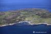

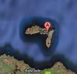
Rathlin Island and Rathlin Sound
Your Comments: 9 Read or add your comments
Courtesy Flag
Flag, Red EnsignWaypoint
None GivenCharts
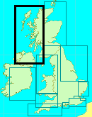
AC 2798-0 (Lough Foyle to Scanda Island), SC 5612 (Carlingford Lough to Loch Foyle), Imray C64 (North Channel)Rules & Regulations
None KnownHazards
Strong currents, eddies, overfalls and a named whirlpool. (Slough-na-more)Tidal Data Times & Range
Rathlin Harbour (Church Cove). High Water is HW Dover -0445 at Springs but -0200 at Neaps. Rathlin Sound Turns Easterly at HW Dover ?-5Hrs. Turns Westerly at HW Dover + 1Hr.___ EXPAND "More Info" for full explanation and tidal flow diagrams.This site is designed for slower, roaming broadband connections, like you would get at sea, so it needs JavaScript enabled to expand the text.
General Description
Contacts: HM Ballycastle VHF Channel 80. Tel No 02820768525. Mob 07803505084 ... read more
Approach
Expand the "More Information" section for detailed tidal information. ... read more
Berthing, Mooring & Anchoring
There are now three pontoons in Church Bay with about 2 m depth. ... read more
Your Ratings & Comments
9 comments
UPDATE AUGUST 2022
Written by Don Thomson 3 | 19th Aug 2022
I reviewed these notes in August 2022. They are now charging by the metre here otherwise no changes. They are still worried about their futures here due to a dwindling population.
UPDATE SUMMER 2021
Written by Don Thomson 3 | 15th Jul 2021
I reviewed these notes in July 2021. As far as we can tell the Primary School is still a going concern so the local population is probably also stable. The facilities are quite good though if you arrive short of supplies you might have to take a trip across to Ballycastle to stock (as do the locals!)
1 of 1 people found this helpful
Update Summer 2019
Written by Don Thomson 3 | 1st Jul 2019
These notes were reviewed in July 2019. The price here has increased to £22.50 per night but the rest remains the same.
Great little place - for adults and children
Written by MW | 21st May 2017
We arrived on a calm and sunny day. Pontoon provides water and electricity and it is included in the fee (£21.50). A great place to watch the seals just across from the boat and listen to birds. The birds centre at the west lighthouse is worth a visit ( take a bus...). Beach in the bay is great for children, play park too. Showers are ok, but need to be pressed every 5seconds for the water to keep coming. The pub does lovely fish and chips! Definitely a place to visit.
1 of 1 people found this helpful
UPDATE APRIL 2017
Written by Don Thomson | 18th Apr 2017
I reviewed these notes in April 2017. The facilities here have improved over the years with more pontoons and facilities for yachties ashore.
1 of 1 people found this helpful
Guinness to die for.
Written by Barbados Billy | 25th Sep 2016
We crossed from Port Ellen on Islay but couldn't lay the west side of Rathlin. We made the east side but had a battle with the Macdonnell race and foul tide to get round Rue Point and into Church bay, half expecting to end up miles down the coast. There are additions to the pontoons now with two long fingers (fully serviced) parallel to the south pier. Piling and a works barge in the north west corner of the harbour, adjacent to the north breakwater means that anchoring is not advisable as it impedes the ferry turning. We had a super time on Rathlin. The bar was even better and if you are that way inclined it can't be missed.
1 of 1 people found this helpful
Update 2015
Written by dononshytalk | 7th Apr 2015
These notes were reviewed by Don in April 2015. There are some extra pontoons inside the harbour at Rathlin Island. I have added to the notes on the tidal streams to emphasize the effect that was noticed by Cullin on his trip here in 2014. The counter current he came across then runs from Dover +1 to Dover +3
1 of 1 people found this helpful
Very Strong South-going Current from Church Bay to Rue Point
Written by cuillin | 9th Apr 2014
We have found a very strong south-running current from Church Bay to Rue Point on the early flood tide. Have met this current on the (6 hour or so) passage from Belfast Lough, taking the north-going ebb. We found that we had to move well out from the coast into the bay, to make any progress to Church Bay. Advice is not to try to follow the coastline!
1 of 1 people found this helpful
Charming island & worth a visit
Written by Miura | 21st Mar 2012
I have an aunt who lives here so I visit regularly. I like the island and find it peaceful & relaxing. The harbour is well sheltered and there is a decent pontoon for yachts. Yachts normally tie up on the West side but don't go too far in if you draw over 1.7m.There is enough water to tie up on the East side of the pontoon but I would advise reversing back out when leaving. It gets shallow rapidly about 10-15 metres east of the pontoon and you risk grounding if you try to go forward & turn in a fin keeler. We have had several meals in the Manor House Hotel and all have been acceptable.There is also a pub nearby. There are decent walks & lots of bird life. HMS Drake, torpedoed and then run aground in Rathlin Bay in 1917 is apparently no longer a hazard to surface navigation. However, I still stay clear. It is marked with a Cardinal buoy.
3 of 3 people found this helpful

© visitMyHarbour.com | website design created by Black Culm Ltd