Admiralty Standard Chart
Admiralty Standard Charts:

For nautical charts covering the coastlines of the UK and Ireland the source of nearly all information is the United Kingdom Hydrographic Office (UKHO) and the custodianship organisations (such as Port and Harbour authorities) who work with them. All other UK leisure charts are based on information licensed directly from the UKHO.
The UKHO produces an series of over 3,300 Standard Nautical Charts which meet the requirements of professional, commercial and recreational navigation in accordance with SOLAS regulations, ensuring safe navigation at sea worldwide.
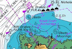
A quick glance at the familiar " mustard and cobalt" Admiralty charts will show depths, coastal features, and hazards of interest to the mariner.The fine detail available on the larger scale charts is unrivalled and is coupled with the Admiralty's renowned accuracy. Tidal stream data in tabulated form is generally included in the chart together with notes on the composition of the seabed (which will help with anchoring decisions, but probably stems from the days when the "lead" was armed with tallow, enabling a seabed sample to be brought up and help in the confirmations of position).
Admiralty Standard Nautical Charts are produced in a range of scales for safe ocean navigation covering passage planning, harbours and nautical hazards, anchorages, coastal and offshore navigation. They are printed on heavy cartridge paper, and sold by Admiralty chart agents fully updated.
Admiralty Notices to Mariners, weekly editions, contain information which enables the mariner to keep his charts and books published by UKHO up-to-date for the latest reports received. New editions and new charts are listed in advance in Weekly Notices to Mariners in booklet format and via the UKHO website.
These standard Admiralty charts (together with the backup systems used to update them) are in day-to-day use by serious professional mariners worldwide, including the Royal Navy.
Standard Nautical Charts retail at £21.35 each.
Exactly the same charts are available electronically via the ARCS service, which allows the use of familiar charts within electronic navigation systems. For leisure sailors "Charts for SeaClear and Marine Navigator" use the same official charts in electronic format.
Over 400 Standard Admiralty Charts give complete coverage of the UK and Ireland, divided into 8 Folios. They are listed below.
Folio 1, South coast of England:
18 FALMOUTH INNER HARBOUR
26 HARBOURS ON STH COAST OF DEVON
28 SALCOMBE HARBOUR 47/00
30 PLYMOUTH SOUND & APPROACHES
31 HARBOURS ON SOUTH COAST OF CORNWALL
32 FALMOUTH HARBOUR 09/02
34 ISLES OF SCILLY 26/01
147 PLANS SOUTH COAST CORNWALL
148 DODMAN POINT TO LOOE BAY
154 APPROACHES TO FALMOUTH
442 LIZARD POINT TO BERRY HEAD
536 BEACHY HD TO DUNGENESS
777 LAND'S END TO FALMOUTH
871 RIVERS TAMAR,LYNHER & TAVY
883 ISLE OF SCILLY. ST MARYS
1148 ISLES OF SCILLY TO LANDS END
1178 APPROACH TO BRISTOL CHANNEL
1267 FALMOUTH TO PLYMOUTH
1610 APPROACHES TO THAMES ESTUARY
1613 EDDYSTONE TO BERRY HEAD
1634 SALCOMBE TO BRIXHAM
1652 SELSEY BILL TO BEACHY HEAD
1698 DOVER 13/05
1827 HARBOURS SE COAST ENGLAND
1900 WHITSAND BAY TO YEALM HD
1901 SMEATON PASS & THE NARROWS
1902 PLYMOUTH, HAMOAZE
1967 PLYMOUTH SOUND & RIVER PLYM
1991 HARBOURS OB S CST ENGLAND
2021 HBRS & ANCH. WEST SOLENT AREA
2022 HBRS & ANCH EAST SOLENT
2035 WEST APPROACHES TO SOLENT
2036 SOLENT & SOUTHAMPTON WATE
2037 EAST APPROACHES TO SOLENT
2038 SOUTHAMPTON WATER & APPROACHES
2041 PORT OF SOUTHAMPTON 39/05
2044 SHOREHAM HARBOUR & APP
2045 OUTER APPROACH TO SOLENT
2154 NEWHAVEN HARBOUR
2172
2175 POOLE BAY
2253 DARTMOUTH HARBOUR
2255 APP PORTLAND & WEYMOUTH
2268 PORTLAND HARBOUR
2290 RIVER EXE & APPROACHES
2345 PLANS IN SOUTH WEST CORNWALL
2450 ANVIL POINT TO BEACHY HEAD
2451 NEWHAVEN TO DOVER
2454 START POINT TO THE NEEDLES
2610 BILL OF PORTLAND TO ANVIL
2611 POOLE HARBOUR & APPROACHES
2615 BILL OF PORTLAND TO THE
2625 APPROACH TO PORTSMOUTH
2628 PORTSMOUTH HBR, N PART
2629 PORTSMOUTH HARBOUR, S PART
2631 PORTSMOUTH HARBOUR
2675 ENGLISH CHANNEL
2793 COWES HARBOUR & RIVER MEDINA
3315 BERRY HD TO PORTLAND BILL
3418 LANGSTONE & CHICHESTER HARB'S
CHANNEL ISLANDS
60 ALDERNEY & CASQUETS 20/04
807 GUERNSEY AND HERM 20/04
808 EAST GUERNSEY, HERM, SARK
1136 JERSEY NORTH COAST 20/04
1137 APPROACHES TO ST HELIER
1138 JERSEY EAST COAST 20/04
2845 ALDERNEY HARBOUR 20/04
3140 ST PETER PORT 20/04
3278 SAINT HELIER 20/04
3654 GUERNSEY, HERM & SARK
Folio 2, Bristol channel and south coast of Ireland
1076 LINNEY HD TO OXWICH PT
1123 WEST APPS ST GEORGES CHANNEL
1149 PENDEEN TO TREVOSE HEAD
1152
1156 TREVOSE HD TO HARTLAND PT
1160 PLANS ON COAST SOMERSET
1161 SWANSEA BAY, RIVER NEATH
1164 HARTLAND POINT TO ILFRACOMBE
1165 WORMS HEAD TO WATCHET
1166 AVONMOUTH TO SHARPNESS
1167 BURRY INLET
1168 HBRS ON N COAST CORNWALL
1169 APPROACH TO PORTHCAWL
1176 STEEPHOLM TO AVONMOUTH
1179 BRISTOL CHANNEL 48/04
1182 BARRY & CARDIFF ROADS
1447 DUBLIN & DUN LAOGHAIRE
1478 ST GOVANS TO ST DAVIDS
1765 OLD HEAD OF KINSALE TO POWER
1773 PORT OF CORK, UPPER HARBR
1777 PORT OF CORK, LOWER HARBR
1838 SHOT HEAD TO BANTRY
1840 BLACK BALL H TO SHOT HEAD
1859 PORT OF BRISTOL
2046 WATERFORD HARBOUR
2049 KINSALE TO TUSKAR ROCK
2053 KINSALE HARBOUR & OYSTER HVN
2071 YOUGHAL
2081 COURTMACSHERRY BAY
2092 TOE HEAD TO KINSALE
2129 LONG IS BAY TO CASTLEHAVEN
2184 MIZEN HD TO GASCANANE SD
2423 MIZEN HEAD TO DINGLE BAY
2424 KENMARE RIVER TO CORK HBR
2552 DUNMANUS BAY
2740 SALTEE ISLANDS
2878 APPROACH TO MILFORD HAVEN
3273 ENTRANCE TO MILFORD HAVEN
3274 ST ANNS HEAD TO NEWTON NOYES
3275 MILFORD DOCKS TO PICTON POINT
Folio 3, Irish sea, Firth of Clyde and north coast of Ireland
44 NOSE OF HOWTH TO BALLYQUINTIN PT
633 PLANS ON EAST COAST OF IRELAND
1121 IRISH SEA, ST GEORGES CHANNEL
1237 LARNE LOUGH & APPROACHES
1320 FLEETWOOD TO DOUGLAS
1344 KIRKCUDBRIGHT BAY
1346 SOLWAY FIRTH & APPROACH
1403 LOCH RYAN 22/03
1410 SAINT GEORGES CHANNEL
1411 IRISH SEA, WESTERN PART
1413 APPROACHES TO HOLYHEAD
1415 DUBLIN BAY
1463 CONWY BAY & APPROACHES
1464 MENAI STRAIT 40/04
1468 ARKLOW TO SKERRIES ISLAND
1482 PLANS ON S&W COAST DYFED
1484 PLANS IN CARDIGAN BAY
1512 PLANS ON LLEYN PENINSULA
1552 PORTS IN MORECAMBE BAY
1752 APPROACHES TO BELFAST
1753 BELFAST LOUGH & APPROACH
1772 ROSSLARE & WEXFORD HRBRS
1787 CARNSORE PT TO WICKLOW HD
1826 IRISH SEA, EASTERN PART
1864 HARBOURS IN ARRAN & KINTYRE
1866 PORTS IN FIRTH OF CLYDE
1867 HUNTERSTON CHANNEL & ROTHESAY
1906 KYLES OF BUTE
1907 LITTLE CUMBRAE IS TO CLOCH PT
1951 APPROACHES TO LIVERPOOL
1953 APPROACHES TOTHE RIVER DEE
1970 CAERNARFON BAY
1971 CARDIGAN BAY, NORTH PART
1973 CARDIGAN BAY, SOUTH PART
1977 HOLYHEAD TO GREAT ORMES
1978 GREAT ORMES HEAD TO LIVERPOOL
1981 APPROACHES TO PRESTON
1994 APPROACHES TO RIVER CLYDE
2000 GARELOCH & RHU NARROWS
2007 RIVER CLYDE
2010 MORECAMBE BAY & APPROACHES
2011 HOLYHEAD HARBOUR 34/05
2013 ST BEES HEAD TO SILLOTH
2093 S APPROACHES TO NORTH CHANNEL
2094 KIRKCUDBRIGHT TO MULL OF GALL.
2126 APP TO FIRTH OF CLYDE
2131 FIRTH OF CLYDE & LOCH FYN
2156 STRANGFORD LOUGH
2159 STRANGFORD NARROWS
2163 LOUGH NEAGH 40/04
2198 NORTH CHANNEL, SOUTH PART
2199 NORTH CHANNEL NORTH PART
2220 PLADDA TO INCHMARNOCK, S SHEET
2221 PLADDA TO INCHMARNOCK
2381 LOWER LOCH FYNE
2382 UPPER LOCH FYNE
2383 INCHMARNOCK WATER
2491 ARDROSSAN TO LARGS 37/03
2494 PLANS ON N COAST IRELAND
2510 APPROACHES TO LONDONDERRY
2511 APPROACHES TO LOUGH FOYLE
2696 PLANS IN ISLE OF MAN
2697 LOUGH SWILLY 10/05
2699 HORN HEAD TO FANAD HEAD WITH
2723 WEST APP TO NORTH CHANNEL
2724 NORTH CHANNELTO FIRTH OF LORN
2752 BLOODY F'LAND TO HORN HD
2798 LOUGH FOYLE TO SANDA ISLAND
2800 CARLINGFORD LOUGH 42/04
2811 SHEEPHAVEN TO LOUGH FOYLE
3164 BARROW HARBOUR & APPROACHES
3478 MANCHESTER SHIP CANAL
3490 PORT OF LIVERPOOL 40/04
3746 LOCH LONG & LOCH GOIL
Folio 4, West coast of Ireland
1125 WEST APPROACH TO IRELAND
1540 SHANNON AIRPORT TO LIMERICK
1547 KILCREDAUN PT TO ARDMORE
1548 ARDMORE PT TO RINEALON PT
1549 RINEALON TO SHANNON AIRPORT
1819 APPROACHES TO RIVER SHANNON
1820 ARAN IS TO ROONAH HEAD
1879 RATHLIN O'BIRN TO ARAN IS
1883 CROHY HD TO BLOODY F'LAND
1904 GALWAY HARBOUR & APPROACH
1984 GALWAY BAY
2057 WESTPORT BAY & APPROACHES
2096 CASHLA BAY TO KILKIERAN BAY
2125 VALENTIA ISLAND
2173 LOOP HEAD TO SLYNE HEAD
2254 VALENTIA TO RIVER SHANNON
2420 ARAN IS TO BROAD HAVEN
2495 KENMARE RIVER
2667 CLEW BAY & APPROACHES
2702 DONEGAL BAY
2703 BROADHAVEN BAY & APPROACH
2704 BLACKSOD BAY & APPROACHES
2706 BALLYNAKILL & KILLARY HBR
2707 KINGSTOWN TO CLEGGAN BAY
2708 B'CONNEELY TO CLIFDEN BAY
2709 ROUNDSTONE & APPROACHES
2715 KILLALA & DONEGAL
2725 BLACKSOD BAY TO TORY ISL
2767 PORTURLIN TO SLIGO BAY
2789 DINGLE BAY & SMERWICK HBR
2790 VENTRY & DINGLE HARBOURS
2792 PLANS ON NW COAST IRELAND
2852 SLIGO HARBOUR & APPROACH
3338 KILKEE TO INISHEER
3339 APPROACHES TO GALWAY BAY
Folio 5, West coast of Scotland
1127 OUTER APPROACH TO NORTH CH.
1128 BANKS WEST OF THE HEBRIDES
1757 THE LITTLE MINCH, NORTH PART
1778 STANTON BANKS TO PASSAGE TIREE
1790 OBAN & APPROACHES 11/05
1791 CALEDONIAN CANAL 43/05
1794 NORTH MINCH,SOUTHERN PART
1795 THE LITTLE MINCH, SOUTH PART
1796 BARRA HEAD TO ARDNAMURCHAN
2168 APPROACHES TO SOUND OF JURA
2169 APP TO FIRTH OF LORN
2171 SOUND OF MULL & APPROACH
2207 ARDNAMURCHAN TO SLEAT SOUND
2208 MALLAIG TO CANNA HARBOUR
2209 INNER SOUND 16/03
2210 APPROACHES TO INNER SOUND
2326 LOCH CRINAN TO FIRTH OF LORN
2343 GULF OF CORRYVRECKAN
2372 CORRAN NARROWS 15/04
2379 LOCH LINNHE,CENTRAL PART
2386 FIRTH OF LORN, SOUTHERN PART
2387 FIRTH OF LORN, NORTHERN PART
2388 LOCH ETIVE & APPROACHES
2389 LOCH LINNHE, SOUTHERN PART
2390 SOUND OF MULL & LOCHALINE
2392 SOUND OF MULL - WEST ENTRANCE
2394 LOCH SUNART
2396 SOUND OF JURA, SOUTH PART
2397 SOUND OF JURA, NORTH PART
2474 HARBORS IN THE INNER HEBRIDES
2475 SOUND OF GIGHA
2476 LOCHS & HARBOURS IN SND JURA
2479 INNER SOUND,NORTHERN PART
2480 INNER SOUND CENTRAL PART
2481 SOUND OF ISLAY
2498 INNER SOUND SOUTHERN PART
2500 APPROACHES TO ULLAPOOL
2501 SUMMER ISLES
2509 RUBHA REIDH TO CAILLEACH
2528 LOCH GAIRLOCH, KISHORN &
2529 APPROACHES TO STORNOWAY
2533 ANCHS ON WEST COAST SKYE
2534 PLANS IN SOUND OF RAASAY
2540 LOCH ALSH & APPROACHES
2541 LOCHS ON W COAST SCOTLAND
2617 SOUND OF IONA
2635 SCOTLAND, WEST COAST
2652 LOCHS NA KEAL & TUATH
2722 SKERRYVORE TO SAINT KILDA
2769 BARRA HEAD TO GREIAN HEAD
2770 SOUND OF BARRA
2771 LOCH SCRIDAIN
2802 SOUND OF HARRIS
2825 LOCHS ON EAST COAST UIST
2841 LOCH MADDY TO LOCH RESORT
2904 USINISH TO EIG MHOR
2905 EAST LOCH TARBET
3146 LOCH EWE
Folio 6, North and east coasts of Scotland etc.
2 BRITISH ISLES
35 SCAPA FLOW & APPROACHES
115 MORAY FIRTH 52/04
190 MONTROSE TO FIFE NESS INC.
210 NEWBURGH TO MONTROSE 44/02
213 FRASERBURGH TO NEWBURGH
219 W APPROACH TO ORKNEY & SHETLAND
222 BUCKIE TO FRASERBURGH
223 DUNROBIN POINT TO BUCKIE
1077 APP TO CROMARTY FIRTH
1078 INVERNESS FIRTH
1119 FAIR ISLE CHANNEL 41/05
1129 BANKS NW OF HEBRIDES
1233 N APPROACH TO SHETLAND IS
1234 NW APPROACH TO ORKNEY IS
1239 ORKNEY & SHETLAND ISLAND
1407 MONTROSE TO BERWICK UPON TWEED
1409 BUCKIE TO ARBROATH 32/04
1438 HARBOURS ON EAST SCOTLAND
1446 ABERDEEN HARBOUR
1462 HBRS N & E CST SCOTLAND
1481 RIVER TAY DUNDEE DOCKS
1553 BAY OF KIRKWALL 37/03
1785 NORTH MINCH,NORTHERN PART
1889 CROMARTY BANK TO INVERGORDAN
1890 INVERGORDON TO DINGWALL
1942 FAIR ISLE TO WICK 51/05
1954 C WRATH TO PENTLAND FIRTH
2076 LOCH ERIBOLL 06/05
2162 PENTLAND FIRTH & APPROACH
2249 ORKNEY ISLANDS WEST SHEET
2250 ORKNEY ISLANDS EAST SHEET
2502 EDDRACHILLIS BAY
2503 APPROACH TO KINLOCHBERVIE
2504 APPROACH TO LOCHINVER
2524 ISLANDS OFF NW SCOTLAND
2562 PLANS IN NORTH ORKNEY ISLANDS
2568 HARBOURS IN THE ORKNEY ISLANDS
2581 SOUTH APPROACH TO SCAPA FLOW
2584 APPROACHES TO KIRKWALL
2720 FLANNAN IS TO SULE SKERRY
2721 SAINT KILDA TO BUTT OF LEWIS
3271 LERWICK HARBOUR & APPROACHES
3272 MOUL OF ESWICK TO HELLIWICK
3281 SHETLAND IS - NW SHEET
3282 SHETLAND IS - NE SHEET
3283 SHETLAND IS - SOUTH SHEET
3284 MOUL OF ESWICK TO LUNNA
3292 EAST APPS TO YELL SOUND
3294 HARBOURS IN S MAINLAND
3295 HBRS IN SHETLAND ISLAND
3297 SULLOM VOE
3298 YELL SOUND
3299 PLANS IN SHETLAND ISLANDS
Folio 7, North sea including Firth of Forth to Thames entrance
105 CROMER KNOLL & OUTER BANKS
106 CROMER TO SMITHS KNOLL
108 APPROACHES TO THE WASH
109 RIVER HUMBER & RIVER OUSE &
111 BERWICK-UPON-TWEED TO THE
121 FLAMBOROUGH HEAD TO WITHER
129 WHITBY TO FLAMBOROUGH HEAD
134 RIVER TEES TO SCARBOROUGH
152 RIVER TYNE TO RIVER TEES
156 FARNE ISLANDS TO RIVER TYNE
160 ST ABB'S HEAD TO FARNE ISLANDS
175 FIFE NESS TO ST ABB'S HEAD
733 BURNTISLAND TO DALGETY BAY
734 ISLE OF MAY TO INCHKEITH
735 APPROACH TO LEITH & BURNTISLAND
736 GRANTON & BURNTISLAND TO ROSYTH
741 PLANS IN FIRTH OF FORTH
1183 THAMES ESTUARY
1188 SPURN HEAD TO IMMINGHAM
1190 FLAMBOROUGH HD TO BLAKENE
1191 R TYNE TO FLAMBOROUGH HD
1192 ST ABBS HD TO RIVER TYNE
1200 THE WASH PORTS
1491 HARWICH & FELIXSTOWE17/03
1534 GREAT YARMOUTH & APPROACHES
1535 LOWESTOFT AND APPROACHES
1543 WINTERTON NESS TO ORFORD NESS
1594 ERWARTON NESS TO MANNING.
1610 APPROACHES TO THAMES ESTUARY
1612 HARBOURS ON EAST CST ENGLAND
1626 BLYTH
1627 HARBOURS ON EAST CST ENGLAND
1882 BRIDLINGTON & FILEY
1934 RIVER TYNE
1935 APPROACH TO BLYTH, RIVER TYNE
1975 THAMES ESTUARY, NORTHERN PART
2566 TEES & HARTLEPOOL BAYS
2567 APPROACHES TO TEES BAY
2693 APPROACHES TO FELIXSTOWE
2695 PLANS ON EAST CST ENGLAND
3497 IMMINGHAM TO HUMBER BRIDGE
3741 RIVERS COLNE & BLACKWATER
3750 RIVERS CROUCH AND ROACH
2052 ORFORD NESS TO THE NAZE
Folio 8, Rivers Thames and Medway and approaches
1185 RIVER THAMES, SEA REACH
1186 CANVEY ISLAND TO TILBURY
1607 THAMES ESTUARY, SOUTHERN PART
1609 KNOCK JOHN CHANNEL TO SEA R.
1834 GARRISON PT TO FOLLY PT
1835 FOLLY POINT TO MAIDSTONE
2151 TILBURY TO MARGARET NESS
2482 RIVER MEDWAY & THE SWALE
2484 HOLE HAVEN TO LONDON BRIDGE
2571 WHITSTABLE TO HARTY FERRY
2572 WINDMILL CREEK TO QUEENB.
3319 TOWER BRIDGE TO TEDDINGTON
3337 MARGARET NESS TO TOWER BRIDGE
3683 SHEERNESS & APPROACHES

