

Harbour Information (use the  icons to find out more)

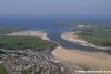
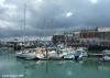
Padstow Harbour
Your Comments: 10 Read or add your comments
Courtesy Flag
Flag, Red EnsignWaypoint
None GivenCharts
Admiralty 1168, 1156, SC5603/SC5608Rules & Regulations
UnknownHazards
Bar Dangerous in WesterliesTidal Data Times & Range
HW= Dover -0550 MHWS 7.3m, MHWN 5.6m, MLWN 2.6m, MLWS 0.8m (links)This site is designed for slower, roaming broadband connections, like you would get at sea, so it needs JavaScript enabled to expand the text.
Approach
Approach from the south-west involves giving Trevrose Head a suitably ... read more
Your Ratings & Comments
10 comments
Padstow
Written by Ken Budd | 16th May 2024
May 2024 the Iso mark is know SHM all else is correct on a small neap tide range 2.5m gates opened 1 1/2 hr before HW not 2 hr
Trevose Head overfall & electricity hook up
Written by Chris99 | 29th Apr 2024
We entered Padstow from the South West in variable winds last week and found a lively overfall off Trevose head/Dinas Head. Nothing too bad, but enough to turn the autohelm off and take the wheel.
We were 1.2nm from Dinas head and well clear of the rocks. I would give this a wider berth in anything but very calm seas.
We came in quite late and took some time to reverse into a berth (the boat just won't steer in reverse!). HM was very helpful and welcoming, but I forgot to ask for an electricity card and only remembered in the pub about 30 minutes after checking in. By that time the office was shut so we didn't have shore power for the night (left at 5am the next morning so no big deal), but remember to ask for a card!
1 of 1 people found this helpful
UPDATE December 2022
Written by Don Thomson 3 | 15th Dec 2022
There is a NEW video of the approach to Padstow harbour and we've updated the link to that
0 of 1 people found this helpful
UPDATE SEPTEMBER 2022
Written by Don Thomson 3 | 30th Sep 2022
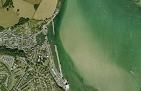
I reviewed these notes at the end of September 2022. There seems to have been a gentle movement of the sandbanks on the Eastern side of the run in to Padstow. They move the buoyage as necessary, but you would be wise to check the Notices page on their web site before visiting there in 2023. They are revamping their website this autumn so any links you (or we) have stored may need changing.
UPDATE SPRING 2021
Written by Don Thomson 3 | 28th Sep 2021
I reviewed these notes in September 2021. The approach notes have been completely rewritten to account for the new buoyage into Padstow and you should edit any stored waypoints on your plotter. Otherwise all is the same and the welcome always good.
1 of 1 people found this helpful
UPDATE SPRING 2018
Written by Don Thomson | 24th Apr 2018
This harbour is the complete package. Take the trouble to look at the navigation page on their website for a complete video of the way in. The price is the same as it has been for years and they have two amenities blocks these days.
1 of 1 people found this helpful
Si Ricketts, Westerly Ocean Ranger, July 2017
Written by Simiester | 10th Jul 2017
Can't agree more with the earlier comments, great little harbour with plenty of life and lots to do.
I couple of comments regarding mooring up. We rafted up against someone on the harbour wall, to port as you come out of the lock. We had to lend the inside boat our fender board as he was having problems keeping the hull off the prominent vertical girders on the wall. We found out later that the HM keeps boards for free loan if you haven't got one.
Also, fuel can be picked up by jerry, a service that the HM provides FOC, alternatively we filled up directly by coming along side the pier to the starboard side of the outer lock entrance. You can't miss the large green tank on the pier. You must moor close to the outer end of the tank otherwise the hose won't reach. Contact the HM when you arrive and he will come over and sort things out. Card payment has to be at the office so best to do it on your way in. Enjoy.
3 of 3 people found this helpful
Update Spring 2016
Written by dononshytalk | 28th Apr 2016
These notes were reviewed by Don in April 2016. There has been a small increase in price.
Update 2013
Written by dononshytalk | 19th Feb 2013
The notes for Padstow were updated by Don T on 19th February 2013. No changes were necessary but a couple of bits of local knowledge were added.
Tom Webb, around Britain on a 21' Beneteau 2011
Written by Tom Webb Sailing | 31st Oct 2011
21-22/8 – Padstow – Padstow is another of my favourite places, you enter through a very clearly marked channel which is very clear even at night, you then come to the lock which normally opens for free flow so you don’t have to lock in and out, the small harbour is brilliant although if you come alongside the wall expect a lot of rubbish from the street on decks the next morning! However you just have to walk off your boat to be in the centre of a fun buzzing town and arms reach of the local pubs. Padstow is a fantastic place to visit and I really recommend it!
2 of 2 people found this helpful

© visitMyHarbour.com | website design created by Black Culm Ltd