You are viewing the expanded version of this Harbour,
for faster browsing
use the regular version here

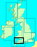
Padstow Harbour
Courtesy Flag
Flag, Red EnsignWaypoint
None GivenCharts
Admiralty 1168, 1156, SC5603/SC5608Rules & Regulations
UnknownHazards
Bar Dangerous in WesterliesTidal Data Times & Range
HW= Dover -0550 MHWS 7.3m, MHWN 5.6m, MLWN 2.6m, MLWS 0.8m (links)This site is designed for slower, roaming broadband connections, like you would get at sea, so it needs JavaScript enabled to expand the text.
General Description
Contacts
Harbour Master tel 01841 532239 VHF #12
Padstow Harbour, North Cornwall, lies about 50 miles to the north-east of Land's End. The North Cornwall coast and indeed the Bristol Channel have worrying connotations for small craft navigators. The whole of North Cornwall can become a very dangerous lee shore for sailing vessels, and the further one penetrates into the Bristol Channel the more powerful the tides get.
Many fine sailing ships met their end on this coast (including the Maria Assumpta in 1995), and the inhabitants used to be well-known for their (alledged) wrecking activities. Nowadays with GPS position fixing equipment, timely weather forecasts, and reliable diesel engines things are somewhat different. Even so, many Mariners on passage North or South scurry past the whole Bristol Channel/North Cornwall area as quickly as they can.
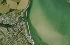
Padstow, located within the Camel estuary, is guarded by the Doom Bar... the name alone is enough to make one wary. Doom is in fact derived from "dune" as in sand dune, and although it's claimed its fair share of sailing ships most of these were a result of the vessel losing its wind and steerage way after rounding Stepper Point (see the history section). Padstow Bay is open to the West and the North.... gales from these directions especially if prolonged enough to generate a large swell will produce spectacular results on the Doom Bar.
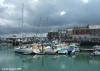
Nevertheless Padstow can offer one of the few secure stopping places along this coast, where a boat may lay afloat virtually in the centre of the pretty little town. In settled summer weather, or even if it's blowing hard from any direction that doesn't have west in it, the entrance is straightforward enough.
The harbour consists of an outer tidal part, and an inner section that is closed by gates that open in general two hours either side of high water. Some pontoons have been laid, and the harbour authorities are welcoming to yachts.
All the usual small town facilities are available, and celebrity chef Rick Stein runs various restaurants and cafes in the town for foodies...
The town is well known for its 'Obby 'Oss Festival around May Day where a giant horse like puppet character tries to capture young maidens. Rustic music, flowers and singing and dancing accompany the procession in a display of pagan merrymaking. For further details on this see the history section. This festival is somewhat of a Mecca for yachtsmen from far and near and if you stop here that weekend you will find the harbour very, very crowded and the facilities (especially the showers/toilet block) somewhat overwhelmed; but it is one blazes of a party!
Approach
Approach from the south-west involves giving Trevrose Head a suitably
....... wide offing to avoid the off lying rocks (The Quies). Once around this a course can be set for Stepper Point, passing inside of the 28 m high (and thus very conspicuous) Gulland Rock. Gurley Rock and Chimney Rock are two shallow patches with 3 m and 2.3 m over them at CD respectively.
In calm weather with any rise of the tide they should not pose a problem, but at low water or in livelier conditions it may be best to avoid sailing over them by passing closer to Gulland Rock which is fairly steep to.
Stepper Point has a white daymark, which is clearly visible from sea, and the Point is lit LFl.10s for a night approach. The Gulland Rock is unlit, and the safer approach at night would involve passing outside of this altogether and approaching Stepper Point when it's bearing Southeast from your position offshore.
Further Pilotage Details inc Harbour Entry:
Padstow Harbour has a good video of the approach which you can access from their website or from this link which will open in a separate tab:-
An approach from the north-east involves giving a good offing to The Mouls, Rumps Point, and Newland Rock, before swinging SSE for the final approaches.
Crossing the bar will involve a suitable rise of the tide... three hours before high water is probably ideal, and this will give you time to get to Padstow inner harbour when the gates are due to be opening.
As mentioned before in strong winds with a westerly component the entrance can be treacherous even at high water, with big swells and breaking seas. In these circumstances an anchorage can be found tucked into the south-west corner of Port Quin Bay as shown on the chart... this anchorage is good for south-westerlies and westerlies, but obviously in strong north-westerly conditions the whole north Cornwall coast needs a very good offing.
The final approach involves locating the channel which lays much closer to Trebetherick Point on the eastern side, rather than Stepper Point on the Western side. If rounding Stepper Point do not head directly for the Greenaway Buoy as there is a spit developing out from the Doom Bar North Eastwards. Approach to this first pair of buoys ( Greenaway and the new danger mark) should be made with them bearing just West of South, and this will keep you clear of the Rocky ledges extending westwards from Trebetherick Point and and the edge of the Doom Bar. The red can Greenaway buoy (Fl(2)R.10s) marks the edge of the rocks, (lying about one cable into the channel) and a new Black/Red/Black danger mark ( known locally as the Antoinette Buoy) to the West of the Greenaway Buoy, marking a wreck there and should be left to Starboard.
After this there is a series of new buoys and, also, the Doom Bar buoy has been moved to seawards of its old position. So, in sequence, you come to the Doom Bar conical buoy to starboard followed by the Red Daymer Mark and then head towards Gun Point where the channel is marked by a green conical buoy to starboard and another new Port Hand Mark/Buoy (Brea Spit) to port. There is a further new PHM (Brea Beach) before you come to the red and green can Channel buoy (Fl.R.5s) which marks the division of the channel to Padstow on the starboard hand and Rock to the port. if heading for Padstow harbour you will need to hug the St Saviours shore. That is marked by a beacon with a green top mark (LFlG.10s).... keep close to the shore, there is enough water from half tide onwards. Outboard of this channel to the East there is a large drying bank, and the flood tide will be trying to deposit you on this if you stray too far from the shore.
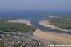
Closer in towards the harbour are another couple of buoys, a red can buoy (Fl R, Brabyn's Yard) a green conical buoy (Q.G, Kiddle Rock)) near the western shore (leave to starboard), and a red can buoy (Q.Fl.R, Town Bar) not far off the Northern harbour wall. The channel runs very close to the harbour wall at this point, leave the red buoy to port. One of the photos in the gallery shows the large drying sandbank just outside the harbour entrance, which you need to avoid by staying close to this harbour wall.
A turn can be made into the wide harbour entrance when it comes abeam on your starboard side, and the gates to the inner harbour will be seen dead ahead.
All the new buoys can be seen on the zoomable chart at the top right hand corner of these notes.
The harbour authorities operate on VHF channel 16 and 12 Monday to Friday 8 AM to 5 PM, and also two hours either side of high water, callsign Padstow harbour (Telephone 01841 532239). The link to their website (which has a very good video of the approach) is provided below:
http://www.padstow-harbour.co.uk/
They can be contacted to find out the gate opening times. If too early for the gates it may be possible to anchor in the Pool, just south of the red and green Channel buoy. The tidal can flow very hard in this area.
The harbour master may allow you to wait on the outside of the inner harbour walls with sufficient rise of tide.
Berthing, Mooring & Anchoring
Apart from temporary anchorage at The Pool,
...... the River Camel offers no real anchoring possibilities for the visiting yachtsman or motorboater unless you can take the ground.
If berthing in the harbour, follow directions from the harbour master and berth alongside in the inner harbour. There are maintained depths of between 3 m and 4 m within. Harbour dues in 2022 are £2.14 per metre per night with reductions for a weeks stay.

The intrepid Mariner with a shoal draft craft may like to chance his luck on a mission inland to Wadebridge. The channel isn't really marked and there aren't any truly convenient places to dry out either. There is a boatyard and a sailing club however.
Facilities
Although not a Marina all kinds of facilities are available here to the visiting yachtsman. Freshwater and electricity are available at all the berths, with the electricity operated by cards purchased from the harbour office.
There are good toilets, showers and laundry facilities available at the harbour office on the South Quay and also at a red brick building on the North Quay.
Both Calor and camping gas are obtainable from the harbour office too, with diesel available from the fuel berth alongside the outer pier (best done on the way in) Diesel and petrol in cans can be filled twice daily by harbour staff who make a run to the local petrol station for you. Times are 9 AM and 4 PM.
Chandlery, Marine engineering, and boat repairs are all available locally. Padstow Sailing Club is adjacent to the inner harbour.
There is a reasonable range of shops in the town for provisioning including Tesco's, but public transport from Padstow is not that brilliant. The nearest mainline station is Bodmin Parkway, and this connects to Padstow with a bus service. Wadebridge about 4 miles away has coach connections to London, and this too is connected by local bus to Padstow. Finally Newquay Airport (Ryanair etc) is also connected to Padstow by a bus service.
For the trailer sailers there are a couple of launching opportunities in the area, the first being the harbour slipway at Padstow itself. This is available at half the tidal range and slopes down into the outer harbour. It has high walls either side and it's probably more suitable for smaller boats, reversing down it looks tricky. Harbour dues are payable. (01841 532239).
On the other side of the Camel estuary (more or less opposite Padstow) is the village of Rock, a popular little holiday spot. Rock Sailing Club (01208 862431) has a slipway here which is available at three quarters of the tidal range. Again, harbour dues must be paid before using the slip and temporary membership of the club is available except in August.
A bit away from the club there are further slipways at Ferry Point, which are best used at half-tide onwards. Harbour dues payable to the beach master and vary according to the size of vessel, with boats of less than 10 hp paying the least.
There are very strong tidal flows around this area so care will be needed.
History
Padstow is a small town, civil parish and cargo port on the north coast of Cornwall, England, United Kingdom. It lies within the administrative district of North Cornwall. The UK Census 2001 reported a parish population of 3,162.
Geography
Padstow is located approximately 14 miles north and east up the coast from Newquay, at the mouth of the River Camel. The approach to Padstow Harbour is notorious for the presence of the Doom Bar, a very dangerous sand bar which has caused many ship and small boat wrecks.
Footpaths and seaways
The South West Coast Path enables walkers to explore this spectacular section of coast, with Stepper Point and Trevose Head within an easy day's walk. The path crosses the river using the Black Tor Ferry, which carries pedestrians between Padstow and Rock. Another long-distance footpath known as the Saints' Way starts in Padstow and ends at Fowey on the south coast of Cornwall.
During the mid-nineteenth century, ships carrying timber from Canada (particularly Quebec City) would arrive at Padstow and offer cheap travel to passengers wishing to emigrate. Shipbuilders in the area would also benefit from the quality of their cargoes. Among the ships that sailed were the barques Clio, Belle and Voluna; and the brig Dalusia.
Economy
Traditionally a fishing port, Padstow is now a popular tourist destination; although some of its former fishing fleet remains, it is mainly a yachting haven on a dramatic coastline with few easily navigable harbours. The influence of restaurateur Rick Stein can be seen in the port, and tourists travel from long distances to eat at one of his restaurants or cafés. However, the Stein led boom has caused rocketing house prices in Padstow and surrounding areas, as people buy second or holiday homes there. This has meant significant numbers of locals cannot afford to buy property of their own now, with prices often well over 10 times the average salary of around £15 000.
Culture
'Obby 'Oss festival
Padstow is best known for its "'Obby 'Oss" festival. Although its origins are unclear, it most likely stems from an ancient fertility rite, perhaps the Celtic festival of Beltane. The festival starts at midnight on May Eve when townspeople sing the "Morning Song". In the morning, the town is dressed with greenery and flowers are placed around a maypole. The climax arrives when male dancers cavort through the town dressed as one of two 'Obby 'Osses, the "Old" and the "Blue Ribbon" 'Obby 'Osses; as the name suggests, they are stylised kinds of horses. Prodded on by acolytes known as "Teasers", each wears a mask and black frame-hung cape under which they try to catch young maidens as they pass through the town. Finally, at midnight on May Day, the crowd sings of the 'Obby 'Oss death, until its resurrection the following May Eve.
Mummers' or Darkie Day
On Boxing Day and New Year's Day, it is a tradition for some residents to don blackface and parade through the town singing 'minstrel' songs. This is an ancient British midwinter celebration that occurs every year in Padstow and was originally part of the pagan heritage of midwinter celebrations that were regularly celebrated all over Cornwall where people would guise dance and disguise themselves by blackening up their faces or wearing masks. (Recently the people of Penzance have revived its midwinter celebration with the Montol Festival which like Padstow at times would have had people darkening or painting their skin to disguise themselves as well as masking.)
Folklorists associate the practice with the widespread British custom of blacking up for mumming and morris dancing, and suggest there is no record of slave ships coming to Padstow. Once an unknown local charity event, the day has recently become controversial, perhaps since a description was published. Also some now suggest it is racist for white people to "black up" for any reason. Although "outsiders" have linked the day with racism, Padstonians insist that this is not the case and are incredulous at both description and allegations. Long before the controversy Charlie Bate, noted Padstow folk advocate, recounted that in the 1970s the content and conduct of the day were carefully reviewed to avoid potential offence. The Devon and Cornwall Constabulary have taken video evidence twice and concluded there were no grounds for prosecution. Nonetheless protests resurface annually. The day has now been renamed Mummer's day in an attempt to avoid offence and identify it more clearly with established Cornish tradition. The debate has now been subject to academic scrutiny.
History
Padstow was originally named Petroc-stow, after the Welsh missionary St. Petroc, who landed at nearby Trebetherick around AD 500. After his death a monastery was established here which was of great importance until the town was raided by the Vikings (the monks moved inland to Bodmin). In the medieval period it was commonly called Aldestowe (as the 'old place' in contrast to Bodmin the 'new place').
Padstow isn't usually thought of as a "Viking town", but it was probably near Padstow that in 722 AD the Britons of Cornwall united with the Vikings of Denmark to destroy an invading Anglo-Saxon army led by Ine of Wessex at "Hehil". The Saxon army was slaughtered, and this decisive battle gave Cornwall 100 years of freedom from attacks by Wessex. The Annales Cambriae is the source for the battle at Hehil.(However, it is not stated whether the Cornish fought the West Saxons or some other enemy.)
Further along, the coastal path, on the cliff top, is an abandoned manual capstan. For ships entering the bay with a SW wind, a great hazard was caused by the immediate loss of wind power due to the cliffs. Rockets were fired from the cliffs to place a line on board to allow ships to be winched or warped in more safely. Padstow was notorious for ships becoming becalmed and swept onto the Doom Bar.
Doom Bar.
The Doom Bar is a bank of sand at the estuary of the River Camel where it meets the Celtic Sea on Cornwall's north coast. It represents a significant hazard for sailors, and there have been many ships wrecked upon it over the centuries. Cornish legend tells of its creation by the Mermaid of Padstow as a dying curse against sailors. It has been the subject of poetry and has now had a popular bitter by Sharp's Brewery named after it.
Location
Located at the estuary of the Camel River, the Doom Bar is a sandbank which acts as the only defense between the estuary and the Celtic Sea.
Legend
According to legend, the Mermaid of Padstow created the Doom Bar as a dying curse, after being shot by a sailor. However, there are many different versions of the story and the precise details are unclear. Some versions start by stating that she used to guide ships up the estuary and others that she would visit and spy upon ships in harbour, yet more tell of how she used to sit upon a rock at Hawkers Cove.
She then met a man, and one fell in love with the other. One version explains that she was love sick, and tried to lure him beneath the waves, however he escaped by shooting her. Another version suggested the man, Tristram Bird, fell in love with her and asked her to marry him, though she refused. In his rage he shot her. Another suggestion is that a fisherman shot her because he thought she was a seal.
The ending of the legend is generally similar. With her dying breath, she leveled a curse at Padstow, or at the harbour itself, stating that the harbour will be desolate or unsafe. With that, a great storm came, wrecking many boats and creating the great sand bank known as the Doom Bar.
Shipwrecks
For centuries, the Doom Bar was regarded as a significant danger to ships — to be approached with caution or end up run aground. In fact, it has accounted for around 600 wrecks since records began about 200 years ago. When sails were the main power source, ships would regularly come round Stepper Point and would then lose their wind, leaving them to drift. Even if they were to drop anchor, it would gain no purchase on the sand. If the tide was low, it was only a matter of time before they hit the Doom Bar.
However even with motor power and as recently as 12 November 1911, there were two ships wrecked upon the sand bank on one day. The Island Maid, a schooner, had hit the Doom Bar, was in distress and headed towards the harbour. The 1911 Lifeboat team mounted a rescue, and the full crew of five were brought safely to the shore. The Island Maid itself went down near the Doom Bar, where it still rests to this day and is often used for diving expeditions.
The Angele, a brigantine, ran aground soon after, but as the tide had turned and the evening was drawing in, the lifeboat was unable to reach the Angele. When they managed to mount a second attempt at rescue, they reached the ship and rescued the sole survivor, who turned out to be the ship's Captain.
For their intrepid rescues that day, three members of the lifeboat crew, Mr J. Horst, Mr F. Reynolds and Mr. W. Cook were awarded the thanks of the National Lifeboat Institution on 28 February 1912.
The most recent (and infamous) wreck, that of the Maria Asumpta, was in 1995. This ship ran aground after its engines failed and the skipper found himself too close to a lee shore in Port Quin Bay. Being a square rigger he was "embayed" and there was no way out. She went down with the loss of three lives and the skipper ended up in prison for manslaughter.
The text on this HISTORY page is covered by the following licence
http://en.wikipedia.org/wiki/Wikipedia:Text_of_the_GNU_Free_Documentation_License
Eating, Drinking & Entertainment
For eating out in Padstow the first thing to realise is that the place has been Rickensteined. Celebrity chef Rick Stein has been making himself very busy in this pretty little town, having opened no less than four eateries, a delicatessen, a patisserie, a gift shop, a cookery school and has over 40 rooms for guests staying in Padstow.
For the gourmand mariner this could prove a good reason for visiting Padstow, where they will have a choice of The Seafood Restaurant, St Petroc's Bistro, Rick Stein's Café and Stein’s Fish & Chips. The problem is naturally that everyone else wants to eat at one of these establishments and you need to book weeks in advance during the summer. We provide a link to his website below:
Although there are other eateries in town, those of simpler tastes who might prefer 6 pints of Guinness followed by a tasty vindaloo may be disappointed...
A link is provided below that deals with the local pubs:
http://www.beerintheevening.com/pubs/results.shtml/el/Padstow%3BCornwall/
Links
|

Your Ratings & Comments
We were 1.2nm from Dinas head and well clear of the rocks. I would give this a wider berth in anything but very calm seas.
We came in quite late and took some time to reverse into a berth (the boat just won't steer in reverse!). HM was very helpful and welcoming, but I forgot to ask for an electricity card and only remembered in the pub about 30 minutes after checking in. By that time the office was shut so we didn't have shore power for the night (left at 5am the next morning so no big deal), but remember to ask for a card!
I couple of comments regarding mooring up. We rafted up against someone on the harbour wall, to port as you come out of the lock. We had to lend the inside boat our fender board as he was having problems keeping the hull off the prominent vertical girders on the wall. We found out later that the HM keeps boards for free loan if you haven't got one.
Also, fuel can be picked up by jerry, a service that the HM provides FOC, alternatively we filled up directly by coming along side the pier to the starboard side of the outer lock entrance. You can't miss the large green tank on the pier. You must moor close to the outer end of the tank otherwise the hose won't reach. Contact the HM when you arrive and he will come over and sort things out. Card payment has to be at the office so best to do it on your way in. Enjoy.