Folkestone Harbour
Courtesy Flag
Flag, Red EnsignWaypoint
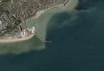
Breakwater End 51:04'.557 N 001:11'.716 ECharts
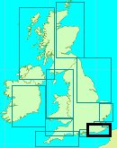
Admiralty, 1991, SC5605Rules & Regulations
Suitable for Overnight/Short Stays OnlyHazards
Rocky Ledges to E and W of Harbour, Outer Harbour Dries.Tidal Data Times & Range
HW -0020 Dover MHWS 7.1m MHWN 5.7m MLWN 2.0m MLWS 0.7m. Tide-tables: (links)This site is designed for slower, roaming broadband connections, like you would get at sea, so it needs JavaScript enabled to expand the text.
General Description
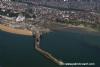
Folkestone lies a few miles to the west of Dover, and is easy to recognise from sea with it's single large breakwater. ... read more
Approach
Approaches to Folkestone from the south-west through to the east are basically clear of danger. ... read more
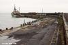
Berthing, Mooring & Anchoring
With a sufficient rise of tide it is possible to enter the outer harbour between the East Pier and South Quay. Basically the Harbour does not provide any facilities for visiting skippers. They quote £25 + VAT for mooring but there are no moorings! There is a trot of moorings rented out to the local yacht club and you could contact them to see if one is spare for a night or so, but that would be a private arrangement with the owner of the mooring and nothing to do with the harbour. Their telephone number is 01303 251574 and there's someone around Tuesday, Wednesday or Friday eveings ... read more
Your Ratings & Comments
The outer harbour (see chart - it may not be what you think) dries and I was obliged to enter on a falling tide. I ground to a halt within a few yards of the only visitors' buoy (white, close to the entrance, dries 3m) and picked it up later in the evening when I floated off again. The buoy rope was badly frayed and unusable but I replaced it (to thanks but no reduction in the £25 mooring fee). The harbour is open to the SE, so probably uncomfortably, even untenable, in a wind from that quarter. Steph, in the office was very helpful.
Pleasant walk up The Old High Street and lunch in the aptly named, busy and pleasant Steep Street café.
Off to Dover.
http://www.folkestoneharbour.com/pages/harbour.html