You are viewing the expanded version of this Harbour,
for faster browsing
use the regular version here

Falmouth 4, The Upper Reaches as far as Truro
Courtesy Flag
Flag, Red EnsignWaypoint
Safe Distance SW of Turnaware Bar Buoy 50:12'.345N 005:02'.235WCharts
Admiralty, 32, 154, 18, SC5602Rules & Regulations
Speed Limit 8Knts, Minimal Wash in the upper reaches, past TurnawareHazards
Turnaware Bar, Dries above MaplasTidal Data Times & Range
Truro, HW 8mins after Falmouth (links)This site is designed for slower, roaming broadband connections, like you would get at sea, so it needs JavaScript enabled to expand the text.
General Description
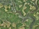
Heading north up the river past Turnaware Point, the character of
...... the River changes dramatically as instead of acres of open water, the shores close in and are fringed with cliffs and trees.You are now in the jurisdiction of the Truro port authority, and they provide various mooring buoys, yacht pontoons (see below for prices) and collect anchoring charges at a flat rate of £7 per night.
There are numerous places where a yacht can go and get plenty of peace and tranquillity, but stocking up could be a problem. You may be surprised to find huge ships laid up in the river. The intrepid explorer, prepared to take the ground, can follow the river right up to the city of Truro on a rising tide, where stocking up will almost certainly not be a problem.
Alternatively there is a regular ferry running between Falmouth and Truro; sit in the sun and let them bother about the depths!!
Other Falmouth coverage which can be reached via the links below or the Channel West link on the left of this page:
Falmouth 1, approach, entry, Inner Harbour, Penryn River
Falmouth 2, St. Mawes, Percuil River
Falmouth 3, Carrick roads, as far as Restronguet Creek, including Mylor and its Marina
Approach
The main thing to remember as you approach Turnaware Point, is that
..... Turnaware Bar stretches out from the eastern shore (Turnaware Point), and it dries. It is a well-known yacht trap, and to avoid it one should keep to the western side. It is marked by the Turnaware Bar Buoy, (Green, Fl.G.5s), which needs to be left on your starboard side as you head north. The tide can run quite strongly in this area at Springs, achieving 2 or 3 kn, as the River is now constricted on both sides.
The River is deep, and as you head north if you stay fairly central between the banks you will have no problems. It is steep too on either side. Pass the chain ferry at King Harry passage, and keep heading north, you will see large mooring buoys, and by following the line of these you will come to a point where the River swings sharply to the East. Again the large ship mooring buoys give the clue and on the southern shore you will see Smugglers Cottage restaurant with its associated pontoon. A fork now appears in the River, with the River Fall petering out into the drying Ruan Creek, and the deepwater making a hard turn northwards and becoming the Truro River. You will see an isolated visitors pontoon for yachts here, leave on your starboard side as you head north. The River starts to shallow out now, and an eye needs to be kept on the tide. More pilotage details:
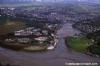
Pushing further northwards now and using the moorings, pontoons, and buoyage as a guide, remembering the deepwater lies fairly centrally, one will come to Mopus Reach (as the River swings to the West shortly after passing a visitors pontoon on the western side) and its associated small craft moorings and visitors moorings. This area south of Malpas Point and north of Kea Wood marks the last place that a yacht of average draft can lay afloat at all states of the tide.
For those making their way to Truro the next part of the passage is best attempted on a rising tide. At Malpas Point there is basically a T-junction, and for Truro one needs to make a turn to port, firstly going South West then swinging round to the north-west at Victoria Point, leaving the green buoy to starboard. You will need a good rise of the tide for this as depths at CD are as little as 0.1 m, ie. Little more than a gutway. Heading West the channel is now marked by buoyage, the channel now swinging northwards to hug the eastern shore (leaving the red buoyage to port). After passing the quay at Sunny Corner, a sharp turn needs to be made to starboard, and the best water will be found by the Lighterage Quay on the western bank of this inlet, leading to the tidal barrier. This gate is 12 m wide and is normally kept open unless very high tides are expected. Small coasters sometimes use the Lighterage Quay, and you will find a waiting pontoon if the gate is closed, or the tide hasn't risen enough to get you to the Town Quay. The tide can run quite hard through the gateway, as it is a narrow restriction or broad expanse of water.
Once through the barrier the way is marked by a series of red and green beacons, as the navigable gutway first swings North-east, North, North West, and then North-east again, forming an S shape. The river narrows right down with Tesco's on the port hand side, and the deepest water closer to the old warehouses on the starboard side. The River now divides into three branches, yachts berth in the port hand branch by the harbour office. There is water for around one and a half hours either side of HW, drying to soft mud . The authority encourages visitors, and may be able to assist larger vessels in making the passage. The harbour office is on VHF channel 12, callsign " Carrick One", or telephone 01872 224231 or 01872 272130. A link to the website is below:
Berthing, Mooring & Anchoring
Mooring options for the yachtsman or motorboater include anchoring,
......mooring buoys, pontoons, Malpas Marina and finally alongside and drying out at Truro. This section of the pilot guide covers anchorage, moorings, facilities and eating and drinking places, as in this stretch of the River everything is spread out, and we can cover each area one at a time.
As mentioned before, stretch of water comes under the authority of the Port of Truro, and they provide the many visitors moorings and pontoons, and also charge for anchoring. Berths on the visitors pontoons and moorings are charged at a flat rate of £18 a night up to 12 meteres or £14.80 per metre per night for ten visits. If you just want to drop anchor somewhere quiet and away from the madding crowd you would be subject to the Visitors Harbour charge of £7. The harbour master's launch is on VHF channel 12 callsign " Carrick Three" with the harbour authority at Truro on the same working channel, call sign " Carrick One". The launch collects Harbour Dues, and will give advice. Perhaps the best way to see what is available is to look at the plan rather than the charts. Find out more:
Another fun way to explore this section is using the interactive facility to swoop around and examine places of interest. Link below:
http://maps.google.co.uk/?ie=UTF8&ll=50.250059,-5.038605&spn=0.053456,0.109863&t=h&z=13
Having just passed the Turnaware Bar, anchorages are available in Channals Creek, to the north, and on the edges of Tolcarne Creek to the South. Always keep out of the main channel, as it is used by many tripper boats and the occasional coaster. The first harbour authority pontoons will be seen, and may be used. Depending on the fortunes of international sea trade, one may find large ships laid up in King Harry Reach, secured fore and aft. There are now extensive mussel farms in this reach, and some care will be needed if sailing not to get tangled in them. The chain ferry crosses the river here, and never try and cut in front of it as the chains are taut. The pontoon just downstream of the ferry is for local tripper boats, and you are not allowed to berth on the outside of this. Boats can tie up to the inside of the down river end to get water from the tap, if the tide is suitable (not much depth at low water). Dinghies use the inside of the up river end.
The next anchorages are available at Lamouth and Cowlands Creeks, both very attractive but drying virtually as far as the boats moored at their mouths. Anchorage is between these moorings and the deeper water channel. Bilge keeelers can explore as far as the hamlets of Coombe and Cowlands and dry out on the foreshore. Public phone at Cowlands.
The Smugglers Cottage at Tolverne Point has been closed for several years.
At the next junction the rivers divide with the River Fal petering out into Ruan Creek, and the Truro River swinging to the north. Anchorage can be had in the entrance to Ruan Creek on the north side. There are isolated dangers (3 Huge mooring blocks ) marked by a yellow pole with an X top mark, keep well clear. Bilge keeelers can nose in and dry out on the southern shore of Ruan Creek, but there is a voluntary restriction on anchoring once past the first bend. For those desperate for a pint a dinghy mission 3 miles inland to Ruan Lanihorne, up Ruan Creek, will be rewarded by the King's Head pub a few minutes walk from the old landing quay. Obviously a close eye will be needed on timing the tide.
After swinging North up the Truro River, the next harbour authority pontoon will be seen, and anchorage can also be had in this reach anywhere out of the main fairway. An anchor light should be displayed at night. A little further north still, the river shallows rapidly in an area known as Maggoty Bank, marked with a green buoy.(Depths of less than half a metre at LAT). It then deepens out again and there is another harbour authority pontoon as one swings to port into Mopus Reach. The tide runs hard in this reach and very close attention needs to be paid to the depth despite the presence of local moorings as there is very little water at low spring tides.
There are a couple of visitor's buoys at the end of the reach leading to Malpas Point where the river splits, the shallow River Tresillion running in from the north east whilst the main channel swings port to the South West. There was a visitor's pontoon opposite Malpas Point at this junction and beyond that was Malpas Marine, telephone 01872 271260. This pontoon has now been joined to the Malpas Marina set up and is run by the Truro Port people. They may well have a mooring available for you, or for a charge will allow you to land and leave your dinghy on their pontoon if moored elsewhere. There is a toilet and shower, and water and diesel available by Jerry can. In 2022 they are charging £22.00 per night for boats under 6 metres and £25 per night for larger boats. Here you will also find the Heron Inn, which does food and overlooks the River. One tiny post office/shop and a public phone completes the picture. You will see a pontoon at Victoria Quay; that has been installed for the use of house owners in the new developement ashore and does not provide facilities for visitors. There is also a bus from here to Truro (once in the morning, again at Lunchtime and back at tea time)
Next stop as already described is the city of Truro, where all facilities are available and the boat can be stocked up once more. In fact Tesco's superstore is very close. Water available on the quay, rubbish disposal, showers and toilets, mail delivery, restaurants, cinemas and all kinds of shopping available. There are two Chandlers nearby and excellent railway connections. The town quay berth is not too salubrious, with its oozing smelly mud at low water, but no matter how much you like peace and quiet and solitude, this is really the only place to obtain provisions. After spending some time skulking and lurking amongst the quiet creeks it also makes a nice change to be back in civilisation.
Facilities
History
The earliest records and archaeological findings of a permanent settlement in the Truro area originate from Norman times. A castle was built in the 12th century by Richard de Luci, Chief Justice of England in the reign of Henry II, who was granted land in Cornwall for his services to the court, including the area surrounding the confluence of the two rivers. He planted the town in the shadow of the castle and awarded it borough status to further economic activity. (The castle has long since disappeared).
By the start of the 14th century Truro was an important port, thanks firstly to its inland location away from invaders and its prosperity from the fishing industry, but also to its new role as one of Cornwall's stannary towns for the official assaying and stamping of locally-produced tin and copper in Cornish mines. However, the Black Death soon arrived and with it, a trade recession, resulting in a mass exodus of the population and, as such the town was left in a very neglected state.
Trade returned to Truro with help from the government and the town was very prosperous during the Tudor period. Self-governance was awarded in 1589 by the granting of a new charter by Elizabeth I, which gave Truro an elected mayor and control over the port of Falmouth.
During the Civil War in the 17th century, Truro raised a sizable force to fight for the King and a royalist mint was set up in the town. However, defeat to the Parliamentary troops came in 1646 and the mint was moved to Exeter. Further disheartenment came later in the century when Falmouth was awarded its own charter giving it rights to its harbour, starting a long rivalry between the two towns. The dispute was eventually settled in 1709 with control of the River Fal being divided between Truro and Falmouth.
Truro prospered greatly during the 18th and 19th centuries. Industry flourished thanks to improved mining methods and higher prices for tin, and the town soon became the place to be for wealthy mine owners. Elegant Georgian and Victorian townhouses were built—such as those seen today on Lemon Street, named after the mining magnate and local MP Sir William Lemon—and Truro became the centre for high society in the county, being mentioned as "the London of Cornwall".
Throughout these prosperous times Truro remained a social centre and many notable people hailed from it. One of the most noteworthy residents was Richard Lander, an explorer who discovered the source of the River Niger in Africa and was awarded the first gold medal of the Royal Geographical Society. Others include Humphry Davy, educated in Truro and inventor of the miner's safety lamp, and Samuel Foote, an actor and playwright from Boscawen Street.
Truro's importance increased later in the 19th century and it had its own iron smelting works, potteries, and tanneries. The Great Western Railway arrived in Truro in the 1860s with a direct line from London Paddington, and the Bishopric of Truro bill was passed in 1876 which gave the town a bishop, then a cathedral. The next year Queen Victoria granted Truro city status.
The start of the 20th century saw the decline of the mining industry, however the city remained prosperous as its previous role as a market town shifted to being the administrative and commercial centre of Cornwall, and saw substantial development. Today, Truro continues its role as the retail centre of Cornwall but, like many other cities, faces concerns over the disappearance of many of its renowned speciality shops for national chain stores, the eroding of its identity, and also over how to accommodate future expected growth in the 21st century.
Truro is located in the centre of Cornwall approximately 9 miles (14 km) from the south coast on the confluence of the rivers Kenwyn and Allen, which both combine to become the River Truro, one of a series of creeks, rivers and drowned valleys leading into the River Fal and then onto the large natural harbour of Carrick Roads. The river valleys form a bowl surrounding the city on the north, east and west and open to the Truro River in the south. The fairly steep-sided bowl in which Truro is located, along with high precipitation swelling the rivers and a spring tide in the River Fal, were major factors in the cause of floods seen in 1988 which caused large amounts of damage to the city centre. Since then, flood defences have been constructed around the city, including an emergency dam at New Mill on the River Kenwyn and a tidal barrier on the Truro River, to prevent future problems.
The text on this HISTORY page is covered by the following licence
http://en.wikipedia.org/wiki/Wikipedia:Text_of_the_GNU_Free_Documentation_License
Links
|

Your Ratings & Comments
Now just 2 visitors buoys (yellow) at the top of channel just short of the visitors pontoon.
Coffee shop and deli now open. Good for some essentials and up-market provisioning.
Found a couple of green buoys short of Malpas without pick ups. HM told us they were "temporary" visitor buoys !
View all 16 feedback items