You are viewing the expanded version of this Harbour,
for faster browsing
use the regular version here

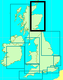
Kirkwall and the North Orkney Islands (almanac stub)
Courtesy Flag
Flag, Red EnsignWaypoint
Kirkwall 59° 00.00N 002°57.54WCharts
AC 2250-0 Orkney Islands Eastern Sheet; AC 2249-0 Orkney Islands Western Sheet; AC 1553-0 Bay of Kirkwall. Imray C68 Cape Wrath to Wick and the Orkney Islands There is no Admiralty Folio for the OrkneysRules & Regulations
Orkney VTS operates on #11. While there is no requirement for small leisure vessels to report their movements it is suggested that you listen out on #11Hazards
None that are not marked on the charts. Beware overfalls and Skerries. If you use Navionics examine every inch of your intended route at high levels of expansion.Tidal Data Times & Range
HW Kirkwall is HW Wick – 40 minutes MHWS 3.0m MHWN 2.4m MLWN 13m MLWS 0.6m (links)This site is designed for slower, roaming broadband connections, like you would get at sea, so it needs JavaScript enabled to expand the text.
General Description
Contacts:
Orkney VTS 01856 873636 VHF # 11
Orkney Marinas Ltd 01856 871313
Kirkwall Marina Superintendent 07810 465835
Westray Marina Superintendent 07775 252924
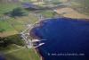
Kirkwall lies in a sheltered bay on the North side of “Mainland” Orkney at the narrowest part of the Island. It’s a small town constructed of local field stone with a population of about 9,000 which supports the Orkney Islands’ mainly agricultural population. The other town on Orkney is Stromness which we cover in our article on it and Scapa Flow in another article.
Other than agriculture the other main industry was fishing but that has changed somewhat since the boom in North Sea Oil and, as we know, that is slowly declining now.
If you intend spending a week or even more exploring these islands we strongly recommend that you make use of the Marina guide pages on planning at:-
Orkney Marinas - Sailing to and around Orkney
Another growth in their economy is tourism (and that’s where we come in!!); it is becoming a popular cruising ground for the more adventurous sailor despite its propensity for strong winds and tides. It is also becoming a destination for Cruise ships which can tie up at the facility across Kirkwall Bay from the Marina. There has been increasing interest in the archaeological sites on the Islands and one of the latest theories is that civilisation of UK started here and spread South rather than the popular belief that it was from South to North!
One distinct landmark in Kirkwall which can be seen from North or South is the red sandstone St Magnus Cathedral; in fact, if you head a smidgin to the left of it from our Waypoint you’ll arrive safely at the marina entrance!
Kirkwall harbour itself consists of two encircling arms forming a sheltered, circular area with the Marina situated on the Eastern side. There is not generally staff in attendance for your arrival as the Superintendent has a roving brief covering this and Stromness. Just tie up where convenient and get on with life. You’ll need the code to get back in to the marina so you’d need to get hold of that before setting out to explore.
Approach
The first thing that you’ll notice when you first start planning your trip to Orkney.....
..... is that there are an awful lot of charts covering the area. The charts we show with this article are a combination of those charts and, with various states of zoom you can access them all. If you plan to explore these islands in detail, you could spend another £50 on the small-scale charts available.
The next thing you will notice is that there are lots of arrows showing tidal streams of quite strong proportions all over the place and a lot of overfalls to accompany them. You should take those over-fall areas seriously, especially where there is a wind against tidal stream situation eg if you are belting West through Shapinsay Sound, towards the String and Kirkwall, with a 3 knot tide under your stern and hard pressed on the port tack, those overfalls South of Helliar Holm could well cause you some grief.
There are various places you can access the Admiralty Tidal Charts and you will need them if you are exploring these islands. There is a set on this website at:
http://www.visitmyharbour.com/articles/3164/hourly-tidal-streams-around-the-orkney-islands
and for the Pentland Firth (includes advice on transiting the Firth against the stream!)
http://www.visitmyharbour.com/articles/3163/hourly-tidal-streams-around-the-pentland-firth
Remember also that “settled conditions” here are not the norm - there’s a reason there are not many trees on the Orkneys. Apart from Hoy on the South side of Mainland Orkney the islands are not very high; there is little shelter from strong winds. You can anchor in the “lee” of islands which will shelter you from any seas but you will still be subject to strong winds unless you are tucked in close or behind a pier. You would be wise to use as much cable as you can with your anchor and consider double anchoring to a yoke.
Having issued those dire warnings, the planning is up to you, work out where you’d like to be at what states of the tide and, if you can’t make those gates, clew up in shelter and wait until you can.
If coming up from Wick you would probably like to be hitting the Pentland Skerries well to the SE end of their “tail” at slack turning ebb. It’s then 31+ miles to Helliar Holm and you’ll want to be there with the last hour of the ebb to run. There is a pass between Copinsay and Point of Ayre but, to be honest, it may save you a mile and a half but not much more. In a sub 5kt boat it may well prove wise to stop somewhere for the night and start again in the morning; tucked into Deer Sound might be a good idea.
Once you have cleared the area to the South of Helliar Holm it’s fairly straightforward; in daylight and good visibility there’s no reason why you shouldn’t nip through the gap between Thieves Holm and the Mainland, but be careful with the nav as there are a couple of shallow patches to starboard as you go through.
You do not have to go to the waypoint we have given; that’s for a safe approach in bad vis or nasty weather.
Coming from the other direction you will have to come through Eynhallow Sound from either Cape Wrath way, or Stromness. The tides through there are given as 3.5 on the flood and 2.8 on the ebb so you need to arrive early enough to get through (it’s about six miles). Again it depends entirely on the speed of your boat; I think the stream may be fairly slack up the west side of the Mainland and I’d be tempted to stay close in (This is only a guess!!!!!)
If you run out of flood tide through Eynhallow you could clew up at Brinian or Tingwall for the night (Brinian for choice, there’s a restaurant and bar on the pier) At this stage, if you are not in need of supplies you may decide to visit some of the other islands before going into Kirkwall; otherwise it’s a mere 7 or 8 miles from here to Kirkwall.
Berthing, Mooring & Anchoring
Planning your exploration of the North Isles...
There are three good sources of information for this
a. The Clyde Cruising Club Pilot, N and NE Scotland and the Orkney Islands
b. The Orkney Marina Ltd web site and publication
https://www.orkneymarinas.co.uk/plan-your-trip/sailing-to-and-around-orkney
c. The Orkney Ports Handbook which can be downloaded from
https://www.orkneyharbours.com/port-authority/info/brochures
Your best bet is to decide what you need from the two on-line publications and then download and save them to you laptop/tablet so that they are available offline.
To give you some idea of what it can be like in "gentle" weather here's a video from Dylan's Keep Turning Left collection. It's half an hour of doing what we like most in boats.
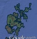
There are two marinas in the North Orkney Islands; Kirkwall and Westray. Apart from this all the larger islands have a ferry pier and quite a few of these have a couple of visitors’ buoys laid during the summer months. You can expand our Google Maps Sattelite thumbnail at the top right of this article to see the locations but that is not exhaustive. Obviously you would consider the weather forecasts before anchoring anywhere here; the land is not that high and doesn’t give much shelter from the wind - though you are unlikely to encounter any swell.
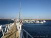
 Kirkwall Marina. This marina is inside the Kirkwall breakwaters and can take boats up to 20 metres. There is shore power and water on the pontoons and toilets and showers for berth holders ashore. You will need an access code to get into the marina. The marina also retails red diesel. Charges are simple (2022); £2.45 per metre with a minimum of £18.00. You can buy by the day, week or month and you are covered for the whole of Orkney
Orkney Marinas - Prices
After that, the town can supply all your needs; there’s a chandlery in the trading estate near the garage (where you can get petrol) and that chandlery also does outboard repairs and supplies Gas/Gaz. There are plenty of shops and services (including a laundrette) in the town and you will not be at a loss to find food and entertainment. The marina superintendent calls twice per day but if you need anything you can always get him on his mobile (he also covers Stromness Marina so he may take a while to get to you)
Westray Marina consists of two pontoons within Pierowall harbour There is shore power and water on the pontoons with toilets and showers ashore. Auto diesel and petrol (and Gas/Gaz) can be obtained in the village about a mile away. It is of interest that the new owners of the store that does the diesel/petrol is opening a café at the back and intends car and bike hire for the summer of 2017. The pub/hotel is at the other end of the village.
Facilities
We have covered what is available in the marinas above. It you click on the link below it will open a chartlet of the North Orkney Isles with the main piers indicated.
https://www.google.com/maps/d/viewer?mid=1YEWFdljPVKUWEpGwZ92QZn2WuAI&ll=59.07909872394823%2C-2.8644597500000372&z=10
Of the Piers shown, where there is a visitors buoy it is shown in the information window for that pier. Alternatively you can nearly always lie alongside overnight if you give the VTS a shout on #11. At a minimum there will be toilets ashore in the ferry waiting rooms.
Of those shown, Kettletoft Pier, Rousay and Whitehall have hotel/bars and Balfour has a café (and a licenced bakery/store) Balfour also has a castle/hotel but it’s a five star place so turning up in your oilies for dinner might be frowned on (they say their “luxury dining is available to groups of ten or more”)
Eating, Drinking & Entertainment
Kirkwall has plenty of entertainment and the Cathedral is generally considered worth a visit. Drop in to the local Tourist information Centre for gen about visits to the archaeological dig sites on the Mainland.
The last weekend in May is normally the Orkney Folk Festival; that is centred on Stromness so it’s worth taking your boat round there because it involves late nights and much carousing. It’s normally booked up a year ahead so you won’t find a bed, shed or wheelbarrow for the night that weekend!!
Places for food Kirkwall
Restaurants & Places to Eat in Kirkwall 2022 - Tripadvisor
Places to eat in Stromness
Links
None
Your Ratings & Comments
Other sources have been trawled including local knowledge so that the information given here is pretty well everything you would discover for yourself on a winters night at home. Much has been left to the intrepid explorer and we would love to hear of your own experiences to share with other like minded sailors.
As well as Kirkwall they run Stromness and Pierowall (on Westray) marina with equally friendly staff.
The Harbour Master for (nearly) the whole of Orkney is Jim Buck based a couple of miles due south of Kirkwall at Scapa in the Orkney Harbour Authority HQ 01856 873636.
The town is well worth a look around, a great cathedral and a good bus service to all the famous tourist sites of Orkney - suggest 2 full days to explore the area.
There is one other harbour in Orkney which is privately run - St Margaret's Hope in the south of the archipelago. Very friendly HM, Billy Norquay, (01856 831646). We chose to anchor in the safe harbour bay.
Enjoy the strong tides around Orkney - you can wizz around if you get it right and marvel at the Roosts (standing waves) that occur - they are well marked on the chart.