

Harbour Information (use the  icons to find out more)

Drogheda
Your Comments: 5 Read or add your comments
Courtesy Flag
Irish TricolourWaypoint
53° 43.3N 006° 12.00WCharts
AC 44 Nose of Howth to Ballyquintin Point; AC 1431-1 Approaches to the River Boyne; Imray C62 Irish SeaRules & Regulations
The dredged channel is a “narrow channel” within the meaning of the IRPCS rules and small vessels should not impede those restricted by draft.Hazards
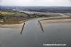
There’s a rock awash at HW just a cable and a half off to the ESE of the end of the Southern training wall; don’t be tempted to cut the corner.Tidal Data Times & Range
HW at the entrance to the Boyne is as HW Dublin, LW is LW Dublin +0025; MHWS 4.5m MHWN 3.7m MLWN 1.4m MLWS 0.5mThis site is designed for slower, roaming broadband connections, like you would get at sea, so it needs JavaScript enabled to expand the text.
General Description
Contacts: Drogheda HM VHF #11 tel +353 (0)4198 38378 ; +353 (0)86254 7827 (mobile) ... read more
Approach
The approach to Drogheda up the River Boyne is interesting but well charted ... read more
Berthing, Mooring & Anchoring
There is now a pier for the reception of visiting yachts. ... read more
Your Ratings & Comments
5 comments
UPDATE OCTOBER 2022
Written by Don Thomson 3 | 21st Oct 2022
No changes except that plans for a deep water harbour near Braymore Point seem well advanced and that it is a development by the Drogheda Port Company
UPDATE SUMMER 2021
Written by Don Thomson 3 | 26th Aug 2021
I reviewed these notes in August 2021. I've added a warning for smaller boats mooring at Fiddlers Quay but that is because, with a 6.5 m boat the mixture of dolphins, tides, springs and fender boards always ended in tears!!
Update 2017 for new pier
Written by Don Thomson | 11th Sep 2017
A new yachting peir has been added on the North side of the harbour outside the dockyard. The text has been edited to indicate this.
UPDATE APRIL 2017
Written by Don Thomson | 21st Apr 2017
Drogheda remains essentially a commercial port which they say is a busy port with no ideal berth for small craft.
Update 2015
Written by dononshytalk | 15th Apr 2015
These notes were reviewed by Don in April 2015. There is still no evidence of dedicated yachting facilities.


© visitMyHarbour.com | website design created by Black Culm Ltd