You are viewing the expanded version of this Harbour,
for faster browsing
use the regular version here

Drogheda
Courtesy Flag
Irish TricolourWaypoint
53° 43.3N 006° 12.00WCharts
AC 44 Nose of Howth to Ballyquintin Point; AC 1431-1 Approaches to the River Boyne; Imray C62 Irish SeaRules & Regulations
The dredged channel is a “narrow channel” within the meaning of the IRPCS rules and small vessels should not impede those restricted by draft.Hazards
There’s a rock awash at HW just a cable and a half off to the ESE of the end of the Southern training wall; don’t be tempted to cut the corner.Tidal Data Times & Range
HW at the entrance to the Boyne is as HW Dublin, LW is LW Dublin +0025; MHWS 4.5m MHWN 3.7m MLWN 1.4m MLWS 0.5mThis site is designed for slower, roaming broadband connections, like you would get at sea, so it needs JavaScript enabled to expand the text.
General Description
Contacts: Drogheda HM VHF #11 tel +353 (0)4198 38378 ; +353 (0)86254 7827 (mobile)
Drogheda is a large town standing astride the River Boyne 5 miles from its mouth. It has a busy port facility with a cement works and a container terminal at Tom Roe’s Point, both of which are down river from the viaduct crossing the river to the East of the town. The main port area is on the North bank of the river just upstream of the viaduct which, with an air draft of 27m, should not cause a problem to the average cruising yachtsman; however the footbridge a couple of hundred yards further up the river will be impassable to a masted yacht and even a fairly small river cruiser.
They added a new pier for the use of visiting yachts in 2017. Known as Fiddle Case Pier, it is situated about 400 metres above Viaduct, abeam the Merchants Quay and outside the dockyard entrance
There has been a town here at the lowest crossing point on the river for centuries and it has been fought over many times. Cromwell carried out a well documented (and still remembered) massacre here and, of course there was the famous battle between the contenders for the English throne in the 17th Century which was won by William (a Protestant) over James (a Catholic) and has been the focus of bitterness ever since.
Just over the footbridge on the South side of the river a large newly developed shopping mall dominating the skyline but the main shopping streets are on the North side of the river in narrow lanes vibrating with life. You’d be doing yourself and the shop keepers a disfavour if you confined your search for supplies to the shopping mall and surely a beverage in one of the small bars which abound on the North bank would beat a Starbucks equivalent in a Mall any day
Approach
The approach to Drogheda up the River Boyne is interesting but well charted
...... and marked so should cause very little problem once the outer channel marks have been identified. Any wind above Force 5 from the Easterly quadrant will make the entrance dangerous for any yacht, especially on an ebb tide coming out of the river.
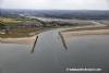
There is a lead in sector light (known as the South Bull) with a narrow white arc on the 270°T bearing which is clearly visible in daylight. The Initial Fix is quite a way out on the centre line of the approach but this is deliberate to keep you well clear of that rock off the Lyons Light (South side of the entrance).
The light on the North side of the entrance is called the Aleria light and, when approaching from the East, the sector light will appear in the middle of the 50 meter gap between the Aleria light and the Lyons light at the entrance. The Port Authority insists that shipping running up to Drogheda call them on #11 before entering the channel and visiting yachts should do so also in order that their movement be co-ordinated with the larger vessels transiting to the Container terminal or cement works.
Once through the entrance between the training walls the deep channel is well marked, though you should note that the marks lie outside the dredged channel(see photos); it sweeps round gently to starboard before straightening and arcing slowly all the way round to a SW and then WSW reach beneath the viaduct into the centre of the town and the port. At Burrow Point there is an old disused jetty where it would be possible to tie up for a night but there are absolutely no facilities here and access to it from the land is controlled.
Berthing, Mooring & Anchoring
There is now a pier for the reception of visiting yachts.
..... it's on the starboard side as you proceed up river from the railway viaduct and beyond the cargo dockyard.
It consists of a pier on pilings which are placed at 3 metre intervals and has ladders to climb at low water. You will need fender boards to moor here (the harbour will supply them for planned events but not for individual visits). I would be wary of getting my rigging or hull/warps entangled with the pier on a rising tide; it looks as though there might be plenty of places for a smaller boat to get trapped under.
Be careful of the tides here; you will, of necessity make your passage up river on the flood tide and, if you arrive on the top of the tide should have no problems with the currents. On the ebb the combination of river current and tidal stream can add up to a current of 7 or 8 knots.
They are planning to do some dredging in the vicinity of the pier but, at the moment, deeper draft vessels should expect to bottom out on the mud at LWS
Anchoring anywhere in the river, clear of the main channel, down river from Tom Roe’s Point is permitted. You would be wise to consult AC1431-2 in making your choice but there are plenty of places to be found with sufficient depth for a fin keeler and good holding in sand and mud. Your difficulty will be finding somewhere to land as the shore between HW & LW is mud.
Facilities
There is water on Fiddlers Case Pier but no shore power (and no plans for installing any)
There is no amenities building as such so there are no dedicated toilets, showers or laundry facilities for yachties.
Diesel can be delivered by tanker but petrol is by cans from the petrol station on the Dublin Road on the South side.
There are no security arrangements and the Pier is outwith the security of the main dockyard downstream.
As has been said there is a large, new shopping mall over the footbridge which has a supermarket and a cinema but there are still loads of shops on the North side where fresh provisions may be obtained; it depends on your preference.
Eating, Drinking & Entertainment
Drogheda is a fairly large town and as such has plenty of pubs, restaurants and fast food outlets.
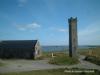
There is an old Norman mott and bailey overlooking the port on the South side which is worth a visit and a museum/visitor centre on the site of the Battle of the Boyne 5km up river from the town.
Links
|

Your Ratings & Comments