

Harbour Information (use the  icons to find out more)

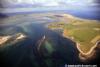
Farne Islands Anchorages and Lindisfarne (Holy Island), brief notes on Seahouses Harbour
Your Comments: 7 Read or add your comments
Courtesy Flag
Flag, Red EnsignWaypoint
None GivenCharts
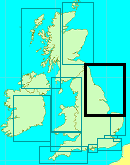
Admiralty 111, 1612Rules & Regulations
Unknown, No Landing on many of the Farnes, see text.Hazards
Lots of submerged Reefs and Rocks, Strong TidesTidal Data Times & Range
Holy Island MHWS 4.8m, MHWN 3.7m, MLWN 1.5m, MLWS 0.6This site is designed for slower, roaming broadband connections, like you would get at sea, so it needs JavaScript enabled to expand the text.
General Description
The Farne Islands (also referred to less formally as the Farnes)..... ... read more
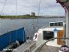
Berthing, Mooring & Anchoring
Anchorages round the Farnes centre on Inner Farne Island,..... ... read more
Your Ratings & Comments
7 comments
Anchorage 2024
Written by Bryant | 23rd Jun 2025
Visited in April/ 2024 in our 43foot motor yacht and anchored off The Heugh. Anchor set first time and we stayed a few days in this stunning location. Landing was not always easy:- at low water, the beach in the "Ouse" has thick mud extending a way out whilst the slipway is almost unusable in any sea. In HW or in calm conditions, landing is very easy. There is a fresh water tap in the boatyard at the base of the pier. As described above, at HW in south-westerly winds, the anchorage is uncomfortable. Indeed, the motion of our boat (inc some violent fish-tailing) broke the set of our anchor and we started dragging onto the lee shore of the Heugh.
Update provided by Karl June 2025
Update provided by Karl June 2025
Update June 2022
Written by Don Thomson 3 | 7th Jun 2022
No changes
UPDATE SPRING 2021
Written by Don Thomson 3 | 5th May 2021
I reviewed these notes in May 2021. Thanks to Peter Fall below for his comments; I have no changes. I've added Peter Fall's advice on Newton Haven in the Further Berthing Info but can offer no local knowledge on the approach.
Update Spring 2019
Written by Don Thomson 3 | 16th Apr 2019
Apart from changing the charts and the addition of a photograph of the nav marks at Guile Point no changes were made.
Farnes and Holy Island
Written by Peter Fall | 19th Aug 2016
Toured this area in early August and no need for changes.
An anchorage not covered is Newton Haven. It's certainly worth a visit if the tide and weather are right. Only disadvantage is the pub/restaurant is often fully booked so beer only and a bag of crisps
Peter
An anchorage not covered is Newton Haven. It's certainly worth a visit if the tide and weather are right. Only disadvantage is the pub/restaurant is often fully booked so beer only and a bag of crisps
Peter
1 of 1 people found this helpful
Update 2015
Written by dononshytalk | 10th Mar 2015
These notes were reviewed by Don in March 2105 and no changes were made
Update 2013
Written by dononshytalk | 8th Apr 2013
These notes were reviewed by Don T on the 8th April 2013.No changes were needed.
1 of 1 people found this helpful

© visitMyHarbour.com | website design created by Black Culm Ltd