You are viewing the expanded version of this Harbour,
for faster browsing
use the regular version here

Farne Islands Anchorages and Lindisfarne (Holy Island), brief notes on Seahouses Harbour
Courtesy Flag
Flag, Red EnsignWaypoint
None GivenCharts
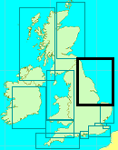
Admiralty 111, 1612Rules & Regulations
Unknown, No Landing on many of the Farnes, see text.Hazards
Lots of submerged Reefs and Rocks, Strong TidesTidal Data Times & Range
Holy Island MHWS 4.8m, MHWN 3.7m, MLWN 1.5m, MLWS 0.6This site is designed for slower, roaming broadband connections, like you would get at sea, so it needs JavaScript enabled to expand the text.
General Description
The Farne Islands (also referred to less formally as the Farnes).....
.......are a group of islands off the coast of Northumberland, England. There are between 15 to 20 or more islands depending on the state of the tide.
They are scattered about 1 1/2–4 3/4 miles distant from the mainland, divided into two groups, the Inner Group and the Outer Group. The main islands in the Inner Group are Inner Farne, Knoxes Reef and the East and West Wideopens (all joined together on very low tides) and (somewhat separated) the Megstone; the main islands in the Outer Group are Staple Island, the Brownsman, North and South Wamses, Big Harcar and the Longstone. The two groups are separated by Staple Sound. The highest point, on Inner Farne, is 19 metres (62 feet) above mean sea level.
They are uninhabited except for the wardens during the summer, and landing by boat is not allowed anywhere other than Inner Farne, Staple Island and the Longstone. The area is owned by the National trust.
They are absolutely teeming with wildlife, including a large colony of seals and various seabirds (a bit like a Northumbrian version of the Galapagos Islands). For the visiting yachtsman or motorboater there are various anchorages to be had in this area, and for those who like being at one with nature it's perfect. There are no facilities whatsoever, the nearest harbour being Seahouses (also called North Sunderland) on the mainland.
The Farne Islands are very popular with divers, and are workable in most conditions with several wrecks to investigate.
Seahouses is the base for the many trip boats servicing the islands. It dries totally and although it might be useful for a quick stop around high water to stock up on provisions (readily available ),it cannot be considered a harbour of refuge. The outer harbour is unusable in strong onshore conditions, and the small inner harbour completely fills up with all the tripper boats and fishing boats in these conditions.
This harbour is therefore not covered fully in this guide, but we do provide a chart.
For the small boat navigator the obstruction that the islands present to the tidal flow mean there are much stronger than usual streams to be taken into account, even if you're just sailing past (description soon).
Lindisfarne is a separate island from this group laying further to the north-west. It is connected to the mainland via tidal causeway and supports a small village. It is well known as being a centre of early Celtic Christianity.
The Vikings were at it here too, when they weren't wading through the mud at Grimsby they came ashore here and smashed the place up.. much to the consternation of the saintly monks in 875. Hooligans in helmets ?
It offers a decent anchorage from which to explore the island and even more shelter available for those prepared to take the ground.
All in all this group is really a must see area, perhaps the best advice is to arrive fully stocked up and be prepared for some tricky pilotage.
Quick links to nearby harbours and area coverage: Berwick on Tweed (inc. Tweed Docks) , Craster Harbour and Anchorage ,
Approach
Tidal streams need due consideration while navigating in this area.
If just passing by it is necessary to give Longstone at the northern extremity of the Farne Islands a very good offing to the north-east. Closer in the stream can attain rates of 4 kn complete with tidal eddies. This can all be avoided by keeping at least a couple miles off.
South going stream starts 1 Hr AFTER HW Dover to 6 Hr After HW Dover
Slack water 6 hrs and 5 hrs BEFORE HW Dover.
North going stream starts 4 Hr BEFORE HW Dover to HW Dover
Pilotage Details:
The Inner Sound between the mainland and Inner Farne being approximately a mile wide is easily navigable. Tidal streams can reach 2 1/2 kn here during springs.
If approaching from the South following the coast it is necessary to maintain a suitable offing and keep to seawards of the two red can buoys, the first N.Sunderland (Fl.R.2.5s) and the second Shorston (Q.R). These both mark inshore dangers you do not want to get to get tangled with. You will pass the small harbour of Seahouses mentioned in the introduction.
A generally north-westerly course from the Shoreston red can buoy will get you through the Inner Sound assuming you don't want to go and anchor around Inner Farne. Wind against tide will kick up overfalls in the sound, with the calmer water found closer to the mainland. There are dangers close inshore, but these can be cleared by staying in at least 10m at CD. There are various anchorages around the Farnes to be described shortly.
The green conical Swedman buoy (Fl.G.2.5s) needs to be identified and left well off on your starboard side to avoid the drying Megstones if passing through.
There are sectored lights to help you through here at night, but probably the best bet would be a carefully selected set of waypoints.
If heading for Lindisfarne (Holy Island Harbour), a generally north-westerly course from the Swedman Buoy will keep you in deep water until you can identify the easterly Cardinal buoy "Ridge" (Q(3)10s). This marks the start of the approach to Lindisfarne Harbour.
From a point just south of this buoy you should be able to identify the leading beacons at the north end of Old Law island, they are very conspicuous. They show the way in on a line of 260°T, and at night show a sectored Oc.WRG.6s light. The narrow the white sector of this shows the way.
Craft drawing up to 1.5 m can enter the harbour at all sides of the tide, but the seas can break alarmingly on the bar in conditions of onshore swell and low water. In these circumstances it would be much wiser to stand-off and wait for suitable rise of tide.
This line is followed inwards until you find the green conical Triton buoy on your starboard side (Q.G).
The same leading line using the beacons or the sectored light on Old Law can be used if approaching from the ENE having rounded the Farne Islands by the seawards route. The leading line will also take you South of the dangers of Stiel Reef and the drying Goldstone. It is far safer to stray to the South of this leading line than to wander north of it.
Approaching Lindisfarne from the North it will be necessary to pass between the red can buoy Plough Seat (Q.R) and the green conical Goldstone (Q.G) to avoid the above-mentioned Reef and the Plough Seat reef lying to the West. Once well past the red and green buoys it will be possible to identify and head for the Easterly Cardinal Ridge Buoy, and then pick up the leading marks recently mentioned.
Whichever way you arrive at the green conical Triton Buoy (leaving it to starboard ),it is now necessary to come off the leading line you have been following and look for the new leading marks that will lead you into the anchorage.
The general course is north-westerly, and the transit you are looking for is between the large triangular beacon on the Heugh and the Belfry of Holy Island Church. A sectored leading light on the beacon (Oc.WRG.6s) guides you in with its narrow white sector. Take note of the charted drying wreck just to the north of this leading line just as you approach the deepwater pools.
The tide can run very strongly in this close approach, up to 4 kn, therefore it would be wise to time your entry accordingly.
This whole area is one where careful pilotage is required, and a whole set of preplanned and pre-entered waypoints whacked into the GPS and marked up on your chart could take all the doubts out of it.
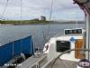
Berthing, Mooring & Anchoring
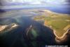
Anchorages round the Farnes centre on Inner Farne Island,.....
......and are best seen by reference to the chart (and photos). At Lindisfarne the yachtsman or motorboater can find an anchorage and also limited facilities ashore..Full details:
The Kettle is a deep water hole lying to the north-east off Inner Farne Island. The tide can run strongly through the gutway between W.Wideopen Island and Inner Farne, unsurprisingly called Wideopen Gut. Access to the Kettle Anchorage can also be had through this gutway but only near the top of the tide.
A bit of probing round with the depth sounder will find you plenty of water to anchor in, the tide being weakest near the moorings for the tripper boats.
Dinghy landings can be made at the jetty for an exploration... a chapel will be found ashore and an information centre.
Plenty of daytrippers will be encountered during the season.
Another possible Anchorage is to work your way into the deep pool North of the Wideopen Islands Islands and Knoxes Reef to the north of them. These islands are connected to the reef by a drying area, and more shelter is available here when the wind is in the West.
Finally if the wind is in the North it is possible to nose in fairly close under the Wideopen Islands and find your Anchorage in less than 10 m at CD.
Wherever you anchor around here make sure you have an exit plan in case you have to move out in darkness.
The more northerly islands don't really have any safe anchorages, but if you really want to test your pilotage skills to the max in calm conditions you will be able to view an exceptionally good variety of sea birds, and seals too.
For the yachtsman that combines sailing and scuba-diving there will be plenty of reasons for exploring this fascinating area.
Lindisfarne:
A deep water pool with over 6 m forms a good Anchorage for larger craft, while smaller craft can anchor closer inshore, roughly to the South of the triangular beacon. The effects of the tide will be felt strongly in this Anchorage, and it would be wise to make sure your vessel is attended at the turn of the tide.... also when missioning it ashore in the dinghy. Although looking totally sheltered from the chart, in strong south-westerlies or westerlies, when the causeway is covered and the tide is high this anchorage can become uncomfortable as there is a fair fetch to the sea.
Vessels that can happily take the ground can move right into the bay, with the castle to the East and the village to the West. The bottom is sandy mud.
Further Berthing Information
Peter Fall has recommended Newton Haven as a nice place to call in. We have no firm information other than that gained from the large scale chart and Google Earth. The Haven is just South of Newton Point which is five miles South of the Farne Islands. As we have no local knowledge as to the best approach, it will be up to the individual how to get in to the beach area from Newton Point but an approach from the SE would appear risky (to say the least.)
Facilities
There are no facilities in the Farne Islands, nearest possibilities for a stock up are at North Sunderland (Seahouses).
More possibilities are available to the Mariner anchored at Lindisfarne. A water tap can be found at the village green and there are public toilets with cold water washing sinks. The Village PO offers newspapers, sweets, gifts etc. The old village shop which was run by two very old ladies is now a cottage, but probably some enterprising person will take up the slack. Until then provisions could be a problem.
The place can get very crowded with holidaymakers depending on the tide times, with the island virtually being cut off for a few hours around high water. The visitor arriving on his own boat can savour the atmosphere ashore "sans tourists" at these times.
Trailer Sailers have a couple of opportunities in this area covered, the first is the slipway at Seahouses Harbour. Access is available at three quarters of the tidal range, and a launching fee is payable to the harbour master who then issues a registration plate. The slipway is only available from 8:30 AM to 6 PM. PWC's are tolerated but may only use the harbour for accessing the slipway at slow speeds. (Harbour office 01665 720033).
It is also possible to launch from the harbour at Lindisfarne. Access by car to Lindisfarne is via the causeway which of course covers either side of high water. Before use the harbour master must be paid £2 per day or £5 per week, and his house is the one nearest to the water tower (telephone 01289 389248). Launching is across the sand for light boats.
History
The Farne Islands:
History
The earliest recorded inhabitants of the Farne Islands were various Culdees, some connected with Lindisfarne. This followed the old Celtic tradition of island hermitages, found in England, Ireland, and Scotland.
The first visitor recorded by name was Saint Aidan followed by Saint Cuthbert. The latter was called to the bishopric of Lindisfarne but after two years he returned to the solitude of the Inner Farne and died there in 687, when Saint Aethelwold took up residence instead. Among other acts, Saint Cuthbert introduced special laws in 676 protecting the Eider ducks, and other seabirds nesting on the islands; these are thought to be the earliest bird protection laws anywhere in the world.
The islands have no permanent population, the only residents being National Trust bird wardens during part of the year: they live in the old pele tower on the Inner Farne, the largest and closest inshore of the islands, and the lighthouse cottage on the Brownsman in the outer group. The pele tower was built by or for Thomas Castell, Prior of Durham about 1500. There is also a chapel set up on the site of St Cuthbert's oratory 600 years ago. It was restored in recent times with old material from Durham Cathedral.
All the lighthouses on the Farnes are now automatic and have no resident keepers, although in former years they did. Ruins of older lighthouses may be seen, for example on the Brownsman where there are two. Before the lighthouses there were beacons on several of the islands. The prominent white streak on the cliff facing the mainland (see photo) is often thought by visitors to be bird droppings: although many parts of the islands do exhibit this colouring, in this case it is the result of chalk deposits from the many years of spent calcium carbide from the lighthouse being thrown down the cliff; this calcium carbide was used to generate acetylene which was used as fuel for the light before electricity came.
Grace Darling
One of the great attractions of the Farne Islands is the story of Grace Darling and the wreck of the Forfarshire. Grace Darling was the daughter of Longstone lighthouse-keeper, William Darling, and on September 7, 1838, at the age of 22 years, she and her father rescued nine people in a strong gale and thick fog from the wreck of the Forfarshire, which had run aground on Harker rock. The story of the rescue attracted extraordinary attention throughout Britain and made Grace Darling a heroine who has gone down in British folklore.
Ecology and natural history
In the warmer months the Farnes, an important wildlife habitat, are much visited by boat trips from Seahouses. Local boats are licensed to land passengers on Inner Farne, Staple Island and the Longstone; landing on other islands is prohibited to protect the wildlife. At the right time of year many Puffins can be seen and these are very popular with visitors; on the Inner Farne, the Arctic Terns nest close to the path and will attack visitors who come too close (visitors are strongly advised to wear hats). Some of the islands also support a population of Rabbits, which were introduced as a source of meat and have since gone wild. The Rabbit and Puffin populations use the same burrows at different times, the Puffins being strong enough (with a vicious bite) to evict the Rabbits from the burrows during the nesting season. The islands also hold a notable colony of about 6,000 Grey Seals, with several hundred pups born every year in September-November.
A total of 290 bird species have been recorded on the Farnes, including in about 1760, an example of the now extinct Great Auk.
One classic view of the Farnes, very popular with photographers, is that from the harbour at Seahouses. However, they are closer to the mainland further up the road northwards towards Bamburgh and excellent views may be seen from here, in the vicinity of the Monks House Rocks, as well as from Bamburgh Castle and beach.
Geology
The Farnes are resistant igneous Dolerite outcrops. These would originally have been connected to the mainland and surrounded by areas of less resistant limestone. Through a combination of erosion of the weaker surrounding rock, and sea level rise following the last ice age, the Farnes were left as islands. Because of the way the rock is fissured, Dolerite forms strong columns. This gives the islands their steep, in places vertical cliffs, and the sea around the islands is scattered with stacks up to 20 metres (66 feet) in height. Many of the small islands are bare rock, but the larger islands have a layer of clay subsoil and peat soil supporting vegetation. The rock strata slopes slightly upwards to the south, giving the highest cliffs on the south and some beaches to the north.
Diving
As well as being popular with bird watchers, the Farne Islands are a popular scuba diving location. The islands appeal to divers for these reasons: there are seals, wrecks and a variety sites suitable for all levels of diver.
The grey seal colony at the Farnes which numbers about 5,000 are curious and will often look in on divers in the water; in addition to this they are impressive to watch underwater.
Hundreds of ships have been wrecked on the Farnes over the years, providing plenty for wreck divers to look at. Among them are the:
* Chris Christenson, a Danish Steamer that sank on 16 February 1915. She lies close into the reef off the south tip of Longstone, Outer Farnes in about 30-35m.
* SS Abessinia was a 453ft German steamship that drove onto Knifestone, Outer Farnes, on 3 September 1921. She lies in about 9-20m.
* The Brittania was a 740t, 210ft British cargo/passenger steamship that struck the Callers, Outer Farnes, in thick fog on 25 September 1915. The wreckage lies between about 8m-30m.
* St Andre was a 1120t French steamship carrying pig iron. On 28 October 1908 she hit the Crumstone and floated off to sink finally at Staple island. She lies in about 17m-25m.
It is generally possible to dive at the Farnes regardless of wind direction. There is always shelter somewhere. Some dive locations even provide the opportunity to combine diving and bird watching, in particular the Pinacles, where Guillemots can be found fishing at safety stop depth.
Lindisfarne:
Lindisfarne (variant spelling, Lindesfarne) is a tidal island off the north-east coast of England also known as Holy Island, the name of the civil parish. It has a population of 162.
A causeway connects the island to the mainland of Northumberland and is flooded twice a day by tides – something well described by Sir Walter Scott:
For with the flow and ebb, its style
Varies from continent to isle;
Dry shood o'er sands, twice every day,
The pilgrims to the shrine find way;
Twice every day the waves efface
Of staves and sandelled feet the trace.
Nature reserve
Large parts of the island, and all of the adjacent intertidal area, are protected as Lindisfarne National Nature Reserve to help safeguard the internationally important wintering bird populations. Species for which the reserve is important include Pale-bellied Brent Goose, Wigeon, Teal, Pintail, Merlin, Dunlin, Bar-tailed Godwit and many others. The situation on the east coast also makes it a good place for observing migrating birds arriving from the east, including large numbers of Redwing and Fieldfare, and also scarcer Siberian birds including regular annual Yellow-browed Warblers. Rare species such as Radde's Warbler, Dusky Warbler and Red-flanked Bluetail have all occurred on Holy Island. Altogether, a total of almost 300 species have been recorded on the Island and adjacent reserve. With the large number and variety of birds present, the area is very popular with bird watchers, particularly in the Autumn and Winter. Grey seals are frequent visitors to the rocky bays at high tide.
History
The name Lindisfarne derives from Farne meaning "retreat" and Lindis, a small tidal river adjacent to the island.
The monastery of Lindisfarne was founded by Irish born Saint Aidan, who had been sent from Iona off the west coast of Scotland to Northumbria at the request of King Oswald around AD 635. It became the base for Christian evangelising in the North of England and also sent a successful mission to Mercia. Monks from the community of Iona settled on the island. Northumberland's patron saint, Saint Cuthbert, was a monk and later Abbot of the monastery, and his miracles and life are recorded by the Venerable Bede. Cuthbert later became Bishop of Lindisfarne.
At some point in the early 700s the famous illuminated manuscript known as the Lindisfarne Gospels, an illustrated Latin copy of the Gospels of Matthew, Mark, Luke and John, was made probably at Lindisfarne and the artist was possibly Eadfrith, who later became Bishop of Lindisfarne. Sometime in the second half of the tenth century a monk named Aldred added an Anglo-Saxon (Old English) gloss to the Latin text, producing the earliest surviving Old English copies of the Gospels. The Gospels were illustrated in an insular style containing a fusion of Celtic, Germanic and Roman elements; they were probably originally covered with a fine metal case made by a hermit called Billfrith.
In 793, a Viking raid on Lindisfarne caused much consternation throughout the Christian west, and is now often taken as the beginning of the Viking Age. The Anglo-Saxon Chronicle records:
In this year fierce, foreboding omens came over the land of Northumbria. There were excessive whirlwinds, lightning storms, and fiery dragons were seen flying in the sky. These signs were followed by great famine, and on January 8th the ravaging of heathen men destroyed God's church at Lindesfarne.
Alcuin, an English monk of that period, noted:
Never before has such terror appeared in Britain as we have now suffered from a pagan race. . . .The heathens poured out the blood of saints around the altar, and trampled on the bodies of saints in the temple of God, like dung in the streets.
Eventually the monks fled the island (taking with them the body of St Cuthbert, which is now buried at the Cathedral in Durham). The bishopric was transferred to Durham in AD 1000. The Lindisfarne Gospels now reside in the British Library in London, somewhat to the annoyance of some Northumbrians. The priory was re-established in Norman times as a Benedictine house and continued until its suppression in 1536 under Henry VIII.
Present day
The island is within the Northumberland Coast Area of Outstanding Natural Beauty. The monastery is now a ruin in the care of English Heritage, who also run a museum/visitor centre nearby. The neighbouring parish church (see below) is still in use.
Lindisfarne also has the small Lindisfarne Castle, based on a Tudor fort, which was refurbished in the Arts and Crafts style by Sir Edwin Lutyens for the editor of Country Life, Edward Hudson. Lutyens also designed the island's Celtic-cross war-memorial on the Heugh. One of the most celebrated gardeners of modern times, Gertrude Jekyll (1843-1932), laid out a tiny garden just north of the castle in 1911. The castle, garden and nearby limekilns are in the care of the National Trust and open to visitors.
Turner, Thomas Girtin and Charles Rennie Mackintosh all painted on Holy Island.
Lindisfarne was mainly a fishing community for many years, with farming and the production of lime also of some importance.
Recently Lindisfarne has become the centre for the revival of Celtic Christianity in the North of England; a former minister of the church there, David Adam, is a well-known author of Celtic Christian books and prayers. Following from this, Lindisfarne has become a popular retreat centre, as well as holiday destination.
The Holy Island of Lindisfarne is well known for mead. In the mediæval days when monks inhabited the island, it was thought that if the soul was in God's keeping, the body must be fortified with Lindisfarne Mead. The monks have long vanished, and the mead's recipe remains a secret of the family which still produces it. Lindisfarne mead is produced at St Aidan's Winery, and sold throughout the UK and elsewhere.
Holy Island was featured on the television programme Seven Natural Wonders as one of the wonders of the North. The Lindisfarne Gospels have also featured on television among the top few Treasures of Britain. It also features in a new ITV Tyne Tees programme Diary of an Island which started on 19 April 2007 and on a DVDof the same name.
Tourism
Tourism grew steadily throughout the twentieth century, and it is now a popular place with visitors — sometimes a little too popular, as space and facilities are limited. By staying on the island while the tide cuts it off (time permitting) the non-resident visitor can experience the island in a much quieter mood, as most day visitors leave when the tide is rising again. It is possible, weather and tide permitting, to walk at low tide across the sands following the older crossing line known as the Pilgrims' Way and marked with posts: it also has refuge boxes for the careless walker, in the same way as the road has a refuge box for those who have left their crossing too late. A popular delicacy on the island is crab sandwiches, which are sold to tourists at many shops and cafés.
Safety
Visitors wishing to walk between the mainland and the island are urged to keep to the marked path, check tide times and weather carefully, and seek local advice if in doubt. Visitors driving should pay close attention to the timetables prominently displayed at both ends of the causeway and where the Holy Island road leaves the A1 Great North Road at Beal. The causeway is generally open from about 3 hours after high tide until 2 hours before the next high tide, but there is no substitute for checking the timetables for a specific date, and the period of closure may extend during stormy weather.
The text on this HISTORY page is covered by the following licence
http://en.wikipedia.org/wiki/Wikipedia:Text_of_the_GNU_Free_Documentation_License
Eating, Drinking & Entertainment
As to be expected this area is not the place to be planning a wild night out with an up for it crew.... but all is not lost.
The Farnes possess no facilities whatsoever, but the village at Lindisfarne possesses a couple of pubs and several hotels. This is to cater for the busy tourist trade, and a visiting crew will find somewhere to eat and drink without a problem.
They may even get to sample Lindisfarne mead, an old English historic alcoholic drink made from fermented honey...
Links
|

Your Ratings & Comments
Update provided by Karl June 2025
An anchorage not covered is Newton Haven. It's certainly worth a visit if the tide and weather are right. Only disadvantage is the pub/restaurant is often fully booked so beer only and a bag of crisps
Peter