You are viewing the expanded version of this Harbour,
for faster browsing
use the regular version here

Hartlepool (and a few words about The River Tees)
Courtesy Flag
Flag, Red EnsignWaypoint
Outer Piers approaching Marina 54:41'.3 N 001:11'.54 WCharts
Admiralty 2566Rules & Regulations
4 Knts Speed Limit in Marina, No Toilet Pumping.Hazards
Longscar Rocks to the SE of MarinaTidal Data Times & Range
HW Dover +0427 MHWS 5.4m MHWN 4.2m MLWN 1.8m MLWS 0.8m (links)This site is designed for slower, roaming broadband connections, like you would get at sea, so it needs JavaScript enabled to expand the text.
General Description
Whilst this article mainly deals with Hartlepool Marina,.....
......by far the largest on the north-east coast with over 500 berths, brief coverage is also given to the River Tees.
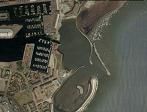
Approaching Hartlepool Marina
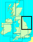
Between the Forth and the Humber virtually all the harbours described become dangerous to enter in strong onshore conditions. This is a very large section of coastline to find yourself at sea with no refuge in strong easterlies or north-easterlies.
The River Tees, although completely industrialised with no facilities whatsoever for yachts, offers your one chance for shelter... the approach is clear of danger, well buoyed, and infinitely safer to approach in strong onshore conditions than any of the others. Once inside it is another matter however... the visitor will find themselves surrounded by grim industry, wharves, docks and big ships. Craft without masts can pass further up River away from all this. Yachts however may have to root around to find somewhere to hang onto while they wait out bad weather.
There were plans afoot to yuppify Middlesbrough Docks with housing, offices etc. but it looks as though these have been shelved.
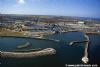
Hartlepool, laying just to the north of the River Tees, is a different matter altogether. This very large Marina has been formed from a part of the old docks, entrance is via a lock, and other than at the bottom of low water springs most pleasure vessels should be able to come and go at will.
Although not offering safe entrance in onshore gales the visitor will find absolutely all facilities available to him within, for the boat and crew.
One has to admire the sense of humour of the locals in Hartlepool in these politically correct times...
During the Napoleonic Wars, a French privateer was wrecked off the coast and the sole survivor scrabbled ashore a few days later. It was a monkey, somewhat bedraggled, but all dressed up in French uniform. The local fishermen court-martialed the unfortunate animal, and then hung him.
To this day rival football fans goad Hartlepool fans, calling them "Monkey Hangers" or "Chimp Chokers". Hartlepool United FC made their mascot H'Angus the monkey, and the locals voted a man dressed in a monkey suit, calling himself H'Angus, the Mayor of the town. His manifesto included giving free bananas to schoolkids... the Monkey Mayor won by a small majority in 2002, followed by a landslide victory in 2005 getting over 10,000 votes more than the nearest candidate... representing the local Labour Party. Grumpy politicians of non monkey persuasion were trying to get the post of Mayor of Hartlepool dropped.....LOSERS.
You couldn't make it up if you tried...brilliant !
Addendum. The post of Mayor was finally done away with in 2012 in a local referendum. Turn out? 18%
Approach
Pilotage details for yachtsmen and motorboaters planning to enter the River Tees or Hartlepool Marina:
River Tees:
If forced to take shelter within the River Tees, the entrance is pretty straightforward. Bear in mind that the port is regularly used are very large ships, bulk carriers, tankers and other levithians.
It is simply a matter of locating the Tees Approach Buoy (Red and White Vertical Stripes) position Latitude 54°40.6'N, Longitude 001°04.0'W...(Long Flash 10 sec).and following the well buoyed and absolutely straight channel and passing between the breakwaters. The larger of these is the South Gare, the smaller the North Gare. It is essential to contact Tees Harbour Radio on VHF channel 14 before entry to let them know you're coming in and to get details of shipping movements. A link to the port's website is provided below:
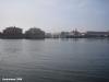
There is an area just on your port side as you enter known as "Paddy's Hole" where you may be able to anchor. There is little or no shelter in the entrance, and deeper within it is crowded with moorings leaving no room.... and the real possibility of getting tangled up should you try.
Carrying on deeper up the River will take you past numerous terminals, jetties and wharves, all in a grim industrial setting. Eventually you'll come to the transporter Bridge, with a clearance of 49 m, and soon after your way will be blocked by the Newport Bridge that no longer opens.
Possible mooring opportunities are very thin on the ground, but in the circumstances of heavy onshore weather may be preferable to being out there.
Hartlepool Marina:
The headland is easy enough to recognise and is lit by the Heugh lighthouse (Fl(2)10s). If coming from the North give the Heugh a reasonable offing to avoid rocky ledges. Hartlepool Bay shelves gently, and is clear of dangers other than the Longscar rocks to the south-east of the Marina. These are marked at their outer end by the Longscar easterly Cardinal buoy (Q(3)10s).
Very strong winds from the South East or the East can cause breaking seas in the approaches making it dangerous to consider entering.
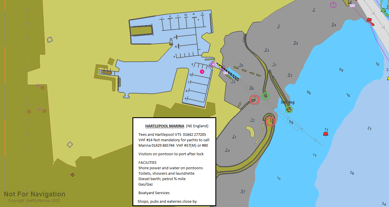
The channel into the marina is maintained at CD though they say it can vary up to half a metre dependant on weather and pressure conditions. They say that you should be able to get in HW+ 5hours but if in doubt ask for advice on #37 or #80
Following a further grounding in 2017 by a yacht which had checked with the harbour that it would be deep enough it would be wise to assume that the channel may be only dredged to CD +0.8 m in places. Navionics no longer show a dredged channel into here and does not show any depths at all!
From the Longscar easterly Cardinal buoy a generally north-westerly course will bring you towards the North and South piers forming the outer entrance to the West harbour. To the north of you you will see the buoyed and dredged channel leading to the commercial Victoria Harbour.
For the Marina pass between the stone piers and approach the lock. The Marina needs to be contacted on VHF channel 37 (M) or 80, or telephone 01429 865744. Staff are on hand 24 hours a day. A link to the Marina's website is provided below:
Most yachts will have to time their entry so that it doesn't coincide with low water, especially at Springs.
Shallow draft craft may be able to obtain access at all times, but deeper draft yachts are best to restrict themselves to 4 or 5 hours either side of high water maximum. The gates are generally kept closed LW + 1 hour to maintain the depth in the Marina.
For a night approach there is a sectored light WRG.2s, the white sector of which shows the way in at 308° T.
The lock itself is controlled by traffic signals, two red lights mean the lock is closed, one red light means a vessel is leaving the locks, and incoming boats need to wait for a green light. Should you need to wait there is a pontoon just outside the lock. Inside the lock there is a floating pontoon on your port side to tie to.
Lock Dimensions:
Width at gate 8.9 metres
Width at centre 19 metres
Length 60 metres
Depth 0.8 metres below chart datum
Berthing, Mooring & Anchoring
Locking in is required for Hartlepool Marina, details are in the section above this. The waiting pontoon showing on the UKHO chart is no longer there.
Once in take instructions from the Marina staff about where to moor your boat. There is plenty of room within the dock areas to manoeuvre and sort yourself out.
Leaving Hartlepool Marina
Prices in Hartlepool Marina were reduced years ago and now work out at (2022) £3.15 per metre per day and. these prices include electricity and water.
Up Dated Autumn 2022
Facilities
Water and electricity are available on the pontoons, toilets and showers in blocks ashore. Laundry facilities are available too. Marine toilets mustn't be used in the locked Marina. All kinds of rubbish disposal are available including waste oil and batteries. Trolleys are available for lugging heavy gear.
Security is covered by CCTV, while diesel is available 24 hours a day from the fuel berth. Calor gas and camping gas are available 24 hours a day from the lock office. Petrol is only available from the local ASDA.
Chandlery is available.
Boatyard services on-site include a 40 tonne travel-lift, and a mobile crane for masts and engines, with full boatyard facilities.
Trailer Sailor's can be catered for at the Marina, details of their website already been given.
The nearby Tees and Hartlepool Yacht Club maintains moorings at the Kafiga Landings in the commercial Victoria Harbour. These no-frills moorings are considerably cheaper than the Marina, and if you had to leave your boat for a while it might be worth seeing if you can arrange something with the club. A link to their website is provided below:
For more general information perhaps it would be best to quote directly from the tourist office:
"Hartlepool Marina is one of the most modern Marina facilities in Europe. Attracting hundreds of vessels, the £60 million Marina is Hartlepool's most alluring and relaxing location. High fashion, waterside restaurants and romantic promenades may be more characteristic of a continental port, but Hartlepool has definitely made marina life a delicacy of its own.
Modern Apartment blocks, high class restaurants, hotel, high-tech business centres, shops and entertainment venues are just some of the sights you will come across when you visit this fabulous destination."
There now you know...
Apart from the ASDA superstore (24Hrs), there are retail outlets such as TK Maxx, Next, Boots, Currys and Matalan.
Transport-wise Hartlepool is well connected, the railway station is close and offers hourly services to Newcastle and Middlesbrough. A London service runs from Sunderland nearby.
History
Hartlepool is a port in North East England.
It was founded in the 7th century AD, around the Northumbrian monastery of Hartlepool Abbey. The village grew during the Middle Ages and developed a harbour which served as the official port of the County palatine of Durham. A railway link to the South Durham coal fields in 1835 resulted in further expansion, with the establishing of the new town of West Hartlepool. Industrialisation and the establishing of a shipbuilding industry during the later part of the 19th century caused Hartlepool to be a target for the German Navy at the beginning of the First World War. A bombardment of 1150 shells on 16 December 1914 resulted in the death of 117 people. A severe decline in heavy industries and shipbuilding following the Second World War resulted in periods of high unemployment until the 1990s when major investment projects and the redevelopment of the docks area into a marina have seen a rise in the towns prospects.
History
Hartlepool was founded as a village in the 7th century AD, springing up around Hartlepool Abbey, founded in 640 on a headland overlooking a natural harbour. The monastery became famous under St Hilda, who served as its abbess from 649-657, but it fell into decline and was likely destroyed by the Vikings in 800.
During the Middle Ages the village grew into an important (though still small) town, gaining a market and walls, and its harbour was improved to serve as the official port of the County palatine of Durham.
Isambard Kingdom Brunel visited the town in December 1831 and wrote: 'A curiously isolated old fishing town - a remarkably fine race of men. Went to the top of the church tower for a view.'
Hartlepool's harbour made it a convenient outlet for the coalfields of South Durham and in 1835 a railway was built to enable South Durham coal to be exported. A rival railway was built in 1847 and docks were established at its terminus, around which a new town, West Hartlepool, was founded by Ralph Ward Jackson.
The two communities grew very rapidly, from a population of only a thousand at the start of the 19th century to 64,000 in 1891. The modern town represents a joining together of "Old Hartlepool", locally known as the "headland", and West Hartlepool. What was West Hartlepool became the larger town and the two were formally joined in 1967.
The area became heavily industrialised with an ironworks (established 1838) and shipyards in the docks (established in the 1870s). By 1913, no fewer than 43 ship-owning companies were located in the town, with responsibility for 236 ships. This made it a key target for Germany in the First World War. One of the first German offensives against Britain was the Raid on Scarborough, Hartlepool and Whitby on the morning of 16 December 1914, when units of the Imperial German Navy bombarded Hartlepool, West Hartlepool, Whitby and Scarborough. Hartlepool was hit with a total of 1150 shells, killing 117 people.
Two coastal defence batteries at Hartlepool returned fire, firing 143 shells, damaging three German ships: SMS Seydlitz, SMS Moltke and SMS Blücher. The Hartlepool engagement lasted roughly 50 minutes, and the coastal artillery defence was supported by the Royal Navy in the form of four destroyers, two light cruisers and a submarine, none of which had any significant impact on the German attackers. As a result of this bombardment, the first military casualty on British soil since the English Civil War fell, Private Theophilus Jones of the 18th Battalion Durham Light Infantry. This event is commemorated by a plaque at the spot on the Headland, and a living history group, the Hartlepool Military Heritage Memorial Society, who portray men of that unit for educational and memorial purposes.
An attempt by the German High Command to repeat the attack a month later led to the Battle of Dogger Bank on 24 January 1915 at which the Blücher was sunk. During World War II, RAF Greatham (also known as RAF West Hartlepool) was located on the current South British Steel Works.
Hartlepool suffered badly in the Great Depression of the 1930s and suffered high unemployment until the start of the Second World War, during which its shipbuilding and steel-making industries enjoyed a renaissance. Most of its output for the war effort were "Empire Ships". German bombers raided the town 43 times. After the war, both industries went into a severe decline. "Blanchland", the last ship to be constructed in Hartlepool, left the slips in 1961. There was a boost to the retail sector in 1968 when Middleton Grange Shopping Centre was opened by Princess Anne, with over 130 new shops including Marks & Spencer and Woolworths.
Before the shopping centre was opened, the old town centre was located around Lynn Street, but most of the shops and the market had moved to a new shopping centre by 1974. Most of Lynn Street had by then been demolished to make way for a new housing estate. Only the north end of the street remains, now called Lynn Street North. This is where the Hartlepool Borough Council depot was based (alongside the Focus DIY store) until it moved to the marina in August 2006. By the 1980s the area was again severely affected by unemployment. A series of major investment projects in the 1990s revived the town centre with a new marina, rehabilitation of derelict land, the indoor conversion to modernise Middleton Grange Shopping Centre from the 1960s brutalist architecture, the Historic Quay regeneration, and the construction of much new housing, which has led to the town becoming improbably chic in recent years.
Transport
Hartlepool is served by two primary routes which are the A179 road and the A689 road, both linking the town to the A19 road. The A179 road is the main road to the north west which leads to the A19 road, Durham and Tyneside. The A689 road is the main road to the south west towards the A19 & Billingham, Stockton, Middlesbrough and York. The A178 road leads south to Seaton Carew, Graythorpe, Seal Sands, Port Clarence and Middlesbrough via the Transporter bridge. The A1086 road leads north to Crimdon, Blackhall, Horden and Easington.
Rail
Trains heading to and from the north of Hartlepool run along an elevated embankment, offering an excellent view of the town.
Hartlepool is served by Hartlepool railway station which is on the Durham Coast Line with hourly services to Newcastle and Middlesbrough which are provided by Northern Rail. There is a new service to London from Sunderland provided by Grand Central that uses former InterCity 125mph trains. This is the first time in 15 years that Hartlepool has had a direct link to London by train. Seaton Carew railway station is also located on Seaton Lane
Bus
Hartlepool has services provided by Stagecoach Group around the town and to Billingham, Stockton and Middlesbrough. Other services are provided by Arriva and Go North East to Peterlee, Durham, Sunderland and Newcastle.
Sea
Hartlepool has been a major seaport virtually since it was founded, and has throughout its entire history maintained a proud fishing heritage. During the industrial revolution massive new docks were created on the southern side of the channel running below the Headland, which gave rise to the town of West Hartlepool. These docks are still in use today and still capable of handling vessels of virtually all shapes and sizes.
However, the capacity of the docks is now a fraction of what it once was, as after years of industrial downturn, a large portion of the former dockland was converted into a Superior Marina, capable of berthing 500 vessels. Hartlepool Marina is home to a wide variety of pleasure and working craft, with passage to and from the sea being determined by a lock, and visitors are always welcome to lay over and enjoy the hospitality of the town.
Hartlepool also has a permanent RNLI lifeboat station.
Tall Ships' Races
On 28 June 2006, Hartlepool celebrated after winning its bid to host The Tall Ships' Races. The town will welcome up to 125 tall ships in 2010, after being chosen by race organiser Sail Training International to be the finishing point for the race. Hartlepool will greet the ships, which will have sailed from Kristiansand in Norway on the second and final leg of the race.
The text on this HISTORY page is covered by the following licence
http://en.wikipedia.org/wiki/Wikipedia:Text_of_the_GNU_Free_Documentation_License
Eating, Drinking & Entertainment
The Mariner arriving at Hartlepool Marina will virtually find himself surrounded by things to do and places to check out.
The Maritime Experience is a recreation of 18th century seaport and gives you a good idea of what life at sea was like in Nelson's day. You can experience what life really was like aboard a real British Naval Frigate.... as the brochure says:
" ..become entranced by the world of fighting ships and hardy mariners. Turn your head to seafaring games and physical tasks. Face the daily challenges, nautical rituals and the hardship of maritime life in days gone by....."
Many of us will be well used to the daily challenges, the nautical rituals, and the hardship of maritime life on board our own yachts. Probably still worth a look though.
The development of Hartlepool Marina has caused a bit of a renaissance in the town's fortunes, not only as a place to park boats but as a tourist attraction in its own right.
Consequently Navigation Point at the Marina has become a focal point for various exotic restaurants to locate themselves. How about Chinese, Japanese, North Africa and, Spanish Tapas, Italian, and the ubiquitous Indian.
For those in a hurry there are various fast food outlets around the retail parks nearby.
Pubs and bars abound, so perhaps the best thing we can do is leave you with a couple of links for further investigation:
Pubs in the area:
http://www.beerintheevening.com/pubs/results.shtml?l=hartlepool
Restaurants:
Restaurants & Places to Eat in Hartlepool 2021 - Tripadvisor
Local Guide:
Links
|

Got a comment to make about Hartlepool ? Have you found this coverage helpful ? HAVE YOUR SAY (your email address will always be kept private)
Your Ratings & Comments
This traffic is controlled by Tees VTS on channel 14.
Kafiga Landings in the Victoria harbour is a private mooring with no space or facility for unauthorised visitors.
Kafiga Landings is controlled by the Kafiga Landings Association."
From William Todd
View all 15 feedback items