

Harbour Information (use the  icons to find out more)

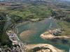

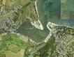
Bembridge Harbour
Your Comments: 14 Read or add your comments
Courtesy Flag
Flag, Red EnsignWaypoint
Just N of Tidegauge 50:42'.51N 001:05'.008WCharts
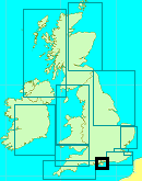
Admiralty 2022, 2037, 2045, SC5600 (links)Rules & Regulations
6 Knts Speed Limit, No Anchoring (see text)Hazards
Shallow Twisting Entrance ChannelSubmerged Barrier between Portsea and the Horse Sands Fort. Dolphins mark the safe passage.
Tidal Data Times & Range
Long Stand HW, HW approx +0014 Dover MHWS 3.1m MHWN 2.3m MLWN 0.5m MLWS 0.2m Tide tables: (links)This site is designed for slower, roaming broadband connections, like you would get at sea, so it needs JavaScript enabled to expand the text.
General Description
Contact: Harbour Office tel 01983 872828
Bembridge Harbour is a largely drying lagoon on the East coast of the Isle of Wight, bounded by sand spits on the seaward side and accessed via a twisting,dredged channel running in from abeam St Helens Fort. ... read more
Approach
Getting into Bemberidge Harbour is not difficult but will require some tidal calculations and close attention to detail... ... read more
Berthing, Mooring & Anchoring
Visiting yachtsmen or motorboaters will find the harbour authorities have established a visitors' pontoon at the Duver, where most boats will be able to remain afloat at all sides of the tide. ... read more
Your Ratings & Comments
14 comments
Recent Visit 19/6/24
Written by Tweedyreadie | 21st Jun 2024
An earlier discussion with the Harbour whilst awaiting tide to clear the bar on first visit, led to some misunderstanding and mistakenly berthing in Bembridge Marina (beyond Duver) - this is neither intended for visitors nor recommended! A thoroughly underwhelming experience mooring amongst duck sh*t and filthy shower block. The entire visit was only saved by a very good supper in Barbosa on Foreland Road, after a fair walk to Bembridge village. Had I studied VMH ahead of arrival, I would have been better informed!
1 of 1 people found this helpful
Update May 2024
Written by Bryant | 8th May 2024
Prices adjusted for 2024. Harbour has not been sold yet.
Update March 2023
Written by Don Thomson 3 | 20th Mar 2023
Top price here is now £5 per metre and shore power will cost £6 per night
Update March 2022
Written by Don Thomson 3 | 15th Mar 2022
I've reviewed this entry March 2022. Not much to add. The approach is difficult to edit as the UKHO chart of Bembridge doesn't cover the outer reaches. I've put a chart of the buoyage in the nav images and there's a link to the Bembridge website video of the approach. Navionics has a the buoyage on their charts. Prices have increased to over £4.00 per metre per night in the high season
Depth Gauge
Written by chitchat | 2nd Aug 2020
The harbour's website has the depth over the bar updated in real time. Very useful.
1 of 1 people found this helpful
Summer 2020
Written by chitchat | 2nd Aug 2020
Upgrading continues on Duver Pontoon. Authorities now adding finger pontoons which attract a higher mooring fee. £50 odd for a 37' vs £38 for the standard pontoon. Electricity included. Bookable on line or by phone. Water Taxi £2 pp each way across the harbour, and seemed to be available on demand (this was daytime). Friendly service.
The little shop in the office carries a surprisingly varied selection given its limited space.
The coastal path back from the Bembridge lifeboat station is currently closed but you can walk back along the beach.
The little shop in the office carries a surprisingly varied selection given its limited space.
The coastal path back from the Bembridge lifeboat station is currently closed but you can walk back along the beach.
UPDATE SPRING 2020
Written by Don Thomson 3 | 4th Mar 2020
No changes apart from their prices which have increased slightly since we wrote in 2018.
Access to St Helens easier than reported
Written by Conrad ryle | 19th May 2018
There is a footpath to St Helens marked on OS maps and clearly sign posted that is quicker than indicated, basically bear right and then head north rather than take the causeway path, and then take a footbridge over a little creek, no need to go anywhere near the bay watch Cafe on the beach. A pleasant climb through woods will take you to the beginning of the village. Soon you will be at the large village green with the pub, looks good, but not eaten there, Bembridge crab' on the menu, and also a shop which has fresh veg,local pies and general provisions. From there you can walk to Brading, mainly off road.
UPDATE SPRING 2018
Written by Don Thomson | 12th Mar 2018
Not much to change here. Prices have gone up very slightly and the garage has close. The charts have been updated.
Small update
Written by Dolomede | 6th Jul 2014
The large petrol station in Bembridge village mentioned above is no longer. (It's former site is fast becoming desirable dwellings.) Also, the village itself is full of interesting and useful shops but up a fair hill from the harbour.
2 of 2 people found this helpful
View all 14 feedback items

© visitMyHarbour.com | website design created by Black Culm Ltd