

Harbour Information (use the  icons to find out more)

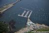
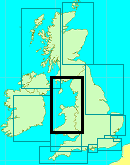
Holyhead Harbour
Your Comments: 13 Read or add your comments
Courtesy Flag
Flag, Red EnsignWaypoint
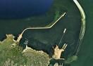
Breakwater End 53:19'.87 N 004:37'.13 WCharts
Admiralty 2011, 1413Rules & Regulations
UnknownHazards
TSS in Entrance, Ferries inc HHSTidal Data Times & Range
HW = Dover -0040 MHWS 5.2m, MHWN 4.4m, MLWN 2.0m, MLWS 0.7m (links)This site is designed for slower, roaming broadband connections, like you would get at sea, so it needs JavaScript enabled to expand the text.
General Description
Contacts
Marina tel 01407 764242 VHF #37 (M)
Sailing Club tel 01407 762526 VHF #37 (M) c/s "Club Launch" ... read more
Approach
Any kind of approach from the North will find the small craft mariner..... ... read more
Berthing, Mooring & Anchoring
Mooring options include anchoring, Holyhead Sailing Club moorings, or on what is left of the Holyhead Marina. ... read more
Your Ratings & Comments
13 comments
Update April 2026
Written by Chris99 | 30th Apr 2026
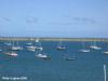
We arrived late at night in a storm and initially picked up a mooring on the right-hand side, close to the harbour wall and well inside the harbour. We assumed this was a club mooring, but it turned out that the club moorings are actually located nearer the centre of the mooring field, approximately 250 yards south of the wall. We moved to the correct area the following morning.
Mooring charges are currently:
Up to 30 ft: £22.50 per night
30 to 39 ft: £28.50 per night
40 to 48 ft: £34.00 per night
49 to 60 ft: £44.50 per night
The club launch operates on VHF channel 37 (M1). I had a new VHF set and needed to enable private channels to access this. Payment for the mooring is made directly to the launch helm. The leaflet states that both cash and card are accepted, although I paid in cash.
The launch runs from 9am to at least 7pm, with later service at weekends. Full details are available on the club’s website.
The club itself is excellent, serving good beer, with food available in the upstairs café/restaurant. The café is closed on Mondays and Tuesdays, and closes at 9pm on other days, or 4pm on Sundays.
The harbour is very well sheltered in most conditions, with the exception of an extreme north-easterly. The club moorings are well maintained.
There is a train station approximately a five-minute taxi ride away.
Passage notes
We entered the harbour at night in strong winds after coming south through the TSS from the Isle of Man. The difficult crossing cost us several hours and resulted in our arrival against the ebb tide. However, conditions eased as we approached the harbour entrance. Rounding the Skerries was particularly difficult, with adverse conditions reducing our speed to around 1 knot for approximately three hours.
A few days later, we departed about one hour before slack water at South Stack. Despite this timing, there were significant overfalls at the harbour entrance. The wind was north-westerly at approximately Force 5.
The sea state was very confused, and a smaller vessel would likely have struggled. These conditions followed several days of strong winds in the Irish Sea. After standing off 5 to 6 miles, conditions moderated to a more typical sea state.
1 of 1 people found this helpful
Update May 2024
Written by Bryant | 23rd May 2024
Thanks to Paul Bond of the Sailing Club. His notes have been worked into the coverage, the main gist of it is below:
"I have attached some notes including changes that I think will be of most use to visiting yachts.
The main update is probably that whilst the “Marina” pontoon is still in limited use, that Holyhead sailing club have laid a number of dedicated visitors moorings.
As noted in the attachment the major Marina Development in the Harbour has still not commenced,"
UPDATE SEPTEMBER 2022
Written by Don Thomson 3 | 13th Sep 2022
I reviewed these notes in September 2022. Gloom; it looks as though the marinas may not be replaced in the near future. This will draw a lot of North bound skippers to the Irish side from Milford - especially with the favourable tidal streams from Dublin to Belfast.
UPDATE SUMMER 2021
Written by Don Thomson 3 | 4th Aug 2021
I reviewed these notes in August 2021. The references to the Marina have been edited to reflect the reduced state of the pontoons. The Yacht Club is taking up some of the slack but at the moment the Marina Landing Stage is managing with all their amenities as usual. I've added a paragraph on the Marina plans.
1 of 1 people found this helpful
Holyhead
Written by Rudders | 10th May 2021
Good safe haven with basic offering . Hot welcome shower, laundry. Coffee and town for all your supplies.Good chandlery. (Closed Sunday) .Habour office closed Saturday and Sunday.Sound like promise of infrastructure improvements. But watch this space . We approached from the south. Good offing to the overall standard stuff going north about south and north stacks . However tidal info not that clear for Bardesy sound ! Stayed in Aberdaron bay (lovely spot)wanted to arrive Holyhead in day light . We did and pls so as a few submerged bouys on way to dock. Would not want to rely on fuel or gas. Water and power on short pontoon by white bridge.
Marina Update
Written by Ralph | 9th Mar 2020
Despite the marina owner's best efforts, there is still only a single pontoon (Breakwater 1), connected to land by a bridge.
Services ashore are still available, but office hours have been curtailed in light of the loss of berthing. It is still worth phoning if you are planning a trip to Holyhead (01407 764242) and Holyhead Sailing Club continues to be accommodating (01407 752526) with Visitors' moorings and a launch service during the season.
Services ashore are still available, but office hours have been curtailed in light of the loss of berthing. It is still worth phoning if you are planning a trip to Holyhead (01407 764242) and Holyhead Sailing Club continues to be accommodating (01407 752526) with Visitors' moorings and a launch service during the season.
1 of 1 people found this helpful
FURTHER UPDATE SPRING 2018
Written by Don Thomson | 29th May 2018
We have been reminded that Holyhead Sailing Club still has facilities for visiting boats and can provide visitors moorings as usual with a water taxi service. A point worth remembering if you do not need marina facilities in the future. At the moment you need to check availability in advance.
UPDATE SPRING 2018
Written by Don Thomson | 17th Apr 2018
NEW 2018. There was horrendous damage here during March 2018. As far as we know the marina was pretty-well wrecked and we have no details of the plans for renewal of facilities. If you intend stopping here we advise you contact them well in advance to check on what is available (Though it is hoped that they will have the visitors pontoon up and running by June - albeit with reduced services).
2 of 2 people found this helpful
UPDATE APRIL 2017
Written by Don Thomson | 19th Apr 2017
I reviewed these notes in April 2017 (not before time either!) I've got the new prices in for this season, added a downloadable harbour plan and updated the charts.
1 of 1 people found this helpful
Change to Holyhead Sailing Club Website details
Written by FikkiMinn | 29th Jan 2017
The Club Website is on the following link: www.holyheadsailingclub.co.uk. The club launch runs April through October with varying times. All details are on the visitor information tab.
Our facebook page is www.facebook.com/hhsailingclub/
Our facebook page is www.facebook.com/hhsailingclub/
1 of 1 people found this helpful
View all 13 feedback items

© visitMyHarbour.com | website design created by Black Culm Ltd