You are viewing the expanded version of this Harbour,
for faster browsing
use the regular version here

Holyhead Harbour
Courtesy Flag
Flag, Red EnsignWaypoint
Breakwater End 53:19'.87 N 004:37'.13 WCharts
Admiralty 2011, 1413Rules & Regulations
UnknownHazards
TSS in Entrance, Ferries inc HHSTidal Data Times & Range
HW = Dover -0040 MHWS 5.2m, MHWN 4.4m, MLWN 2.0m, MLWS 0.7m (links)This site is designed for slower, roaming broadband connections, like you would get at sea, so it needs JavaScript enabled to expand the text.
General Description
Contacts
Marina tel 01407 764242 VHF #37 (M)
Sailing Club tel 01407 762526 VHF #37 (M) c/s "Club Launch"
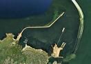
Holyhead is an absolutely huge harbour, and provides an excellent port of refuge in virtually all conditions. It is strategically placed for those planning to hop across the Irish Sea. The breakwater that protects the New Harbour was completed in 1873, and encloses a large area of sheltered water. Various ferries and fast cats regularly use Holyhead, connecting with Dublin in Ireland. Ferry activity is kept to a completely different side of the port, and apart from sharing the entrance approaches the yachtsman or motorboater should have no problems. Berthing within the harbour always used to be on mooring buoys provided by the hospitable Holyhead Sailing Club, or swinging to your own gear. This is still an option, but in strong winds with a North or north-east component, the sheer size of the harbour can allow a loppy sea to develop.
Holyhead Port is operated by Stena Ports Ltd. It is now one of the UK`s busiest ferry ports with over 3000 ferry movements per annum. These comprise of large conventional ferries and High Speed catamaran vessels. Additionally there is an average of 2 Cruise Liner visits per week.
The ferry berthing and cruise liner berth is to the east of the port away from the leisure craft berthing and moorings.
There is a TSS in the entrance which must be avoided during commercial vessel movements. It is recommended to monitor Holyhead Port Radio on VHF 14 there may be occasions when one of the larger Cruise Liners may be at anchor to the east of the harbour wall.
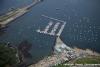
The remaining concrete single pontoon of the Marina has approx. 200 linear metres of berthing, which may also be occupied by commercial vessels. The pontoon has widely spaced mooring cleats and caution should be used when there is winds from an easterly quadrant. Water and electricity are available on the pontoon. Fuel is only available in Holyhead town. The detached concrete pontoons adjacent to the marina are not in use.
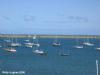
Holyhead Sailing Club has provided 10 dedicated visitors moorings situated on the NE corner of the Club Moorings. (Ie. the first ones to be approached from the Harbour entrance) These Moorings consist of yellow or orange “Hippo” type buoys with a floating strop attached. A blue pickup buoy is attached to the strop, marked with a V. The Club provides a launch service to these moorings which can be called on VHF 37.Holyhead Sailing Club Website gives Visitor rates for vessels up to 48 Ft Loa
Anchoring is not permitted in the marked “fairway” area of the outer harbour.
Holding is reported by the Harbour Master to be poor in places.
Approach
Any kind of approach from the North will find the small craft mariner.....
...... having to contend with Carmel Head and the Skerries.
To seawards of Carmel Head is an extensive area of rocky shoals, shallow patches, tidal races, overfalls and other dangers that no right minded small craft Mariner would want to involve himself in. The Skerries is the outlying stack of rocks and these are well marked by The Skerries Lighthouse (Fl(2)10s.36m.20m). This Lighthouse also displays Iso.R.4s.26m.10M in such a way that this light covers the dangerous shoals to the north-east of it.
More pilotage directions:
An inshore passage between Carmel Head and the Skerries does exist and is used at slack water by experienced locals. It is not proposed to describe it here. Suffice to say that any wind against tide situation (with the tide capable of reaching 6 kn), will cause very confused seas, which can rapidly degenerate into breaking seas should wind increase.
This leaves the other option to pass outside the whole lot, and give The Skerries a good offing of at least a mile. In unsettled conditions a clearance of about 2.5 miles would be better. The tide here runs South West from +0030 Dover, and turns north east at -0550 Dover. It must be borne in mind however that a traffic separation zone guides shipping around this area, and you risk straying into the oncoming lane should you keep too far off the Skerries. All is clear on the chart.
Once past the Skerries a turn southwards can be made, and after leaving Langdon Ridge and its associated westerly cardinal buoy (Q(9)15s) on your port side, a course shaped up for the harbour entrance.
If approaching from the South or South West a good offing needs to be given to the Holyhead Race which lies up to 2 miles off The Stacks. The South going tidal flow begins at -0030 Dover, while the North going flow commences at +0530 Dover. These streams can reach 5 kn during spring tides close to South Stack, with strong wind against tide conditions producing dangerous breaking seas. In general the heavier the weather, the greater the offing should be, as the effects of the tidal race can be felt several miles off. For more information see the note made in 2011 in the comments at the bottom.
Some thoughts on “Approach”.
The key to approaching Holyhead Bay is to get the tides right especially on anything approaching springs. From the east, the inshore route across the top of Anglesey is the safest the only issues are not being at Carmel head on the max state of the ebb and condition of strong wind against tide.
From the South there is an area to the west of south Stack. Designated “Tidal Energy Demonstration Zone” Currently this has a surface marker approx. 2.9 Nm west of South Stack LH. Which may have a guard vessel on station. (Currently, there are no other surface obstructions present in the zone)
In the closer approaches, entry to the harbour is made between the end of the breakwater (Fl(3)G.10s.21m.14M) and a red can buoy Clipera (Fl(4)R.15s) which unfortunately is just off the edge of our harbour chart.
A traffic separation zone has been established in the harbour mouth which can be seen partly on the chart provided. Incoming traffic keeps closer to the breakwater (driving on the right), outgoing traffic keeps well clear of the breakwater and closer to the above-mentioned red Clipera Buoy.
The harbour authorities "Holyhead Harbour" work on VHF channel 14, with the initial call on 16. Be prepared for ferry traffic including fast cats, and keep a weather eye behind you as well. If in the slightest doubt call Holyhead harbour before entering the small TSS in the entrance.
Give the breakwater a good clearance as you enter, then swing to starboard taking note of the green conical Spit buoy (Fl.G.3s) which marks shallows radiating southwards from the breakwater end. This must be left on your starboard side as you proceed into the harbour.
Follow the line of the breakwater at a reasonable offing following it as it bends round to the West. Once the small craft moorings off the beach and yacht club are bearing due South you can turn to port and make your way towards them. A quick glance at the larger scale chart will show the fairway areas where anchoring is not allowed. The approach within the harbour outlined above keeps the small craft Mariner well clear of the Outer Platters shallow patches and their associated buoyage.
The visitor then has the choice of using the Marina, the moorings provided by the yacht club (with launch service), or even the possibility of anchoring.
The harbour is well lit for night entry but the East shore of the Outer Harbour (Twyn Cliperau) is a long line of sodium street lights so it can be difficult picking a point to assess ones drift against the pierhead light. (That you are drifting will be emminently obvious as the far shore will be speeding past the light like an old black & white movie panorama shot!) The other problem after that is the number of moored boats (including the Life boat) which do not carry lights - one of those multi candle powered hand held search lights can be a boon but have it ready in the cockpit (by the time I found mine I was almost aboard the lifeboat!!) From memory the long North breakwater doesn't carry street lights so it is difficult to navigate close to it in the dark. Just be aware that once you have rounded the pierhead you can't breath a sigh of relief and relax - there's still a lot to do. Tom Webb in his comments at the bottom of the page had similar problems with night entry as well as a horrendous encounter with the rips around the Skerries.
Berthing, Mooring & Anchoring
Mooring options include anchoring, Holyhead Sailing Club moorings, or on what is left of the Holyhead Marina.
Full details are now provided including visitors prices.
If intending to use the swinging moorings provided by Holyhead Sailing Club call the "Club Launch" on VHF channel 37 (M1) as you're approaching. The club moorings are off the beach in front of the club premises and adjacent to the Marina landing stage. The normal hours for this service are 9 AM to 9 PM, and 11 PM on Fridays and Saturdays.
The launch will meet you and guide you to a mooring. If the launch doesn't respond for any reason pick up an empty mooring, make a note of its number and wait for assistance.
The boat man will hand you some information about the club and work out to your mooring fees depending on how many nights you are staying. £22 per night for a 30' boat. The fee also covers use of the launch service, temporary membership of the club for the crew including showers toilets etc, plus access to the bar and restaurant when available. Temporary members need to be signed into the visitors book.
If you are staying at the Marina you are still welcome to use the club and its facilities. A link to the club's website is provided below, where you will also find visitors mooring prices:
http://www.holyheadsailingclub.co.uk/
It is possible to anchor within this harbour clear of the yacht club moorings and the fairway as shown on the chart. This may be an option if you have a very large boat that is too heavy for the club moorings and don't want to fork out for a marina berth... it would be wise to keep the boat attended at all times.
The Marina

Holyhead Marina was in the Western corner of this harbour and had plenty of room for visitors. At the moment they have 100 metres of landing stage and they can raft you up to that if necessary. All the usual Marina facilities are available here and more, and prices on the landing stage work out at £3.10 per metre per night (min 7m) with departure at noon the following day. Short-stays are charged at £10. Interestingly this Marina works its charges out based on your exact length, with fractions of a metre charged pro rata. That price includes VAT, and showers (the laundrette is coin op)
A link to the Marina's website is provided below:
http://www.holyheadmarina.co.uk/
To arrange your berth, call "Holyhead Marina" on Ch 37 (M) in the approach. Either a berth will be allocated, or if you don't get a reply secure to the landing stage
After getting tied up visit the office to complete the paperwork.
Facilities
If on the club moorings water is available by Jerry can from the club. If berthed in the Marina water and electricity are available on the pontoons, with toilets, showers and laundry ashore. Security is handled by 24-hour CCTV with code controlled gates.
Free WiFi at the Marina Office is available, together with Internet access at the office.
No longer any fuel available in the harbour. Fuel has to be obtained in cans from the town (see our note below reference a cab ride - makes petrol expensive here!)
An on site Chandlers sells bottled gas (including Camping Gaz 907s) amongst other things, and there's even a Marina grocery store opening the hours mentioned above which carries a reasonable stock of provisions.
Full boatyard facilities are available here covering all kinds of hull constructions together with specialists for inboard and outboard engines, stainless steel welding, and rigging.
If the Marina store can't supply your needs for provisioning you have to take a cab to any of the large supermarkets on the outskirts of town. These include a Tescos and Morrison's. The town itself isn't so far, but still a short cab ride. Here you will find a reasonable range of shops and banks etc.
For crew changes, Holyhead is well served being the terminus of the North Wales Coast Line and is served by Virgin Trains (intercity) and Arriva Trains Wales services. Fast connections to Dublin (well under two hours) are available via the Dublin Swift HSS ferries. The ferry service to Dun Laoghaire has been discontinued.
Trailer Sailors can launch into Holyhead harbour from the ramp belonging to Holyhead Sailing Club. This gives access a half the tidal range with a charge of £10 for non-members. Water-skiing is permitted offshore, but speed limits are enforced within the harbour.
History
Holyhead is the largest town in the county of Anglesey in the north west of Wales.
Although it is the largest town in the county, with a population of 11,237 (2001 census), it is neither the county town nor actually on the island of Anglesey. Instead, it is located on Holy Island which is connected to Anglesey by Four Mile Bridge, so called because it is four miles (6 km) from Holyhead on the old post road from London, and a causeway (known locally as "the cob") built by local philanthropist Lord Stanley in the 19th century. The causeway now carries the A5/A55 road and the railway line to Chester, Crewe and London.
The town centre is built around St. Cybi's Church, which is built inside one of Europe's only three-walled Roman forts (the fourth wall being the sea, which used to come up to the fort). The Romans also built a watchtower on the top of Holyhead Mountain inside Mynydd y Twr, a prehistoric hillfort. Settlements in the area date from prehistoric times, with circular huts, burial chambers and standing stones featuring in the highest concentration in Britain. The current lighthouse is on South Stack on the other side of Holyhead Mountain and is open to the public. The area is also popular with birdwatchers.
Transport
Holyhead has a busy ferry port handling more than 2 million passengers each year. Stena Line, Europe's biggest ferry company, operates from the port as do Irish Ferries. Ferries sail to Dublin and Dún Laoghaire in Ireland and this forms the principal link for surface transport from central and northern England and Wales to Ireland. There is archaeological evidence that people have been sailing between Holyhead and Ireland for 4,000 years. Holyhead's maritime importance was at its height in the 19th century when the two and a half mile (4 km) breakwater, widely acknowledged to be one of Britain's finest, was built, creating a safe harbour for vessels caught in stormy waters on their way to Liverpool and the industrial ports of Lancashire. Holyhead's sea heritage is remembered in a maritime museum.
With the opening of the railway from London to Liverpool, Holyhead lost the London to Dublin Mail contract in 1839 to the Port of Liverpool. Only after the completion of the Chester and Holyhead Railway in 1850 and the building of Holyhead railway station did the Irish Mail return to Holyhead. Holyhead is currently the terminus of the North Wales Coast Line and is served by Virgin Trains and Arriva Trains Wales services.
The text on this HISTORY page is covered by the following licence
http://en.wikipedia.org/wiki/Wikipedia:Text_of_the_GNU_Free_Documentation_License
Eating, Drinking & Entertainment
Holyhead Sailing Club, already mentioned, makes visitors welcome at its premises next door to the Marina. It has a nice bar and restaurant that overlooks the moorings.
Also near by is the Boathouse Hotel, and The Bistro.
If none of these suit it will mean a short cab ride to Holyhead Town Centre, where you will find a large range of pubs, together with eating houses ranging from MacDonalds, thru Fish and Chips to Indian and Chinese. Try the links below:
Pubs
http://www.beerintheevening.com/pubs/results.shtml/el/Holyhead%3BGwynedd/
Restaurants
Links
|

Got a comment to make about Holyhead Harbour ? Have you found this coverage helpful ? HAVE YOUR SAY (your email address will always be kept private)
Your Ratings & Comments
Mooring charges are currently:
Up to 30 ft: £22.50 per night
30 to 39 ft: £28.50 per night
40 to 48 ft: £34.00 per night
49 to 60 ft: £44.50 per night
The club launch operates on VHF channel 37 (M1). I had a new VHF set and needed to enable private channels to access this. Payment for the mooring is made directly to the launch helm. The leaflet states that both cash and card are accepted, although I paid in cash.
The launch runs from 9am to at least 7pm, with later service at weekends. Full details are available on the club’s website.
The club itself is excellent, serving good beer, with food available in the upstairs café/restaurant. The café is closed on Mondays and Tuesdays, and closes at 9pm on other days, or 4pm on Sundays.
The harbour is very well sheltered in most conditions, with the exception of an extreme north-easterly. The club moorings are well maintained.
There is a train station approximately a five-minute taxi ride away.
Passage notes
We entered the harbour at night in strong winds after coming south through the TSS from the Isle of Man. The difficult crossing cost us several hours and resulted in our arrival against the ebb tide. However, conditions eased as we approached the harbour entrance. Rounding the Skerries was particularly difficult, with adverse conditions reducing our speed to around 1 knot for approximately three hours.
A few days later, we departed about one hour before slack water at South Stack. Despite this timing, there were significant overfalls at the harbour entrance. The wind was north-westerly at approximately Force 5.
The sea state was very confused, and a smaller vessel would likely have struggled. These conditions followed several days of strong winds in the Irish Sea. After standing off 5 to 6 miles, conditions moderated to a more typical sea state.
"I have attached some notes including changes that I think will be of most use to visiting yachts.
The main update is probably that whilst the “Marina” pontoon is still in limited use, that Holyhead sailing club have laid a number of dedicated visitors moorings.
As noted in the attachment the major Marina Development in the Harbour has still not commenced,"
Services ashore are still available, but office hours have been curtailed in light of the loss of berthing. It is still worth phoning if you are planning a trip to Holyhead (01407 764242) and Holyhead Sailing Club continues to be accommodating (01407 752526) with Visitors' moorings and a launch service during the season.
Our facebook page is www.facebook.com/hhsailingclub/
View all 13 feedback items