

Marina Information (use the  icons to find out more)


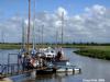
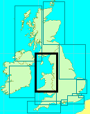
Preston, Docks, Marina, River Ribble and River Asland (or Douglas)
Your Comments: 5 Read or add your comments
Courtesy Flag
Flag, Red EnsignWaypoint
Safewater BuoyCharts
Admiralty 1981Rules & Regulations
UnknownHazards
Approach Dries, Much is unmarked, Dangerous in Strong Onshore ConditionsTidal Data Times & Range
HW = Dover +0025 MHWS 5.3m, MHWN 3.3m, MLWN 0.1m, MLWS 0.1mThis site is designed for slower, roaming broadband connections, like you would get at sea, so it needs JavaScript enabled to expand the text.
General Description
Preston's industrial past was heavily based on textiles, a trade that fell into terminal decline from the mid 20th century. ... read more
Approach
The original channel led out to sea, confined by training walls that caused the tides to scour it. ... read more
Berthing, Mooring & Anchoring
Preston Marina works on VHF channel 80 (M), call them for berthing instructions. ... read more
Your Ratings & Comments
5 comments
UPDATE SEPTEMBER 2022
Written by Don Thomson 3 | 16th Sep 2022
I reviewed these notes in September 2022. Since they first started to rejuvenate this bit of Preston Docks the area has become quite attractive and very different to the wind-swept wilderness they started off with. There's plenty to do and see here and the visiting yacht prices are very reasonable.
UPDATE SUMMER 2021
Written by Don Thomson 3 | 16th Aug 2021
I reviewed these notes in August 2021. No changes
UPDATE SPRING 2018
Written by Don Thomson | 19th Apr 2018
There have been a couple of additions to their services - Gas/Gaz; pump-out and a petrol delivery service. Their charges have gone up but still very cheap.
Update Spring 2016
Written by dononshytalk | 14th Apr 2016
These notes were reviewed by Don in April 2016. Prices have changed and they are only £10.00 per night per boat.
NB> There are references on their website to "HW Liverpool" (on charts and in the text); this is from the Laver tidetables not the UKHO.
NB> There are references on their website to "HW Liverpool" (on charts and in the text); this is from the Laver tidetables not the UKHO.
Update 2013
Written by dononshytalk | 25th Feb 2013
These notes were reviewed by Don T on the 21st February 2013. We checked with the marina who have confirmed that the passage between the training walls is still clear and that the old South Gut has fallen into disuse. The tariff here is now the 2013 one.
3 of 3 people found this helpful


© visitMyHarbour.com | website design created by Black Culm Ltd