You are viewing the expanded version of this Marina,
for faster browsing
use the regular version here

Preston, Docks, Marina, River Ribble and River Asland (or Douglas)
Courtesy Flag
Flag, Red EnsignWaypoint
Safewater BuoyCharts
Admiralty 1981Rules & Regulations
UnknownHazards
Approach Dries, Much is unmarked, Dangerous in Strong Onshore ConditionsTidal Data Times & Range
HW = Dover +0025 MHWS 5.3m, MHWN 3.3m, MLWN 0.1m, MLWS 0.1mThis site is designed for slower, roaming broadband connections, like you would get at sea, so it needs JavaScript enabled to expand the text.
General Description
Preston's industrial past was heavily based on textiles, a trade that fell into terminal decline from the mid 20th century.
It has faced the same challenges as many other post industrial northern towns.The port, once important and prosperous, declined and was finally closed to commercial traffic in 1981. The channel leading out to sea which runs between training banks had also suffered. Important news:
As of Spring 2010 the original channel between the training walls has cleared itself and is now the recommended route into Preston. See Approach and Entry section.
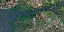
The approach to Preston from the sea involves tackling the Ribble Estuary, and then making your way another 10 miles odd up the marked channel. Entry to the lock at Preston is possible from 1hour before to 2 hours after HW Liverpool
Although possibly a bit tricky (and not be attempted in strong onshore conditions) there are leading marks to help, and you will be berthed right in the city, at a very reasonable cost too.
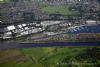
Development of the docks and surrounding areas known as Riverside is helping the rejuvenation of the city with housing, restaurants and cinema. The Marina is formed in the old Albert Edward Dock and offers up to 350 berths (with plenty of room for expansion by the looks of it).
There are another couple of boatyards in the area, one which can offer moorings too.
Approach
The original channel led out to sea, confined by training walls that caused the tides to scour it.
A quick glance at the chart will show that the red-and-white Gut buoy (LFl.10s) was placed to aid entry into this Channel. This buoy is still the starting point to negotiate the Ribble Estuary. Until 2010 the outer part of the original channel had completely silted up, and also had a charted wreck within that dried to over 6 m. It could not be used; but this has all changed.
Pilotage Directions to Preston Marina and Douglas Boatyard..
Leave the Gut Buoy at 2 hours before High Water and head in an East North Easterly direction to leave the 3 starboard hand perches approx 3 or 4 boat-lengths to starboard and then continue upstream between the perches. Watch out for the zig zag as you approach the Lytham Windmill as the straightaway leads into the Lytham moorings, guarded by two red perches.
The unmarked South Gut channel, which had been the recommended approach until 2010 is still there of course, and may still be advantageous to those with local knowledge approaching from the South but is not recommended for visiting yachts so we have removed all our previous guidance for this route
Once within the remainder of the channel you will find it is marked by many lit and unlit perches and beacons mounted on the training walls themselves. These walls are submerged by half tide so you will not see them, and it is essential you do not stray.
On the Estuary chart in our gallery you may notice four unattached green "blobs"; closer examination in better definition show these to be birds as this estuary is an important bird sanctuary.
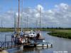
At the 5 mile mark the River Asland (or Douglas), branches off to starboard. Douglas Boatyard (01772 812462) will be found a couple of miles up the River, and it's accessible a couple of hours either side of high water. They have drying and floating berths, as well as full boatyard facilities. A link is provided below:
http://www.douglas-marine.co.uk/
If heading for Preston Marina continue up the Ribble, and in the closer approaches call Riversway on VHF channel 16 (working channel 14) for information about lock operations.. The lock is normally open for 1 hour before HW Liverpool to 2 Hours after HW Liverpool but only during the hours between 7 AM and 8 PM during the summer. Between 1st October and 31st March a Lockmaster will be made available to provide locking, as above, upon 24hour notice of request made to the marina operator (Preston Marine Services tel: 01772 733595 mob 07919 406636)
NB When the marina or lock gates quote "HW Liverpool" they are referring to the Laver tide tables not the UKHO and they can be up to 30 minutes different. The Liverpool times for the day can be found on the "Lock Operating times" tab on the Preston Marina website (Link below)
There is enough water in the entry chamber to the West of the lock/cill system for you to wait for them if necessary. There are large red fenders either side of the ladder on the starboard side and the bottom is very soft mud. Note there are 2 locks and a swing bridge to negotiate.
Once through the first set of opposing gates at the entrance and into the big basin (presumably the cill/gate set up at the entrance is to prevent spring tides getting in at high tide and then the basin water getting out at low tide) you will probably be processed straight through the boom and lower lock gate into the lock chamber. If there is a delay do not go swanning about in that boom basin because it's heavily silted on the north (port) side. Basically it's a slick operation and you'll probably lock up to find the swing bridge has already been swung and you can go ahead into the Marina.
Berthing, Mooring & Anchoring
Preston Marina works on VHF channel 80 (M), call them for berthing instructions.
Alternatively telephone them on 01772 733595. Opening Hours: 1000am to 1700 seven days a week.

Once through the locks and swing Bridge the Marina lies immediately on your port side. A link to their website is provided below:
http://www.prestonmarina.co.uk/
Their daily mooring rates of £15.00 per boat per night are extremely reasonable, especially when you consider that it includes electricity.
They have found that once a yacht has visited them for a first time they turn into regulars.
Facilities
Facilities include water and electricity on the pontoons, toilets and showers ashore. Diesel is available as is pump-out. The petrol delivery service,has been discontinued
The Marina has a boatyard with crane and storage facilities but no engineering services. There is also an on-site chandlery and clothing shop. Training courses are also run from here.
The Marina is sited reasonably centrally for the city and its attractions. The main centre is a little over a mile away, with a frequent bus connection from the dock area.
The Riversway developments around the dock offers a cinema, health club and go-karting amongst other things.
The nearest supermarket is Morrison's at the far end of Albert Edward Dock is easily walkable. For more generalised shopping in the city centre, the Fishergate Shopping Centre has a Primark, TK Maxx, Argos and T.J. Hughes stores. The Mall (formerly St. George's) is another popular centrally located shopping mall dating from the 1960s.
The Miller Arcade is a specialist shopping centre in a listed building, which formerly included public baths, situated next to the Harris Museum.
Preston's main high streets are Fishergate and Friargate which offer shops, bars and restaurants with many more tucked away down the side streets.
Transport wise, Preston Railway Station is a major stop on the West Coast Main Line, with regular long distance train services to London (Euston) and the South East, and Glasgow and Edinburgh to the North. Preston is also a hub for connecting rail services in the North West. It's a short cab or bus ride from the Marina.
For access by car, the M6 passes close by Preston.
History
Preston is a city and non-metropolitan district of Lancashire, in North West England. It is located on the north bank of the River Ribble, and was granted city status in 2002, becoming England's 50th city in the 50th year of Queen Elizabeth II's reign.
Textiles have been produced in Preston since the middle of the 13th century, when locally produced wool was woven in people's houses. Flemish weavers who settled in the area during the 14th century helped to develop the industry. Sir Richard Arkwright, inventor of the spinning frame, was a weaver born in Preston. The most rapid period of growth and development in Preston's history coincided with the industrialisation and expansion of textile manufacturing. Preston was a boomtown of the Industrial Revolution, becoming a densely populated engineering centre, with large industrial plants.
The former Preston Port, known as Riversway or The Docks, has been the site of an expanding commercial and residential complex since 1988.
The Marina is just north of the River Ribble which enters into the east of the Irish Sea. This marina has its own chandlery and coffee shop, training courses and boat sales
There are multi-million pound plans to redevelop Preston's Docks (as well as large sections of the River Ribble running through the city) to introduce leisure facilities (ie watersports), new landmark buildings, a new central park opposite Avenham Park, office and retail space, new residential developments and the re-opening of some of Preston's old canals. However, these plans, collectively known as Riverworks, have yet to undergo public consultation, and have already raised concerns amongst locals due to the potential loss of green space and increased risk of flooding.
The text on this HISTORY page is covered by the following licence
http://en.wikipedia.org/wiki/Wikipedia:Text_of_the_GNU_Free_Documentation_License
Eating, Drinking & Entertainment
If you are based in the Marina you will find several pub/restaurants within the Riversway development, including The Waterfront, Chiquito and The Ribble Pilot.
Otherwise hop a bus to the city centre where the choice will be nigh on unlimited. A couple of links are provided below for further investigation:
Pubs
http://www.beerintheevening.com/pubs/results.shtml/el/Preston%3BLancashire/
Restaurants
Links
|

Your Ratings & Comments
NB> There are references on their website to "HW Liverpool" (on charts and in the text); this is from the Laver tidetables not the UKHO.