 Dartmouth Harbour and River Dart
At a Glance
Download Guide
For many approaching from the Solent or from Poole, Dartmouth will...
...... be the first port of call in the West Country. In many ways it gives a taste of what is to come with steep to shoreline, plenty of deep water and interesting historic towns. The Royal Naval College overlooks the harbour, and often warships visit with much activity in the immediate area.
The harbour is extremely attractive, well sheltered and easy to enter. Day or night at any state of the tide, and in nearly any weather conditions Dartmouth is safe to enter, and is well worthy of the title " harbour of refuge". There is plenty of room to accommodate super yachts and heavyweight levithians, whilst shallower draft craft can make their way up the River Dart as far as Totnes.
The whole of the River Dart as far as Totnes is under the control of the Dart Harbour and Navigation Authority, and first-time visitors to the West Country may be surprised to find that wherever they go and whatever they do within this fiefdom comes with a charge. Harbour dues are payable at 90p per metre for every day you remain anywhere within, but in actual practice it is included in the price of the harbour authority moorings, and the prices are not unreasonable. Vessels at anchor are charged the daily harbour dues, and marinas tend to add it to their price as an extra....
The mooring options include anchoring, mooring to a visitors buoy, mooring to an isolated visitors pontoon, possible use of a walk ashore pontoon (generally busy), three marinas one of which is quite expensive, or pushing up the River to the village of Dittisham or beyond where there are anchoring and mooring possibilities.
There are several boatyards including quite a large haul out facility at Galmpton, and enough chandlery and technical expertise to cover most eventualities.
Dartmouth Harbour and River Dart
Approach
From seaward the entrance to Dartmouth is not obvious until much closer in.
There is a very conspicuous daymark on the Hill to the East of
the entrance, a drawing of which is on the chart. It stands 24 m
tall on the 170 m hill, and is easy to pick out. The Mewstone Rock
lying off Outer Froward point can easily be picked out when
approaching from the West, but perhaps it's not so easy to
see when you are approaching from the South.
When approaching from the East keep a good offing to clear the
Eastern Blackstone, and The Mewstone (marked by the "Mewstone"
southerly Cardinal buoy (VQ(6)+LFl.10s)). Further dangers run
parallel to the shore...The Cat Stone and The Verticals, and these
are marked by another southerly Cardinal buoy "West Rock"
(Q(6)+LFl.15s). These dangers and their associated buoyage need to
be left well to starboard in the approach as sometimes the tide can
set onto them. Next identify and leave to starboard the green
conical "Castle Ledge" buoy (Fl.G.5s). Do not approach the western
shore at Blackstone Point as the unlit Western Blackstone rocks lay
about a cable off, instead make your turn as soon as you pass
Castle Ledge. It is worth noting that the Castle Ledge buoy marks
the limits of the Dartmouth harbour authorities area, and from now
on there is a strictly enforced 6 kn speed limit. More pilotage
details:
From the West there are various unmarked drying rocks that need to
be given a good offing. The most outlying shallow patch is marked
by the red can "Homestone" buoy, (Q.R), and this should be left on
your port side as you approach. Identify the green conical Castle
Ledge buoy mentioned in the paragraph above, make for it and when
close by swing to the North Northwest, the aim being to keep well
clear of the Western Blackstone Rock and to starboard of the
entrance channel.
The entrance by now will be opening up and you can head on a generally North north-westerly course, leaving the red can "Checkstone" Buoy (Fl(2)R.5s) on the port hand side and passing Dartmouth Castle on the western side and Kingswear Castle on the eastern side.
An amusing aside. Entering the Dart in an RN Inshore
minesweeper, full of Naval Cadets under training,passing the
Checkstone:
Skipper "Steeyar thuree, fower, fife"
Buffer (special sea dutyman on the wheel) "Course free, four, five
it is Sir"
Skipper " Veah good"
Buffer " Pink 'Arse Sir?"
Skipper "Pink House it is, please Buffer"
I doubt if the "Pink House" is still pink but it was a Navy Lark moment
As you approach Kingswear lighthouse (perhaps lighthouse being a bit of a grand name for such an insignificant structure), swing to port, and presently to starboard again as the main harbour of Dartmouth opens up. The white sector of the above-mentioned light (Iso.WRG 3s.9m.8M) shows the way in at night. The white sector of a further sectored light at Bayard's Cove on the western shore opposite Kingswear (Fl.WRG 2s.5m.6M) will assist with the timing of the port swing to the North West during darkness.
The tidal flow in the entrance is unlikely to exceed 2 kn either way unless there has been heavy rains combined with an ebbing tide which can produce up to 3.5 kn outgoing.
It is worth being wary as you make your grand entrance to Dartmouth Harbour not to get tangled up with the small and non manoeuvrable Kingswear car ferry that crosses between Kingswear and Bayard's Cove, and must be given right-of-way.
You are now in and need to decide where to moor.
£ GMT
Waypoint
Charts
Rules & Regs
Hazards
Tides
Berthing
The harbour authorities provide plenty of mooring buoys and pontoons for...
...... visiting yachtsmen and motorboaters, but if you care to anchor off the town you must do so in the area east of the heavy ship moorings that are laid in the middle of the channel.
The ground chains for these moorings are shown on the charts and you will need to keep your tackle well clear of them or you will risk an embarrassing snarl up. The town is a dinghy ride across and the harbour charges are 65p per metre per day. The authorities are uncomfortable with boats being left unattended other than for very short periods, and it is essential to be on board at the turn of the tide. Anchor shapes and lights are required, as plenty of local vessels work in and out of the moorings. Wind against tide together with varying sizes, drafts and scopes of vessels anchored in close proximity will lead to anchoring antics of the irritating kind. Probably better to take a mooring.
It must be remembered that all times that ships and large vessels frequently use this harbour, keep out of their way. Superyachts and heavyweight levithians can be handled in Dartmouth, but it is best to arrange in advance.
Visitors moorings and berths are all clearly marked... look for blue flags and information signs on blue backgrounds, or blue mooring buoys marked with a V. Parking spots for your dinghy are marked with a blue flag with a black X. Various pontoons are maintained, some conveniently near the shore (a couple with walk ashore access) and others isolated in the middle of the River. Harbour launches are normally out about to collect money and advise visitors. The authorities can be reached on VHF channel 11 callsign "Dart Nav", telephone 01803 832337, (24 hour emergency only number 01803 835220) with a link to their website below:
You will find a link to their year book halfway down on the RHS; best download that at Weymouth 'cos it'll take you the whole trip from there to here to read it!! It lists the prices for each of the various moorings offered by the Harbour Authority
Expressing anything to do with prices is difficult in this harbour because it needs to be established if the harbour dues of 95p per metre (inclusive of VAT) are included or not. For the purposes of this guide please assume that you have to ADD another 95p per metre to any prices quoted. In general the isolated pontoons and swinging moorings come at a cheaper price of 90p per metre, with the walk ashore pontoons starting at £1.40 per metre, and others with a confusing non-linear price structure that can work out to over £2.30 per metre. Some of these berths have electricity at an extra charge, and catamarans will fork out an extra 50%. The good news is that short stays up to a maximum of two hours on the pontoons (except the town jetty) are free, with half day rates available for slightly longer stays. Vessels left unattended are charged double after 14 days. So in short a 10 m vessel will pay £6.50 at anchor, £18 on a Buoy and anything up to £33.50 on a pontoon (going up to a whopping £53 if left unattended after 14 days). There is a page on the dartharbour website which gives the prices for the various harbour moorings.
http://www.dartharbour.org/charges/category/visitors
If moving up the River to Dittisham and further you will find more blue harbour authority mooring buoys all charged at 65p per metre (plus the blah blah..)
It must be mentioned in high season rafting up is common.
The marinas:
DARTHAVEN MARINA
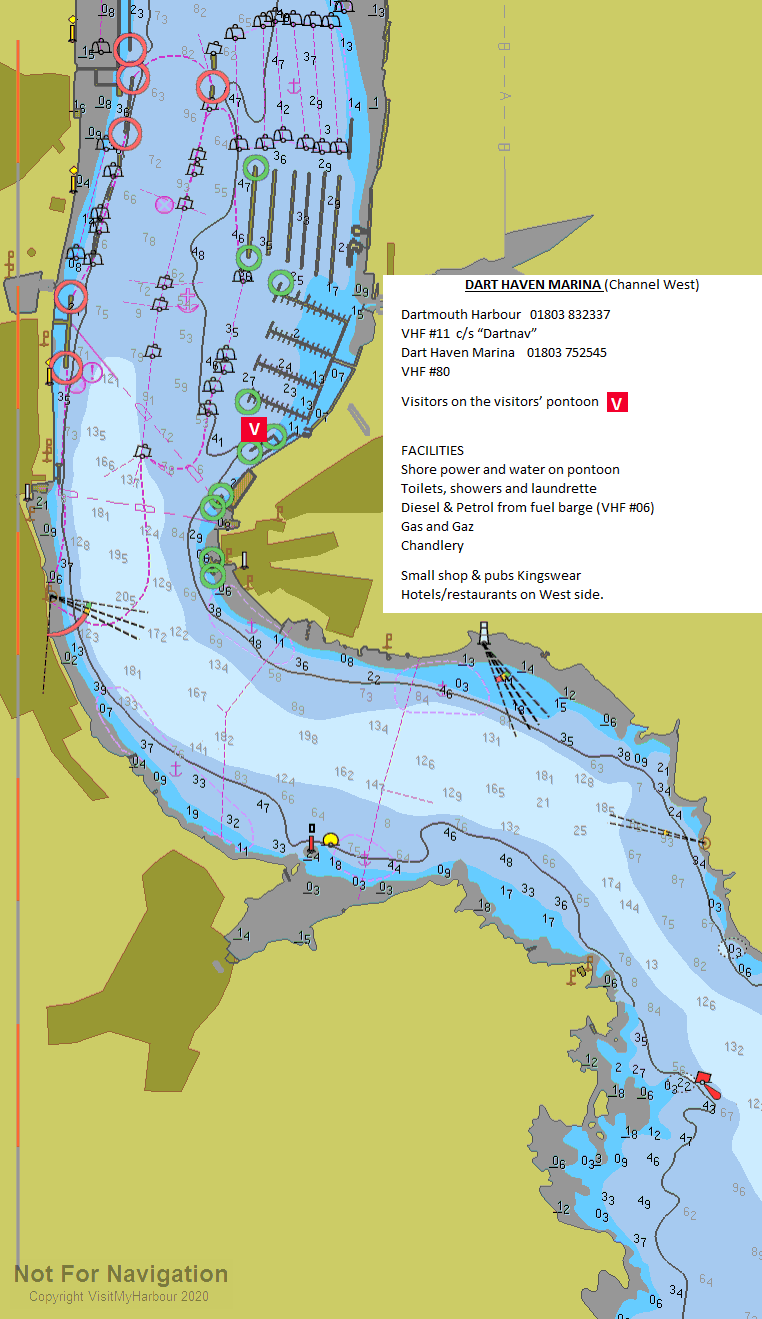
Darthaven Marina is the first one you will see when you enter and it lies on the Kingswear side... in season you may well see the steam locomotives of the Dartmouth and Paignton railway chugging in and out of the nearby station. The visitors pontoons are found on the eastern side just after the Kingswear ferry and Royal Dart Yacht Club, clearly marked on the chart. They are on VHF channel 80 or telephone 01803 752545 with a link to their website below. It's worth downloading their 2022 yearbook:
Visitor charges are £3.30 per metre, to which you have to add 95p per metre harbour charges. The good news is that everything including WiFi is covered, standfast the laundrette They can accommodate 25 boats (rafted up), and may have some vacant spaces in residents area. Facilities here include showers, bathrooms, and launderette. Electricity, water, telephone lines . A chandlery, full boatyard services, Marine and Electronics engineers and a Volvo Marine centre with breakdown facilities complete the picture. All in all pretty comprehensive. Incidentally this Marina is the only source of Calor and camping gas locally.
DART MARINA YACHT HAVEN
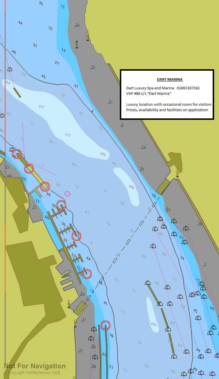
Dart Marina Yacht Harbour, lies above the town on the Western side fronted by a housing development of fancy designer houses and apartments. All of its berths are taken and it has no designated space for visitors. Words that keep cropping up where this Marina is concerned are... stylish.... sophisticated... exclusive..... luxurious... smart.... security...etc etc. It may be possible to arrange an overnight berth here if space is available, call "Dart Marina" on VHF channel 80 or telephone 01803 837161. They used to charge an astronomical price for this but have reduced their charge to match the Dart Haven Marina at £3.60 per metre to which you have to add the 95p per metre for harbour dues. Link to their website is provided below:
Leaving Dartmouth behind it is possible to continue upriver keeping mid-stream. There is plenty of water but there are a couple of hazards to watch out for. First is the upper car ferry which crosses the River on a diagonal track and berths just south of Dart Marina. This vessel runs on cables and must be given way to, always passing astern of it and giving a wide berth.
NOSS MARINA

Noss Marina lies on the eastern bank a little further north of the town, and is handy if you want to avoid the frenetic cut and thrust of the more central moorings. They are in the process of a massive regeneration and an extra large pontoon is in the process of being added. Now, in 2022, visitors berths are available on pontoons or trot moorings they will cost £3.55 + 95p per metre harbour dues for boats up to 12.5 metres and £3.80 per metre for those over 12.5 metres. NB prices quoted on their web site include VAT. Facilities include shore power at an extra cost, with showers, toilets and laundry ashore. WiFi is available. Try calling them on VHF channel 80, or telephone 01803 839087. Link to website below:
Although a bit out of the way from Dartmouth, tripper boats and water taxis (VHF channel 8 or 69) ply to and from the town. The Marina can help arrange having provisions delivered.
Premier Marinas, The new owners of Noss Marina, are building a
300 berth luxury Marina complete with Five Star Hotel, and houses
starting at £1 million each and that building is in process at the
moment
They have also installed dry stacking storage and a huge boat
lift.
Further Up River
Carry on past Noss Marina on your starboard side, and on the port hand side, the facilities of the Britannia Royal Naval College. There are often small naval vessels manoeuvring in this vicinity. Continue up the River through the local moorings and watch out for Anchor Stone on your port hand side, this 3.7 m drying rock is marked by a beacon with a red square top mark (Fl(2)R.5s) and needs to be left well to port.
At Dittisham on the western side there are several blue harbour authority visitors mooring buoys.There is easy dinghy access for the town and drinking water is available from a public tap (Jerry can job). These moorings can get crowded in summer, and rafting may be necessary. Anchoring is not allowed off the town. Limited provisioning from the local store is possible.
It is possible to continue onwards as far as Totnes, passing Galmpton Creek to the East and coming to some more harbour authority visitors moorings in the River off Stoke Gabriel. Dartside Quay at Galmpton is a major yard owned by MDL, with on-site services including chandlery, rigging, engineering and capable of major repair work, and lifts of up to 50 tonnes. Check the directory.
In the upper reaches there are some anchoring possibilities marked on the chart, and if planning a visit to Totnes and hoping to get a drying berth check with the harbour authorities first to establish availability. The Steam Packet Inn at Totnes has quayside space to dry out on with almost 3 m at high water Springs. It offers slot meter electricity on the quay, some laundry and bathroom facilities and freshwater is available. Remarkably it doesn't charge for mooring providing you use their facilities, and offers bar meals and a restaurant covering breakfasts as well. Space is limited, and they can be contacted on 01803 863880
The pilotage from Dittisham to Totnes is fairly tricky, and is well covered by the harbour authorities themselves. In this instance our guide bows to their superior knowledge and offers the link below to their comprehensive sailing directions:
http://www.dartharbour.org/visitors/category/sailing-directions
Totnes itself offers a busy shopping centre and all town facilities.
Marinas and Mooring
Dart Harbour & Navigation Authority
6 Oxford St, Dartmouth, Devon. TQ6 9AL
Teignmouth Harbour Office
Old Quay House, Old Quay, Teignmouth, Devon. TQ14 8ES
South Hams District Council
Follaton House, Plymouth Road, Totnes, Devon. TQ9 5NE
Facilities
A large fuel barge is moored in the centre of the river off Dartmouth, showing clearly on the chart. It's open from 8 AM to 6 PM daily during the summer months and they can be contacted on VHF channel 6 callsign " Fuel Barge", or on 07801 798861. Petrol and diesel are both available. Diesel is also available at the Marinas, with Calor and camping gas being available at Darthaven Marina only.
Water is available alongside at all the marinas, the Town Jetty, North and South Embankment and the Royal Dart yacht club.
Dartmouth boasts two yacht clubs, the Royal Dart Yacht Club is at Kingswear and welcomes visitors to share its facilities including showers, bar and first-class dining. They can be contacted on 01803 752272 and a link to their website is below:
Dartmouth Yacht Club is on the South Embankment (Dartmouth side), and they are on 01803 832305, with a link to their website below:
WiFi access is available in the central area of the main harbour and you can obtain information on this from the HM or the River Officer.
Owners or charterers of Robert Maxwell style super yachts moored in the River may want to send a crew member in the RIB to make arrangements for them to land at and use the facilities of the Dart Marina Yacht Harbour, already mentioned. Here they will find facilities in the style they are accustomed to, and be able to make use of the exclusive Dart Marina Hotel and Health Spa, together with the associated restaurant and bistro.
The rest of us can make do with using dinghies, or stump up from £1.00 per head each way to use the water taxis..... call them up on VHF channel 69 callsign " Yacht Taxi", or mobile 07970 346571.
An interesting floating restaurant/inn based on a Dutch barge moored opposite the town, could make a worthwhile stop. The Resnova Floating Inn is no longer
All needs for the boat can be catered for in the River Dart area, with perhaps the biggest Chandlers on the Kingwear side at Darthaven Marina. Haulings, boatyards, and all kinds of specialists are within easy reach. Check the directory.
The individual facilities available at each Marina have already been mentioned, but the town of Dartmouth can basically provide everything you will need to stock the boat up. All the major banks (with cashpoints) are represented except for Barclays, and supermarkets include Sommerfield's, Spar, and the Marks & Spencer's " Simply Food" outlet. Delicatessens and bakers will be found, and for the boat there is a Chandlers open seven days a week. For further information about the town try the tourist information centre, link below:
http://www.discoverdartmouth.com/
There are slipways for the trailer craft available at Darthaven Marina and Noss Marina, as well as at the ferry slipway on the Dartmouth side (shared with the ferry who's access must not be obstructed). Remember harbour dues must be paid separately from anything else. Other slips are available at Totnes and Dittisham.
An hourly bus goes to Totnes, from where main line rail connections are available, and the Steam Railway from Kingswear connects to Paignton for Main Line connections from Newton Abbot. Link below:
http://www.dartmouthrailriver.co.uk/days-out/steam-train-3/steam-train-2
Boatyards & Boatyard Services
Darthaven Chandlery
Brixham Road, Kingswear, Dartmouth, South Devon, TQ6 0SG
Dolphin Shipyard
Unit 3 Old Mill Boat Yard, Galmpton, Dartmouth, Devon. TQ5 0EH
Chandlers
Dartmouth Boating Centre
Riverside Court, South Embankment, Dartmouth, Devon. TQ6 9BG
Dart Marine Services
Noss Marina, Bridge Road, Kingswear, Dartmouth, Devon. TQ6 0EA
What to Do
Absolutely all tastes are catered for in Dartmouth from Michelin star restaurants owned by TV chefs (New Angel on the South Embankment), brasseries, bistros, Italian, Chinese, Indian, Thai, and tapas, not forgetting seafood.
Pubs of all types abound many of which can do a decent bar meal.
For something to do, the little boy in you would never forgive if you didn't check out the magnificent steam locomotives at Kingswear Station... and maybe even take a ride to Paignton.
The links below may give you a better idea of what's available:
Pubs
http://www.beerintheevening.com/pubs/results.shtml/el/Dartmouth%3BDevon/
Eating out Restaurants & Places to Eat in Dartmouth 2021 - Tripadvisor
Yacht Clubs and Associations
History
As you explore this harbour you may wonder about the heavy concrete launching ramps seen here and in many other harbours near by. These were built to load tanks and other armaments into landing vessels preparing for the D Day assault on Utah Beach. Thousands of young American servicemen were billeted in the area and were training hard for the forthcoming attack.
A terrible and devastating incident occurred in the early hours of 28 April 1944.... Exercise Tiger (a full-scale rehersal for the Utah beach landings) was well underway off the Devon coast when German E Boats fell upon the unsuspecting Americans. In the ensuing carnage two landing craft were sunk, one was badly damaged and 749 American servicemen (many of them teenagers) lost their lives. This was more than four times the casualties suffered than the actual D-Day assault on Utah beach. This tragedy was researched and publicised by a British man, Ken Small (sadly now dead). With the help of local residents he managed to salvage a Sherman tank and set it up as a War Memorial to those poor lads who perished that dreadful night.
The text below gives the bare facts:
In late 1943, as part of the war effort, the British Government evacuated approximately 3000 local residents in the area of Slapton, South Hams District of Devon. Some of them had never left their villages before.
Landing exercises had started in December 1943. Exercise Tiger was one of the larger exercises that would take place in April and May 1944. The make up of Slapton Beach was selected for its similarity to Utah beach, namely a gravel beach, followed by a strip of land and then a lake.
The exercise was to last from 22 April until 30 April 1944, at the Slapton Sands beach in Slapton, South Devon. On board nine large Tank landing ships (LSTs), the 30,000 troops prepared for their mock beach landing.
Protection for the exercise area came from the Royal Navy. Two destroyers, three Motor Torpedo Boats and two Motor Gun Boats patrolled the entrance to Lyme Bay and Motor Torpedo Boats were watching the Cherbourg area where German E-boats were based.
The first practice took place on the morning of 27 April. These proceeded successfully, but then early in the morning of 28 April, German E-boats that had left Cherbourg on patrol spotted a convoy of 8 LSTs carrying vehicles and combat engineers of the 1st Engineer Special Brigade in Lyme Bay and attacked. One of these E-Boats was S-130 now in dry dock in Plymouth UK. One transport caught fire and was abandoned, a second sank shortly after being torpedoed, a third was set on fire but eventually made it back to shore. The remaining ships and their escort fired back and the E-boats made no more attacks.
The attack caused over 600 casualties, compared to only about 200 in the Utah Beach invasion. 638 servicemen were killed - 441 U.S. Army and 197 U.S. Navy personnel. Many servicemen drowned in the cold sea waters while waiting to be rescued. Soldiers unused to being at sea panicked and put on their lifebelts incorrectly. In some cases this meant that when they jumped into the water, the weight of their combat packs flipped them onto their backs, pushing their heads underwater and drowning them. Dale Rodman, who travelled on LST 507, commented "The worst memory I have is setting off in the lifeboat away from the sinking ship and watching bodies float by."
Of the two ships assigned to protect the convoy, only one was present. HMS Azalea, a corvette was leading the nine LSTs in a straight line, a formation which later drew criticism since it presented an easy target to the E-boats. The second boat which was supposed to be present, HMS Scimitar, a World War I destroyer, had checked into Plymouth for minor repairs. The American forces had not been told this. When other British ships sighted the E-boats earlier in the night and told the corvette, its commander failed to tell the LST convoy, assuming incorrectly that they had already been told. This did not happen because the LSTs and British naval headquarters were operating on different frequencies. Also, British shore batteries defending Salcombe Harbour had seen silhouettes of the E-boats but had been instructed to hold fire so the Germans would not find that Salcombe was defended.
When the remaining LSTs landed on Slapton Beach, the blunders continued. The British heavy cruiser HMS Hawkins shelled the beach with live ammunition, following an order made by General Eisenhower, the Supreme Allied Commander, who felt that the men must be hardened by exposure to real battle conditions. British marines on the boat recorded in its log book (the only log which has since been recovered from any of the boats) that men were being killed by friendly fire. "On the beaches they had a white tape line beyond which the Americans should not cross until the live firing had finished. But the Marines said they were going straight through the white tape line and getting blown up".
Aftermath
As a result of official embarrassment and concerns over possible
leaks just prior to the real invasion, all survivors were sworn to
secrecy by their superiors. Ten missing officers involved in the
exercise had Bigot-level clearance for D-Day, meaning that they
knew the invasion plans and could have compromised the invasion
should they have been captured alive. As a result, the invasion was
nearly called off until the bodies of all ten victims were
found.
There is little information about how exactly individual soldiers and sailors died. Various eyewitness accounts detail hasty treatment of casualties and unmarked mass graves in Devon fields.
Several changes resulted from mistakes made in Exercise Tiger:
Radio frequencies were standardised; the British escort vessels
were late and out of position due to radio problems, and a signal
of the E-boats' presence was not picked up by the LSTs.
Better life vest training for landing troops.
New plans for small craft to pick up floating survivors on
D-Day.The casualty statistics from Tiger were not released until
August 1944 along with the casualties of the actual D-Day landings
themselves.
There is still very little documentation in official histories about the tragedy. Some commentators have called it a cover-up, but the initial critical secrecy about Tiger may have merely resulted in longer-term quietness. In his book The Forgotten Dead - Why 946 American Servicemen Died Off The Coast Of Devon In 1944 - And The Man Who Discovered Their True Story, published in 1988, Ken Small declares that the event "was never covered up; it was 'conveniently forgotten'". Charles B. MacDonald, author and former deputy chief historian at the U.S. Army Center of Military History, notes that the incident was reported in a press release issued from the Supreme Headquarters, Allied Expeditionary Force, and appeared in the July issue of Stars and Stripes. In addition, the story was detailed in at least three books at the end of the war, including, Captain Harry C. Butcher 's My Three Years With Eisenhower (1946), and in several publications and speeches in the intervening years. MacDonald surmises that the press release went largely unnoticed in light of the larger events that were occurring at the time, the battle for France in the summer of 1944, and the fact that they were just glad that the war was over in 1946.
Memorials to the victims
With little or no support from the American or British armed forces
for any venture to recover remains or dedicate a memorial to the
incident, Devon resident and civilian Ken Small took on the task of
seeking to memorialize the event, after discovering evidence of the
aftermath washed up on the shore while beachcombing in the early
1970s.
In 1974, Mr. Small bought from the U.S. Government the rights to
a submerged tank from the 70th Tank Battalion discovered by his
search efforts. In 1984, with the aid of local residents and diving
firms, he finally raised the tank, which now stands as a memorial
to the incident. The local authority provided a plinth on the
seafront to put the tank on, and erected a plaque in memory of
those men killed.
Ken Small died of cancer in March 2004, a few weeks before the 60th
anniversary of the Exercise Tiger incident.
In 2006, the Slapton Sands Memorial Tank Limited (a non-profit organization, one of whose directors is Mr. Small's son Dean) are seeking to establish a more prominent memorial listing the names of all the victims of the attacks on Exercise Tiger.
A radio play 'The Tank Man' by Julia Stoneham, describing Ken Small's efforts was broadcast on BBC Radio 4 on 24th October 2007. Ken documents how the local villagers were of more assistance than either the US or UK military officials. Later the American military honored and supported him, when at the same time the UK military were snubbing his efforts.
Exercise Tiger recently formed the basis of the last episode of the BBC Series Foyle's War.
Dartmouth History...
Dartmouth was of strategic importance as a deep-water port for sailing vessels. The port was used as the sailing point for the crusades of 1147 and 1190, and a creek close to Dartmouth Castle is supposed by some to be named for the vast fleets which assembled there (Warfleet Creek). It was a home of the English navy since the reign of Edward III and was twice surprised and sacked during the Hundred Years' War, after which the mouth of the estuary was closed every night with a great chain. The narrow mouth of the Dart is protected by two fortified castles, Dartmouth Castle and Kingswear Castle.
In 1373 Geoffrey Chaucer visited and among the pilgrims in his Canterbury Tales
A schipman was ther, wonyng fer by weste;
For ought I wost, he was of Dertemouthe.
Notwithstanding Dartmouth's connections with the crown and
respectable society, it was a major base for privateering (state
sanctioned or licenced piracy) in medieval times.
The town is dominated by the Royal Navy Officer Training college (Britannia Royal Naval College) and all officers of the Royal Navy, as well as many foreign navies, are trained there.
The Port of Dartmouth Royal Regatta takes place annually over three days at the end of August.
Originally Dartmouth's only wharf was Bayard's Cove, a relatively small but picturesque area protected by a fort at the southern end of the town. Bayards Cove has been used in several television productions, because of its 18th century buildings; photographs are on show in the Dartmouth Arms public house.
The made up embankment which today extends the whole length of the town's river front is the result of nineteenth century land reclamation, started in earnest when the town played host to a large number of prisoners of war from the Napoleonic wars which formed a captive workforce. Prior to this, what is now the town centre was almost entirely tidal mud flats.
Henry Hudson put into Dartmouth on his return from America, and was arrested for sailing under a foreign flag. The Pilgrim Fathers put into Dartmouth's Bayard's Cove, en-route from Southampton to America. They rested a while before setting off on their journey in the Mayflower and the Speedwell on the 20 August 1620. About 300 miles west of Land's End, they realised that the Speedwell was unseaworthy and returned to Plymouth. The Mayflower departed alone to complete the crossing to Cape Cod.
The town contains historic buildings, the most obvious of which
is the Butterwalk, built 1635 - 1640. Its intricately carved wooden
fascia is supported on granite columns. Charles II held court in
the Butterwalk whilst sheltering from storms in 1671 in a room
which now forms part of Dartmouth Museum. Much of the interior
survives from that time, as does at least one ghost. The Royal
Castle Hotel was built in 1639 on the then new Quay. The building
was refronted in the nineteenth century, and as the new frontage is
itself listed, it is not possible to see the original which lies
beneath. A claimant for the oldest building is a former merchants
house in Higher Street, now a Good Beer Guide listed public house
called The Cherub, built circa 1380. Agincourt House (next to the
Lower Ferry) is also 14th century.
The remains of a fort at Gallants Bower just outside the town are
some of the best preserved remains of a civil war defensive
structure. The fort was built by Royalist occupation forces in
c1643 to the south east of the town, with a similar fort at Mount
Ridley on the opposite slopes of what is now Kingswear. The
parliamentarian General Fairfax attacked from the North in 1646,
taking the town and forcing the Royalists to surrender, after which
Gallants Bower was demolished.
In the latter part of World War II the town was a base for American forces, and one of the departure points for Utah Beach in the D Day landings. Much of the surrounding countryside was closed to the public while it was used by US troops for practise landings and manoeuvres.
The Onedin Line, a popular BBC television drama series that ran from 1971 to 1980, was filmed here
Totnes
History
According to the Historia Regum Britanniae written by Geoffrey of
Monmouth in around 1136, "the coast of Totness" was where Brutus of
Troy, the mythical founder of Britain, first came ashore on the
island. Set into the pavement of Fore Street is the 'Brutus
Stone', a small granite boulder onto which, according to
local legend, Brutus first stepped from his ship. As he did so, he
was supposed to have declaimed:
Here I am and here I rest. And this town shall be called Totnes.
The stone is far above the highest tides and the tradition is not likely to be of great antiquity, being first mentioned in John Prince's Worthies of Devon in 1697. It is possible that the stone was originally the one from which the town crier, or bruiter called his bruit or news; or it may be le Brodestone, a boundary stone mentioned in several 15th century disputes: its last-known position in 1471 was below the East Gate.
Despite this legendary history, the first authenticated history
of Totnes is in AD 907, when it was fortified by King Edward the
Elder as part of the defensive ring of burhs built around Devon,
replacing one built a few years earlier at nearby Halwell. The site
was chosen because it was on an ancient trackway which forded the
river at low tide. Between the reigns of Edgar and William II
(959–1100) Totnes intermittently minted coins.
The name Totnes (first recorded in 979AD) comes from the Old
English personal name Totta and ness or headland. Before
reclamation and development, the low-lying areas around this hill
were largely marsh or tidal wetland, giving the hill much more the
appearance of a "ness" than today.
By the 12th century Totnes was already an important market town, due to its position on one of the main roads of the South West, in conjunction with its easy access to its hinterland and the easy navigation of the River Dart.
By 1523, according to a tax assessment, Totnes was the second richest town in Devon, and the sixteenth richest in England, ahead of Worcester, Gloucester and Lincoln.
Geography
The River Dart at TotnesThe town is built on a hill rising from the
west bank of the River Dart, which separates Totnes from the suburb
of Bridgetown. It is at the lowest bridging point of the river
which here is tidal and forms a winding estuary down to the sea at
Dartmouth. The river continues to be tidal for about 1 mile (1.6
km) above the town, until it meets Totnes Weir, built in the 17th
century.
Today there are two road bridges, a railway bridge and a footbridge over the river in the town. Totnes Bridge is the nearest bridge to the sea and is a road bridge built in 1826-28 by Charles Fowler.[9] At low tide the foundations of the previous stone bridge are visible just upstream—it was probably built in the early 13th century and widened in 1692. Before the first stone bridge was built there was almost certainly a wooden bridge here, and a tidal ford for heavy vehicles was just downstream. In 1982 a new concrete bridge was built about 1,000 feet (300 m) upstream as part of the Totnes inner relief road. Its name, Brutus Bridge, was chosen by the local residents. A further 0.5 miles (0.80 km) upstream, the railway bridge carries the National Rail London to Penzance Line over the river. Immediately upstream of the railway bridge is a footbridge, built in 1993 to provide access to the Totnes (Littlehempston) terminus of the South Devon Railway.
Economy
Totnes has a sizeable alternative community, and the town is known as a place where one can live a bohemian lifestyle. There are a number of facilities for artists, painters and musicians, and there is a twice-weekly market offering antiques, musical instruments, second-hand books, handmade clothing from across the world, and local organically produced products.
Emphasising the town's continuing history of boatbuilding, between 1998 and 2001 Pete Goss built his revolutionary but ill-fated 120-foot Team Philips catamaran here.
In March 2007 Totnes was the first town in the UK to introduce its own local alternative currency, the Totnes pound, to support the local economy of the town. Fourteen months later, 70 businesses within the town were trading in the "Totnes pound," accepting them as payment and offering them to shoppers as change from their purchases. The initiative is part of the Transition Towns concept, which was pioneered by Rob Hopkins, who had recently moved to Totnes.
Landmarks
St Mary's ChurchThe Norman motte and bailey Totnes Castle,
now owned by English Heritage, was built during the reign of
William I, probably by Juhel of Totnes. The late medieval church of
St Mary with its 120 feet (37 m) high west tower, visible from
afar, is built of rich red Devonian sandstone. A prominent feature
of the town is the Eastgate — an arch spanning the middle
of the main street. This Elizabethan entrance to the walled town
was destroyed in a fire in September 1990, but was rebuilt.
The ButterwalkThe ancient Leechwell, so named because of the
supposed medicinal properties of its water, and apparently where
lepers once came to wash, still provides fresh water. The
Butterwalk is a Tudor covered walkway that was built to protect the
dairy products once sold here from the sun and rain. The town
museum is in one of the many authentic Elizabethan
Merchant's houses in the town, built around 1575.
Transport
The A38 passes about 7 miles (11 km) to the west of Totnes,
connected to the town by the A384 from Buckfastleigh and the A385
which continues to Paignton. The town also lies on the A381 between
Newton Abbot and Salcombe. Totnes railway station is situated on
the London to Penzance Line, and has trains direct to London and
Plymouth. Nearby, Totnes (Littlehempston) railway station is at the
southern end of the South Devon Railway Trust which runs tourist
steam locomotives along the line that follows the River Dart up to
Buckfastleigh. Since the River Dart is navigable to seagoing boats
as far as Totnes, the estuary was used for the import and export of
goods from the town until 1995, and there are still regular
pleasure boat trips down the estuary to Dartmouth.
The text on this HISTORY page is covered by the following
licence
http://en.wikipedia.org/wiki/Wikipedia:Text_of_the_GNU_Free_Documentation_License
Local Business
Brokers/New Boat Sales
Ancasta International Boat Sales
Darthaven Marina, Brixham Road, Kingswear, Dartmouth, Devon. TQ6 0SG
Boat Charters
Dartmouth Yacht Charters
The Old Library, Higher St, Kingswear, Devon. TQ6 0AG
Boat Storage
Divers/Diving and related services
Millenium Marine Divers
Ground Floor 1, Cannon Road, Heathfield Ind Estate, Newton Abbot, Devon. TQ12 6SG
Marine Engineering
Darthaven Engineering Ltd
c/o Darthaven Marina Complex, Brixham Road, Kingswear, Dartmouth, Devon. TQ6 0SG
C & O Marine & General Engineering
Unit 11 Watermota Works, Abbotskerswell, Newton Abbot, Devon. TQ12 5NF
Riverside Marine Engineering
Unit 2 Oldmill Boatyard, Dartmouth, Devon. TQ6 0HN
Stephenson Marine Engineers
Noss Marina, Bridge Road, Kingswear, Dartmouth, Devon. TQ6 0EA
Chris Hoyle Marine Ltd
Lower Contour Road, Kingswear, Dartmouth, Devon. TQ6 0AL
Marine Electrics/Electronics
Sea Schools
Stoke Gabriel Boating Association
Coppice View, The Quay, Stoke Gabriel, Devon. TQ6
Mattew Halkes Ltd
Burleigh, Paignton Road, Stoke Gabriel, Totnes, Devon. TQ9 6SJ
Dartmouth Yacht Cruise School
The Marina Office, Winsland Avenue, Totnes, Devon. TQ9 5FT
Sailmakers, Repair & Covers
Other-Businesses
Marine Gas Safety
Silver Springs, Paignton Road, Stoke Gabriel, Totnes, Devon. TQ9 6SJ
Compass Marine ( The Fender Co )
Compass Cottage, Castle Road, Dartmouth, Devon. TQ6 0JN
Bay Rigging
Units 1 & 2 Dartside Quay, Galmpton, Brixham, Devon. TQ5 0EH