You are viewing the expanded version of this Harbour,
for faster browsing
use the regular version here

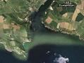
Salcombe Harbour (and Kingsbridge Estuary)
Courtesy Flag
Flag, Red EnsignWaypoint
Wolf Rock Buoy 50;13'.53N 003:46'.58WCharts
Admiralty 28, SC5602 SC5903 SC5914Rules & Regulations
The speed limit is 8 knots throughout the harbour with a 6 knot zone from the Marine Hotel to the Saltstone, ie right through all of the moorings.Hazards
Dangerous Bar...see notes. Various Charted Rocks in Approach and Entrance areasTidal Data Times & Range
HW Dover -0523 MHWS 5.3m MHWN 4.1m MLWN 2.1m MLWS 0.7m (links)This site is designed for slower, roaming broadband connections, like you would get at sea, so it needs JavaScript enabled to expand the text.
General Description
Contacts:
Harbour Master 01548 843791 VHF #14
"Ria de Salcombe"... doesn't have quite the ring to it as "Ria de Muros" or "Ria de Vigo" but neverthelessthis is a Ria, a flooded valley, the same as the magnificent Rias of North-West Spain. It is also one of the most popular stopovers for cruising boats West of the Solent, coping with thousands of visitors every year. There is no commercial and little fishing activity based at this harbour, because the harbour is bounded by a bar that can be dangerous at times. In stiff onshore conditions, or with a heavy swell Salcombe cannot considered a harbour of refuge, Dartmouth is available to the East, and Plymouth to the West.
The bar with its associated breaking seas, becomes dangerous in onshore winds, particularly from the south-east, and is at its worst when a fast ebbing tide meets heavy onshore swell and winds. Even if the winds have died down, an onshore swell meeting an outgoing tide can cause dangerous breakers. The local lifeboat "William and Emma" was overwhelmed at the bar in 1916, with a loss of 13 lives. Having given this gloomy warning it should be remembered that over 6000 boats a year visit this extremely attractive harbour, and in settled summer conditions, with careful attention to pilotage there should be no problems.
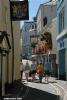
The area has not been overdeveloped, being slightly off the beaten track, and its main attraction lies in the natural beauty of the surroundings. There are busy sandy beaches, but also drying creeks where the shoal draft boat can find some solitude. The quaint and attractive little town, with a slightly upmarket feel to it, can provide all the day-to-day needs for boat and provisioning. Salcome is overly endowed with "designer" boutiques (for those who think the height of style is to be a walking advertisement for someone else's goods), but lacks a pukka supermarket, which must say something about the summertime residents and visitors.
The local harbour authority has a mammoth task on their hands dealing with visitors, and are out and about all over the place enforcing regulations, collecting money, and generally making sure visitors can enjoy themselves in an orderly fashion.
Due to overcrowding and for reasons of safety during July and August yachts are not permitted to sail within the harbour and must use their engines. Furthermore, powerboats take note, the speed limit of 8 kn and 6 Knts through the moorings is vigorously enforced.
Approach
Approaching Salcombe Harbour from the West involves passing....
..... Bolt Head at a good distance to avoid Little Mew Stone and Mewstone, both conspicuous and standing 5 m and 19 m respectively. The entrance to the harbour will start revealing itself. In lumpy weather especially with an ebbing tide it is wise to give Bolt Head a wide berth.
From the East once past Prawle Point the best plan is to keep about five cables off the coast, and then swing over to the West towards the region of Starehole Bay, while trying to identify the leading marks, and turning onto a northerly heading when they have been identified.
At night the sectored light displayed from the rear leading beacon on Sandhill Point leads the way in with its narrow white sector 357.5° to 002.5° T, and its characteristics are RGW 2s. Too far to the East and you will see green, too far to the west you will see red.
By day or night do not get too close to the north-eastern corner of Starehole Bay where the submerged Cadmus Rocks and the visible but unlit Little Eelstone await the unwary. Keep a good cable off the Western shore.
Further Pilotage Details...
The leading marks consist of the beacon mounted on the Poundstone, which has a red top mark and a red and white striped pole. Behind this and above it on Sandhill Point is the lit beacon, which has a white diamond top mark with horizontal red stripes, mounted on a white post. These marks are not always easy to spot during the day but there is a prominent red brick gabled house about halfway up the wooded Sandhill Point, and the rear beacon is directly under the left hand gable. Once the marks are identified and lined up which should happen on a bearing of 000° you can follow them in to cross the bar, with the best water slightly to the West of this leading line.
Bear in mind the gloomy warnings given earlier, for a first visit the ideal situation is to have offshore winds, wait until around half flood, and at a time of minimal groundswell. At all times with this bar great caution is needed and if you see breaking seas in the area or anything else causes you to have misgivings, the seaman like thing to do is to stand off into deeper water and assess the situation. "Salcombe Harbour" on VHF channel 14 or telephone 01548 843791 may be able to advise. LWS can be as low as 0.5m so, in places it can get very shallow.
Once over the bar locate and identify the red can Bass Rock Buoy (Q.R) and the green cone Wolf Rock Buoy (Q.G). The leading line followed will take you between them, and they both mark rocky patches awash at LWS. Favouring the green side continue northwards and locate the Blackstone beacon on your starboard side which marks an extensive drying patch lying to the West of it (check the photo gallery). The navigable channel through the turn to 042° is marked by a further four lateral marks, two on the port hand, Poundstone and Castle and two to Starboard, Blackstone South and North. (They straddle the Blackstone Beacon itself)
At night there is a transit that will take you through the centre of the harbour in deep water, and it is marked by two quick flashing leading lights (Q) mounted just to the north of Scoble Point. These line up on a course of 042°. The deepwater runs central in the channel now, and all is straightforward, but be aware that the spring ebb can get up to 3Knts off the town.
Berthing, Mooring & Anchoring
There is no Marina in Salcombe. The options are either....
.... to lay to your own anchor, or take a harbour authority mooring. However there are two 12m berths on the Whitestrand Commercial Pontoon which are available from 1900 to 0800. These alongside berths in the centre of Salcombe have water, electricity and easy access to the showers but you will be charged extra for these (see below) You will be charged £1.00p a metre for anchoring and £2.00 per metre for a mooring, in the high season with various deals available for longer stays and incentives to encourage yachtsmen and motorboaters outside of June, July and August. The Whitestrand alongside berths are charged at 25% more than the current mooring charge, which varies depending on the time of year. Owners of heavyweight leviathans can be accommodated by arrangement as the authorities have some mooring buoys capable of handling 60 tonnes.
There is an Anchorage available outside the harbour in the Starehole Bay. This is suitable only in settled weather and even then maybe uncomfortable. Care needs to be taken as the wreck of the barque "Herzogin Cecilie" lurks in the north-west corner marked by a red and black isolated danger buoy.
Salcombe Harbour Mooring Information...
Within the harbour proper the popular anchorages are shown on our charts, starting with Sunny Cove just beyond the drying Blackstone Rocks previously described. It boasts a clean sandy beach, carries 2 m at low water, and is really only suitable in settled weather. It is clearly visible on one of the photographs.
Further into the harbour there is an area where anchoring is prohibited because of underwater cables showing clearly on the charts.
Other anchoring options in this immediate area are opposite the Salcombe Harbour Hotel in Smalls Cove, and on the edge of the steep to channel the area of Ditch End.
There is no room to anchor on the Salcombe Town side as it is taken up with moorings.
The harbour authority visitors moorings will be seen, all marked with a "V" and the maximum permitted size. These numbered buoys don't have pickup strops, just a large ring so some nimble foredeck work will be needed. (If stopping for a few days it's advisable to pass your anchor chain through the ring or carry a strop with a metal bridle for the purpose) A number of these buoys lie directly off the town, and some on the opposite side. It is quite likely during the season that you will be met and directed to a berth by the harbour staff, who are available on VHF channel 14 or telephone 01548 843791 for the office. It is also very likely at peak periods that as many as four boats may be put on a single buoy so you should rig fenders on both sides in preparation for this. The charts show the location of the visitors buoys, and the main fairway must be kept clear. A link to the harbour website is given below:
http://salcombeharbour.eu/
Deeper into the harbour away from the town, anchorage is available in an area known as The Bag tucked in behind Snapes Point, where the harbour authority maintain a large deepwater pontoon for visitors (same price as mooring). The advantage of moving beyond Snapes Point is that of a peaceful berth undisturbed by lumpiness and less frenetic small craft activity. The disadvantage is a long dinghy ride to the town.
Further north there are some pontoons opposite the Mabel Shoal and another set just round Tosnos Point; both sets of pontoons are for residents boats and should not be used unless directed to do so by the harbour staff. On the other hand it is possible to anchor in the deeper water to the west of the Salt Stone
The intrepid shallow draught creek crawler can bump his way up the channel on a rising tide as far as Kingsbridge, where right at the end he will find a visitors pontoon for bilge keelers and a convenient wall where long keeled boats of up to 12 m can dry out (Same charges apply). During springs it should be possible to find 2 m at Kingsbridge. Do not confuse the first pontoons and facilities you see here with the Town Moorings, as they belong to the Kingsbridge Ferry and are strictly private.....keep going for the Town.
It's possible for a shoal-draught boat to get right up to the top of Frogmore Creek where there's a pontoon for boats under 7m (with a walk through a field of cattle to get to the village) and the possibility of anchoring IF you can find room. Same prices as down in the town. Thanks to Tyro Sailor for this info.
Further Berthing Information
A Word of Welcome from the previous Salcombe Harbourmaster...
Welcome to Salcombe and Kingsbridge Estuary. We are extremely proud of our Harbour and hope that you enjoy your visit with us. If there is anything that I or my staff can help you with or you have any suggestions how we might improve our level of service, please let us know.
Every harbour has a different character, providing a varying array of services and facilities. We have charted a slightly different course from some harbours by avoiding overdevelopment and trying to maintain the character of the Estuary. This does present its own special challenges as more and more yachtsmen get used to marina facilities, which clearly we do not have in Salcombe. We are trying to improve the level of service and quality of our facilities each year, the new visitors pontoons in Kingsbridge and Salcombe are part of this programme of improvements.
In response to feedback from estuary users the Bye-Laws have been modified to introduce a six knot speed limit zone from the Marine Hotel to the Saltstone, including South Pool Creek, and also in the Kingsbridge Basin. Notwithstanding this reduction in the speed limit I would request that mariners always proceed at a safe speed and keep a good lookout. Please be considerate and minimise your wash. Some boats make considerable wash even at six knots.
We all hope that you enjoy your time with us in the Salcombe and Kingsbridge Estuary and look forward to welcoming you back again soon.
Harbour Master
Facilities
Most needs for the boat can be met in Salcombe, including but not limited to Chandlers, repairs (with slipping up to 10 tonnes), Marine and electronic engineering, sail makers, riggers, and even life raft servicing and repairs. Check the directory.
Freshwater is available on the shortstay visitors pontoon by the harbour office (Normandy pontoon).... 30 minutes maximum, dinghys on the inside only. Fresh water is available on the Visitor's pontoon in the Bag, provided daily at 1100 through July and August, by the Harbour Authority. The fuel barge marked on the chart is open from the end of June to mid-September, call VHF channel 6 or telephone 07801 798862.
The harbour launches also serve as a water taxi service, call on VHF channel 12, they work in season from around 8 AM to 11:30 PM and you will pay between £1.50 to £3.00 per person each way depending how far you are from the town.
Rubbish disposal is catered for by a floating recycling facility in the entrance to Baston Creek, and also on the visitors’ pontoon at The Bag. Please help us by recycling your paper, cardboard, cans, plastic bottles and glass.
For the 2013 Season the Harbour Authority has provided free showers at Whitestrand for the use of visiting yachtsmen.
Salcombe Yacht Club in Cliff House, just north of the Salcombe Harbour Hotel, has showers, bar and full catering facilities. There is a running line below the Club's Race Box (The Watch House) which is available for small tenders to use. The crews of visiting yachts are welcomed and the views from the Club's terrace looking out over the Estuary are some of the best in Town. During July and August Salcombe Yacht Club hosts 3 major dinghy Regatta's each year which add to the spectacle of Salcombe. Telephone 01548 842872, link to website below:
Calor and camping gas are available from the chandlery and the DIY centre in Island street.
There are two or more options for trailer boats, the first being The Quay at Kingsbridge which has access at about a quarter of the tidal range, telephone 01548 843791. The Boat Park at Baston Creek offers a large concrete easy-to-use ramp, usable at all states of the tide. This comes at a price... Apart from any launching fees Salcombe harbour dues have to be paid, speed limits are vigourously enforced (8knts) and jetskis are not allowed.
WiFi Internet access is available in the harbour and The Bag, and ashore at some of the cafes. The public library also has Internet facilities.
Laundry can be dealt with in the Fore Street launderette, and also at Kingsbridge.
The Health Centre is marked on the main chart telephone 01548 842248.
No station, but local buses to Kingsbridge and from there other buses connect with Plymouth or Totnes for mainline trains. Car hire and taxis readily available. For further information try the Tourist Information Centre based at the Town Hall, telephone 01548 843927, link to website below:
http://www.salcombeinformation.co.uk/
For a big stock up of the boat perhaps Salcombe is not ideal, although all provisions are available there is no supermarket as such, and it requires a dingy mission. Salcombe may not boast a pukka supermarket, but does have a butchers, bakers and greengrocer, so your day to day needs can be met ashore here.
There are a full range of supermarkets at Kingsbridge.
There are numerous touristy shops and designer outlets. Fancy eating and drinking places abound, together with a couple of banks/cashpoints to top up your dwindling wallet. For serious provisioning Kingsbridge (an altogether less touristy place) has a Somerfield supermarket. Bustling street markets on Tuesdays and Thursdays and a full complement of pubs restaurants and cafes complete the picture. It can be reached by shoal draft craft for walk on access as described earlier and by local bus and even by ferry from Salcombe when the tide serves.
Welcome to Kingsbridge - South Hams (hellokingsbridge.co.uk)
History
As you explore this harbour you may wonder about the heavy concrete launching ramps seen here and in many other harbours near by. These were built to load tanks and other armaments into landing vessels preparing for the D Day assault on Utah Beach. Thousands of young American servicemen were billeted in the area and were training hard for the forthcoming attack.
A terrible and devastating incident occurred in the early hours of 28 April 1944.... Exercise Tiger (a full-scale rehersal for the Utah beach landings) was well underway off the Devon coast when German E Boats fell upon the unsuspecting Americans. In the ensuing carnage two landing craft were sunk, one was badly damaged and 749 American servicemen (many of them teenagers) lost their lives. This was more than four times the casualties suffered than the actual D-Day assault on Utah beach. This tragedy was researched and publicised by a British man, Ken Small (sadly now dead). With the help of local residents he managed to salvage a Sherman tank and set it up as a War Memorial to those poor lads who perished that dreadful night. The website below covers this incident fully, with pictures and plenty of input from people who were there at the time:
http://www.combinedops.com/Op_Tiger.htm
The text below gives the bare facts:
In late 1943, as part of the war effort, the British Government evacuated approximately 3000 local residents in the area of Slapton, South Hams District of Devon. Some of them had never left their villages before.
Landing exercises had started in December 1943. Exercise Tiger was one of the larger exercises that would take place in April and May 1944. The make up of Slapton Beach was selected for its similarity to Utah beach, namely a gravel beach, followed by a strip of land and then a lake.
The exercise was to last from 22 April until 30 April 1944, at the Slapton Sands beach in Slapton, South Devon. On board nine large Tank landing ships (LSTs), the 30,000 troops prepared for their mock beach landing.
Protection for the exercise area came from the Royal Navy. Two destroyers, three Motor Torpedo Boats and two Motor Gun Boats patrolled the entrance to Lyme Bay and Motor Torpedo Boats were watching the Cherbourg area where German E-boats were based.
The first practice took place on the morning of 27 April. These proceeded successfully, but then early in the morning of 28 April, German E-boats that had left Cherbourg on patrol spotted a convoy of 8 LSTs carrying vehicles and combat engineers of the 1st Engineer Special Brigade in Lyme Bay and attacked. One of these E-Boats was S-130 now in dry dock in Plymouth UK. One transport caught fire and was abandoned, a second sank shortly after being torpedoed, a third was set on fire but eventually made it back to shore. The remaining ships and their escort fired back and the E-boats made no more attacks.
The attack caused over 600 casualties, compared to only about 200 in the Utah Beach invasion. 638 servicemen were killed - 441 U.S. Army and 197 U.S. Navy personnel. Many servicemen drowned in the cold sea waters while waiting to be rescued. Soldiers unused to being at sea panicked and put on their lifebelts incorrectly. In some cases this meant that when they jumped into the water, the weight of their combat packs flipped them onto their backs, pushing their heads underwater and drowning them. Dale Rodman, who travelled on LST 507, commented "The worst memory I have is setting off in the lifeboat away from the sinking ship and watching bodies float by."
Of the two ships assigned to protect the convoy, only one was present. HMS Azalea, a corvette was leading the nine LSTs in a straight line, a formation which later drew criticism since it presented an easy target to the E-boats. The second boat which was supposed to be present, HMS Scimitar, a World War I destroyer, had checked into Plymouth for minor repairs. The American forces had not been told this. When other British ships sighted the E-boats earlier in the night and told the corvette, its commander failed to tell the LST convoy, assuming incorrectly that they had already been told. This did not happen because the LSTs and British naval headquarters were operating on different frequencies. Also, British shore batteries defending Salcombe Harbour had seen silhouettes of the E-boats but had been instructed to hold fire so the Germans would not find that Salcombe was defended.
When the remaining LSTs landed on Slapton Beach, the blunders continued. The British heavy cruiser HMS Hawkins shelled the beach with live ammunition, following an order made by General Eisenhower, the Supreme Allied Commander, who felt that the men must be hardened by exposure to real battle conditions. British marines on the boat recorded in its log book (the only log which has since been recovered from any of the boats) that men were being killed by friendly fire. "On the beaches they had a white tape line beyond which the Americans should not cross until the live firing had finished. But the Marines said they were going straight through the white tape line and getting blown up".
Aftermath
As a result of official embarrassment and concerns over possible leaks just prior to the real invasion, all survivors were sworn to secrecy by their superiors. Ten missing officers involved in the exercise had Bigot-level clearance for D-Day, meaning that they knew the invasion plans and could have compromised the invasion should they have been captured alive. As a result, the invasion was nearly called off until the bodies of all ten victims were found.
There is little information about how exactly individual soldiers and sailors died. Various eyewitness accounts detail hasty treatment of casualties and unmarked mass graves in Devon fields.
Several changes resulted from mistakes made in Exercise Tiger:
Radio frequencies were standardised; the British escort vessels were late and out of position due to radio problems, and a signal of the E-boats' presence was not picked up by the LSTs. Better life vest training for landing troops.
New plans for small craft to pick up floating survivors on D-Day.The casualty statistics from Tiger were not released until August 1944 along with the casualties of the actual D-Day landings themselves.
There is still very little documentation in official histories about the tragedy. Some commentators have called it a cover-up, but the initial critical secrecy about Tiger may have merely resulted in longer-term quietness. In his book The Forgotten Dead - Why 946 American Servicemen Died Off The Coast Of Devon In 1944 - And The Man Who Discovered Their True Story, published in 1988, Ken Small declares that the event "was never covered up; it was 'conveniently forgotten'". Charles B. MacDonald, author and former deputy chief historian at the U.S. Army Center of Military History, notes that the incident was reported in a press release issued from the Supreme Headquarters, Allied Expeditionary Force, and appeared in the July issue of Stars and Stripes. In addition, the story was detailed in at least three books at the end of the war, including, Captain Harry C. Butcher 's My Three Years With Eisenhower (1946), and in several publications and speeches in the intervening years. MacDonald surmises that the press release went largely unnoticed in light of the larger events that were occurring at the time, the battle for France in the summer of 1944, and the fact that they were just glad that the war was over in 1946.
Memorials to the victims
With little or no support from the American or British armed forces for any venture to recover remains or dedicate a memorial to the incident, Devon resident and civilian Ken Small took on the task of seeking to memorialize the event, after discovering evidence of the aftermath washed up on the shore while beachcombing in the early 1970s.
In 1974, Mr. Small bought from the U.S. Government the rights to a submerged tank from the 70th Tank Battalion discovered by his search efforts. In 1984, with the aid of local residents and diving firms, he finally raised the tank, which now stands as a memorial to the incident. The local authority provided a plinth on the seafront to put the tank on, and erected a plaque in memory of those men killed.
Ken Small died of cancer in March 2004, a few weeks before the 60th anniversary of the Exercise Tiger incident.
In 2006, the Slapton Sands Memorial Tank Limited (a non-profit organization, one of whose directors is Mr. Small's son Dean) are seeking to establish a more prominent memorial listing the names of all the victims of the attacks on Exercise Tiger.
A radio play 'The Tank Man' by Julia Stoneham, describing Ken Small's efforts was broadcast on BBC Radio 4 on 24th October 2007. Ken documents how the local villagers were of more assistance than either the US or UK military officials. Later the American military honored and supported him, when at the same time the UK military were snubbing his efforts.
Exercise Tiger recently formed the basis of the last episode of the BBC Series Foyle's War.
Salcombe History
The town is close to the mouth of the Kingsbridge Estuary, built mostly on the steep west side of the estuary and lies within the South Devon Area of Outstanding Natural Beauty (AONB). The town's extensive waterfront and the naturally sheltered harbour formed by the estuary gave rise to its success as a boat- and ship-building and sailing port and, in modern times, tourism especially in the form of pleasure sailing and yachting. There is also a crabbing industry.
Many of the houses in Salcombe are used as second homes by non-locals.
History
There are a number of shipwrecks off Salcombe. One is of a Bronze Age ship, one of only three known in Britain, which had French made weapons and jewellry. The Salcombe Cannon Wreck is of a 17th century ship that contained 400 Moroccan gold coins and Dutch items. In 1936 a famous Finnish 4 masted barque, Herzogin Cecilie stranded at Bolt Head. Also off Salcombe is HMS Untiring (P59) which is a Second World War submarine that was sunk in 1957 as a sonar target.
A description of the South Hams is given in the 9th century charter S298. This does not show Salcombe but its area is part of Badestone (Batson). "Salcombe" first appears in the records in 1244, on the boundaries of Batson and West Portlemouth. In 1570 there were 56 mariners while two years later another survey shows 5 ships under 60 tons at Salcombe.
In 1566 there were 10 seine nets at Salcombe while in the 1580s Salcombe fishermet travelled to Padstow annually for the new herring fishery. While there they rented cottages and storehouses.
During the English civil war the town sided with the Royalists and held out against the Roundheads. The ruins of Fort Charles remain towards the south of the town. It held out from January to May 1646 and was the last Royalist stronghold. This fort was built for Henry VIII to defend the estuary. It was slighted on the orders of Parliament.
There is liitle record of the town between 1650 and 1750 but it is thought that the inhabitants lived by fishing and smuggling. In 1764 the first holiday home, The Moult, was built in Salcombe.
In the 19th century Salcombe was a major centre for shipping in the fruit trade. Salcombe vessels sailed to Iberia, the Mediterranean and the Caribbean as well as to the Azores and Newfoundland. The fruit cargos were oranges and lemons from the Azores, and pineapples from the Bahamas and West Indies. Other cargoes brought back included sugar, rum, cocoanuts and shaddocks. In addition wood such as ebony and mahogany was brought for furnishing ships. Salcombe and Kingsbridge were busy ship building places, producing the Salcombe schooner. This was a fast boat that could be sailed with few hands. However, almost half the fleet were lost with all hands. A mutual marine assurance association had been established in 1811 to insure Salcombe ships.
The Salcombe fleet also was involved in the coastal trade supplying coal from Wales and taking away cider, malt, grain and slates. A ferry to Brest was set up in 1870 but did nor last.
By 1871 the central part of Salcombe, excluding the outlying districts, numbered 776 people, with 34 shipwrights and 13 ships carpenters. There were also 5 sawyers, 3 block makers, 2 ship's riggers, 3 sail makers, a tin plate worker and 4 blacksmiths. However, in the 1870s the fruit trade declined due to outbreaks of orange and pineapple disease and because of the advent of steamships. Some work was found taking salt to Newfoundland and returning with cod but by 1914 there were only three or four locally owned trading ships in the estuary. At this time there was the start of pleasure sailing at Salcombe with the yacht club being founded in 1874. One of the boats raced was the Salcombe yawl for which an owner's association has been set up.
Salcombe became a ship registry port in 1864 but still came under Dartmouth for customs. A customs house was later built at Salcombe which still exists. Between 1796 and 1887 at least 200 vessels were launched from Salcombe. To have more space the shipyards were extended by reclaiming the foreshore. These were later built over and new ones made in Shadycombe Creek. However, many vessels were lost, including 7 local boats off the Azores in November 1851. There were four sailmakers lofts at Salcombe and three shipsmiths in 1851. The majority of the Victorian houses seen in Salcombe today were built by shipowners and masters. After 1880, with the advent of steam propulsion and larger ships, there was less new construction and repair work. Salcombe's seamen and craftsmen moved to the deep sea fishing ports or to the dockyards.
A turnpike road was built to Salcombe in 1824. Originally Salcombe was part of Malborough parish but a chapel-of-ease was built at Salcombe in 1401. The parish church was not built until the 19th century. The population of Salcombe was 972 in 1841 but had risen to about 1500 by 1850. There is also a Wesleyan Chapel and a Catholic Church.
Between the two world wars Salcombe developed as a holiday resort, with Salcombe Sailing Club being founded in 1922.
During the second world war a radar station was set up on Bolt Head and Salcombe became an Advance Amphibeous Base for the United States Navy in September 1943. The Salcombe Hotel became the latter's headquarters and 60 other properties were requistioned, as well as Quonset huts being built on the hill near the Rugby Club. Whitestrand Quay and slipway was constructed. 137 officers and 1793 men were based at Salcombe. 66 ships and many auxiliary vessels sailed from Salcombe on 4 June 1944 as part of "Force U" which landed on Utah Beach, Normandy. Afterwards Shadycombe Creek and Mill Bay were used to repair damaged landing craft. The Base closed on 7 May 1945. A plaque was set up in Normandy Way to commemmorate the United States Navy. Salcombe and district suffered a number of bombing raids during the war.
The former radar station at Bolt Head near Salcombe was set up to be used as the Regional Seat of Government in the event of attack during the Cold War. This has subsequently been dismantled.
There have been many changes to the Salcombe Waterfront since World War II, the most noticeable being the construction of the Creek car and boat park, and the road to Batson. Salcombe became an urban district following an Act of Parliament in 1972.
One of the most extraordinary cases in British criminal history took place in Salcombe. John Allen (originally Anthony John Angel) was convicted of murdering his wife Patricia and their two children 27 years after the event. They disappeared without trace in May 1975 and were never found. He claimed that she had walked out on him but his ex-lover, Eunice Yabsley, later claimed that she had seen scratches on his forearms. After falling out with him, she wrote a book "Presumed Dead" in 1992 and the police re-investigated the case. John Allen was convicted in December 2002.
Estuary
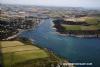
Salcombe and Kingsbridge estuary lies between Bolt Head and Sharpitor on the west and Portlemouth Down on the east, and runs inland for some 6 kilometres, with numerous side channels. The "estuary" is actually a ria or drowned valley caused by rising sea levels rather than a true estuary: its size is out of proportion to the few streams which discharge into it. It may have been carved out by glacial melt water at the end of the ice age.
Bar and lifeboat
Towards the mouth of the estuary is the Bar, a spit of sand protruding from the east bank which is exposed at low spring tides. In this state of tide and with strong southerly winds the bar can make the entrance to the estuary nearly impassable.
It is believed that Lord Tennyson's famous poem "Crossing the Bar" was inspired by a visit to Salcombe during the 19th century. The poem begins with the lines,
“ Sunset and evening star and one clear call for me!
And may there be no moaning of the bar,
When I put out to sea ”
The moaning refers to the noise of the water breaking over The Bar. A lifeboat station was established in 1869. In 1916 the Salcombe lifeboat, an open rowboat "The William and Emma", was capsized crossing The Bar resulting in 13 of the 15 crew's lives being lost. However another crew was soon formed and the station continues to this day. There is an offshore boat and an Atlantic 75 inshore boat "Joan Bate" (2003). The offshore boat has recently been replaced, at Easter of 2008, with a new Tamar class boat called "Baltic Exchange III". The old lifeboat house on South Sands is no longer used and there is a lifeboat museum in Salcombe town.
Beaches
The ferry jetty at SalcombeFurther into the estuary on the east side are a series of popular sandy beaches: Sunny Cove (nearest the bar), the large Mill Bay, Cable Cove (the landing point of a cross-channel cable)[10], Small's Cove and Fisherman's Cove. Adjacent to Fisherman's Cove is a landing slip used by the ferry — open-topped clinker-built motorboats — from Salcombe directly across the estuary, communicating with the hamlet of East Portlemouth (and much used by tourists for access to the beaches).
Opposite the Bar on the west side of the estuary are the beaches of South Sands and North Sands. A picturesque ferry operates between Salcombe and South Sands, with a Sea Tractor ferrying passengers between the boat and the South Sands beach.
North of North Sands Salcombe town begins, occupying the steep west side of the estuary opposite the beaches and East Portlemouth and extending north and west into the first of the estuary's many creeks: Batson Creek by Snapes Point. Others, including Southpool Creek and Frogmore Creek, branch off to the east and north east, while the main channel continues to Kingsbridge itself. A larger boat operates in the summer as a ferry between Salcombe and Kingsbridge when the state of the tide permits. Salcombe now also has spread down the west side of The Berry below the main road to Malborough.
Economy
Probably due to its popularity for pleasure such as sailing and yachting, Salcombe has the second highest property prices in the UK outside of central London (after Sandbanks, Poole). Many of the shops, bars and restaurants in the town, especially towards the waterfront, cater for a predominantly well-off, fashionable and nautically-inclined clientele, with prices to match. There are many clothes shops and art galleries. Salcombe has hotels and bed and breakfast establishments as well as self contained apartments and houses.
Salcombe has a number of boatyards and marine stores, while boats are stored on the carpark by the fishing quay during the winter. There is a sailing school based on the ex-Mersey ferry "Egremont" moored in the estuary. There is also a power boat school and SCUBA diving is popular. The regatta weeks are one of the main features of the summer season. There are races for dingies and yachts as well as crabbers in addition to other activities. Salcombe Estuary Rowing Club is a member of the Cornish Pilot Gig Association and takes part in races around the south west.
Fishing is still carried out at Salconbe, mostly of shellfish. About 2000 tons a year were landed between 1986 and 1990
Salcombe has some celebrity residents, including Sir Clive Woodward, Kate Bush, Sir Michael Parkinson, and members of Led Zeppelin. The local celebrity is the England Rugby prop Julian White who played mini-rugby and Under 16's for Salcombe. Properties with estuary or sea views can fetch between £1m and £5m and some rent for as much as £12000 a week in the high season.
Facilities
Because of the narrow streets and the priority given to pedestrians, a park and ride scheme operates during the summer from the outskirts of Salcombe. Near Salcombe primary school is a swimming pool. The rugby club is a centre of activities during the winter. A locally-flavoured pantomime is put on near Christmas.
There is a marine museum in Salcombe that has information on the fruit schooners and other items of interest. By South Sands is Overbeck's a house and gardens belonging to the National Trust. In the house are inventions of Otto Overbeck.
Salcombe is a good place for walking and is on the South West Coast Path. It is also the terminus of NCR 28 from Okehampton, part of the National Cycle Network.
There is a golf course nearby at Thurlestone and various tourist attractions in the district.
The text on this HISTORY page is covered by the following licence
http://en.wikipedia.org/wiki/Wikipedia:Text_of_the_GNU_Free_Documentation_License
Eating, Drinking & Entertainment
For the energetic there are excellent walks either side of the Ria, with safe swimming from any of the sandy beaches in the harbour. History buffs will probably find the Salcombe Maritime Museum and the Lifeboat Museum of interest, whilst fashionistas will have probably scurried into a fancy boutique for their "must haves".
Salcombe caters for the discerning palate with several high-class restaurants. One of these has been reported as being amongst the finest in Devon. For those of us with more ordinary tastes and lighter wallets there are several options available amongst the remaining restaurants and pubs that serve food.
You could try investigating the sites below for more info, or simply mission it ashore in the dinghy and follow your nose.......
http://www.beerintheevening.com/pubs/results.shtml/el/Salcombe%3BDevon/ Pubs
Restaurants in Salcombe - Tripadvisor Restaurants
Links
|

Your Ratings & Comments
Good pub, The Globe, across the creek from the pontoon via a bridge, with good beer, and folk on Thursday evenings. No other facilities as far as I could see.
The change of name of the Marine Hotel advised by Mr Bluesky has not been ignored but as the Admiralty still call it the Marine Hotel on their charts we have kept to the same format to avoid (or compound!) confusion