You are viewing the expanded version of this Harbour,
for faster browsing
use the regular version here


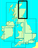
Findhorn
Courtesy Flag
Flag, Red EnsignWaypoint
57°40.34N 003°38.77W (the last known position of the old Landmark Buoy)Charts
AC 0223 Dunrobin Point to Buckie; C23 Imray Fife Ness to Moray Firth; SC 5617-8 Lossiemouth to Tarbat NessRules & Regulations
None knownHazards
The BarTidal Data Times & Range
HW Findhorn is HW Aberdeen -0135 MHWS 4.3m MHWN 3.3m MLWN 1.6m MLWS 0.7mThis site is designed for slower, roaming broadband connections, like you would get at sea, so it needs JavaScript enabled to expand the text.
General Description
Contacts
Royal Findhorn Yacht Club: 01309 690247 www.rfyc.co.uk/
Findhorn Boatyard: 01309 690099
Findhorn Pilot: 01309 690802 or 07747840916
Many sailors are put off visiting this Bay because of the bar and its fearsome reputation. This is a shame because when approached in suitable conditions the bar is not a big problem. There is no doubt that, in Northerly winds and seas, it looks very daunting; even in light winds, if there is a residual Northerly set to the sea, the breakers over the bar are very scary; but the careful mariner, with proper planning, who arrives there with one or two hours of flood remaining and no swell, will wonder what all the fuss is about. This place is no different to any other tidal choke point on our coasts, do it wrong and you’ll get caught out, plan it properly and it’s no problem.
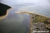
There has been a settlement here for centuries and at one stage when trading boats were quite small it was a busy little port. When the boats got bigger the trade moved elsewhere. Over the centuries there have been two or three villages, each one being devoured by the sea in its turn as, no doubt, will the present one, one day. As it stands today it is a lovely little village isolated by the MOD with its large airfield at Kinloss inland; there is only one approach from the land between the airfield and the bay which tends to give an insular feel to the place and there is no railway history here so it went from the horse and cart to the motor car with nothing in between. Fronting the bay are some very well endowed houses with picture windows looking across the bay with driveways for their cars coming in from the back and driveways for their boats going down to the water’s edge!
There is no industry apart from tourists who tend to visit mainly at the weekend unless they take up residence in one of the many holiday cottages or caravans. The caravan site used to be a Mecca for touring caravans but the owner has decided to give up the touring part of his business so that has died out. There is the Findhorn Foundation to the South of the village which hardly impinges on the village at all; its visitors come from the South, the entrance is the first habitation they come across so they proceed no further.
When you get to the village itself either by passing the Settlement or coming across the Bar you find out what Findhorn is all about; boats!! This is a small paradise for us yachties; whatever the time of day there is something going on; from a skipper sculling ashore in his tender for the papers or morning communion with nature to a full scale racing day with everything from fast Olympic class boats to Mirror dinghies, teenagers scorching across the water with the crews hung out on trapezes, Mums or Dads with toddlers, barely able to walk, handing the jib sheets of a Mirror, and even Grandads manfully attempting to show they aren’t too old for it!!
What has happened, and is still happening, is that the estuary of the Findhorn River has slowly been cut off by sand being scoured from East to West along the shore of Burghead Bay to the situation we have now, a large shallow bay which fills and empties with the tides through the narrow entrance. This inward and outward flow is strong enough to prevent the total closure of the entrance and so a sort of balance has been reached; “sort of” being the operative words because the sand is still being scoured from the beaches to the east of the entrance and it has to go somewhere so a second “coastline” is being formed outside the entrance and this will eventually close off the bay altogether but until then it is still possible to navigate a sinuous passage into the bay.
This bar does to a certain extent protect the passage inside it from the sea until you get swells in excess of about one and a half meters when it will break over the bar into the passage and make it impassable.
The bay has developed into a habitat for numerous species of birds; there are salmon and sea trout for the anglers (who need a licence), seals can be seen, there are ospreys in the forest to the West and they can be seen of an evening hunting. You cannot help but be enchanted during your stay here.
Approach
You should not plan to come in here in winds above F4 from the North.....
..... or in any sea conditions lingering after strong Northerlies. As a guide, if the wave height is predicted to be over 1.5 meters the sea inside the bar will be very iffy. Your approach should be made in the last two hours of the flood, with a shallow draft boat you can make it much earlier but for a first time visit, why make it more stressful than necessary? From this year (2018) they do not intend to lay the landfall R/W buoy so you should make for the position it was in and then proceed as below.
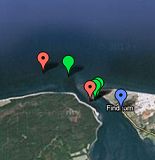
This is the end of your planned chart plotter route; the rest is by mark one eyeball as the channel into the bay is very changeable and the Fairways Committee monitor and mark it from season to season and sometimes even from month to month. Typically the first buoy will be a PHM followed by a green buoy. That PHM (the Outer Bar) will be somewhere to shoreward of the IP and that is all you can say about it; you need to look from the SW to the SE of where the Landfall buoy used to be because it (the PHM)can move as much as a mile along the coast from year to year.
There is now a series of aerial shots of the approach and directions given by the George (the pilot, photographer and sailor who goes in and out regularly) Look for this on the Royal Findhorn website at:-
Navigation 2018 amended July (rfyc.co.uk)
Caution; the "Old Bar" he refers to is the old Old Findhorn Bar a bit along the coast from the present day Findhorn Bay entrance
Obviously you head for that and on the way you’ll be searching for the green “Scaup” outer buoy. You’ll probably identify that with about a cable to go to the Outer Bar buoy; it’ll be somewhere between East and South East of that. There is only the one SHM these days (2022)
Once you have rounded the red Outer Bar Buoy you will be in the channel and if there is any northerly set to the sea you will have some white water close to your port side and will probably see white water ahead, on the other side of the channel beyond the green buoy you are heading for. It’s just a case of rounding that Scaup buoy, ignoring the threatening water to port, and keeping the three fixed pole markers to port (one of which is meant to be tide gauge but looked the same as the others in 2012 Ed Note - subsequently discovered that was because I was at the top of the tide!)) on the way to the red East Buoy at the entrance to the bay. Give the poles a good 15 metres space as the sands have drifted a bit to the West.
Most of the diagrams of the channel and the written advice gives the impression that the next green buoy is somewhere to the SE of the East Buoy at the entrance; in 2012 it wasn’t, it was north of east of the buoy and on the port quarter as the red buoy was passed!! That year it was necessary to turn round the East PHM immediately and then pass about a boats length inside the Inner Channel Green buoy. In actual fact, in 2012, it was possible to pass over the bar between the western and eastern pools in the bay with a shallow draft boat, but don’t take that for granted as there are rocks at the northern end of that dividing bar as shown in our photo.
There is a diagram of the channel in our photo gallery; this is a free hand approximation and gives only a rough idea of what the channel looked like in the summer of 2012, it most definitely is not suitable for navigation, it is not to scale, the positions of the markers are only approximate and may have been moved significantly. The main advice is to follow the buoyage in place on the day you arrive and discard any preconceived ideas of where they will be; all the cruising pilots give different advice which has been found to be misleading in parts; read them by all means but do not rely on them implicitly as the buoys can be moved at any time and may have no relationship with the diagrams in those pilots.
UPDATE 2022. It's near the end of June and they haven't been able to get out to lay the Outer PHM due to weather. From the latest satellite images that the "straight in" channel "A" is becoming deeper over the years and is a viable approach in settled weather for two hours either side of HW. Be aware that the ebb tide through the entrance is severe and after HW + 2 it will take a lot of power to get in.
Berthing, Mooring & Anchoring
There are four visitors’ buoys in the trots beyond the Boat Yard pontoon........
........(there are no berths on that pontoon.) The alternative, if you can take the ground, are the RFYC piers just outside the Clubhouse. The south side of these piers are unsuitable if there is a SW wind blowing across the Bay. There is water and an electric box at the root of the Northerly of the two piers (which has a pontoon on its North side for use by dinghies only) The RFYC is very welcoming but you will need to contact them to gain access to the electricity point so it would be an idea to liaise with them in advance of your visit.
They have no scale of charges for the use of the piers or the electricity but would like you to make a donation to their funds. It’s all very informal but your stay here will be much enhanced by your relationship with them.
Facilities
Showers and heads at the yacht club, water and electricity on the North pier only. No fuel but you may be able to purchase petrol from the yacht club if they have any to spare (they run about four outboard powered boats on race days and keep a fuel dump for them). Other than that there is petrol station 2 to 3 miles away at Kinloss which also stocks Gas and one 907Gaz cylinder
There is a small supermarket and Post Office in the village with a very good bakery next door (which also has a café with Wifi)
There is a regular bus service to Forres which has a Tescos over the bridge and roundabout at its western end. That bus service actually stops at Tescos so, if that is all you want, stay on the bus through the town centre; it’ll save you three quarters of a mile walk!
The boatyard has a café and a small chandlery; they can also help with outboard repairs.
The caravan site will allow you to use their coin-op laundrette.
Eating, Drinking & Entertainment
Two pubs both of which do excellent food but are crowded at the weekend in the summer. The yacht club has a café which can be well recommended and opens early enough to make their breakfast worth while..
They are open from about 0900 until about 1500 every day apart from Mondays and Tuesdays (their weekend) Sundays they have a lie in and open at 1000!
If you visit here in the middle of July the Yacht Club has a whole week of racing with associated fun events for the family when the tide is out and something in the club every evening (quizzes and the like)
Links
|

Got a comment to make about Findhorn ? Have you found this coverage helpful ? HAVE YOUR SAY (your email address will always be kept private)
Your Ratings & Comments
Derek Munro is the Chair of the Fairway Committee ( findhornfairway. co. uk / index.php ) and the unofficial Harbour Master and the best person to contact for the visitor moorings. 01309 690802. He will also give you directions across the bar and tell you the state of the marker buoys which are normally set to mark the shifting channels. THESE CHANGE AND NEED CHECKING.
There is a small marina at the northern end of the north - south channel parallel to the village. I did not visit it.
The older drying harbour further south has two small E/W piers and is in front of the clubhouse of the Royal Findhorn Yacht Club.
The currents are very strong and you will find the sandbanks close to your mooring at low water, but the birdlife is amazing and there are some lovely food shops in the village. morayfirth-partnership . org / findhorn-marina/
I strongly recommend visiting Findhorn and anchoring in the estuary - and get up early to see the sunrise - it is beautiful.