You are viewing the expanded version of this Harbour,
for faster browsing
use the regular version here

Waterford & Suir Estuary
Courtesy Flag
Irish TricolourWaypoint
52° 06.5N 006° 58.5W This is 2nm WSW of Hook Head to avoid overfalls in extreme weather/tide conditionsCharts
AC 2049 Old Head of Kinsale to Tuskar Rock; AC 2046 Waterford Harbour; SC5621; Imray C57 Tuskar Rock to Old Head of Kinsale (with Harbour Plans for Waterford)Rules & Regulations
The Port of Waterford’s boundary extends 6.5 kms South of a line between Hook Head and Falskirt Rock.; There is a speed restriction of 6 knots up river from Passage East; Anchoring in the fairway is prohibited except in emergency; VHF reporting points at “Bad Weather” and “New Ross” for use by Port Control VHF14Hazards
None, but be aware of the extent of the Passage Spit and the Duncannon SpitTidal Data Times & Range
Waterford City Marina; HW Waterford is HW Cobh +0053; MHWS 4.5m MHWN 3.6m MLWN 3.6m MLWS 2.4m; Dunmore East HW Dunmore is HW Cobh + 0010; MHWS 4.2m MHWN 3.2m MLWN 1.4m MLWS 0.6m;This site is designed for slower, roaming broadband connections, like you would get at sea, so it needs JavaScript enabled to expand the text.
General Description
Contacts
Waterford Port Authority VHF 14 or tel no +353 (0)51 874907
Waterford City Marina tel no +353 (0) 872384944 or +353 (0) 51 309900
Waterford “Harbour” is the generic term applied to the whole of the River Suir from the sea abeam Hook Head to Waterford City Docks and Marina; it does not include the River Barrow north of the railway bridge spanning its entrance. Within this area, starting with Dunmore East (which we have dealt with separately) there are numerous small harbours and viable anchorages which we will mention in passing as we describe the passage up to Waterford.
The Port intends to install a lifting pedestrian bridge from the North Wharf to the Merchants Quay in the vicinity of the Clock Tower. That work was due to start in July 2019 but was delayed. The work on the bridge was due to start in the autumn of 2021 but has been further delayed but may start during the winter of 2022/23
If you are exploring these waters you will find it possible to transit from one to another during a morning or afternoon gentle sail or motor much in the same way as you would in Strangford Lough. It would also be possible to make Waterford City Marina a base from which to make forays to smaller anchorages for lunch or whatever.
The city itself could take several days to explore as it has a history covering the early Viking settlement, through the various punctuation marks of Irish history from the Normans through to the present day.
On a coastal cruise of Ireland one would possibly not spend time here but on the other hand if you need a rest from unfavourable weather this is the ideal spot; the author did just that in ninety-nine when, having been storm bound in Kilmore for three days, he motored his 22 foot bilge keeler into a F4 to Dunmore then spent a week and a bit between there, Waterford, New Ross and Ballyhack before an overnight dash (more a “plod”) back to Milford; apart from the trip over from Milford and the trip back the wind was never below a SW F4 so this estuary saved his holiday!
Approach
Tidal Stream Information
Outside the entrance of Waterford Harbour
West going stream begins -0100 Dover or (+0450 Cobh)
East going stream begins at +0515 Dover (-0120 Cobh) The external spring rate does not exceeding 1 kn
Inside the Waterford Harbour estuary:
The flood begins at +0210 Dover (-0425 Cobh).
The ebb tide at -0505 Dover (+0045 Cobh).
Strong tides of up to 3 knots inside the estuary following the channels
You are going to have fun working out favourable tides on passage to pick up favourable tides going up the estuary; the likelihood is that when you get to Dunmore East you will have to anchor up and await favourable tides up to Waterford although under some conditions you may have enough flood left to make it to Duncannon or Passage East/Ballyhack.
The link to the seven day forecast for tides at Cheekpoint is top right labelled Admiralty. For rough approximation HW Dunmore is about twenty minutes earlier than Cheekpoint and Waterfor itself is twenty minutes later.
Ideally you would aim to reach the corner at Hook Head or Dunmore East at LW slack and have the whole of the flood to play with up the river. In reality you will have used a lot of the favourable tide off the South Coast to get there and will find that there is little left to take one up river;going up against the ebb is pretty well a non-starter as it can run at up to 3 knots at Passage East.
If you are coming from the East and arrive whilst the ebb is still running out of the river you should be prepared to carry on well to the West of Hook Head to avoid the overfalls before turning in to the estuary but on the other hand, if the flood is running you can cut in as tight as you like to the Head in settled weather as it is steep to.
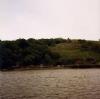
Coming from the West you should keep clear of Falskirt Rock and Robin Red Breast Rock (should be no problem as they are fairly obvious). Depending on the weather you can choose to drop anchor in either Dunmore Bay (discussed in our Dunmore East notes) or across on the East side of the estuary at either Lumsdin’s Bay, Templetown Bay or Dollar Bay.
Further up on the West side the shelter of Creadan Head looks inviting and it would be ok for a short stop but if the wind is coming up the estuary you are likely to find that the swell there can set across the current/weather leaving you beam on and rolling all night; you wouldn’t thank me for recommending it! There are anchoring possibilities at both Duncannon and Arthurstown on the East side on the way up but the shellfish beds there make that a bit awkward these days and, anyway, Duncannon is a bit open to the North and North West and there is a strong back eddy in the tide here; also be careful of the submarine cables.
If you can make it up to Passage East before the ebb starts then this is a really good option, that or Ballyhack on the other side. You will have to be able to dry out if you want to go inside either of these and the density of local boats may prevent that. Using the outside of the SW harbour wall at Ballyhack is possibly the best option but it is hemmed in by the ferry pylons and it will be tricky getting alongside on the ebb without ending up against the slip. (When did you last have to practice the art of “ferry gliding”??). If going inside at Ballyhack you should note that there is a ledge poking out beyond the end of the SW harbour wall for about five meters and it is covered from half tide onwards.
If you can take the ground then Ballyhack is a good place to plan a stop for a couple of days; it has a shop, a good pub which does food and its Norman Keep to explore (you will be unlikely to escape from here without experiencing the guided tour). There is also quite a large boat yard if you are in need of repair.
That’s about it for actual harbours on the way up; there are anchorages at Seedes Bank and Buttermilk Point but there are shellfish beds close in at Buttermilk point so you will have to anchor quite a way out or to the North of the Point. It is said that the Campile River is good for an idyllic day’s outing in the dinghy there being lovely scenery and a pub at the end, but you would need an outboard or a strong back for that (and work the tides).
There is a small harbour a couple of cables to the West of Cheek Point which dries to mud and has a narrow channel into it from the ENE which has two pairs of buoys as markers. You could berth here at the outer end of the pier for a couple of hours for a pie and a pint at the pub. Interestingly this village differs from the Irish norm in that it has a pub & a restaurant but no shop or church!!
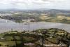
Continuing up river from Cheek Point the next place of interest is Little Island; how this island came about looks puzzling as it’s almost as though the main channel (Queens Channel) could have been man made but is more probably the result of retreating glacial action at the end of the last Ice Age (Ed Note – pure conjecture by the author!). How ever it was made, there exists a narrow channel of varying depths around the island to the South of the main river and, with careful navigation, a small yacht can make passage through it and find little spots to anchor away from the madding crowd. NB Our Member's comment (below) reference the depths here. The problem will be that at low water the shore dries to mud which makes boarding a little difficult unless one has found dry ground to land on. Unfortunately there are no waterside pubs on this stretch of the river.
And so to Waterford itself. As has been said, Waterford has a history going back to Viking times and before and is probably Ireland’s earliest major harbour. On passage up river past Cheek Point there is ample evidence of this on the North bank of the River as there will be large vessels tied up at the various commercial quays for bulk cargoes, containers and finally at Waterford itself, opposite the city Pontoons which lie along the South bank...
The only thing you need to note is that at springs the ebb through here can be up to 3kts, you need to take care coming alongside and have your warps ready to put ashore so that you don’t drift down on to neighbouring boats.
Berthing, Mooring & Anchoring
The various options have been discussed above. When the new pedestrian bridge has been built the Superintendent envisages that he will park masted vessels down stream of it to save the hassle of lifting the bridge. He requests that skippers intending to visit contact him on one of the numbers above

The only place you will have to pay harbour dues (apart from Dunmore East) is at Waterford where the charge (2019) for a 10m boat remains at 20 Euros per night with reductions for three and five night stays (45 and 95 Euros).
Facilities
All services are available on the pontoons at Waterford (shore power is on prepayment cards) along with showers (free), toilets and a laundrette(coin op) ashore. Petrol and diesel can be obtained in cans at a local filling station about twenty minutes walk away and Gas/Gaz refills can be found in a hardware shop close by. That’s about it; you will be pushed to find anything on the trip up to Waterford apart from very basic provisions at Ballyhack or Passage East so you need to make sure of your fuel state before you go past Dunmore East. Since we were last here they have gotten Wifi on the pontoons
There’s a boat yard at Ballyhack and further similar facilities at Waterford.
Eating, Drinking & Entertainment
Apart from the small anchorages you’ll find good pubs ashore all the way up the estuary and when you reach Waterford there’s everything including an Opera House (more Nashville Operee than Covent Garden!). It would of course be a shame to get all the way here and not spend some time at the Waterford Glass Company; for information on this and other diversions go to:-
Links
|

Your Ratings & Comments
Got to the Hook, which marks the entrance to Waterford Harbour, 90 mins earlier than planned after sunny, calm gybe, with one reef, down the coast, filled with long, long sandy beaches and low-lying land.
Passed recommended anchorages (sandy beach of Dollar Bay at Broomhill Point, and Buttermilk Point opposite Cheek Point, with old wooden fishing boat wreck on mud).
Lovely safe anch in kings channel above the wire ferry. depths after the ferry seemed lower than charted where i sampled them.