It's not something we typically cover on visitMyHarbour . After all, most of us are more interested in harbour guides, tides, passage planning and local weather. But our conversation sparked a question: where did the Shipping Forecast come from, and why has it remained such an important part of maritime life for more than 160 years?
What started as a quick chat turned into a fascinating dive into maritime history.
The disaster that changed weather forecasting
The story begins with the loss of the Royal Charter in October 1859. Returning from Australia, the passenger ship was caught in a severe storm off the coast of Anglesey and wrecked near Moelfre. More than 450 people lost their lives, making it one of Britain's worst maritime disasters.
The tragedy highlighted the need for better weather information for mariners and helped drive support for a national storm-warning system.
Robert FitzRoy and the origins of marine forecasting
The man at the centre of this story was Vice-Admiral Robert FitzRoy, founder of the Meteorological Office, now known as the Met Office. FitzRoy had already begun collecting weather observations around Britain's coastline, but the Royal Charter disaster strengthened his case for organised weather forecasting.
In 1861, Britain introduced its first storm-warning service. Warnings were transmitted by telegraph to coastal stations, where signals were displayed to warn vessels of approaching bad weather.
Those early warnings laid the foundations for the marine forecasting services sailors rely on today.
What is the Shipping Forecast?
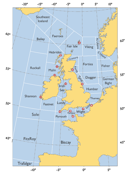
Produced by the Met Office and broadcast by BBC Radio 4, the Shipping Forecast provides a marine weather forecast for the seas surrounding the British Isles.
Instead of focusing on towns or harbours, it divides the surrounding waters into sea areas with names that have become legendary among sailors:
- Viking
- Dogger
- Cromarty
- Humber
- Thames
- Portland
- Plymouth
- Fastnet
- Biscay
For each area, the forecast provides information on:
- Wind direction
- Wind strength
- Weather conditions
- Visibility
- Sea state
This allows mariners to build a picture of weather conditions across a much wider area than a local forecast can provide.
If names like Dogger, Fastnet and Cromarty leave you scratching your head, this short video from the Met Office explains the history of the Shipping Forecast, how it works and how to make sense of its unique language.
Why the sea area names matter
Part of the Shipping Forecast's enduring appeal lies in its distinctive geography.
Many of the sea-area names are rooted in maritime landmarks, fishing grounds and geographical features. Dogger refers to Dogger Bank, a vast sandbank in the North Sea that has supported fishing fleets for centuries. Fastnet takes its name from Fastnet Rock off the south-west coast of Ireland, known to sailors around the world as a key waypoint in the famous Fastnet Race.
For generations of mariners, these names have become synonymous with the waters around Britain and Ireland.
Understanding the Beaufort Scale
One phrase you'll often hear in the Shipping Forecast is:
"South-west 5 to 7, occasionally gale 8 later."
These numbers refer to the Beaufort Scale, which measures wind strength.
| Force | Description |
| 4 | Moderate breeze |
| 5 | Fresh breeze |
| 6 | Strong breeze |
| 7 | Near gale |
| 8 | Gale |
Even in the age of weather apps, understanding the Beaufort Scale remains a useful skill for anyone spending time on the water.
Does the Shipping Forecast still matter?
Modern sailors have access to tools such as Windy, PredictWind and detailed digital forecasts from the Met Office. For local conditions around a harbour, these often provide more detailed information than a radio broadcast.
Yet the Shipping Forecast still serves an important purpose.
Rather than focusing on a single location, it provides a big-picture view of weather systems across the seas surrounding the British Isles. For coastal cruisers, offshore sailors and passage planners, that wider perspective remains valuable.
Rather than replacing modern forecasting tools, the Shipping Forecast works best alongside them.
More than a weather forecast
Perhaps the Shipping Forecast endures because it is more than a practical marine weather forecast.
Its familiar rhythm, distinctive sea-area names and longstanding connection to Britain's maritime heritage have made it a cultural icon. Whether you're crossing the English Channel, waiting for the tide to turn or simply listening at home, there's something uniquely evocative about hearing those famous names read out across the airwaves.
That may explain why so many people who never set foot on a boat still find themselves listening.
Final thoughts
The Shipping Forecast may not be the first thing many of us check before leaving the harbour, but its influence on British boating is undeniable.
Born from a desire to prevent tragedies at sea, it helped shape modern marine weather forecasting and remains a trusted source of information for mariners today.
And while Trevor and I won't be setting course for North Utsire any time soon, we'll certainly listen with a little more appreciation the next time we hear those familiar names drifting from the radio.
Further reading:
- Met Office: Shipping Forecast guide
- Met Office marine and coastal forecasts
- BBC Radio 4 Shipping Forecast
- Royal Museums Greenwich: Robert FitzRoy
Image: Emoscopes, CC BY-SA 3.0, via Wikimedia Commons
Planning your next harbour visit?
The Shipping Forecast provides the big picture, but local knowledge is just as important. Explore visitMyHarbour 's harbour guides for details on facilities, visitor berths, navigation notes, local attractions and more.