Confused about what we sell and do? Un-confuse yourself !

Find the amount of information around this site overwhelming ?
Quick links: Tide tables Harbour Coverage Membership Buy and Keep "For Nav" products: Android: Marine Navigator Charts "Turn Key" Android Chartplotters Unified Charts
Getting confused about the things we do, make and sell ?
We'll try and un-confuse !
"If you have a yen to get out there on the sea, all we can say is stick with it, learn all you can and then go and try it. Seafaring is a fantastic and healthy pastime, there's so much to learn, and so much fun to be had. Adventures to be had and friendships to be forged...
In the kind of sanitised politically correct lives we' re forced to lead now, getting out to sea is the one great adventure left to us... It is a place where actions have consequences, and responsibility can't be avoided"
For interested beginners WE SAY read on, browse the site, pick up what you can and take it in. For some entertainment you could start HERE for some amusing videos.
Or HERE if you ever wonder about living the life of Riley on your boat in the Med
For those of you with boats ...
So much depends on the type and style of seagoing:
For those who own a boat and sail/motor in fair weather around a certain fixed limited area, say a range of 1 daysail (50 miles max), and have no time or aspirations to go further...
Recommended products/services: our free online monthly tide tables... and just browse the site freely
For those who venture further afield afloat, or have aspirations to, some of what we do will be of use. First they can check out our free harbour coverage and get some idea of places they might visit. They could buy cheap Imrays small scale charts covering a wide area to get the overview and navigate on as they move around the coasts.
Likewise those with trailer boats, Kayaks, Canoes, dinghies who trail to new destinations...
If they are members, they can use the online full screen charts to investigate possible anchoring/mooring/launching/daysailing places in far more detail than a small scale chart can provide. Members can also download our harbour coverage as PDFs for offline use.
"I have been very taken with the online charts of UK waters available from a website called VisitMyharbour. It gives access to JPG versions of all current UK and Irish waters' charts for £25. I have been building up a set of chartlets for the English Raid in July... ... I am really quite impressed" Julian Swindell...
3. Again using our charts draped over Google Earth satellite images with variable transparency, members can get an astoundingly accurate idea of what they are likely to encounter on their cruise.
Recommended products/services:
- Use the FREE harbour coverage/chartlets for planning
- Use the Free tide tables and tidal stream charts for planning
- Join for for a one-off fee of £25 and fully research potential passages and stopping places from our massive collection of online charts. Membership does not expire. Investigate and plan using our online streaming Google Earth compatible charts too. Find out more
BEST SELLING "For Nav" OFFLINE CHARTPLOTTING PRODUCTS
Tablets are getting popular for a GPS navigation tool...far more popular than laptops
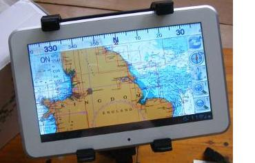
We make packages that work with Marine Navigator app on Android tablets
See the chart coverage and prices.,
Chart packages start at £8.99 for members (£14.95 non members) for a complete set of UK-IRL charts. Other continental areas available...
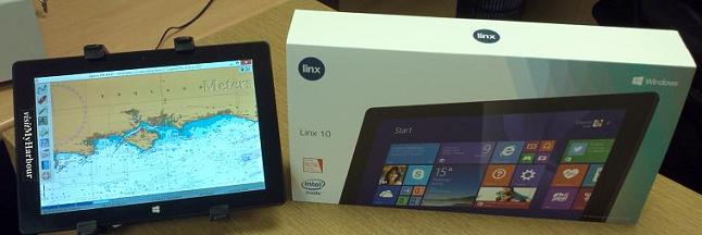
Windows
Portable Charts that work with OpenCPN, SeaClear, qtVlm, Polar View and for racers Expedition:
Unified Charts
Recommended products/services:
- Use the FREE harbour coverage
- Join as a member (one off fee £25) for all the advantages mentioned further above. Find out more
- Buy our one of our "For Nav" GPS chart packages above and use at sea for electronic navigation, Windows or Android (members get these at a huge discount)
PS: We know that our chart packages are already being used for some very diverse purposes (apart for the 8000 odd we've already sold for in use on leisure craft, since 2012)
- Buoy and mooring laying operations around rivers and harbours
- On windfarm boats
- By Ships Pilots
- By commercial fishermen
- By Ships Captains in their own cabins, keeping an eye on things
- Building a historical database of lobster pot positions and catches
Article Info
Related articles