 Rosslare Europort & Rosslare Strand
At a Glance
Download Guide
Contacts: Rosslare Harbour Operations VHF 12 tel no +353 (0)53 9157929
This harbour is not set up to deal with visiting
yachts; it is owned and run by Irish Rail
(Iarnród Éireann) for the sole purpose of
servicing the various Ferry Services which use the port as a
terminus. It has a separate quay (Fisherman's Quay) to deal with
fishing vessels which may also be used by visiting yachts for a
quick overnight stop over, or in need of shelter but the yachtsman
is at the bottom of the pile here and you should not leave your
boat unattended at any time in case the harbour needs you to move
to accommodate another FV.
The entrance to the harbour points NW and is very wide; any strong
wind from the Northern quadrant produces adverse conditions inside
the harbour and it is untenable for a small yacht (must be a
nightmare getting one of those large ferries docked, stern to,
under those conditions). On the other hand it is well sheltered
from SW gales and would provide a much needed relief if you've been
caught out coming across St George's Channel.
If you have arrived here in fairly settled conditions with no
threat of a build up from the north then you'd probably be better
off going past Rosslare Europort itself and anchoring off Rosslare
Strand three or four miles to the NW but watch out for fish cages
there. If you do choose to anchor there you will find a Lifeguard
Lookout where you can land your dinghy and the tidal range is very
small (about a meter and a half).
Rosslare Europort & Rosslare Strand
Approach
The main consideration in any navigation round here is the tidal streams
The Irish sea empties and fills up through St George's Channel
at rates in excess of three knots in places; there are back eddies
between the offshore sand banks and the mainland which can span
most of the tidal period and make a mockery of ones planning. A
good example of this is through the North Shear (inside the Long
Bank) where the tide sets South for ten hours of the cycle starting
two an a half hours before HW Dublin an turning North four and a
half hours before the next HW Dublin whereas a few miles North of
that it's back to a six and six cycle, the Northbound current
starting four hours after HW Dublin, likewise in the channel to the
East of the Europort where it is NW for six hours and SE for six
hours. Another point that needs noting is that the streams are not
parallel to the sandbanks, setting NE/SW across them. It's
complicated little corner with very little in the way of tidal
information on the chart.
From the North it's easy; you can come down inside
the Long Bank and Holdens Bed to slip into the harbour just to the
East of the No 3 buoy. From the South will depend on the weather
and sea conditions; it is perfectly feasible to cut the corners
inside the Tuskar Rock (that passage is 2miles wide) or even inside
the Bailies where you can cut close inside the Fundale Rock PHM but
avoiding the Collough Rock and then pass between the Splaugh PHM
and the Splaugh Rock. What short cuts you take depends on your
navigation instruments and the sea state because in conditions of
wind over tide the area between the Tuskar Rock and the mainland
can become awesome.
If you are coming from the East then as well as everything else you
have the TSS to deal with; theoretically when crossing a TSS your
boat's head should be at right angles to the direction of the TSS,
which is all very well, but it so happens that direction of the TSS
here is parallel to the tidal streams through the St George's
channel so, if you obey the rules, you could leave the TSS four or
five miles down stream of where you entered it; if you haven't
compensated for it in your passage plan you could well end up with
the Tuskar rock on the bow instead of on the beam!! Keep it in
mind that pretty well all the ferries departing from here will cut
in close to the East breakwater to set heading SE so you should aim
to pass well clear of that area when making an approach to the
harbour.
Euro GMT
Waypoint
Charts
Rules & Regs
Hazards
Tides
Berthing
Anchoring within 3 cable of the harbour entrance is prohibited and
...... there are no moorings available so your only option is to mix it with the FVs on the Fisherman's Quay.
Note: It's been reported in May 2013 that a drying sandbank has built up against the No 4 berth in Europort, see below.
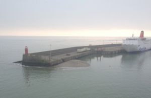
There is a small harbour half a mile to the west of the Europort but it is unsuitable for yachts being already overcrowded with small angling vessels and dries at LW. In settled conditions it is recommended that, of all the options, you anchor off Rosslare Strand and land by dinghy at the Lifeguard Lookout; it will be unsuitable there in winds from the Northerly quadrant but then again, in those conditions, the Europort itself is unsuitable so unless the wind is howling off the shore (the land is very flat here) your best spot is that anchorage.
The Google O/H link below shows the location of the Lifeguard
Lookout on the Strand.
An alternative anchorage in NW weather is 5 nm South of the Europort at Carna in St Margaret's Bay but the hinterland is very flat around here and if NW gales are threatened you'd be much better off in Kilmore Quay
Facilities
Rosslare Strand is a popular holiday beach so most of what you
need is there and, if you are alongside in the Europort, that has
all the facilities you would expect of a major port whilst
provisions can be found in the village close by.
You should note that in the Europort you will be inside the
security zone which will restrict your access a little.
Chandlers
What to Do
There is not a lot in the village behind the Europort; a few pubs and shops but at Rosslare strand there are plenty of eateries and good pubs which can found at the site below.
History
Local Business
Tide Information for Rosslare Europort
October 2026
Please note: It is the user's responsibility to ensure that the data is suitable for their intended purpose. VisitMyHarbour must not be used by vessels for navigation.