 Crouch (River) inc Burnham and Fambridge
At a Glance
Download Guide
The River Crouch in the approaches and the first few miles inland is flat and featureless and not particularly attractive.
Nevertheless Burnham on Crouch has been popular as a centre for racing sailboats for a long while.
The wide open expanses of water with nothing to block the wind, combined with the River Roach diverging off at right angles can offer a variety of courses for those interested in racing keelboats and dinghies. For cruising types perhaps the area is less attractive, the scenery fairly bleak and the only town of consequence Burnham on Crouch is small by any standards.
The big problem is unless you are in Burnham Yacht Harbour provisioning and stores are unlikely to be straightforward. There are a few marinas along the river, together with a couple of places where you could anchor.
It should be noted that the overall authority for navigation on the Rivers Crouch and Roach is the Crouch Harbour Authority. They do charge Harbour Dues on top of whatever the various marinas charge but there is a "First 14 day free" allowance which should cover any visitor.NB This used to be 28 days and has been reduced to 14. They control all the cargo ship operations and should you have any query they can be contacted on VHF #11
Certain areas are set aside for waterskiing, but the rest of the River has an 8 knots speed limit.
The river can be followed inland to Battlesbridge by the intrepid skipper of a shoal draft craft, and the scenery does improve in the upper reaches. Most boat problems can be handled in this area, and there is a good rail link to London.
This video from Dylan Winter will give you a feel for the Crouch and Roach
Crouch (River) inc Burnham and Fambridge
Approach
Approach to the River Crouch is made via the Whitaker channel which runs between Buxey Sand to the North...
... and Foulness Sands to the South. Anyone contemplating shortcuts over these sands should be aware that they are concrete hard, in common with the other sands of the Thames Estuary. They are not the places to go aground on the leeward side. Local information is that the Foulness Sands are best avoided as there are many uncharted obstacles and there are no recent surveys
The initial approach is made from a red and white buoy, Swin Spitway (Iso.10s). If coming from the East beware of the Gunfleet Sand laying to the north-east of this buoy, approaching it when it bears due West clears this. If approaching from the River Blackwater area the spherical red-and-white Wallet Spitway (LFl.10s) is identified and a south-easterly course brings you to the Swin Spitway Buoy. More pilotage directions follow:
If approaching from the Southend area via the Middle Deep or East Swin channels (which run parallel to one another, divided by a shallow patch) a swing northwards can be made once abeam the Maplin Approach Buoy (FL(2)G.10s) which will bring you to the Swin Spitway Buoy. NB The S.Whitaker green buoy has been removed.
If you have come out of the Thames you must remember that you will have used most of the ebb and be turning round to come up the Crouch with the flood and thus will be swanning about around these shallows at Low Water. The same is true if you've come out of the Blackwater. On the other hand if you've come down from somewhere like Walton on the Naze then you can utilize the Thames flood and just reserve the last couple of hours for the run up the Crouch. Whatever your plan you have to watch the timing because if you arrive at Foulness at HW you might as well just drop the pick and wait for the next flood
IMPORTANT The buoyage was improved here in 2011 so, if it's been a while since you were here last, make sure you have an up to date chart
A study of the charts (but, as noted above, there is much on these sands which is not charted) will show that the approaches described are cautious, and that there are various shortcuts that could be taken given a suitable rise of the tide. From the North the Ray Sand Channel can take you across Buxey Sands, while if coming from the Southend area a shortcut could be taken across the Whitaker Spit by leaving the Whitaker Beacon,(an unlit isolated danger mark) on your port side. Whichever approach you choose remember the hard sand, and that in a flat and featureless area like this it is essential to follow the buoyage in the correct order. It is easy to mistake one buoy for another with unpleasant results so work your courses out across the charts in advance and never assume the identity of buoyage without positively verifying it. A series of carefully checked waypoints would serve well here.
From the region of the Swin Spitway Buoy(Iso.10s) or the Inner Whitaker(SCM), it is a run in of another 9 miles odd to enter the River Crouch proper on a generally south westerly course. You can take the Whitaker Channel using the twinned Red/Green buoyage or run in North of the Swallowtail Bank using the yellow Swallowtails 2,3 & 4 as PHM to arrive between the Buxley Edge (Fl.G 10s) and the Swallowtail No 4 (Fl(2)Y 10s). There is a shallow patch ahead, the Sunken Buxey, which has 0.7 m over it at CD and can be passed to the North or to the South. It is guarded by two cardinal buoys, Sunken Buxey to the North (northerly Cardinal Q) and Buxey No.1 to the South (southerly Cardinal VQ(6)+LFl.10s). If you have come in through the Whitaker channel it's just a case of following the paired buoys to the Buxey No1(SCM) and leave it to starboard; if, on the other hand you've entered north of the Swallowtail bank and want to pass to the north of the Sunken Buxey be very certain that you correctly identify the Swallowtail W WCM and the Sunken Buxey NCM - or, of course, if you are sure of your draft and depth you can swan straight over the Sunken Buxey towards the Buxey No2 (NCM)!!
After the Sunken Buxey you pass the Buxey No.2 (Q) a NCM which you leave to port, then between the Outer Crouch pair (Nos 1 & 2) and the next Outer crouch pair (Nos 3 & 4). The next buoy (the Crouch NCM) can be passed either side with the deeper water lying to the north of it (leave to port) followed by the Holliwell Point green conical buoy and the spherical red-and-white Inner Crouch safe watermark (LFl.10s) which again can be passed either side and you are now in the River proper with land either side of you.
If making a night time entry note that the Whitaker channel buoys (1 through 8) follow a logical sequence of one flash, two flashes, three flashes etc and are synchronised to flash together, which, on a clear night, must be quite something.
I can't imagine what it must have been like in the old days before GPS, Decca or RDF, feeling your way into here in low visibility with just a leadsman in the bows
The harbour authority here provide some useful information in their website, a link to which is provided below:
They also have a downloadable guide for the whole river which you can download in pdf format below
https://crouchharbour.uk/wp-content/uploads/Crouch-Harbour-Guide-2026.pdf
£ GMT
Waypoint
Charts
Rules & Regs
Hazards
Tides
Berthing
The visiting yachtsman or motorboater will find Burnham Yacht Harbour and Essex Marina in the immediate Burnham....
..... area while deeper within the river, Bridgemarsh Marine and
Fambridge Yacht Haven offer drying and floating berths. Anchorage
is a possibility too (if a little faint). Full details and prices
are now covered:
Once you are in the River the deepwater runs fairly centrally and a
generally westerly course will bring you towards Burnham. In season
many spherical yellow racing buoys are laid and the first few of
these you will see on your starboard side going up River.
The River Roach branches off to the South just past the red can
buoy guarding the wreck of the Pinto and near the Branklet R/G/R
buoy (Fl(2+1)R.10s).A good anchorage can be had just within the
Roach as shown on the chart and If heading here leave this buoy
close to starboard as you turn into the Roach as a shallow spit
extends from the Eastern Shore. Otherwise leave the Branklet R/G/R
buoy well off on your port side and continue up River.
For more information on the River Roach and its anchorages see
elsewhere on this website at
http://www.visitmyharbour.com/harbours/east-coast/roach/
The following link shows speed limit areas in the Crouch:
http://crouchharbour.uk/byelaws/speed-limits/
Unless you are a deeply laden coaster Horse Shoal shouldn't be a problem. If you want to do everything by the book leave the northerly Cardinal buoy Horse Shoal (Q) to port and then the green conical Fairway No.1 buoy (Q.G) to starboard. Otherwise simply make your way from the Branklet Spit Yellow buoy to the green buoy mentioned above, leaving the northerly Cardinal off on your starboard side. A shallow patch in the River shortly after the green Fairway No.1 buoy (Horse Shoal) is left on your starboard side as you keep to the southern side of the River. This shoal with 0.6 m over it at CD can be safely ignored with a suitable rise of tide.
Moving further in the Green buoyage indicates that the deeper water is on the southern side, but the average small craft can use most of the width of the River.
An electricity cable crosses under the River just after the Shoal and is marked by posts on the shore and a series of four spherical yellow buoys. Anchoring is not allowed anywhere near here, or in the fairway for that matter.
To the north of the fairway as marked by the Green buoyage there are numerous swinging moorings off the town of Burnham on Crouch. These are either maintained by the boatyards or the yacht clubs, and it may be possible outside of Burnham Week (end of August) to use one. Check the directory for contact numbers, or pick up a suitably sized vacant mooring and promptly dingy ashore to check out the score.
It would be hard to find anywhere to anchor in this area out of the channel and clear of the moorings, and if tacking around in the River be aware of the tide can flow at 3 kn through the moorings..
Perhaps the first noticeable building as you approach Burnham would be the big white clubhouse belonging to the Royal Corinthian Yacht Club, followed by the town itself and then Burnham Yacht Harbour set in an excavated area and entered through a channel. On your port side you will see the long pontoons of Essex Marina jutting out into the River itself.
Burnham Yacht Harbour.
If planning to use Burnham Yacht Harbour it's best to call them in advance on VHF channel 80 (callsign Burnham Yacht Harbour) or telephone 01621 786832. They don't have any specific visitors berths so get instructions where to park. Berthing is normally to a finger pontoon. A link to their website is provided below:
http://www.burnhamyachtharbour.co.uk/
The entrance to the dredged channel through the mud is marked by a
yellow buoy with an X topmark. (Fl.Y.5s) and it is important to
pass this buoy closely. Make directly for the entrance towards the
big blue boatshed and pass between a pair of substantial piles, the
port side pile being lit Fl.R.10s, and starboard side pile being
lit Fl.G.10s. You can access the pontoon plan HERE
Access is available 24 hours and all normal Marina facilities are available including water and electricity on the pontoons, toilets and showers ashore with WiFi available throughout. There is a fuel berth for diesel with tight access. Calor gas and camping gas are available and there is a Chandlers and pub/restaurant on-site. The 35 tonne travel lift can cope with most yachts and there is also 100 tonne slipway. WiFi is available. They also have an arrangement with a local sailmaker who will collect any sails needing attention.
Prices (2022) come out at £3.10 per metre per night, with discounts for club bookings.
The site is close to the town for provisions, pubs, restaurants, and banks. There is a direct rail service to London from Burnham.(Station is about 15 minutes walk away)
Essex Marina.
This is on .png) the other
side of the River slightly upstream from Burnham Yacht Harbour. It
consists of two pontoons running along the river, an inner and an
outer one with entrances at either end. A walkway joins the
pontoons to the shore so that the whole arrangement looks like an H
laid sidewise.
the other
side of the River slightly upstream from Burnham Yacht Harbour. It
consists of two pontoons running along the river, an inner and an
outer one with entrances at either end. A walkway joins the
pontoons to the shore so that the whole arrangement looks like an H
laid sidewise.
The outside edge of the outer pontoon (Riverside
berths) provides alongside mooring for larger craft. The inside
edge of this pontoon and also the inner pontoon have finger berths
at 90° to the flow of the river. This could make berthing in strong
cross tides interesting. You can access a chartlet of the marina
pontoon plan with this link
https://www.essexmarina.co.uk/assets/poontoon-map-
Contact the Marina on VHF channel 80 or telephone 01702 258531 to arrange a berth here. If they intend to berth you anywhere other than on the outside edge of the outer pontoon you will need to find out whether you need to enter the cul-de-sacs from the East or the West side. A link to the Marina's website is provided below:
The charges here in 2019 were £2.26 per metre per night and we are awaiting their prices for 2022, there is 24-hour access and bookings are taken. All normal Marina facilities are available here with water and electricity (charged on metred usage if lengthy stay) on the pontoons, toilets, showers and laundrette ashore. For the boat petrol and diesel are available from the fuel barge at the western end of the pontoons, there is a 70 tonne travel lift and a 100 tonne slipway. New chandlers are on site from April and Calor gas & Camping gaz 907 is available.
This Marina has recently been purchased by a company that specialises in selling powerboats, and is used as a showcase for their products.
The Essex Marina Yacht Club is located here and the bar restaurant is open at lunchtime and in the evenings. There is a further pub on the sea wall just upstream. Apart from these however there is not much in the way of facilities, no stores no banks.. nothing. It's not as bad as it sounds however because you can either dinghy across to Burnham, or there is a ferry to the Town Quay, where all small town facilities will be found.
Just upstream of the Marina is the Baltic Wharf commercial timber jetty. These are in fairly steady use by small coasters delivering timber.
Burnham to Battlesbridge.
If planning to continue up River you will find the character now changes and scenery starts to become more rural. There are a couple of further mooring and anchoring possibilities for even deep draught boats as far as Fambridge. Day-to-day facilities are a bit thinner on the ground now too.
After leaving Burnham behind and heading north westwards up Cliff Reach (taking note of the shallows that radiate out from the North Eastern Shore in the region of green conical buoys numbers 13 and 15, leave to starboard) the deepwater is fairly central. A low cliff on your starboard side can provide some shelter if there are strong winds from the North East, and anchorage is possible. The ground is foul close in under the cliff so stay in slightly deeper water if anchoring.
At the top of Cliff Reach the main run of the River swings to the South West around Bridgemarsh Island, while a buoyed creek runs to the North of the island. A large red beacon (Fl.R.10s) marks the point where Althorne Creek branches off to the North. If intending to carry on up the Crouch to Fambridge, leave this beacon well off on your starboard side as the best water is nearer to Black Point.
A small Marina is established in Althorne Creek and is accessed via the buoyed channel running to the North Bridgemarsh Island. Getting here involves leaving the above-mentioned red beacon to port and following the channel.
Bridgemarsh Marine.
They now have a visitors pontoon here, equipped with shore power and water. Contact Bridgemarsh Marine on VHF channel 80, or telephone 01621 740414, mobile 07859 957719. Access is available for 4 hours either side of high water, the area being more suitable for shoal draft craft. All berthed visiting craft must be prepared to touch the bottom at LW.
They now have a website https://bridgemarshmarina.co.uk/
Facilities here includ e
water and electricity on the pontoons, showers, toilets, and
laundry ashore. Calor gas (but no Camping Gaz) is available and
there is an 8 tonne crane and the slipway. Normal boatyard services
are available. Diesel is not available.
e
water and electricity on the pontoons, showers, toilets, and
laundry ashore. Calor gas (but no Camping Gaz) is available and
there is an 8 tonne crane and the slipway. Normal boatyard services
are available. Diesel is not available.
They have a boathouse/clubhouse bar and restaurant which used to
serve good food and beverages and good railway connections from
Althorne Station to London via Wickford.
They are in the process of a moderate makeover, improving the pontoons and shore facilities. This was started during lockdown and is still under way and not expected to be completed until the end of August 2022. Check with them before planning a visit.
River Crouch to Fambridge.
If continuing up the Crouch you will leave Bridgemarsh Island on your starboard side and carry on through the fairly deep water of Easter Reach and Raypits Reach. This is one of the areas with de-restricted speed limits.
Pushing on with a minimum of 3 1/2 m at all times you will come to the moorings laid at Fambridge. These are administered by the Marina, and it is possible to find an anchorage in deepwater above or below these moorings. Landing is possible on the North bank.
Fambridge Yacht Haven.
http://www.yachthavens.com/fambridge/
This is now owned by the Yacht Havens Group and comprises of the old Fambridge North Yacht Station and what was the old West Wick Marina covered by the name Fambridge Yacht Haven
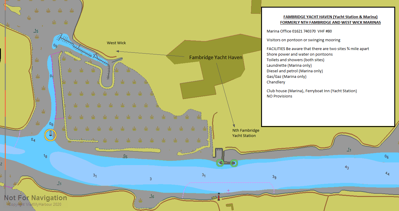
This yacht haven maintains 120 deepwater moorings, 180 berths on
pontoons with 24-hour access, and they can also offer serviced mud
berths for larger craft such as Thames barges and Dutch
barges.
Visitors can be accommodated on the long pontoon
on the North side of the main River or in the marina up Stow Creek
which has been dredged to allow access HW +
4 hours
Contact the Marina on VHF channel 80, or telephone 01621 740370 to arrange a berth or a mooring, or you can simply tie up to the visitors pontoon on the river and wander ashore to the office. There are full facilities at either the Yacht Station or the Marina.
The cost here (2022)has increased to £3.50 per metre. whilst swinging moorings are substantially cheaper at £2.00 per night.
All the usual Marina facilities are available with water and electricity on the pontoons, toilets and showers ashore. Diesel is available and there is a 40 tonne slipway hoist. The marina has its own cafe/bar at the Stow Creek site. The good news is that the Ferryboat inn has re-opened.
Provisioning is a problem as there is no local shop but there is a pub and a club. The local station is on the same line as Althorne and Burnham, thus providing good connections to London.
Should you need to enter Stow Creek you will find it lays about half a mile away from Fambridge on the North side. It is marked by a beacon with a 4 kn speed limit sign on it, and this beacon should be left to port.(Check with the Marina about this as the charts and the photographs show the beacon in different places) The channel is then marked by small buoyage and a set of lead in lights (white over white) to the Marina berths. It should be accessible other than at dead low water.
Upriver to Brandy Hole and Beyond.
After passing the facilities at Fambridge and Stow Creek the River swings to the South West into Brandy Hole Reach and now becomes quite a bit shallower.
Brandy Hole Reach is a de-restricted speed limit area in use by water skiers in the summer.
Swinging to the West once more you come to an area with lots of moorings and the pontoon of Brandy Hole Yacht Station. Many, but not all, of the moorings in this area dry out at low water. If you require a visitors mooring here contact Justin Curtiss on 07788 470718; he will advise on what is available and direct you to a mooring suitable for your draft. The pontoon here is owned and operated by the Yacht Station and what used to be the Brandy Hole Yacht Club is now a restaurant which only opens for bookings so berthing enquiries should be directed as above. An overnight mooring will cost around £15.
Although the River dries out from here on, the area is home to many clubs with various facilities. They are all listed in the directory. It is possible for a shallow draft boat to work up to Battlesbridge where there is a Quay, but a dinghy mission to reconnoitre this area would be a good idea before committing yourself. There are various steep to banks that you would not want to get caught on with a falling tide.
Battlesbridge is home to a large antiques centre should you be
interested in browsing.
Coverage updated March 2022
There is ongoing work on the Wallasea Wild Coast project but the
phase of bringing in spoil from the Crossrail developement in
London is complete. The yellow buoys for the ship's turning
circle have been removed and there is no longer significant
movement of shipping at the Wallasey Jetty.
The project to protect the environment on Wallasea Island continues
and information on it can be found at
Marinas and Mooring
Fambridge Yacht Haven
Marina Manager, Church Road, North Fambridge, Essex. CM3 6LR
Crouch Yacht Club
The Club House, Coronation Road, The Quay, Burnham on Crouch, Essex. CM0 8HW
Brandy Hole Yacht Station
Pooles Lane, Kingsmans Farm Road, Hullbridge, Hockley, Essex. SS5 6QB
Rice & Cole Boatbuilders Ltd
Sea End Boathouse, Burnham on Crouch, Essex. CM0 8AN
Facilities
The facilities available at the various mooring places have already been covered, suffice to say that for a serious stock up Burnham on Crouch is really the only option. If moored up River at Althorne or Fambridge you could get a train to Burnham for stores with no problem.
There are various launching opportunities for Trailer Sailors in the area, with perhaps the most convenient and well maintained one being at Burnham Yacht Harbour. This is available for virtually the whole tidal range, and there are charges of £10 odd. Apparently there are restrictions on speedboat launching here so it would be best to check with the Marina. Call them on 01621 782150, a link to their site will be found in the directory or previously in this article.
For the cruising sailor perhaps the best advice if planning to explore this area, particularly upstream, would be to stock the boat up with provisions beforehand.
Boatyards & Boatyard Services
R.J. Priors & Son Boatyard (Burnham) Ltd
Quayside, Burnham on Crouch, Essex. CM0 8AS
Chandlers
Marinestore (3)
Burnham Yacht Harbour, Burnham on Crouch, Essex. CM0 8BL
Pro-Boat Marine Ltd
Burnham Business Park, Burnham-On-Crouch, Essex. CM0 8TE
What to Do
Unless you are berthed at Burnham on Crouch you won't have too much choice for eating and drinking.... you'll just have to make do with what's available nearby, which has already been mentioned in the text. Although Burnham is a smallish town of only 7000 people, it is the largest town in the whole area and has more choices than perhaps you might expect. There is even a small cinema.
The various yacht clubs in the area are all listed in the directory and some may be welcoming to visiting yachtsman, while others may not. A couple of links are provided below that deal with pubs and restaurants in the Burnham area.
The Ferryboat Inn at Fambridge has re-opened
Pubs.
http://www.beerintheevening.com/pubs/results.shtml/el/Burnham%20on%20Crouch%3BEssex/
Restaurants.
Restaurants & Places to Eat in
Burnham-on-Crouch 2021 - Tripadvisor
Yacht Clubs and Associations
West Wick Yacht Club
Fambridge Yacht Haven, Church Road, North Fambridge, Essex. CM3 6LR
Eyott Sailing Club
White Tree Court, Fenn Creek, South Woodham Ferrers, Essex.
Burnham Sailing Club
The Clubhouse, West Quay, Coronation Road, Burnham on Crouch, Essex. CM0 8AS
Royal Corinthian Yacht Club (2)
The Quay, Burnham on Crouch, Essex. CM0 8AX
History
Burnham-on-Crouch is a town in the Maldon district of Essex in the East of England. It lies on the north bank of the River Crouch. History Historically, it has benefited from its location on the coast - first as a ferry port, later as a fishing port known for its oyster beds, and most recently as a centre for yachting.
There are many listed buildings in the town, including the Grade II* listed Royal Corinthian Yacht Club designed in 1931 by the modernist architect Joseph Emberton. The Mangapps Railway Museum is located nearby.
Although the town has a population of little over 7,500, it is the principal settlement in the wider Dengie peninsula area (population 20,000): it thus has facilities that are uncommon in small towns, such as a cinema. Society and culture Burnham-on-Crouch holds a bi-annual charity fund-raising pub crawl, an event which first took place in June 2007. Typically more than 100 local people walk through the town in themed fancy dress raising money for The Samaritans. There is both a summer and winter edition of the crawl. In September, the town holds its Illuminated Carnival, which was held for the 100th year in 2008. The carnival takes place in the High Street and Quay with stalls, sideshows and displays, and culminates with a Grand Illuminated Procession in the evening, which leaves from the Clock Tower and proceeds around the town.
The Essex town was mentioned in the song "Billericay Dickie", by Ian Dury and the Blockheads. This song alludes to Burnham's somewhat upmarket status in the county. Transport In its comparatively isolated position - 20 miles from Chelmsford (the nearest large town) - Burnham-on-Crouch railway station represents a vital transport link for the town. The station is situated on a single-line branch from Wickford, which escaped closure in the 1960s by Beeching, as it was used to supply the nearby Bradwell Power Station. The branch line was electrified in the 1980s, and provides a direct service to Liverpool Street Station in the City of London, allowing the town's inclusion in the London commuter belt.
Sports Burnham-on-Crouch hosts a sailing event known as 'Burnham Week'. This takes place annually, in the last week of August. The week includes competitive yacht and dinghy racing on the River Crouch. The event is shared among the four established sailing clubs in Burnham: The Royal Corinthian Yacht Club (linked to the sailing club with the same name in Cowes, Isle Of Wight), The Royal Burnham Yacht Club, The Crouch Yacht Club, and The Burnham Sailing Club.
This annual yacht regatta dates back to 1893. In the early years, Burnham Week was regarded as the last event in the sailing calendar. In the days before marinas afforded year-round access, many yachts were laid up for the winter in mud-berths on the east coast rivers. The racing fleets worked their way along the south coast, enjoying various events and regattas, having a final fling at Burnham before laying up. Today, the event is still growing strongly and the various sailing clubs produce many highly regarded sailors. The week provides a range of competitive racing events as well as a full party programme.
http://en.wikipedia.org/wiki/Wikipedia:Text_of_the_GNU_Free_Documentation_License
Local Business
Brokers/New Boat Sales
Clarke & Carter Interyacht Ltd
Burnham Yacht Harbour, Foundry Lane, Burnham on Crouch, Essex. CM0 8BL
Horizon Marine Ltd
Fambridge Yacht Haven, North Fambridge, Essex. CM3 6LU
East Coast Yacht Sales
Fambridge Yacht Haven, Church Road, North Fambridge, Essex. CM3 6LR
Bates Wharf (Southern) Ltd
3A Harbour Quay, Sovereign Harbour, Eastbourne, East Sussex. BN23 5QF
Boat Charters
Eating and Drinking
Brandy Hole Yacht Club
Pooles Lane, Hullbridge, Hockley, Essex. SS5 6PA
Marine Engineering
APB Engineering
Unit C Mildmay Ind Estate, Foundry Lane, Burnham on Crouch, Essex. CM0 8SH
Althorne Marine Service (1)
Cobbins Grove, Burnham on Crouch, Chelmsford, Essex. CM0 8JP
Fairways Chandlery
Fairways Marine Engineers, The Quay, Burnham on Crouch, Essex. CM0 8AT
Marine Electrics/Electronics
Peckett Marine
c/o Fambridge Yacht Station, Ferry Road, North Fambridge, Chelmsford, Essex. CM3 6LR
Sea Schools
South Woodham Ferrers Yacht Club
Marsh Farm Road, South Woodham Ferrers, Chelmsford, Essex. CM3 5WP
Woodham Ferrers Waterski Club
Marsh Farm Road, South Woodham Ferrers, Chelmsford, essex. CM3 5WP
Estuary Sailing Navigation & Sea School
Fambridge Yacht Haven, Church Road, North Fambridge, Chelmsford, Essex. CM3 6LR
Crouch Sailing Club
Mildmay Industrial Estate, Foundry Lane, Burnham on Crouch, Essex. CM0 8SH
Bridgemarsh Island Cruising Club
BICC Caravan, Bridgemarsh Marine, Althorne, Essex. CM3 SS5
Essex Marina Yacht Club
Essex Marina, Wallasea Island, Rochford, Essex. SS4 2HF
Rigging and Riggers
Sailmakers, Repair & Covers
Lonton & Gray Sailmakers
Unit A, 2 Springfield Industrial Estate, Springfield Road, Burnham-On-Crouch, Essex. CM0 8UA
Hyde Sails
Burnham Business Park, Springfield Road, Burnham-On-Crouch, Essex. CM0 8TE
Insurance
Nautical Insurance Service Ltd
57 Elm Road, Leigh on Sea, Essex. SS9 1SP
Other-Businesses
Flag Paints Ltd
8 Springfield Road, Springfield Industrial Estate, Burnham on Crouch, Essex. CM0 8UA
Premium Liferaft Services
Liferaft House, Burnham Business Park, Burnham on Crouch, Essex. CM0 8TE
Burni Transport Ltd
8 Burnham Business Park, Springfield Road, Burnham on Crouch, Essex. CM0 8TE
Houdini Marine Windows
Hallmark Industrial Estate, Southminster, Essex. CM0 7EH
Trevor Taylor Marine
Gore Bungalow, Apton Hall Road, Canewdon, Rochford, Essex. SS4 3RF