You are viewing the expanded version of this Harbour,
for faster browsing
use the regular version here

Wells-next-the Sea Harbour
Courtesy Flag
Flag, Red EnsignWaypoint
Wells Lead In West Cardinal Mark: 52°59'.684N 000°50'.235 E (2022 position)Charts
Admiralty, 108, SC5164Rules & Regulations
There are speed limits (8kts in the channel and 5kts in the harbour) and PWCs are not permittedHazards
Entrance Dangerous in heavy or onshore conditions.Tidal Data Times & Range
Wells Quay: Hull +0035 MHWS 3.5m, MHWN 2.0m Quay Dries (links)This site is designed for slower, roaming broadband connections, like you would get at sea, so it needs JavaScript enabled to expand the text.
General Description
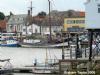
Wells-next-the-Sea is a truly salty little town on the North Norfolk coast, with a long history of seafaring.
It is set well back from the sea, in fact it's extremely unlikely you will be able to see it from seawards until virtually on it.
It is entered via a well buoyed channel, but shallows in the approach make entry dangerous in any kind of stiff onshore weather, (in common with all tidal havens on the North Norfolk coast). It is as well to remember that between Wells and the deep frozen wastes of the North there is no land barrier, nothing to soften or moderate winds and seas from that direction....
In less demanding conditions the harbour is well worth a visit, with much of the business of the town being connected with the sea in some way or another. At one time the town hosted an extraordinary number of pubs (ever heard the term "Drink like a Mariner" ?), but nowadays not so many. The visiting sailor will probably find the overall atmosphere most agreeable.
All visiting boats lay alongside shore accessed pontoons or take drying moorings. At dead low water there is approximately 2.5 to 3.0 metres of water at the pontoons
The town can supply most day-to-day needs for provisioning, while for the boat... liftings, repairs, and chandlery can be organised.
The harbour authorities are welcoming and helpful to visitors.
Approach
Caution:update 2021. If you thought you were "familiar" with Wells but haven't been here since 2018/19 you'd better have a look at their Navigation video because it's all changed - there are no kinks after the Pool so you go from the Lifeboat shed across to the salt marsh and back and then it's a straight run through to the pontoon
Navigation Video - Port of Wells
Boats much bigger than 10 m will need to make advance arrangements with the harbourmaster prior to entry.
The old red can buoy was replaced by a WCM in 2013 and that was moved considerably in the winter of 2014/15 and again in February 2016. This was moved again in 2017. The new position is 52 59'.700N 000 50'.194 E The buoyage up to the No 5 can buoy has changed significantly and the Admiralty has given up on the buoyage inbound from there. You should ignore the buoyage you have on any old Admiralty chart as it has no bearing on the reality of things here; Navionics has improved their buoy positions but they are overlaid on the old Admiralty tide lines.
If approaching from the East or the North there is a reasonable amount of deepwater in the approaches. There are shallow patches such as the Blakeney Overfalls with a minimum depth of over 2 m at CD, but in the kind of conditions you would want to be approaching Wells, this should not be problematic.
If coming from the West, especially the Wash area there are various shallows to take note of and avoid, e.g. Woolpack with the least depths of 0.2 m at CD. Again though in the kind of conditions suitable for entering Wells, and with a suitable rise of tide, a way through this these shallows can be found using the Sledway.
The main thing is that the Wells authorities now advise that you make your approach towards WCM from a westerly direction ie give the shifting sands to the East of the WCM a good offing. It would not be wise to try and shortcut between the yellow North Outer and the red South Outer if coming from the East (we tried that in the autumn of 2018 and had to alter course rapidly to go outside the North Outer as it started to shelve quite quickly!!)
In any kind of thick weather, or bad visibility it is probably wise to give the whole North Norfolk coast a very good offing altogether and go elsewhere. With any kind of North in the wind entry to Wells could be dangerous. The seas break in the approaches and the slightest miscalculation or mistake could end in disaster.
Further Pilotage Details...
Plan your first visit to Wells in light offshore summer conditions and you will be well rewarded. A link to the harbour's website is provided below:
http://www.wellsharbour.co.uk/
A word of warning: Although the channel buoys carry lights they all have the same light signature (Flashing 3s) which gives a confusing picture at night; the strong advice to have a spotlight for a night entry/exit should be followed.
In your approach you will probably see the Pine Woods laying just to the west of the harbour, and as you get nearer to the WCM it will be time to contact the harbour master on VHF channel 12, callsign " Wells Harbour". The harbour staff are on duty daytimes but also at night around HW. They are often around in their launch and are quite prepared to guide a first-time visitor in, especially at night. Other contact numbers for them are 01328 711646 (office) 07775 507284 (HM) 07876 743484 (Dep HM).
Most normal draft craft will be able to enter a couple of hours either side of high water, but take advice from the harbour master, and keep monitoring VHF channel 12.
The Admiralty chart wisely declines to show the local buoyage, leaving it to the harbour authority who move them around as necessary. The entrance channel through the sand is well buoyed and lit.
When making your run in over the bar and through "The Run" bear in mind that there can be a strong East going set to the tide from two hours before local high water (i.e. at the time you are likely to be going in). There is a real risk of being set on to Bob Hall sand and being pinned there especially if the wind is in the West too. It is probably best to favour the starboard side of the Channel going in and watch your track carefully.
In the region of the green buoy No.9 the channel turns to the south-east into The Pool, passes the lifeboat house on your starboard side and forms a wide sweep in the shape of an inverted C. Note that there are two port hand buoys marking the Southern edge of the channel into the Outer Harbour - leave these to starboard!! After that the channel is extremely narrow and it is necessary to hug the port hand beacons.
After passing the green buoy "Pool" the channel swings to the South West, follow the green buoyage on your starboard side back into towards the land. About two thirds of the way back towards the beach the channel swings gently to parallel the beach and continues in a straight line all the way to the mooring pontoon. This means that any records you may have in your chart plotter will lead you astray.
Update autumn 2018. We recently entered in a bilge keel yacht drawing 1.4 metres. The approach was started about 45 minutes before HW (neaps) The buoyage was followed religiously but we still managed to bottom twice on the way in. The instruction to "hug the red can buoys after the No 9 PHM " is very important. Basically the buoyage follows the channel but it is like the banks of a river - the deeper water is on the outside of the bends. We had the trace facility selected on our Navionics chart plotter and it showed just how far from reality that particular chart is. This proved useful on the way out next morning in the dark!! NB all the lit buoys have the same light signature which is confusing in the dark, luckily we had a spotlight and could follow the fluorescent buoys as well.
Berthing, Mooring & Anchoring
There are various berthing opportunities within Wells for the yachtsman or motorboater prepared to take the ground........
.........and consultation with the harbour master will be necessary to work out which options are best for you.
As a fin keeler you would be limited in areas to stay afloat and would probably be directed to raft against a boat called the Albatross on the Town Quay. The depth on the visiting pontoons varies from a couple of feet around the middle to five feet at the outer end. As has been said you need to have a chat with the HM about the best option for you. (Not sure what the drying height of the pontoons is but watch out for fenders being caught under the pontoon on the ebb tide - tends to stretch the guard rails somewhat!)
The Quay runs east to west and visiting yachts can use the Western end of it. Pontoons have been installed and again visitors can use a certain portion of these. There are various drying moorings with easy access to the town, and there are areas where you can lie to your own gear. There are even moorings for leaving your boat longer term...
The prices (2022) for short-term visitors have been simplified - it's £1 a foot per night with a minimum of £24 on the pontoon. and if you pick up a mooring it's half that.
You can lay to your own anchor for free for up to a week.
It has to be said that nearly all vessels choose to use the Quay or pontoons.
Although Wells could never be considered a harbour of refuge, it is a very useful staging post in a part of the world that is fairly devoid of passage harbours. For those making their way north from the East Coast, or for those heading to the East coast from the Humber area, Wells could be a strategic stopover in the right conditions.
Updated June 2022
Facilities
For the visiting boat electricity is available at the pontoons. Water is available at the pontoons and on the main quay.
They now have a new "Facilities Barge" which houses the showers and toilets along with a laundrette facility.
Diesel fuel is available at the fuel berth (tide permitting), and holding tank pumpouts can be arranged. Cranes and slipways are available, repairs and engineering are possible, while chandlery is buyable in town.
Petrol is over 5 miles away.
For the trailer Sailer there are slipways available with access at about half the tidal range. These are run by the harbour office and there are charges.
The Barclays bank has a cash machine, and there are various stores for provisioning.
Transport could be a problem. a Coast Hopper bus provides a year-round service between Hunstanton and Sheringham. (Half hourly in the middle of summer). At Sheringham there is a branch line station. For travel information contact Traveline East Anglia on 0870 608 2 608. The nearest mainline railway stations are at Norwich and King's Lynn.
History
Wells-next-the-Sea, known locally simply as Wells, is a town, civil parish and seaport situated on the North Norfolk coast in England.
The civil parish has an area of 16.31 km² and in the 2001 census had a population of 2,451 in 1,205 households. F
Wells is situated about 15 miles (24 km) to the east of the resort of Hunstanton, 20 miles (32 km) to the west of Cromer, and 10 miles (16 km) north of Fakenham. The city of Norwich lies 32 miles (51 km) to the south-east. Nearby villages include Blakeney (famous for its bird sanctuary), Burnham Market, Burnham Thorpe (the birthplace of Horatio Nelson), Holkham (with its famous stately home Holkham Hall), and Walsingham (a major medieval pilgrimage site).
Origin of name
The name is Guella in the Domesday Book (Latinized from Anglian Wella, a spring). This derives from spring wells of which Wells used to have many, rising through the chalk of the area. In 1580, there were 19 ships over 16 tons burden operating out of Wells, making it the major port in the area: the main trade was corn. The town was known as Wells-next-the-Sea in the early 1800s to distinguish it from other places of the same name. When the Wells & Fakenham Railway was opened on 1 December 1857, the terminus was given the name of "Wells-on-Sea". In 1956 the Wells Urban District Council voted to (re-)adopt the name Wells-next-the-Sea, and this has been the official name since then.
Geography
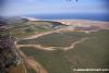
The town is now a mile from the North Sea, as a result of the silting of the harbour. The Holkham Estate reclaimed some 800 hectares of saltmarsh north-west of Wells, and this was completed with the mile-long sea-wall in 1859: this reclamation reduced the tidal scour and is itself a further cause of silting. The town has long thrived as a seaport and is now also a seaside resort with a popular beach that can be reached by a narrow gauge railway that runs partway alongside the mile-long sea wall north of the harbour. The beach is known for its long flat terrain, abstract sand dunes, varied unique beach huts and a naturist area situated to the west at Holkham. A land-locked brackish pool called Abraham's Bosom is used for pleasure boating and canoeing. The beach is backed by dense pine woods and a nature reserve. The pine woods are home to rare birds and a unique species of Corsican Pine.
More pinewoods exist to the east of the beach over the shipping channel at an area called the East Hills. This can be accessed on foot at low tide though all of the tidal sands in the area are extremely dangerous due to the speed and currents of the rising tide. It is not advisable to cross the channel without detailed local knowledge.
The town stretches nearly a mile inland. The majority of shops and other such businesses are now found on Staithe Street but up to the 1960s commercial premises were also to be found along High Street which continues south towards St Nicholas's Church. The church burned after a lightning strike in 1879: the exterior shows the original stonework, but the interior is sparse and lacks interest. John Fryer, Captain Bligh's sailing master on HMS Bounty was born at Wells, and is buried in the churchyard.
The distinctive landmark of the seafront is the granary with its overhanging gantry on the quay, finished in 1904. This is now converted to flats. The maritime tradition of the town meant it used to have a remarkable number of public houses for a town of its size although many of these have since closed. The northern end of the town used to be notable for parallel "yards", narrow rows of cottages similar to the northern "ginnels", which could be relics of Danish occupation. These were largely lost in the terrible 1953 flood damage, and subsequent "slum clearance".
A feature of the town is the area known as The Buttlands – a name suggesting archery practice historically – which is a large green ringed by lime trees. Large elegant Georgian houses overlook The Buttlands, as do the Crown Hotel, Globe Inn and the Wells Catholic Church. If you exit The Buttlands down the hill at its south-west corner you can see Ware Hall, which was rebuilt over a period of years from the 1970s by Miss May Savidge, who brought it in parts when she moved from Ware in Hertfordshire.
Railways
Formerly the town was served by Wells-On-Sea railway station and was connected to the national rail network by two lines. The line westwards towards King's Lynn was never reinstated after damage in the 1953 East Coast Floods, while the line to Norwich via Fakenham, Dereham and Wymondham was a victim of the "Beeching Axe" of the 1960s. The Wells and Walsingham Light Railway, a 10¼ inch-gauge railway (the longest of such a gauge in the world), now uses part of the track-bed and has its own separate Wells railway station.
The Wells Harbour Railway is a separate 10¼ inch-gauge railway that takes passengers from the harbour behind the sea wall towards the beach and caravan site.
Near the centre of the town is a field studies centre in buildings that were formerly Wells County Primary School (linked by School Lane from High Street). The junior school was relocated to the former Secondary Modern school when a new secondary school was built in the late 1960s, using the former railway line to the west towards King's Lynn.
Lifeboat station
The current lifeboat station, housing both an all-weather lifeboat and an inshore rescue boat, is at the harbour entrance
The old lifeboat house, now used as the harbour offices, is at the western end of the quay
Cuisine
A local delicacy is samphire or glasswort (salicornia europaea), a fleshy edible plant which grows in the intertidal mudflats and saltmarshes. Samphire is collected by locals and can be seen for sale in the town in summer. The locals boil the samphire, then serve it hot with butter or malt vinegar. The fleshy parts are held in the mouth and the flesh removed from the stalks by dragging them through your teeth. Rock samphire (crithmum maritimum) is a different plant.
Wells is famous for its fish and chips. There are two dominant fish and chip shops facing the quay which supply the hordes of tourists and daytrippers who flock to Wells throughout the year. While it is possible to eat in, in good weather most people chose to sit on the low wall that runs along the length of the quay eating their chips from polystyrene trays. Its somewhat odd to note that many will sit facing the nondescript buildings and shopfronts rather than the attractive views over the quay and marshes. Eating "chips on the quay" is a popular pastime in Wells.
Local fishermen continue to land crab and other shellfish on the quay. Good quality fresh seafood is available on the quay and in a local wet fish shop. In the 1950s and 1960s, a set of sheds at the end of the East Quay were the focus for a whelking industry. Whelks (shellfish) were caught by a small fleet of whelk boats. The whelks were boiled before being sent (originally by train) to market.
Lifeboat Disaster in 1880.
The Wells lifeboat disaster occurred in 1880 when the RNLI lifeboat Eliza Adams, based at Wells-next-the-Sea in the English county of Norfolk, attempted to go to the aid of the stricken brig Ocean Queen in heavy seas and was lost along with 11 of its 13 crew.
At this period in time, the Wells lifeboat was an open boat propelled by a combination of oars and sail, and based at the old lifeboat house on the quay at the head of Wells harbour. Because of the strong tides in the mile long channel that connects the quay with the harbour mouth, it was common for the lifeboat to use the services of a steam tug to be towed to sea.
On October 29, gales were lashing the north coast of Norfolk. The Ocean Queen, of 171 tons and built in Sunderland in 1838, was on passage from Southampton to Seaham when she was caught in the storm and sought shelter at Wells. At 1pm, the Wells lifeboat launched to the aid of another brig, the Sharon Rose, which had run ashore on the beach at nearby Holkham. Seven sailors were rescued from the vessel and the lifeboat returned safely to Wells. However on arrival back to the quay, the Ocean Queen was seen close to the harbour entrance, flying a distress flag.
After changing 8 of her 13 crew, the Eliza Adams was again towed to sea. By this stage the Ocean Queen had been driven ashore on the nearby sands. The lifeboat reached the brig, but was unable to help and so set sail to return to port. In so doing, a heavy wave broke over the lifeboat and it capsized.
Eleven of the 13 crew drowned, leaving 10 widows and 27 children without a father. One crew member, William Bell, managed to stay with the boat until it righted itself. Another, Thomas Kew, was washed ashore alive. A memorial to the members of the Wells lifeboat crew who lost their lives stands adjacent to the old lifeboat house, now used as the harbour offices.
The crew of the Ocean Queen remained aboard their vessel, and were able to walk ashore once the storm had abated and the tide receded.
A lifeboat station, housing both an all weather lifeboat and an inshore rescue boat, still exists at Wells. The current lifeboat station is located at the harbour entrance.
The text on this HISTORY page is covered by the following licence
http://en.wikipedia.org/wiki/Wikipedia:Text_of_the_GNU_Free_Documentation_License
Eating, Drinking & Entertainment
For such a small place with less than 3000 inhabitants there is quite a remarkable array of eating and drinking places.(But somewhat less than the 32 pubs the town once hosted in it's swaggering seafaring past)
Starting with the ubiquitous fish and chips through various ethnic restaurants and pub dining...... they are all available here. The skipper and crew won't go hungry.
Check the links below for a few ideas, or just have a wander around and see where your nose leads you :
Pubs:
www.beerintheevening.com/pubs/results.shtml/el/Wells%20next%20the%20Sea%3BNorfolk/
Eating Out:
Links
|

Your Ratings & Comments
Fri 26 May 2017
Back
PORT OF WELLS
NOTICE TO MARINERS
Change to navigable channel
URGENT
A new navigable channel has opened up on the Run between Ben Taylors buoy and Walkers Jetty. The new channel has been cleared of moorings and all the Port hand buoys have been moved from the old channel to the new channel.
At the Southeast corner of the channel at Walkers Jetty there is a high sandbank which is marked with port hand buoys. Please do not attempt to sail over this bank.
New Position
No 16 Buoy Lat 52°57'.857N Long 000°51'.075E
Robert Smith
Harbour Master
Port of Wells
West Cardinal new position 52°59'.587N 000°51'.580E
http://www.wellsharbour.co.uk/getin.htm
Latitude 52°59'.642N
Longitude 000°51'.028E
Flash : VQ (9) 10s
View all 13 feedback items