 Medway 2
Gillingham Reach to Rochester Bridge, inc the Marinas
Medway 2
Gillingham Reach to Rochester Bridge, inc the Marinas
At a Glance
Download Guide
This section deals with the River Medway from Gillingham up to Rochester Bridge.
As opposed to the first section of the Medway which appears to be a vast open expanse of water at high tide, in this section the River is far more confined.In this section also there are many facilities for a visiting yachtsman, including three marinas plus several boatyards and clubs. The scenery varies from depressingly industrial to pleasantly rural on the northern banks. Navigation is straightforward but shipping is still encountered, although not of the size found nearer to Sheerness.
A yacht will find its progress blocked by the bridge at Rochester, but motorboats can carry on as far as Allington, and then via locks as far as Maidstone. This part of the Medway is covered in a separate article.
The area has a history deeply interwoven with the Navy, with the huge Chatham dockyards that once built and refitted ships. Some details are provided in the history section. The Dutch once sailed up the River and gave the Navy perhaps the biggest drubbing it's ever had... details of this are in the history section attached to Medway 1, covering the entrance at Sheerness to Gillingham Reach.
With the Navy dockyards only closing in the 80s, there is an abundance of skilled nautical workers in the general area. Certainly in the 90s it was possible to get just about any kind of work done on a big heavy boat, from dry docking to repairs and fabrications.
All normal town facilities can be found in Gillingham and Rochester, with town facilities on the other bank being a bit thinner on the ground.
This part of the River is under the control of the Peel Ports Authority, they request that you keep listening watch on VHF channels 74 and 16.
Medway 2, Gillingham Reach to Rochester Bridge, inc the Marinas
Approach
Approaches from the sea to this area have already been covered in article called Medway 1, which deals with approach to Sheerness, and Sheerness as far Gillingham Reach.
From Folly Point (westwards of which there is a 6 kn speed limit) the buoyed channel runs westwards with Hoo Island to the North and Gillingham Marshes to the South. Shortly after passing the red can buoy No. 28 (Fl.R.5s), which you leave to port you will come to the first yachting facility.
Pilotage information:
The entrance to Gillingham Marina can be identified by a large cream coloured building situated just to the west of it's lock gates. Berths can be had here in a locked inner basin or just a bit further on in the tidal basin. Full details will be given shortly.
The River starts to swing to the North West, and you will see the entrance to the docks lying almost ahead of you, and between Gillingham Marina and the docks there is a timber pier, followed by an inlet. This is a Gillingham Pier, and the inlet contains a slipway, some moorings and facilities. This is covered more fully a bit later.
Past the entrances to the ship docks, the River trends northwest for a while with the south-westerly bank following the dock walls. Once past Hoo Island on your starboard side there is a fairly large expanse of drying mud outside of the main River. The deepwater is defined by heavy mooring buoys on your starboard side and yacht moorings on your port side at this point.
Hoo Marina, the second yachting facility you will come to lies across these mudflats to the North.
In November 2013 the adjacent Port Werburgh took over this marina and at the moment has no facilities for visiting yachts. These notes on how to get in there have been left on our site for interest and in case they reverse that policy some time in the future.
It can either be accessed directly across the mudflats given a sufficient rise of the tide, or through a twisting little gutway marked in yellow or the chart. This is known locally as the Orinoco channel, and has significantly more water than trying to go across the mud.
The start of this channel is identified by a small unlit westerly cardinal buoy lying just inside the trot of heavy craft moorings, and it is marked by withies. This Marina can also be accessed via a small marked channel that runs around the North of Hoo Island, also marked on the chart. Access to this channel from the East is in the region of the green conical buoy Darnett No. 23 which is in the main River Medway just off this chart. (See Medway 1 article). Just to the South West of this buoy you will find a small unlit green buoy No.1, and generally westerly course with a touch of North will bring you to the small unlit red can buoy West Hoo No.2 which is on the chart.
This channel also gives access to Whitton Marine via West Hoo Creek.
If heading for Hoo Marina via this route let the chart be your guide and follow the channel round with one eye on the depth sounder. It is important to identify the beacons marking the gap in the causeway and pass between them. Once past these beacons head South West towards the unlit westerly cardinal buoy lying just away from the heavy craft moorings. About halfway there you can swing hard to starboard picking up the Orinoco Channel mentioned above, marked by withies.
This channel may look a little tricky and unpromising, but I have taken a 60 ton MFV through the middle channel and up the drying West Hoo Creek to the facilities of Whitton Marine more than once..
More about Hoo Marina follows.
Assuming you are pushing on towards Rochester and not diverting, your path up River is fairly clear and easy to follow from now on. It is well marked by buoyage and also significant numbers of small craft moorings on either side.
As you pass through Cockham Reach you will see industrial dockyard type scenery to port and more pleasant wooded scenery to starboard. The River bends round to port while on your starboard side amongst the small craft moorings you will have passed the Medway Yacht Club, the village of Lower Upnor with Upnor Sailing Club and thrusting out into the River, Upnor Jetty. This is Upnor Reach, and it heads south with a touch of West as far as Chatham.
Again, the run of the River is defined by the small craft moorings on either side. Opposite Upnor Castle and Upper Upnor Village on your starboard side you will see the lock at the entrance to Chatham Maritime Marina. It has traffic lights, and a newish looking building with a little clock tower on top.
This MDL Marina is formed within the old dockyard, and access is by the above-mentioned lock. There is 24-hour access for boats of 1.5 m draft or less, and the lock remains open for free flow at certain times. Full details of this facility will be given shortly.
From here through to Rochester Bridge there is very little in the way of facilities for yachts or leisure craft. There is a facility calling itself Victory Marina on the port side just past the entrance to Chatham marina; we rang to enquire if they take visiting boats and were told that they did if they have space but they refused to give any further information. If planning to pass under the bridge which has an air draft of 5.4 m at HWS (obviously a bit more at lower tides) it is simply a matter of continuing up River, which now becomes far more industrialised.
Continue South down Chatham Reach, round the U bend to starboard at Chatham Ness and generally NNW up Limehouse Reach followed by a another U bend to port at Gashouse Point, and then under the bridge. There are various piers and landings plus plenty of heavy mooring buoys and shipping wharfs. If you do get this far you may be unsurprised to find a derelict Russian submarine rotting away on moorings. In fact there seems to be quite a few rusty looking barges and other vessels festering away in this area.
This just about covers the waterborne journey from Gillingham to Rochester Bridge.
£ GMT
Waypoint
Charts
Rules & Regs
Hazards
Tides
Berthing
Marina facilities are covered (with prices) in the order you come across them from the sea,....
.... Gillingham Marina, Hoo Marina, and Chatham Maritime Marina. There are other mooring facilities around this area for longer term customers, esp. those who can take the ground.
Unless you have a small boat able to take the ground, there is no real opportunity for anchoring in the area described, as the channel is too narrow. A bilge keeler could take the ground in the area to the south of Hoo Marina after a bit of a recce at low water.
Gillingham Marina.
The lock entrance to Gillingham Marina, lies just to the east of the large cream-coloured building that you will see in the approach. Normal draft craft can have access approximately 4 1/2 hours either side of high water, with the lock being in operation from 6 AM to 10 PM in the summer, but only in daylight hours during the winter. Watch the crosstide in the run in to the lock.
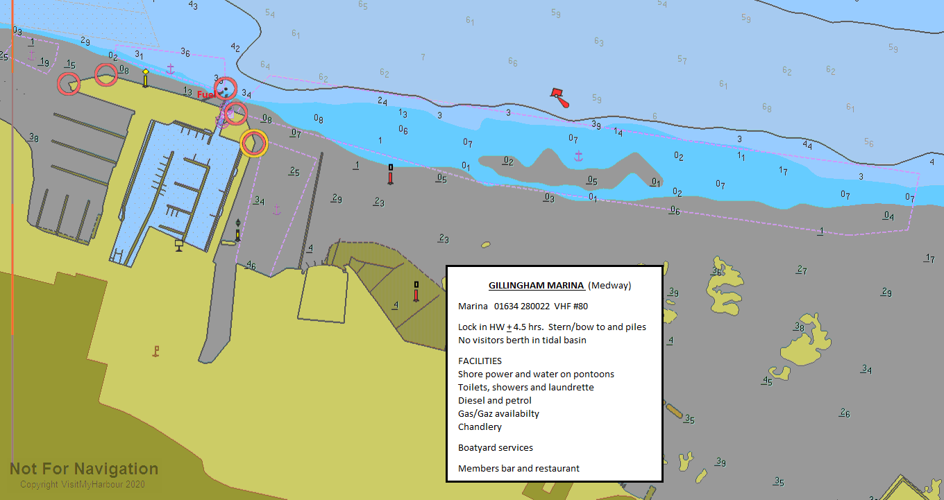
If intending to give them a try, call Gillingham Marina on VHF channel 80 to arrange a lock in. They are on telephone 01634 280022 and we provide a link to their website below:
http://www.gillingham-marina.co.uk/
If you are over about ten metres it wouldbe best to give them a bit of notice to make sure they have room
There is a tidal basin to the west of the locked marina but they no longer have any visitors berths there.
All normal Marina facilities are available here including water and electricity, showers, toilets, and a launderette. For the crew there is a pub restaurant on site was been moved into the Waterfront Leisure Centre where one can make use of their other facilities on payment of a visitors membership fee. For 2014 the original bar/restaurant in the marina (which was moved) has now been reopened. There is a further pub within 10 minutes walk. The town of Gillingham is walkable too.
For the boat they have a 65 tonne travel lift, with engineers and sailmaker on-site. Holding tanks can be pumped out, and Camping gas and Calor gas can be obtained, with a chandlery on hand.
Prices here (2022) come out at £3.30 per metre per night in the Marina (which is the same as it was in 2020!); they no longer have any designated visitors berths in the tidal marina.
Hoo Marina.
Hoo Marina was taken over by Residential Marine Ltd in November 2012, is now known as Port Werburgh and is undergoing re-organisation. At the time of writing (March 2018) they were no longer accepting visiting boats but this may change in later years.
Chatham Maritime Marina.
This is another offering from MDL and the newe st Marina in the area, having opened in 2001. Access is via the lock already described, and boats of reasonable draft (say 1.5 m) can get 24-hour access. A holding pontoon is outside, just downstream of the entrance. The lock is 8.5 metres wide and the tides can run hard directly across the entrance so some care needs to be taken when entering.
Just the watch the way locally moored craft are lying and make allowances in your approach. There are no confusing tidal eddies to contend with.
There are floating pontoons within the lock and entry and exit are controlled by traffic signals. Around high water there can be a free flow periods, but even so the lifting road bridge needs to be raised before you can enter or leave....so it is essential to call the marina on VHF channel 80 or telephone 01634 899200 to arrange a lock in or a berth. Visitors prices (2022) work out at £4.15 per metre and includes shore power hook up. A link to their website is provided below:
They have added another pontoon on the end of the existing ones, designated as "G" & "H" pontoons
All the usual MDL facilities will be found here, water and electricity on the pontoons, decent showers and toilets, laundry, WiFi, tight security etc etc.
Diesel and petrol are available at the fuel dock inside, and boats up to 18 tonnes can be lifted with shoreside storage.
The area is under development and changes are coming along nicely. At present the visiting mariner will find within a five minute walk...
A pub/restaurant (with rooms), the hotel Ramada Encore for when "she who must be obeyed" has just had enough of all that sailing lark, six other restaurants of various cuisines, while most importantly for the cruising boat owner, a Co-op convenience store (7am to 11pm) and a fish and chip shop. An outlet shopping mall which can also provide fast food during daytimes (for the shopaholics on board) and a nine screen cinema (for the fidgeting teenagers) complete the scene.
For those of us with an eye for history, this area is rich... Try the Dickens World indoor visitor attraction or visit the Historic Dockyard and other military museums, which are highly rated tourist attractions, in fact a must for anyone of a nautical and/or military persuasion. In the long distant past the Dutch sailed up the Medway and gave the Navy a good trouncing on their home ground....you'll find all the gritty details in our Medway 1 coverage.
The explorative will find the towns of Chatham and Rochester are a short shuttle bus ride away for a serious stock up, but public transport is more limited in the evenings.
This just about covers the Marina facilities in the area, although there are other mooring possibilities touched on soon.
Marinas and Mooring
Medway Pier Marina
Pier Head Buildings, Gillingham Pier, Gillingham, Kent. ME7 1RX
Marina Developments Ltd
Chatham Maritime Marina, Leviatthan Way, Chatham, Medway, Kent. ME4 4LP
Facilities
The facilities available at the individual marinas have already been covered, and this article is of a more general nature.
There are several yacht clubs in the area some of whom maintain a couple of visitors moorings, or may be prepared to let you use a members mooring.
Some links are provided below to local Yacht Clubs, who can provide more information about this as well as other local matters.
Medway Yacht Club: This club does offer moorings to visitors and has a page on their website for visitors
http://www.medwayyachtclub.com/arriving-by-water/
Hoo Ness Yacht Club: This club also welcomes visitors; see their link
http://www.hooness.org.uk/visitors.php
Upnor Sailing Club:
http://www.upnorsailing.co.uk/
Strood Yacht Club:
http://www.stroodyachtclub.jimdo.com
Rochester Cruising Club:
Medway Cruising Club:
http://www.medwaycruisingclub.org.uk
For the trailer sailer there is a public slipway at the Strand, Gillingham which is available at about three quarters of the tidal range. It is only suitable for small trailers that can be manhandled along the slipway.
At Gillingham Pier there is a cobbled slipway again available at three quarters of the tidal range. This is suitable for vehicles and there is a charge payable to the pier master.
In either case remember the speed limit of 6 kn in the immediate area. Speedsters can head out to past Folly Point and zoom away to their hearts content with plenty of room available in the main River.
Next door to Gillingham Pier is a small mud berth Marina, with about 35 drying berths. Medway Pier Marine are on 01634 851113.
Interesting story about this place... there was a very nice large motor yacht called White Star moored here for a long while. It had actually belonged to a director of the White Star Line, and the frosted glass in its patio doors had the White Star logo beautifully set into them. Presently it set off for the Mediterranean with the owner and a local paid crewman on board.
Shortly after this the police were sniffing around trying to find the owner.... turns out he had been leasing lots of cars and then selling them as if they were his. He then did a bunk aboard White Star. When he returned the local crewman said that this owner was an absolute kleptomaniac.... wherever they stopped he couldn't help himself from stealing something, silly things like hoses and plugs.
Fast forward a few years to 1995, and I had arrived and got tied up in Lazeretto Creek in Malta. Laying there stern to, looking splendid, was White Star. I quickly established that it had a new owner now, and was chatting with him about the scam carried out at Gillingham. The new owner confided in me that he had been getting very confused by the number of car log books he kept finding hidden away all over the boat....
Fast forward yet again to 2009, I find White Star moored stern to in Almerimar, Spain ! It's a small world for big boats !
Gillingham Pier.
At one time when under the control of D.C. Marine, Gillingham Pier used to provide some very useful Marine services, including light and heavy weight moorings in the River, fuel berth, water and bottled gas on the pier. They provided dry docking for large craft and could arrange all kinds of work from steel fabrications to specialist engineering. My MFV was moored happily there for a good few years with many improvements carried out with their help.
Lately a company called Boatquays had control of the pier. They were more of a boat brokerage company, and apparently have now gone bust.
Hopefully Gillingham Council who are ultimately the owners, will re let this very handy facility to an outfit who will perform some useful function for boat owners, especially those with larger boats not suitable for marinas...
Around this area there are plenty of repair and dry docking facilities for small and not so small craft. Check out the directory.
If berthed anywhere at all in this area, Gillingham, Chatham and Rochester are the local towns. All the usual town facilities will be found in these areas including banks and supermarkets, plus rail connections with services to London, Ramsgate, and Dover. It depends on where you are as to which town is nearest and how difficult it is to reach. For those lucky enough to own one there is helicopter landing pad at Gillingham Marina, thus solving all your transport problems!!
Boatyards & Boatyard Services
Chandlers
Pirates Cave Chandlery
Unit 14 Northpoint Business Estate, Enterprise Close, Medway City Estate, Rochester, Kent. ME2 4LX
Bosuns Locker
10 Military Road, Royal Harbour, Ramsgate, Kent. CT11 9LG
What to Do
It is very difficult to describe what is available....
.... for eating drinking and entertainment in an area that is as spread out as this.
Local facilities on top of the marinas have already been touched on, and it is unlikely that the visiting Mariner will be tempted to stray miles from his boat. The one exception to this may be if you are in Gillingham Marina and are prepared to take a reasonable hike to Gillingham Town. Gillingham is only a small workaday type of place, but can offer a reasonable choice of pubs and restaurants. As usual it is beyond the scope of this article to delve too deeply, so we provide a couple of links for further investigation:
Pubs:
http://www.beerintheevening.com/pubs/results.shtml/el/Gillingham%3BKent/
Eating Out:
THE 10 BEST Restaurants & Places to Eat in Gillingham 2023 - Tripadvisor
Yacht Clubs and Associations
History
Chatham Dockyard, located on the River Medway and of which two-thirds is in Gillingham and one third in Chatham, Kent, England, came into existence at the time when, following the Reformation, relations with the Catholic countries of Europe had worsened, leading to a requirement for additional defences. For 414 years Chatham Dockyard provided over 500 ships for the Royal Navy, and was forefront of shipbuilding, industrial and architectural technology. At its height, it employed over 10,000 skilled artisans and covered 400 acres (1.6 km²). Chatham dockyard closed in 1984, and 84 acres (340,000 m2) of the Georgian dockyard is now managed as a visitor attraction by the Chatham Historic Dockyard Trust.
Outline history
* The Treasurer of the Navy's accounts of the King's Exchequer for the year 1544 identifies Deptford as the Dockyard that carried out all the major repairs to the King's Ships that year. That was soon to change, although Deptford remained a dockyard for over three centuries.
* In 1547 Jillingham (Gillingham) water, as Chatham Dockyard was then known, is mentioned as second only in importance to Deptford; followed by Woolwich, Portsmouth and Harwich. In 1550 ships that were then lying off Portsmouth were ordered to be harboured in Jillingham Water, "by reason of its superior strategic location" .
* Chatham was established as a royal dockyard by Elizabeth I in 1567. She herself visited the yard in 1573. By the late 17th century it was the largest refitting dockyard, important during the Dutch wars.
* It was, however superseded first by Portsmouth, then Plymouth, when the main naval enemy became France, and the Western approaches the chief theatre of operations. In addition, the Medway had begun to silt up, making navigation more difficult.
* Chatham became a building yard rather than a refitting base. In 1622, the dockyard moved from its original location (now the gun wharf to the south) to its present site. Among many other vessels built in this Dockyard and which still exist are HMS Victory, launched in 1765 - now preserved at Portsmouth Naval Base (formerly Portsmouth Royal Dockyard), and HMS Unicorn, (a Leda class frigate) launched 1824 - now preserved afloat at Dundee (in Scotland).
* Between 1862 and 1885, the yard had a large building programme and St Mary's basins were constructed along St Mary's creek. The three basins were 28 acres (110,000 m2), 20 acres (81,000 m2) and 21 acres (85,000 m2). There were four new dry docks. Much of the work was done by convict labour. The construction materials required regenerated the North Kent brick and cement industries. It is estimated that 110 million bricks were used. These basins formed the Victorian Dockyard. Chatham built on average, two new ships each year.
* When the yards at Deptford and Woolwich closed in 1869, Chatham again became relatively important and remained so until 1983 when it closed.
* With the twentieth century came the submarine. The C17 was launched at Chatham in 1908, and during World War I, twelve submarines were built here, but when hostilities ceased uncompleted boats were scrapped and it was five years before a further ship was launched. In the prewar years, 8 'S' class submarines were built. This was a period of decline. During World War II there were 1,360 refits and sixteen launchings.
* The final boats constructed in Chatham were Oberon class submarines - Ocelot was the last vessel built for the Royal Navy, and the final vessel was Okanagan built for the Royal Canadian Navy, launched on 17 September 1966.
* In 1968, a nuclear submarine refitting complex was built complete with refuelling cranes and health physics building. In spite of this in June 1981, it was announced to Parliament that the dockyard would be run down and closed in 1984.
The Georgian site is now a visitor attraction, under the care of the Chatham Historic Dockyard Trust. The Trust is preparing an application for the Dockyard and its Defences to become a World Heritage Site . The Basins have new uses, St Mary's Island is now housing and part of the Victorian Dockyard forms the portal to the Medway Tunnel. Other military buildings have now been refitted and are used by the Universities at Medway.
Closure and regeneration
The dockyard closed in 1984. It covered 400 acres (1.6 km²). After closure this was divided into three sections. The easternmost basin was handed over to the Medway Ports authority and is now a commercial port. 80 acres (324,000 m²), comprising the 18th century core of the site, was transferred to a charity called the Chatham Historic Dockyard Trust and is now open as a visitor attraction. The other tranche was converted into a mixed commercial, residential and leisure development.
St Mary's Island, a 150-acre (0.61 km2) site, once a part of the Dockyard, has been transformed to a residential community for some 1,500 homes. It has several themed areas with traditional maritime buildings, a fishing (in looks only) village with its multicoloured houses and a modern energy-efficient concept. Many homes have views of the River Medway. A primary school (St. Mary's CofE) and a medical centre provide facilities for the residents and there are attractive walks around the Island.
The text on this HISTORY page is covered by the following licence
http://en.wikipedia.org/wiki/Wikipedia:Text_of_the_GNU_Free_Documentation_License
Local Business
Boat Charters
Linton Motor Yacht Charters
Linton House, Linton Road, Loose, Kent. ME15 0AD
Divers/Diving and related services
Marine Engineering
MS Cooper Marine Services
Building 81 The Garage, The Historic Dockyard, Church Lane, Medway, Chatham, Kent. ME4 4TE
Ship Services
Unit 14 Central Business Park, Neptune Close, Medway City Estate, Rochester, Kent. ME2 4LW
KMS Medway Marine Engineers
Box 23 Medway Bridge Marina, Manor Lane, Medway, Rochester, Kent. ME1 3HS
Rowan Yacht Services (Yanmar)
Hoo Marina, Vicarage Lane, Hoo, Rochester, Kent. ME3 9TN
Energy Solutions UK Ltd
Property House, George Summers Close, Medway City Estate, Rochester, Kent. ME2 4EL
Marine Electrics/Electronics
Ships Electronics Services Ltd
Waterside Court, Neptune Close, Rochester, Kent. ME2 4NZ
Outboard Sales and Service
Power Products Marine
Unit 2 Ballard Business Park, Cuxton Road, Strood, Rochester, Kent. ME2 2NY
Sea Schools
Rigging and Riggers
Medway Sling Company Ltd
Rochester Test House, Knight Road, Strood, Rochester, Kent. ME2 2AH
Sailmakers, Repair & Covers
Other-Businesses
Viking Recruitment Ltd
Aycliffe Business Centre, Archcliffe Road, Dover, Kent. CT17 9EL
Moor Fast Marine Ltd
Fleet House, Upnor Road, Lower Upnor, Rochester, Kent. ME2 4UP
Skipper UK Ltd
Beacon Boatyard, Manor Lane, Borstal, Rochester, Kent. ME1 3JN